
Bill Meck
@BillMeck
Followers
18,973
Following
52
Media
6,026
Statuses
13,677
Chief Meteorologist for LEX-18
Lexington, Ky
Joined September 2009
Don't wanna be here?
Send us removal request.
Explore trending content on Musk Viewer
Drake
• 1722789 Tweets
Meet the Grahams
• 232413 Tweets
Family Matters
• 172674 Tweets
#بدر_بن_عبدالمحسن
• 148180 Tweets
みどりの日
• 144128 Tweets
Kdot
• 94637 Tweets
Óscar Puente
• 55317 Tweets
結束バンド
• 52477 Tweets
京都新聞杯
• 44108 Tweets
#StarWarsDay
• 34803 Tweets
スペイン村
• 33069 Tweets
Bournemouth
• 25611 Tweets
#超こどもの日
• 23990 Tweets
Bad Apple
• 21480 Tweets
#MayThe4th
• 20635 Tweets
#MUSICFAIR
• 16854 Tweets
الفردوس الاعلي
• 15848 Tweets
رياض الجنه
• 15385 Tweets
الامير الشاعر
• 15157 Tweets


In case you're keeping score at home...the 107 DEGREES BELOW ZERO at Mt. Washington, New Hampshire, is the COLDEST wind chill ever recorded in the US. The current air temperature is 46 BELOW ZERO. It is the top of a high mountain, so it does skew the numbers, but WOW.
#kywx

43
260
672
Why did the barn cross the road? To get to the other side. Historic barn built in 1931 was moved across Nicholasville rd at Brannon. After the prep work it took just 10 minutes to make the trip. Wonderful preserving history!
@LEX18News

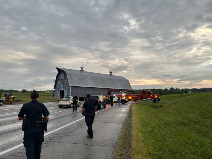
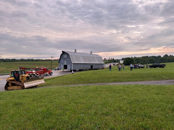
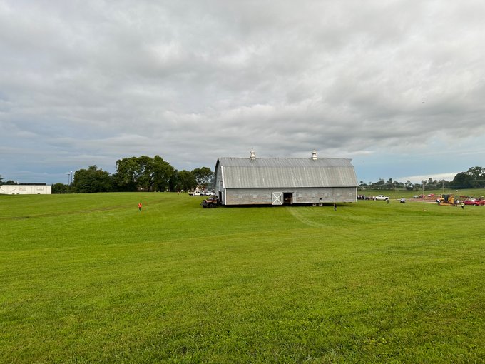
3
30
326
If you've enjoyed watching LEX 18 NEWS over the last 20 years with Kevin, Nancy and I, today is your last chance. My colleague and friend, Kevin Christopher is retiring after today's 6:00 News. Lexington TV will be a little bit less with your departure. Cheers my friend!
19
15
313
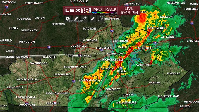
We're losing an old friend...the Maxtrack Doppler is coming down after 18 years today. Let's put it this way, it's still running Windows XP...but later this week Maxtrack 2.0 will take its place!
@lex18news

18
16
212
It's now confirmed...Monticello Kentucky was THE COLDEST place in the lower 48 states this morning!!!! A most unique accomplishment in our little corner of the world. It's amazing what radiational cooling and a decent snow cover will do.
#18StormTracker
#kywx
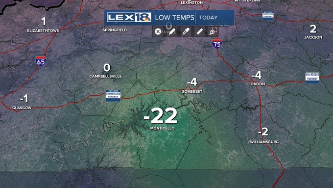
10
23
176
Thank goodness the temperature stayed at 32-33 degrees all day in central Kentucky compared to 31-32. We saw almost 2 inches of 33 degree rain. We still did end up with freezing rain and sleet in the evening with bad travel conditions, but it could have been a whole lot worse!
11
9
163
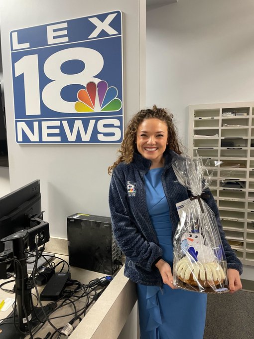
Congratulations to METEOROLOGIST Bayne Froney

We want to send a big CONGRATULATIONS to our
@baynefroney
!!!
She has earned a Master of Science degree in Geosciences with a concentration in Applied Meteorology at Mississippi State University.
We're so proud of you. ❤️
20
8
264
8
2
137
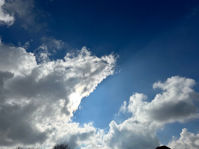
DON’T PANIC! the sky has mysteriously turned shades of blue and there is a big bright glowing thing up there. I think this is a good sign.
6
9
126
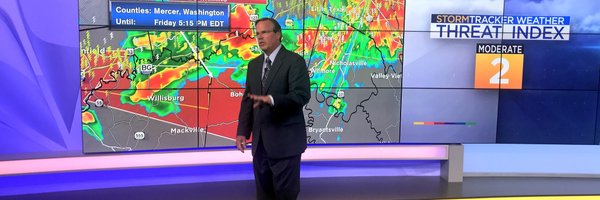
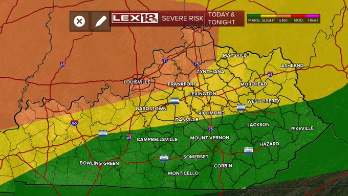
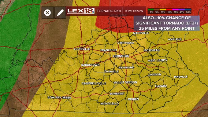
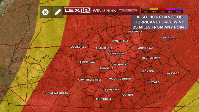
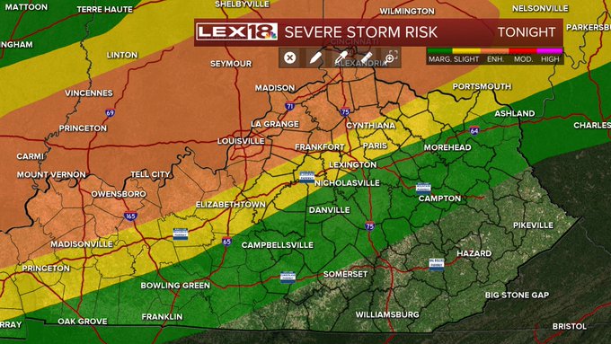
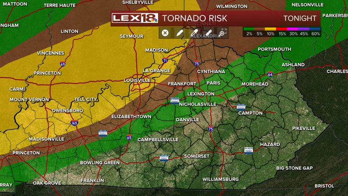
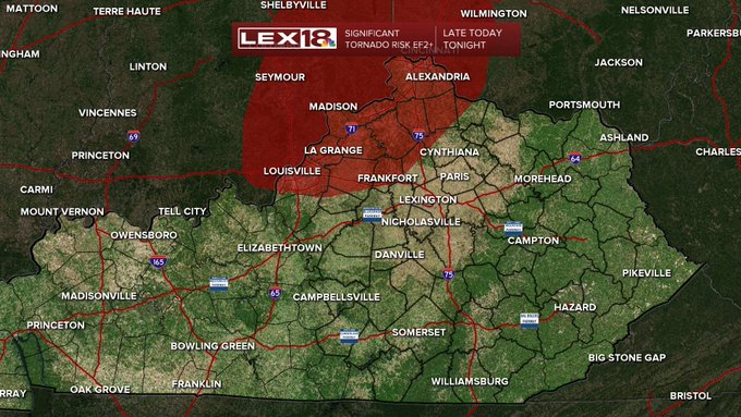
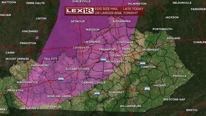
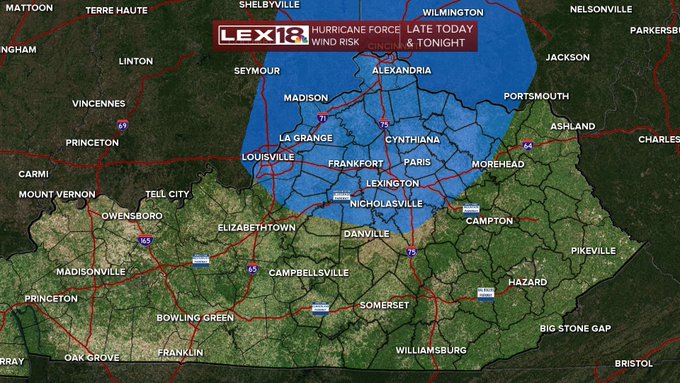
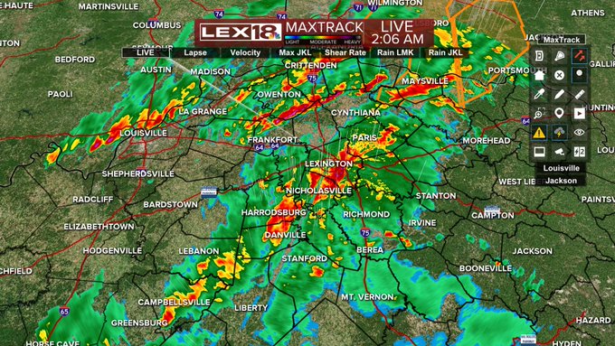
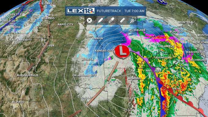
STAY WEATHER AWARE LATE TONIGHT THROUGH TOMORROW NIGHT! A SIGNIFICANT severe weather risk exists with 2 different waves of storms. 1st is after midnight, 2nd Tuesday afternoon/evening which looks to be bigger of 2. Keep info sources handy and stay aware!
#18StormTracker
#kywx

2
35
95
STAY WEATHER AWARE TODAY! A significant severe weather outbreak is possible late today and this evening. Keep an info source handy. Greatest threat after 6. Very large hail, damaging wind and tornadoes are possible. Think about your severe weather plan


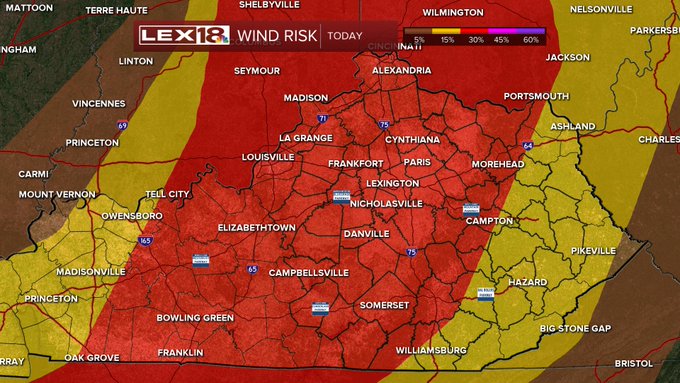
1
28
93
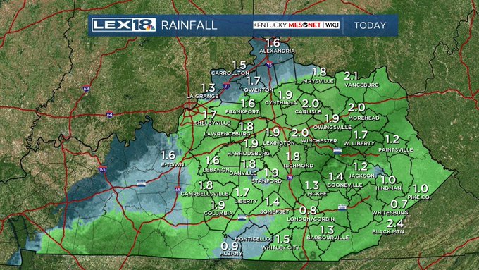
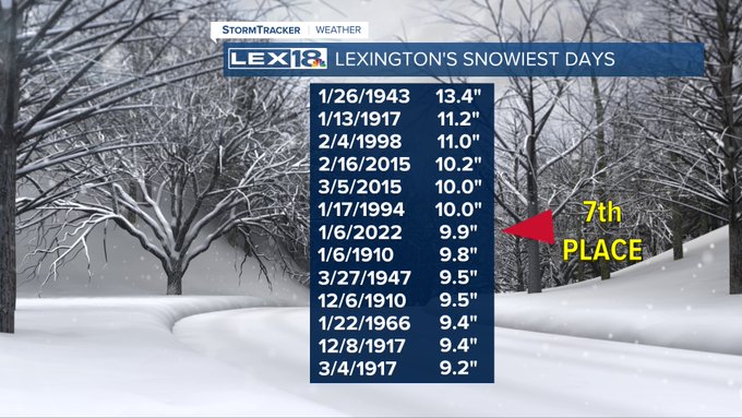
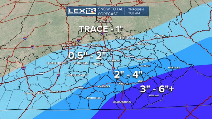
An update on the historical significance of today's snowfall. We picked up another 9/10" at the Blue Grass Airport after 7:00 which raised the total snowfall to 9.9" today. This moved us up to the 7th snowiest day in Lexington's weather history.
@lex18news
#kywx
5
26
87
Always like to give you a little reason for optimism. We're now in Solar Spring! Without getting too confusing, it's simply the quarter of the year where we see the greatest increase in daylight hours. Real spring is March 20th but after the last month, anything sunnier is good!

4
6
81
A tradition resumed today as Bill's Weather 101 visited Wilmore Elementary School's 4th Grade. We were there every year from 1999 to the pandemic and had started seeing the 2nd generation of kids. The school secretary remembers me coming to her 4th grade class...great school!
3
3
79
There's an old wives' tale that the number of August fogs gives you the number of snow days in the winter. After today's fog we're sitting at 10, so that gives snow lovers something to hope for. Just something cool to think about before the heat next week.
#18StormTracker
#kywx

9
15
78
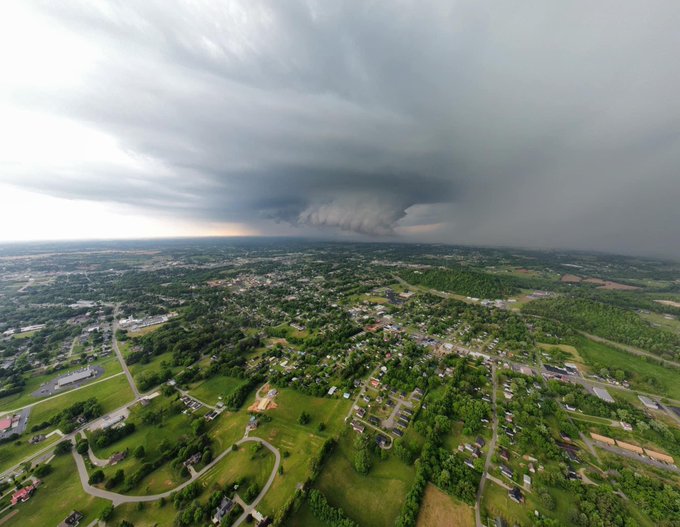
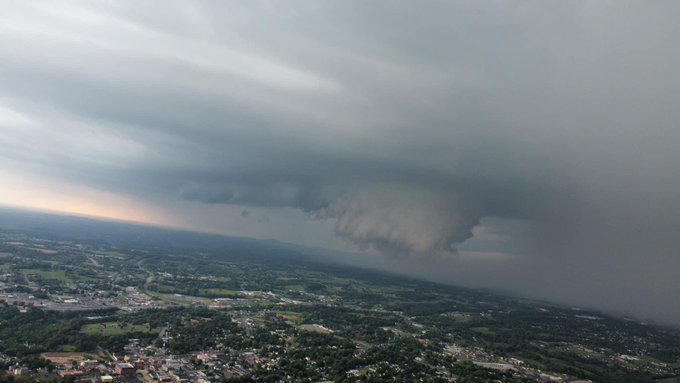
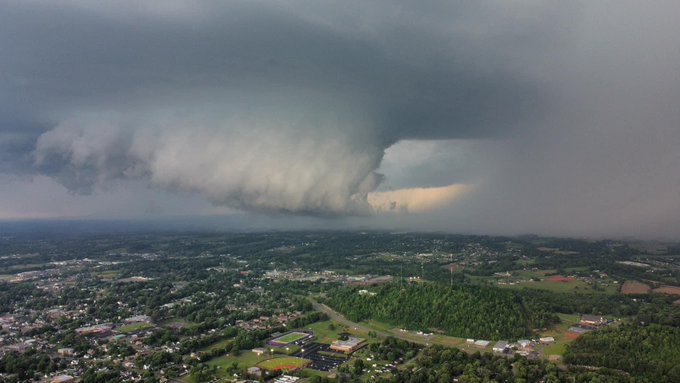
This is wild! Take a look at this severe warned storm as it arrived in downtown Lexington. It's a remarkable video of the shelf cloud and gust front along with its dynamics followed by the buffeting of the winds that officially hit 55 mph.
#lex18stormtracker
8
19
77
TV wife comes home!

@NancyCoxLex18
returns to
@LEX18News
Sept. 10 at 6 p.m. Glad to have her "back"
@BillMeck
@kevinmcguffey
@leecruse

3
5
47
6
3
74
A solid 1.5" at Stately Meck Manor this morning. And the driveway is shoveled (actually love shoveling!) Parents always joked that had me for 2 reasons, mow grass and shovel snow (and I enjoy mowing too).

4
5
70
Wanted to post this...check the barometer reading. This is only the 3rd time, and the first since 1978, that Lexington's barometric pressure has dropped below 29.00". We've had a near hurricane force gust in association with this powerful storm. And yes, the Sun is out!
#kywx
8
16
65
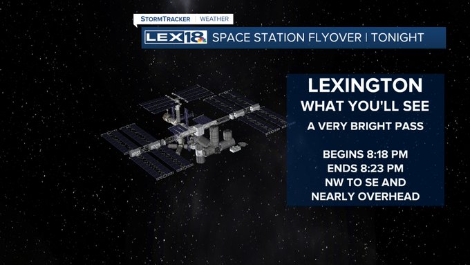
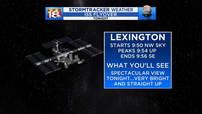
The International Space Station will be making a spectacular pass over the Bluegrass this evening. Starting at 8:18 and lasting until 8:23 the ISS will go from NW to SE and be almost directly overhead. It looks like a big bright fast moving 'star'.
#18StormTracker
#kywx
14
11
67
Well congratulations to all of us, we survived 22:22:22/2/22/22
See y'all in 11 years for 3/3/33
1
9
62
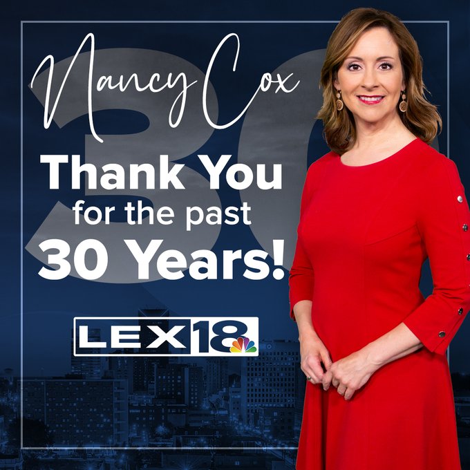
A big congratulations to my 'TV wife'. We've sat next to each other for 23 of your 30 years here. I could think of no one I'd rather share that time with. I look forward to many more. Cheers to you on what is now officially "Nancy Cox Day" in Lexington.
IT'S TIME TO CELEBRATE!! Please join us in congratulating Nancy Cox on 30 years here at LEX 18!!! 🎉🎊🥳
We love and appreciate all the hard work Nancy puts in to help make LEX 18 the best! ❤️
9
10
263
2
3
63
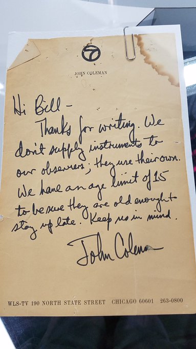
In a previous tweet regarding the passing of an industry giant, John Coleman, I mentioned that I have a hand written note from him from when I was 9 and wanted to be a weather watcher for him. I was able to show him this note in my 1 meeting with him in 1990. Note is 45 years old
6
0
62
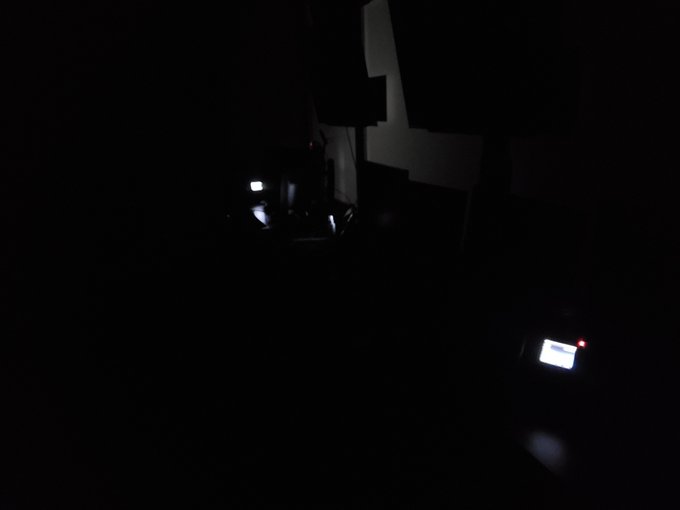
This is the current view in our studio...station wide power failure.
11
7
61
Lexington officially measured a wind of 70 mph yesterday...may be a top 3 wind gust ever recorded in Lexington...85 mph in 1948 as a tornado went through Keeneland and 72 mph in 1918 when wx office was downtown. Friend at City Center downtown had 100 mph on top of the crane!
1
28
57
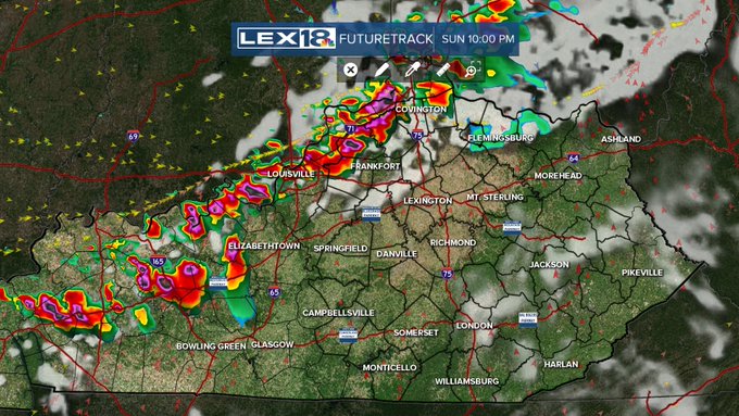
We're on the edge of a significant severe weather outbreak tonight. The highest risk will be just to our northwest, but it's close enough to Stay Weather Aware late tonight. Have an information source that can wake you handy and know your severe weather plan
#18StormTracker
#kywx


2
17
61
The severe threat has essentially ended. There are no watches or warnings in place . Current storms should be sub-severe. The evening warnings were essentially on the edges of where this morning's storms ended, so it did its job of stabilizing the atmosphere
#18StormTracker
#kywx
3
6
60
The first time I ever had a Spalding was Derby Day more than 20 years ago. Introduced a couple of our new reporters to the joy of Spaldings this morning.

The Derby party can officially begin now.
@BillMeck
has Spalding’s donuts.
#LEXAtTheDerby
@LEX18News

4
5
113
6
4
58
congrats to the UK women's volleyball team...Bringing the hardware back to Lexington...GO BIG BLUE
@KentuckyVB
#nationalchamps
0
1
57
The tornadoes of last night are historic. The number of deaths will tragically pass the numbers from the Super Outbreak of April 3, 1974 and be much more than March 2, 2012. The track length of the Mayfield tornado may pass the historic Tri-State Tornado of 1925.
#kywx
3
20
54
A Big Blue grad has flown in and coordinates the flyovers of Kroger Field. You'll meet him tonight on
@BBNTonight
and BBN Gameday tomorrow statewide.
0
7
54
We've enjoyed great gameday weather for our first 3 home games, but now it's the big one, Florida. The weather may not be perfect, but a lot of the day will be good. Still a shower chance late day/evening can't be ruled out. Go CATS!
@BBNTonight
@BBNGameday
@LEX18News
0
9
53
If you're wondering how far you can see on a clear day, well we're giving you something of an answer. From 400 feet up in downtown Lexington you're seeing a 30,000 foot thunderstorm in eastern Knox County almost to Pine Mountain...about 90 miles away. The more you know...
#kywx

1
6
52
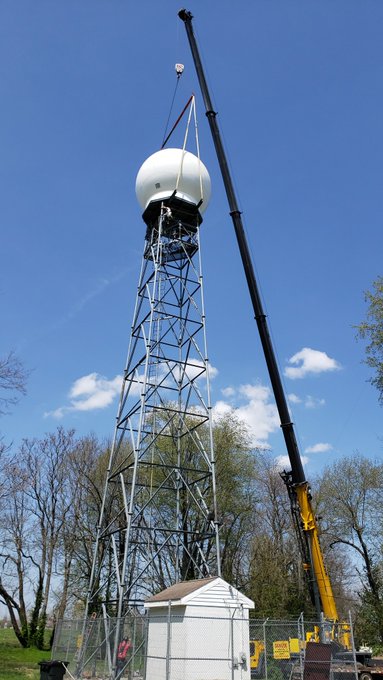
New Doppler ball is up! A few more days and Maxtrack 2.0 will be born! And don't worry, we won't be subtle when it comes time to debut it! 😉😀
3
3
52
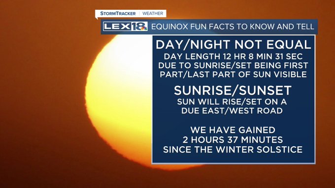
Today is the vernal equinox...the astronomical and official beginning of spring. The equinox occurs at 11:33 this morning when the Sun will be directly over the equator. For us, it'll be a terrific opening to the season with a lot of sunshine and a warm afternoon near 60.
#kywx
1
15
51
We always talk about weather keeping a balance. There's been no better example than this week. From Sunday's -7 which was about 25 BELOW normal and 5th coldest Jan 21, to today's 63 which is 20 ABOVE normal and the 6th warmest Jan 25. A 70 degree swing!
#18StormTracker
#kywx
5
7
50
The Storm Prediction Center is keeping all of central and eastern Kentucky in a Moderate Risk for Severe. The greatest threat looks to be in the SE where it has been quiet so far. However, airmass recovery areawide should lead to more storms later today.
#18StormTracker
#kywx
4
8
50
As we watch the continuing evolution of this winter storm, the threat is changing to a solid wintry mix of freezing rain, sleet and snow for the rest of tonight. Thankfully we won't see the high end freezing rain and ice totals, but roads are becoming ice covered and slick.
3
7
49
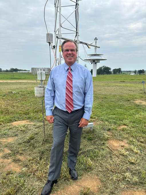
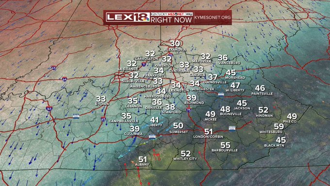
We talk about the
@kymesonet
a lot and talk about its value to us on a daily basis. If you ever wondered what one looks like, well here you go. At the dedication of the new site in northern Fayette county off of Ironworks Pike.
0
3
49
Sometimes you just have to go with it on live tv. Great work by our chief videographer Brian Stahl.
"Why did the deer cross the train tracks?"
Here's something we didn't expect during
@BillMeck
's live shot! 🦌
2
6
52
5
6
49
The setting sun looks like a nuclear explosion with the thin clouds tonight. Absolutely beautiful. This from our WeatherBug camera in Nicholasville.

2
5
49
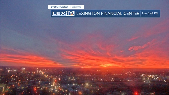
We are high atop Lexington on the 30th floor of the Lexington financial center (the big blue building) . I’ve been here on a clear day and you can see Jeptha knob in Shelby county. Today with the smoke you can barely see the water tower on new circle at Leestown. Amazing!

4
16
48
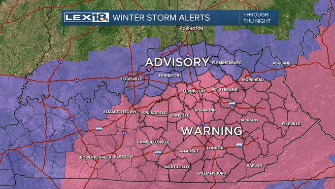
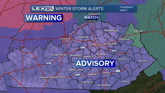
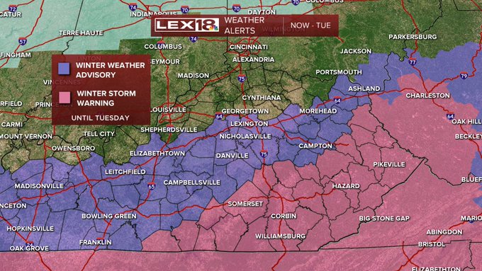
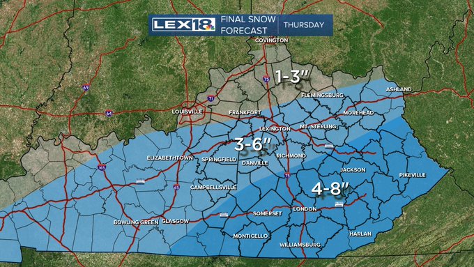
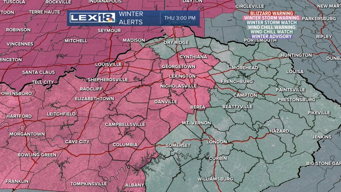
The Winter Storm Warning has been expanded north and west and now includes Lexington and surrounding counties east and west. The amount of snow expected has increased for tomorrow which triggered the expanded warning. Travel will become difficult Thursday afternoon/evening.
5
19
47
How about this...we caught both ends of this rainbow which starts around Bryan Station and ends at the old Herald Leader building at Main/Midland in downtown Lexington...way cool! btw Wait for a sec for the video to move.
@WeatherBug
#kywx
3
9
44
Incredible video from Frying Pan Shoals, about 40 miles south of North Carolina. Certainly a unique perspective and also begs the question...We can watch live video from 40 miles off shore with a hurricane, but I can't load a web page at Kroger Field.

The American flag is weathering Hurricane
#Dorian
just like it did during
#Florence
in Frying Pan Shoals, NC.
#18StormTracker
@BillMeck
@LEX18News
2
6
24
2
1
45
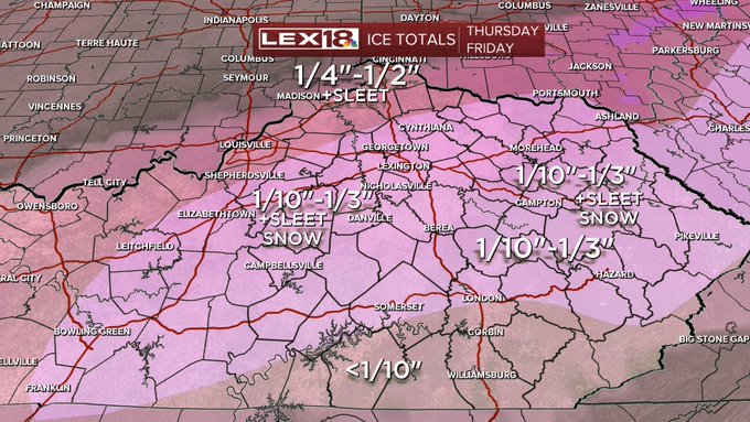
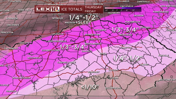
The Ice Storm Warning continues for later today and tonight. Some small changes to our forecast, the changeover in Lexington will likely now be late afternoon with roads icing up late day or early in the evening. Also, we're shaving the amount a bit, 1/4-1/2" for many, less south
2
7
45
Go Cats!

New career high, player of the game, and SEC all tournament team...what in big blue DOMination??
#banneralert
#BBN
#GOCATS

4
333
789
1
8
44
absolutely remarkable pictures from a drone near Somerset about an hour ago

1
13
44
just shoveled about an inch and a half from the driveway at Stately Meck Manor
2
2
45
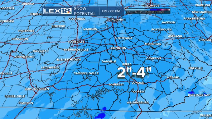
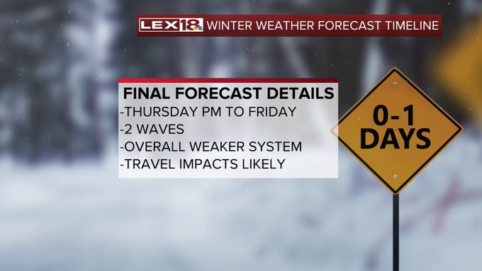
The probability of a major winter storm continues to grow for most of Kentucky Thursday into Friday. We're looking at the increasing likelihood of significant amounts of freezing rain and ice. Travel and infrastructure disruptions are possible Thursday into Friday.
#kywx

4
15
44
It's always amazing and uplifting when Dr. McCorvey sings and leads the Anthem at Kroger Field. The way he gets 60 thousand people to sing along and together is incredible...and you're right Eli, chills.

0
2
44
A beautiful near conjunction of Venus (the lower brighter one) and Jupiter this evening as seen from our
@WeatherBug
camera. Take advantage of the mild evening to get a look at this celestial event...and catch the waxing gibbous moon out there as well.
#kywx
8
4
43
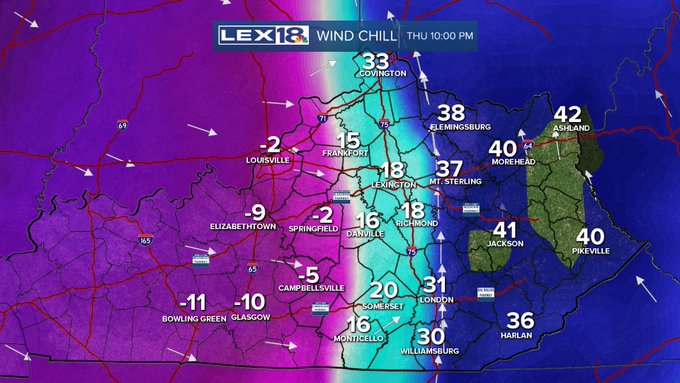
We've got an amazing cold front coming through Thursday evening. We have Snow Advisories for 1-4 inches of snow. Wind Chill Watch for chills to -30 and gusts to 45 mph. The transition will be remarkable mid evening as temps plummet. Lots of weather! STAY WEATHER AWARE
#kywx

2
10
41
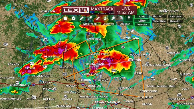
Twitter is no longer automatically posting warnings, so they may be sporadic here this afternoon. Stay Weather Aware and have either our on air feed or the StormTracker app handy. Severe storm is near 460 east of Georgetown. Tornado Watch in effect
#18StormTracker
#kywx
2
8
43
We've been getting a lot of calls tonight about seeing the Space Station. Clear sky permitting the Space Station will be passing almost directly overhead tonight beginning at 9:50. It will be very bright making for a spectacular reason to go out and look up on this warm night.
6
5
42
It was an amazing Christmas as record highs were tied or broken throughout Kentucky. Lexington tied the 40 year old record of 70. We did peak today, but even tomorrow, which will be about 10 degrees cooler will still be 15 degrees above normal. The warmth will last to about 2022.

2
5
41
STAY WEATHER AWARE late today and tonight. Updated info from SPC shows a bit of an east shift, and an enhancement to the wind threat. The whole area has a svr threat, these maps show the significant threats. Not a certainty, but severe storms are likely
1
9
40
OK...we can play some Lexington TV station weather roulette here... 3 out of the 4 local stations (18, 27 and 36...sorry 56) are currently represented on the 3:00 observation...just thought it was cool. May also be time to go buy a lotto ticket!
#18StormTracker
#kywx

6
3
40
The Arctic air has settled in and with it comes the 3rd storm in the sequence that started early this week. Snow totals through Monday will be higher south and east with a VERY SHARP cutoff north and west. Winter Storm Warnings S & E and Advisories south of 64. Stay Aware
#kywx
0
8
41
Nothing deep or Earth shattering here...just a beautiful sunset to share for 15 seconds. Enjoy the rest of your warm summer night and get set for the heat and humidity tomorrow (along with an early storm chance)
#18StormTracker
#kywx
1
5
41
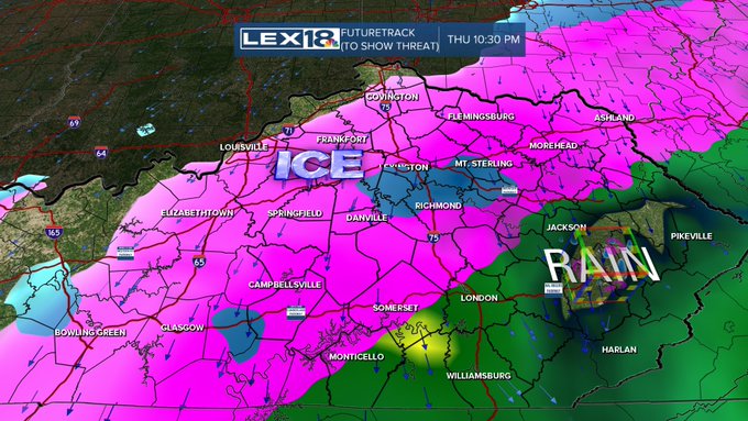
Rain develops Wednesday lasting through Thursday. By Thursday afternoon and evening pressing Arctic air at the surface may change the rain to freezing rain. Significant icing is POSSIBLE in the Ohio Valley. Stay with LEX18 as we focus on the storm details later this week
#kywx
10
10
36
Driving towards Jacksonville, Fl for noon live shot - my first hurricane... should be interesting
#18StormTracker
#HurricaneMatthew
9
9
37
Friday is a Stay Weather Aware Day. We have a High Wind Warning with winds likely in excess of 60 mph. Severe weather is also a high probability tomorrow afternoon with damaging winds a strong bet. Tornadic storms will also be possible. Heavy rain is likely tonight.
#kywx


3
18
39
The devastation of western Kentucky from the tornadoes has changed the lives of so many Kentuckians. Join
@NancyCoxLex18
and myself along with members of UK Athletics and Big Blue Nation as we host a telethon from 4-8 on
@LEX18News
Also, You can click the QR code to donate
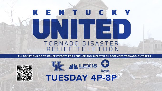
0
11
38
well that was interesting...there have been at least one report of sleet/graupel (and since it was from my wife I'll consider that reliable :-) ) and now it just thundered here at Stately Meck Manor...cool way to get a December week going

12
4
39
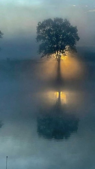
maybe one of the most beautiful pics we've received!

2
2
38
We've been watching new data coming in tonight and it's been coming in a bit more robustly with the snow potential. It still looks like most folks will be around a couple of inches, but with the Arctic air there may be some higher ratio snow leading to some higher totals.
#kywx
2
10
38
ICE STORM WARNING..rain tonight changes to freezing rain starting tomorrow morning from northwest to southeast. Significant ice accumulations are likely with disruptions to travel likely and power grids possible. The storm will be peaking Thursday night and ends Friday.
#kywx
4
17
35
@MarcWeinbergWX
it's actually gotten to the point that when I'm saying there is a tornado warning that, 'this isn't your signal to go to the porch to get video...get to your safe spot'
6
1
38
New data continues to come in tonight and the trend has been to increase some of the snow amounts. The Winter Storm Warning has extended into Lexington and surrounding counties with an overall increase in snow amounts possible tomorrow. Travel will deteriorate afternoon/evening.
2
7
37
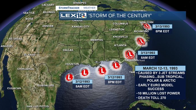
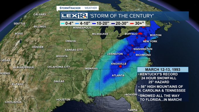
Hard to believe it's been 30 years since the 'Storm of the Century'. I was working in Roanoke for that storm and we had just started getting the European forecast model and it did amazingly well. For anyone under 35 it's just history, but for us older folks, it was incredible.
6
7
37
After our little brush with winter Saturday morning, the pattern gets REALLY active. The first storm Tuesday is a warm and WINDY one, but with time, true Arctic air is building with anomalies in Montana more than 40 below normal in about 10 days. Buckle Up!
#18StormTracker
#kywx
1
9
37
Thank you Governor! Just as a heads up there will be a special Red Kettle Event this Friday from 3 to 7 at the Lexington Wal Marts.
@LEX18News
@WKYT
and
@ABC36News
will be having a mini 'competition'. Stop by and say, "Hi" and drop a few dollars in.
@salvationarmy

Governor Andy Beshear rang the bell outside the East Frankfort Kroger today to raise awareness of the Salvation Army’s Red Kettle campaign.
This Christmas, the Salvation Army will help 400 kids in Frankfort alone.
@LEX18News
2
3
48
0
5
37
It's a big day at LEX 18. We welcome Larry Smith to the anchor desk and family. He's a seasoned professional and will be a terrific addition. I look forward to the day when we can actually all be around the same anchor desk.
@LarrySmithTV
@LEX18News
2
2
37
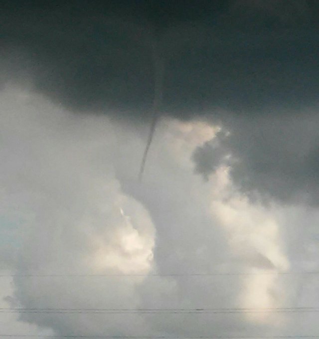
Here's a pic sent into us from Rowan County...perhaps there was a weak funnel cloud for that warning

3
8
35
It's officially sleeting at Kentucky's best tailgate. We may not be the brightest guys...but we are dedicated. Go big blue!
@BBNTonight
#GoBigBlue
#warmerbythegrill

0
5
35
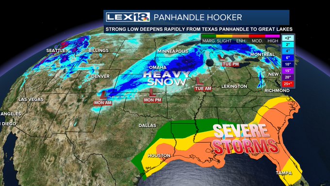
A powerful winter storm that's called a 'Panhandle Hooker' is marching through the nation's midsection bringing heavy snow and severe weather in the south. For us, it's a lot of wind with a WIND ADVISORY and gusts 40mph+ and heavy rain with over an 1" likely
#18StormTracker
#kywx

5
3
36
A change to the Winter Alert, but NOT a change to our forecast. A Winter Storm Warning has been issued for central Kentucky, including Lexington through noon tomorrow. Forecast area snow totals remain the same, 1-4". Eastern Kentucky remains in a Winter Weather Advisory.
#kywx
4
15
33
A Christmas tradition at Stately Meck Manor is reading Twas The Night Before Christmas. I've been privileged to also narrate it a few times with the Lexington Philharmonic. Tonight, our news folks allowed me to share this with you. Merry Christmas!

3
1
35
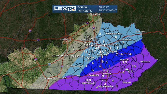
These are most of the snow totals received either by us or the NWS. We put the numbers on our forecast map. Gray was 1-3, lt blue was 2-5, dark blue 4-8 and purple was 3-6. Not perfect, but not too bad for what was a significant and complex storm. Please comment with your total.
14
8
34
what a remarkable way to show off one of the most beautiful places in the Bluegrass!

Thoroughbreds. Tradition. Beauty. Racing as it was meant to be.
A unique look around
@keenelandracing
, host of the 2022 Breeders' Cup World Championships.
#BC22
14
93
357
2
3
34
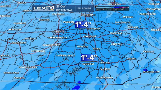
The next wave of winter weather is on the way. An Advisory is up for the area Thursday PM into Friday. For most of us, it's a 1-3" snow by the time it's done Friday. Some ice may mix Thursday too. Some travel impacts will be possible, especially Friday AM.
#18StormTracker
#kywx


1
6
33
holy cow!

WOW!! These are some extreme blizzard conditions in Cheyenne, Wyoming on Wednesday evening! The temperature was 18 degrees below zero.❄️🥶
#winter
#blizzard
#knowbefore
1
3
29
0
3
32
It's still a sleet/freezing rain game in Lexington with snow now moving through Frankfort and Georgetown and heading east. Continue to expect bad roads/worse roads all through the night.

7
10
32
@bigkat859
As I'm still hoping to maintain my eligibility getting into the Weatherguy Hall Of Fame, I can't make wagers or comment on weather I may be involved in.
1
1
33
and if you did go out and look up for the ISS flyover, Venus is absolutely stunning and the moon is nearly full...ENJOY!
0
1
30
amen!

Just going to leave this here as we head into the weekend portion of the tournament.

9
35
95
5
6
33
Tonight and for the next several weeks it's easy to spot big and bright red Mars. Tonight it's just to the left of the Moon. This is the best look at Mars since 2003. Jupiter is also visible to the right of the Moon. It's always great to look up!
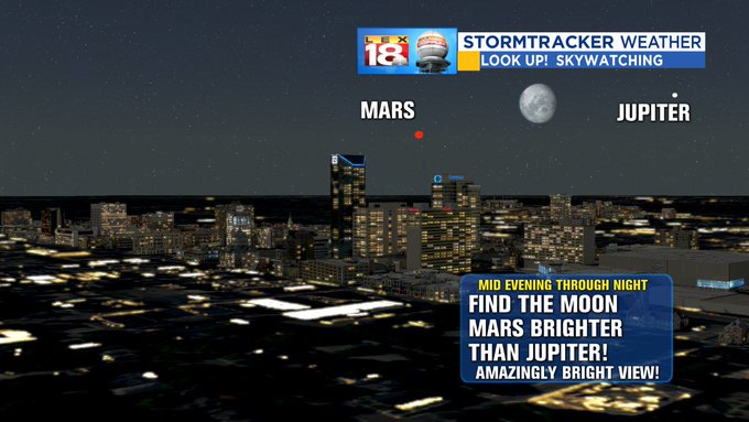
1
5
30
During last night's violent thunderstorms it peaked with a large macroburst wind in Madison Co. A macroburst is a large downburst that spreads out after hitting the ground and must be over 2.5 miles wide. This had winds to 110 mph (same as top end EF1)
#18StormTracker
#kywx
4
12
33

It sort of looks like the Sun sent out a death ray. It was actually a break in the clouds that came with the gust front that produced a 45 mph gust at the airport about 5:45 today. Just looks interesting.
@WeatherBug
#kywx
0
5
30
gustnado or cold air funnel over eastern Fayette County about 6:25. Harmless but still really cool to look at.
@LEX18News
2
16
31