
wxKobold
@wxKobold
Followers
2K
Following
466
Media
5K
Statuses
8K
Not degreed, just hobbyist. I like to study storm behavior and torgen. Lightning addict. Live west of STL. Aerospace guy. bsky handle @misocycl.one
Saint Louis, MO
Joined March 2021
https://t.co/2P7zugxSqq Since I get asked so often, I decided to make a quick guide on making storm-relative/storm-following radar loops w/ GR2A v3 and ScreenToGif. LMK if I need to clarify anything or make any changes! #wxtwitter #radar
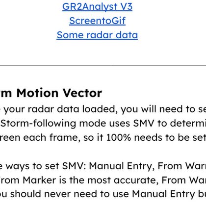
docs.google.com
Making Storm-Relative Loops A step by step guide by @wxkobold You’ll need: GR2Analyst V3 ScreentoGif Some radar data Step 1: Storm Motion Vector Once you have your radar data loaded, you will need to...
5
5
34
These streaks are always really interesting -- we see discrete streaks of inbound/outbound velocities which usually indicates some sort of horizontal rotor/vortex. I always wonder if they're hairpin vortices (or otherwise related to low speed streaks in fluid flow).
0
0
7
Some more track updates in the MOB area! This time, an EF2 (EF3) track through southern MS. Looks like extra detail was added to the track, which now shows a bit of trochoidal wobbles. These are also visible from radar, where we can almost see at one or two points it cycles a
1
1
16
Man, twitter mobile is stupid. I sent this tweet at like 8AM on my phone and it just now sent 17 minutes ago. I thought it failed so I tweeted another set of pictures. Oh well
0
0
1
Wow I've never had a sunrise that was so bright orange that my phone was auto balancing the orange out! Insane way to start a Friday.
1
1
6
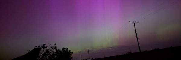
St. Louis was graced with a ridiculously high end sunrise this morning! One of the fieriest sunsets I've seen in a really long time. The sky was absolutely glowing fiery orange -- the orange got so bright that my phone started filtering it out (last pic) by adjust temp!
0
0
4
Separately, LOT has touched a LOT of EFU damage lines today -- likely changing them from "UNKNOWN" to "EFU" due to a DAT glitch that was messing up the display of EFU tornadoes for a a bit.
0
0
5
Daily (extremely) minor DAT updates: A single damage point from the St Louis EF3 from 2025/05/16 has been upgraded from EF0 to EF1. Meanwhile in MS, damage points from 2/10/2011 have moved approximately 150 feet.
3
4
66
If anyone's curious, the entire dataset (radar volumes) of tornadoes (all of them) on NEXRAD between 1991 and the end of 2019 fits nicely onto a 4TB hard drive.
0
0
9

🐦⬛Our C-band radar in Senegal captured a bird flock takeoff. ZDR varied with flight direction: up to +5 dB for birds flying toward/away, near 0 dB when flying sideways. Why? Flapping wings look wider from the front, but more symmetric from the side.
0
1
12
Currently running a script to download *all* the tornado data from NEXRAD. Every single report in the NCEI database, I'm grabbing a data timeframe that includes start/end time. Currently I've made it from 1991 to 2016... Currently sitting at nearly a million radar volumes
2
1
10
More daily minor DAT updates! 1: The tornado north of Bennett, CO from 2025/05/18 seems to have had a path refinement. 2: Next, down in MS, this 2014/04/28 EF2 south of Shubuta seems to have had its path refined quite a bit. (smells like NWS MOB doing their thing again!)
2
1
31
Outside my normal realm of cats and radar data, but... Managed to find an eagle near the house and took out the zoom lens for a very small photo shoot! Autofocus failed me slightly but I got a couple decent shots!
0
0
4
Short loop and a couple stills of the unwarned (probable) tornado that passed by the KBOX radar site. Velocity is pretty indicative of a QLCS spinup, and CC seems to confirm SOMETHING is being lofted (quite a lot of it). However, I don't expect this to be a particularly strong
0
3
10
Appears there may have just been an unwarned tornado (with possible TDS) northwest of Taunton, MA.
0
1
10
And just like that, the "EF5 drought" was over. Shown is the full birth to death loop of the supercell that produced the Enderlin, ND EF5 tornado. Much shorter than my usual full storm loops are, this storm had an INCREDIBLE amount of help from the squall line overrunning it.
2
14
187
Kansas NWS offices seem to have added damage polygons to 4 tornadoes from 2025/05/18 in the past 8 hours or so.
2
1
46
I know everybody's excited for the drought breaker, and I am interested to see how this affects future surveys? Now that one office has "done it", will other offices be more willing to be bolder with surveys and be willing to add higher wind speeds to non-traditional DI's? We
0
1
8
In a (likely futile) attempt to not be shown up by NWS Grand Forks, NWS Aberdeen has added SEVERAL new wiggles to the Gary, SD track!
1
7
90
Delta-VWP loop of the dataset that includes the Enderlin, ND EF5 tornado. Not an ideal setup for a useful VWP loop, though seeing the squall line come in like a freight train (perhaps one being tossed through the air) is cool!
0
5
39