

wralweather
@wralweather
Followers
181,473
Following
850
Media
5,039
Statuses
37,778
NC's most trusted source for weather. WRAL's 6 meteorologists tweet #ncwx forecasts, warnings, hurricane updates & more. Apps:
Raleigh, NC
Joined August 2008
Don't wanna be here?
Send us removal request.
Explore trending content on Musk Viewer
Rafah
• 1328043 Tweets
井上尚弥
• 276524 Tweets
Inoue
• 162781 Tweets
Stray Kids
• 125192 Tweets
RPWP IS COMING
• 82375 Tweets
ボクシング
• 70517 Tweets
#رفح_تحت_القصف
• 44047 Tweets
モンスター
• 38671 Tweets
Bruno Mars
• 36326 Tweets
#MetGala2024
• 29163 Tweets
Kim Namjoon
• 29024 Tweets
GW終了
• 27191 Tweets
井上選手
• 26673 Tweets
逆転3ラン
• 24972 Tweets
筒香のホームラン
• 21905 Tweets
20 YEARS OF MINJI
• 20200 Tweets
AESPA SUPERBEING TEASER 1
• 18511 Tweets
#GWを写真4枚で振り返る
• 18360 Tweets
Białoruś
• 17710 Tweets
Bernard Pivot
• 16036 Tweets
MIOTO NO VENUS PODCAST
• 15923 Tweets
#MIvsSRH
• 15143 Tweets
#VurPençeniKupaya
• 12723 Tweets
#Superman
• 11166 Tweets
横浜優勝
• 10044 Tweets
David Corenswet
• 10011 Tweets


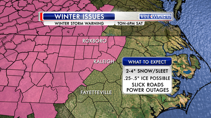
Winter storm warning goes into effect at midnight tonight. Be ready to stay home tomorrow.
#wral
22
656
552
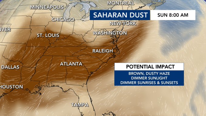
The latest Saharan Dust Model shows the dust making its way into North Carolina this coming weekend. If current trends persist the dust appears substantial enough to dim our incoming sunlight. We will follow this all week.
@WRALWeather
55
285
539


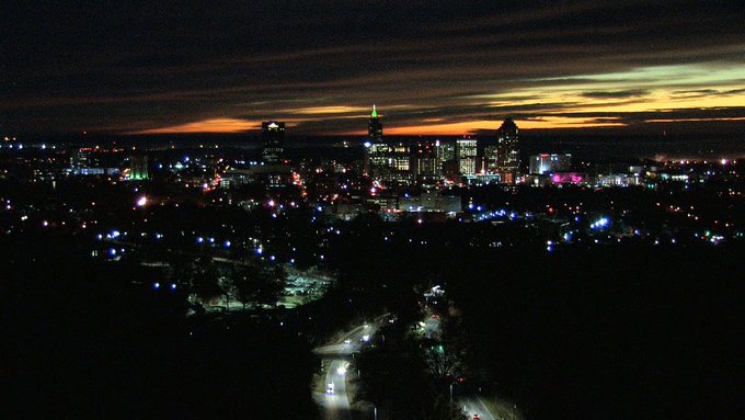
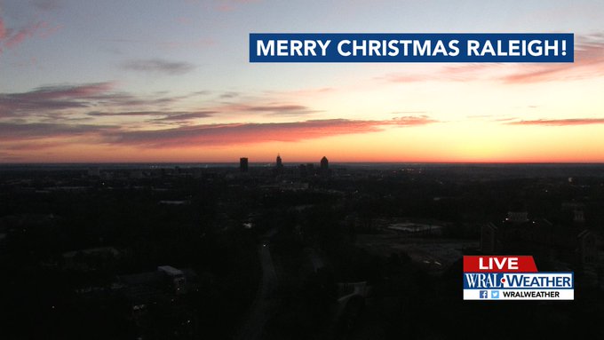
Pre-sunrise view of downtown Raleigh this Tuesday morning rates as pretty much postcard-worthy!
0
33
112
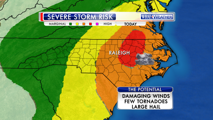
An unusually high threat for severe weather today. Expect wind damages and a few tornadoes.
#wral
0
134
99
Are you seeing the creepy orange sky this evening? The setting sun is hitting the base of the clouds lighting them up in orange. Very cool.

7
4
102
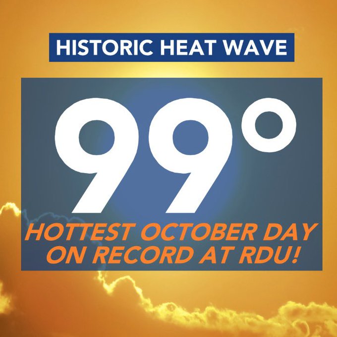
Update: we hit 100 at RDU
Today is officially the hottest October day on record at RDU airport with a high of 99° as of 1:16 PM. This also breaks the daily high temperature record for today. This ties for the hottest day so far this year at RDU!
2
2
22
6
31
78
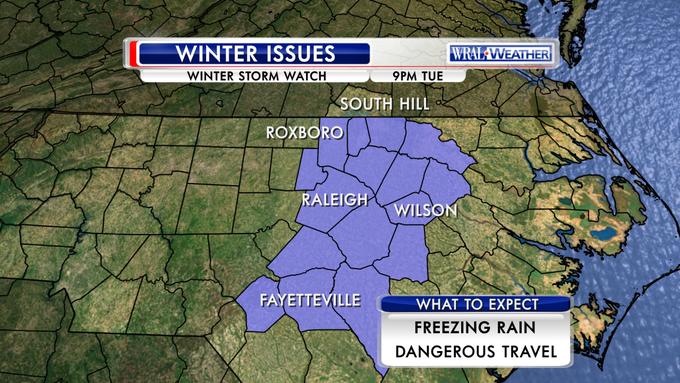
Rain this morning changing to a mix late today. Winter Weather Advisory in effect at 3pm. Slick bridges tonight
#wral
http://t.co/B2sZQBgJJb

4
53
70
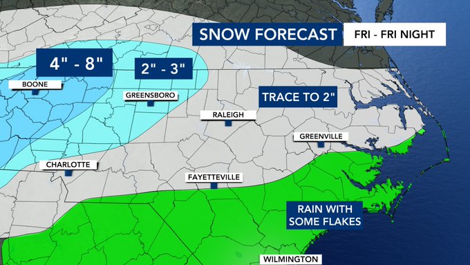
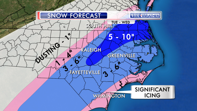
We shifted the snow totals farther south and east as the upper level low should move from west to east across the state depositing some snow. Remember the track of the upper low will dictate the snow swath and totals.
@WRALWeather
6
21
70
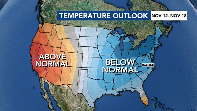
The Climate Prediction Center outlook for the next 8-14 days shows well below average temperatures. We are expecting January like temperatures this weekend, and next week, break out the winter clothes.
3
18
70
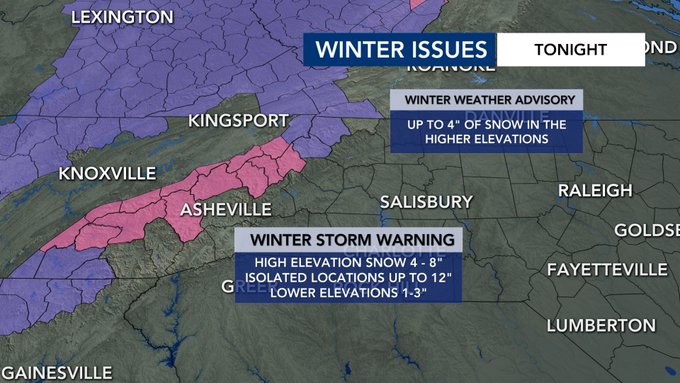
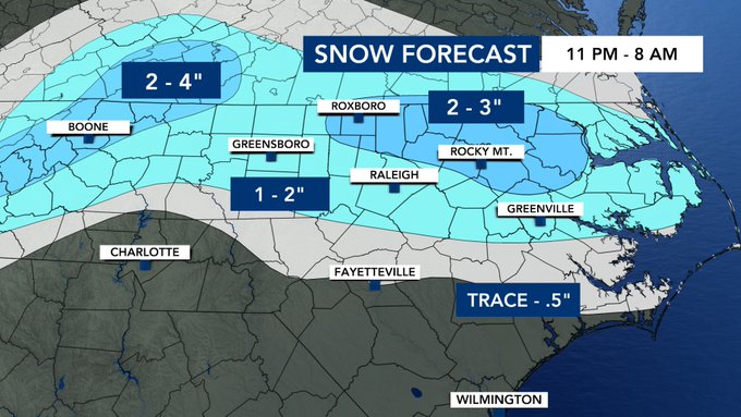
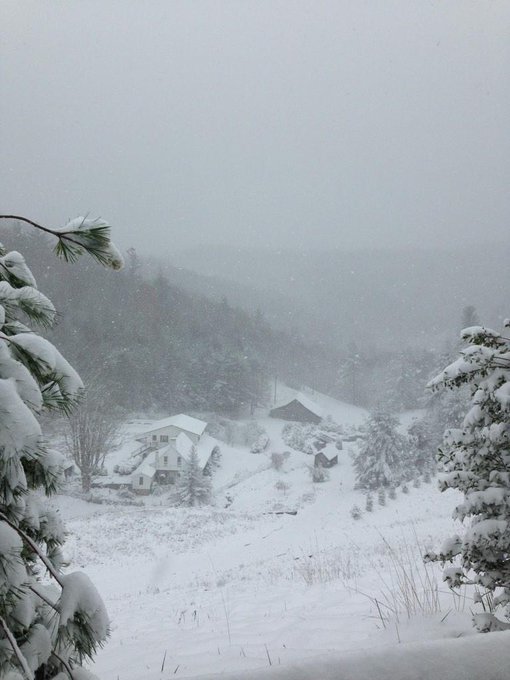
Snow is falling in the mountains this afternoon with more to come. The heaviest snow will fall in the Winter Storm Warning area. Boone area should see up to 4" in spots. Wish I could take a road trip!
3
12
71
5pm update: Most likely, boom, and bust scenarios. Starts 8-10p as rain, changes over to snow for many.
#ncwx
http://t.co/cV5w4WA12y
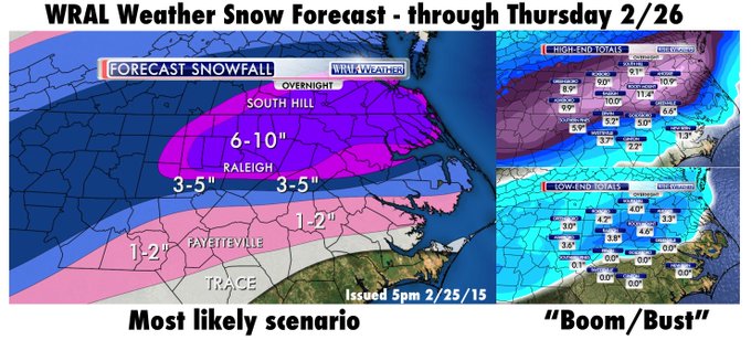
9
124
59
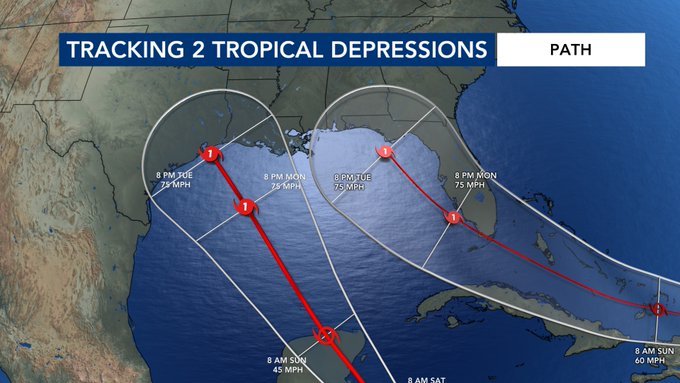
We could be looking at two hurricanes making landfall at the same time next Tuesday night along the Gulf Coast. We have never seen this happen before. This of course is if the forecasts are correct. Things could change between now and next Tuesday.
8
29
60
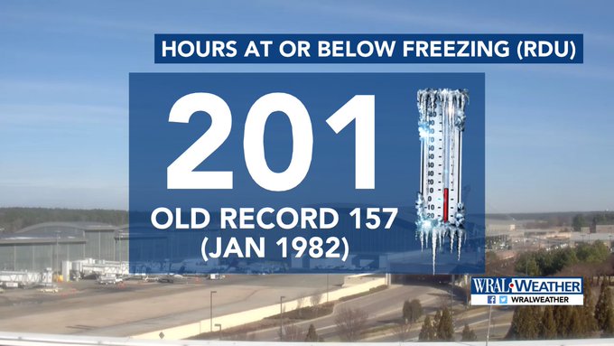
The record streak at RDU has mercifully ended, as a 31 degree temperature at 10AM (the 201st consecutive reading at 32 or below) was followed by 37 degrees at 11AM. We ran way past the old 157-hour record, which ended on January 16, 1982.
1
31
60
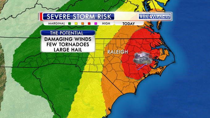
Storm Prediction Center expanded the level 4 (out of 5) risk of severe weather for us today.
#wral
4
77
58
JUST IN: Max sustained winds have increased to 150 mph with gusts to 175 mph in the new advisory. This is 6 mph below cat 5 status!!!

2
36
52
The snow guns are going at Sugar Mountain as the temperature has fallen below freezing. There's also real snow falling and will continue to fall tonight and tomorrow with up to 4" expected. Let it snow, let it snow, let it snow!
@WRALWeather

1
5
54
Our snowfall forecast for tonight into tomorrow as of 5pm Friday.

8
48
51
A very serious situation for us today. We are at a level 4 out of 5 risk for severe weather. Damaging winds and tornadoes are likely. Download the WRAL Weather App for severe alerts and turn on the tv for live storm tracking. Know your safe place.

1
40
53

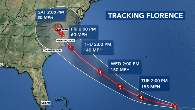
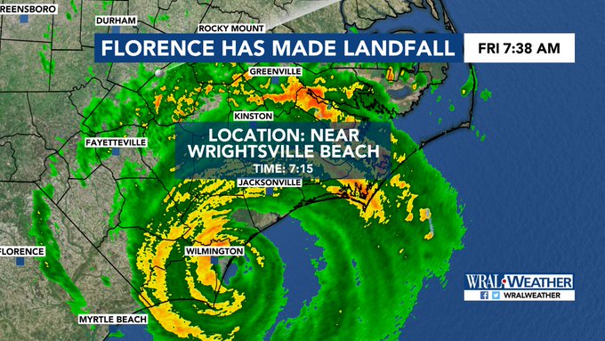
JUST IN: Here's the updated forecast track for Hurricane Florence. Florence is still forecast to make landfall along the Carolina coast as a category 4 hurricane. The size of the hurricane force wind field has doubled in the past half hour.
@wralweather
5
48
50
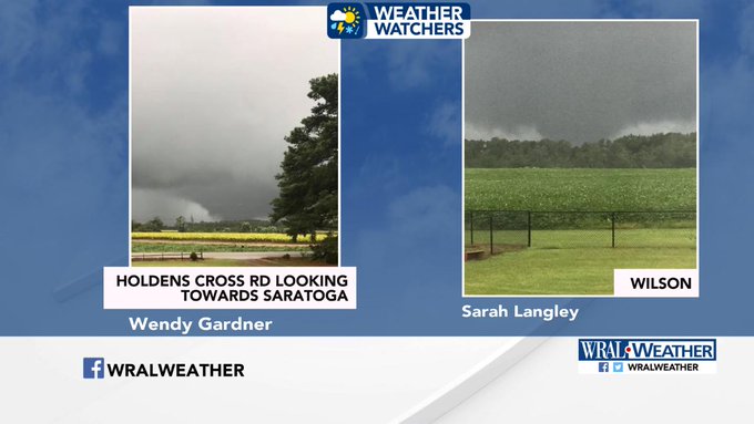
Our WRAL Weather Watchers sent in photos of what appears to be a Tornado near Wilson.
0
21
45
It's 22 degrees cooler in Roxboro today and 10 degrees cooler in Raleigh and Durham. Do you prefer cooler and cloudy or warm and sunny?

23
4
47
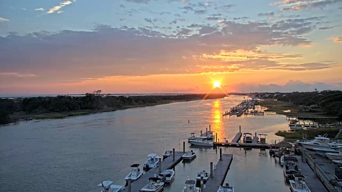
Raise your hand if this is where you'd like to be right now! The weather has been beautiful at the coast this week.
2
3
46
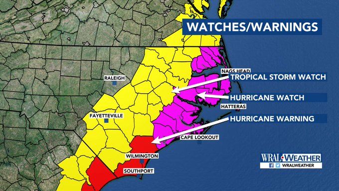
JUST IN: A Hurricane Warning has been issued for New Hanover and Brunswick Counties. A Tropical Storm Watch remains in effect for areas southeast of the Triangle in yellow. We are breaking down the impacts on WRAL News right now.
@wralweather
2
27
40
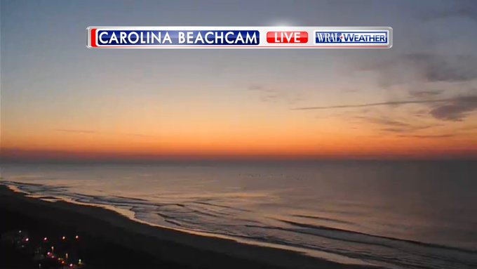
It's National Nature Photography Day! Let's see your best. Katie Merritt got this one at Carolina Beach!
#wral

1
7
45
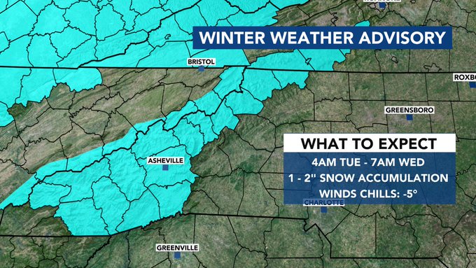
A Winter Weather Advisory goes into effect early tomorrow morning for most of the NC Mountains. This will be the first measurable snow of the season for most of the mountains. A few flakes could briefly mix in here locally but no travel impacts expected.
0
11
41
Snow in Durham!! Thanks Scott from the Bulls for turning on the lights for us! Turn on FOX50 at 10 and WRAL at 11 for your latest snow forecast town-by-town.

3
10
45
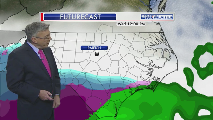
5pm SNOW UPDATE: Event looks to have shifted westward a touch. More snow Raleigh/Fayetteville, more ice Wilmington.
http://t.co/8m0P1QCUXD

6
139
44
Get ready snow lovers! This is our Friday afternoon snow forecast update. Looking good for sledding in the Triangle, Sandhills, and our eastern counties. Don't forget to share your snow photos and videos with us! Turn on WRAL at 4 to see when the snow arrives where you live.

5
9
41
YAY OR NAY? 2 to 4 inches of snow possible Monday night into Tuesday:
http://t.co/IPAb9Xpb7Z
http://t.co/4BWyAUMWVV

6
43
41
Snow coming down now from the triangle southward. Sticking in places.
#wral
#ncwx
http://t.co/ch2ACvAPH6
3
71
37
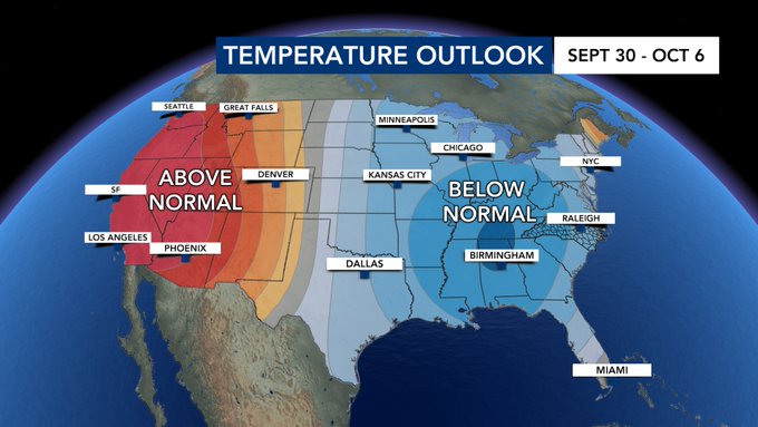
It now appears we have a greater than 50% chance for below normal temperatures for the first week in October. I think we are done with the 90s for the year.
3
6
39
Here we go again! The heat advisory goes into effect at noon. It will feel like triple digits until 8pm or so.
#wral
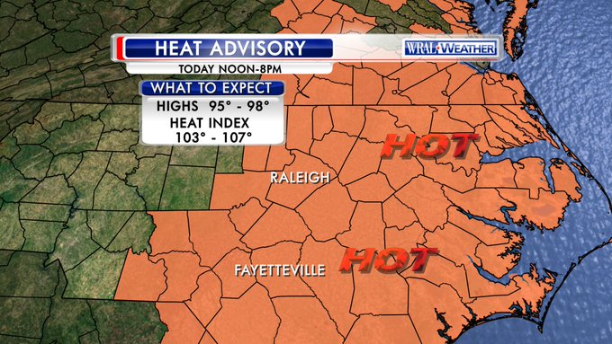
1
16
35
JUST IN: A Tornado Watch has been issued for Wake, Franklin, Harnett, Johnston, Nash, Sampson, Edgecombe, Wayne, and Wilson Counties.
@wralweather

0
35
40
Models still give a wide range of snow totals tonight. Still there's a good chance of high accumulation
#wralsnow
http://t.co/pQzqGAExvK
1
45
39
Here's our final forecast for the winter weather event overnight. The greater totals should be in our northern counties where the snow is expected to be the heaviest and last the longest. I think all of us should see some snow come down overnight.
@WRALWeather
3
12
39
PASS IT ALONG: There is a HIGH risk of rip currents at all North Carolina beaches tomorrow.

0
29
39
Wow talk about a Winter Wonderland, take a look at Grandfather Mountain this afternoon. They are well covered in ice and snow there. Gorgeous!

1
2
40
A peek at the weekend: Wet Friday night through mid-day Saturday. A little drier on Sunday.
#wral
0
0
34
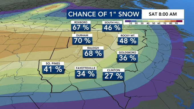
Probabilities for at least an inch of snow are growing for Friday evening into Saturday morning. Here's a look at the latest run of the European Ensemble Probabilities. Tune in starting at 10PM on Fox 50 for a deeper look at snow potential.
@WRALWeather
0
9
38
Look at the extent of the Saharan Air Layer that extends from Africa all the way to the U.S. Scientists say this is the most dust they have seen in 50-60 years! We will see some this weekend but the thickest dust stays to our south. An update at 6PM on WRAL.
@WRALWeather

3
21
35
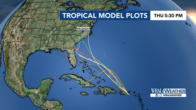
11 PM Update: Tropical Storm Michael is still forecast to make landfall along the Florida panhandle as a hurricane and weaken as it moves toward NC. Details after the game on WRAL.

2
20
36
Winter weather advisory for the entire viewing area until this evening
http://t.co/yevloxBNik
3
53
34

JUST IN: The NHC sent a 9am update for Dorian. Wind speed dropped from 120 mph to 115mph. Pressure came up slightly which is another indication that it is weakening slightly.
@wralweather
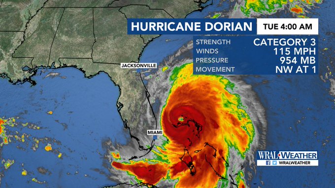
0
16
35
A freezing rain advisory is in effect starting at 7pm. Some light freezing rain poss., mainly after 10-11p for us.

1
38
36
Laura is a powerful category 4 hurricane with maximum sustained winds of 140 mph. Hurricane Laura will make landfall late tonight around or shortly after midnight with life-threatening winds, storm surge, and flooding expected. Turn on WRAL at 4 for updates as conditions worsen.
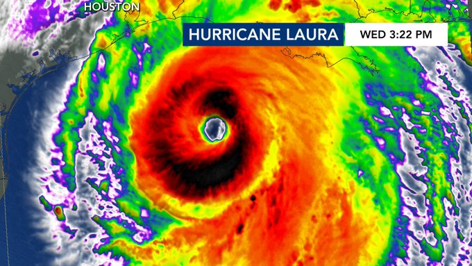
2
10
19
Here's a look at snowfall potential from some of the models we use in forecasting. It's feast or famine for snow lovers tomorrow night. We are trending on the lighter side in our forecast with some locations perhaps seeing up to an inch of snow.
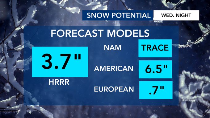
10
14
36
Here's the new forecast track for TS Dorian. It crosses Puerto Rico this evening and swings toward the US by late this weekend. Intensity increased to Category 2 as it approaches the southeast US. On tv we'll have more detailed information.
@wralweather
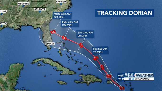
2
15
34
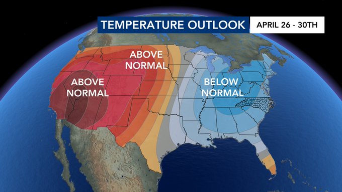
I don't know about you but I am a fan of the cooler weather we have had lately. Signs are this trend will last through the end of the month and possibly through the first week of May. Are you liking this cooler weather? I like the 80s but prefer them in May and June not April.
4
1
33
5PM: The latest forecast track from the National Hurricane Center is in and it has Florence strengthening to a major hurricane as it approaches the Carolinas. We will have halftime updates regarding Florence on WRAL and FOX50.
@wralweather

3
27
34
WRAL photojournalist Chad Flowers captured this pic of outer rain bands from Hurricane Arthur at Wrightsville Beach.
http://t.co/5AjN6RbOPS

2
37
34

What's that blue stuff about?? Yep, winter weather is possible Tuesday. Tune in to
@WRAL
at 11:46 PM for the latest..
http://t.co/sMf2GbVCEj

10
75
32

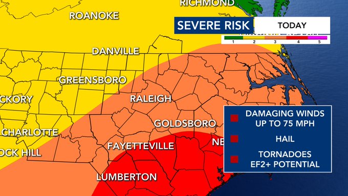
New This Morning: SPC adjusted the Severe Risk for this afternoon's storms. While the Level 4 Risk has shifted out of the Triangle, it remains for our SE communities. The biggest threat is still widespread damaging winds. Hail and a strong Tornado are still possible.
@WRALWeather
0
11
32
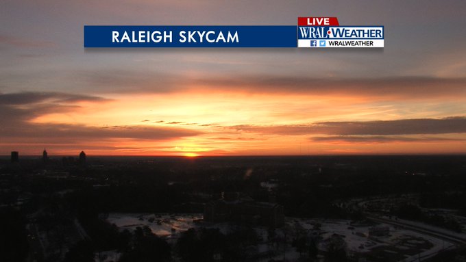
Here's your Monday AM tease. There are a few lucky folks on the beach enjoying this sunrise....not me.
#wral

0
10
30


The corridor of heaviest rain is likely to set up in our viewing area with 1-3" likely & gusts up to 30-40 mph. The wind gusts could be higher at the coast with gusts up to 45 mph but rain totals will likely be less than what we see here. Turn on WRAL News for the tornado risk.

0
12
29
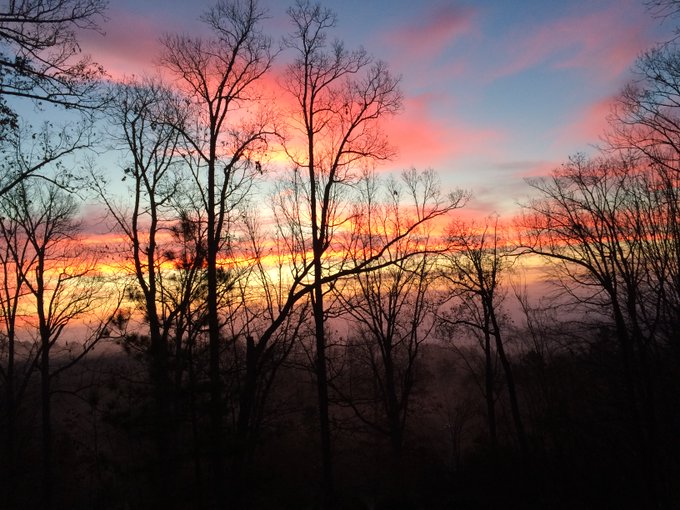
Tough to beat a sight like this! Gorgeous January sunrise - snow in the foreground and fire in the sky!
#wral
1
3
30
JUST IN: The 11 PM forecast track shifted north. Florence is still forecast to make landfall as a major hurricane in NC.
#Florence
@wralweather

2
29
27
Fishel: To people of faith, science is a gift. Let’s use it. To scientists, respect people of faith & they may listen.
#OfishelQuest
#wral
1
21
29
Here's where the rain/snow line could be around 5AM tomorrow morning. At this point most if not all of the area should be seeing some snow coming down. We think the atmosphere will be able to cool down enough to generate snow overnight!
@WRALWeather
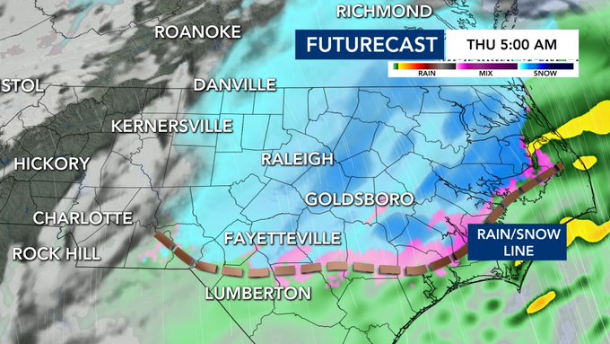
1
8
30
The fog in Raleigh is beautiful but be careful on your commute. Dense Fog Advisory thorugh 10am from the Triangle - east.
@wralweather
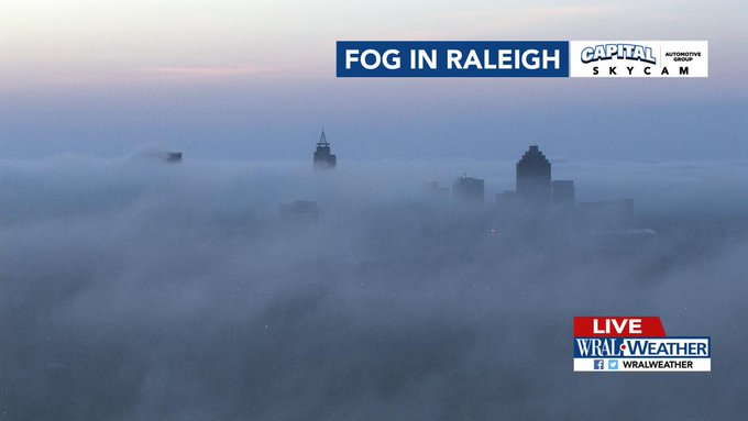
0
3
30
The 'hurricane watch' tweet that went out moments ago was in error. There is no hurricane watch. (1/3)
4
8
28
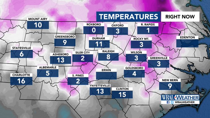
Temperatures at 4AM are bitterly cold, with RDU just dropping to 8 degrees to break the old record low of 9 from 2014. Roxboro has fallen to zero, and Roanoke Rapids is closing in.
6
16
30
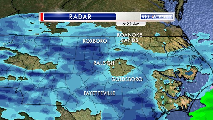
From our Tall Towercam you can see the heavy rain falling over Wake County this afternoon. We expect these showers and storms to remain in the area through this evening and perhaps overnight as well.
@WRALWeather

0
3
30
We've got a small potential for wet snowflakes Wednesday night into Thursday morning. Here's a look at the European Ensemble probabilities showing perhaps a chance for an accumulation in Southern Virginia. We will track this trend at 6PM on WRAL.
@WRALWeather
2
10
29
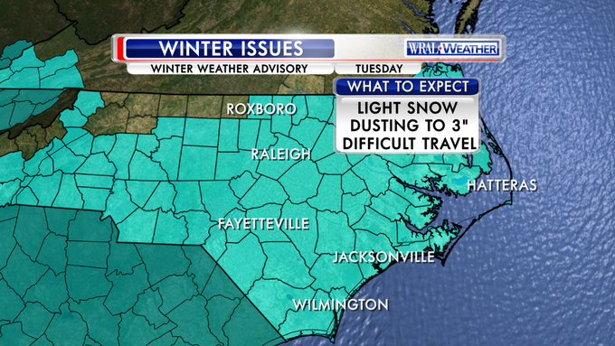
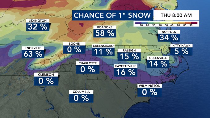
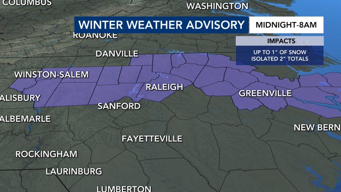
JUST IN: A winter weather advisory has been issued from the Triangle and points to the north. Rain will change over to snow early Thursday morning. Up to an inch of snow is possible with isolated 2" totals.
@wralweather
1
14
29

It doesn't look good for you to have a delay
@WCPSS
@ITBliving
Here's the noon outlook.
http://t.co/tRIEe5Twau
9
34
28
JUST IN: We have a level 2 threat in place for our southwestern counties today. Damaging wind speeds will be the main threat with storms. Coming up on WRAL News right now, we'll go hour by hour and time out storm chances on futurecast.
@WRALWeather

1
8
30
4
15
29
JUST IN: Dorian makes landfall on Elbow Cay in the Abacos as a catastrophic category 5 hurricane with maximum sustained winds of 185 mph and gusts to 220 mph. Potential storm surge there is 18-23' above normal tide levels with higher waves.

1
21
28
#Dorian
stays over open water instead of going over the mountains of Hispaniola. Now there is really not much to stop Dorian from strengthening as it moves toward the US coast.That is why Dorian is now forecasted to make landfall as a major hurricane.
1
16
29
Winter storm warning goes into effect at 4:00 for most of our viewing area. Some snow but mostly freezing rain.
#wral
http://t.co/tNcT170P8F

2
52
29
WRAL Snowfall Forecast... Final Pre-Storm Call. Snow's a bit late but it's coming. Big totals for some to the east!
http://t.co/IPi6PyhX0E
7
70
27
Fountain mountain in front of our WRAL studios is huge! It's almost twice as big as this time yesterday.
#wral

2
5
27
Check out the temperatures at lunchtime 60s, today will be the coolest day since June 12th.
@wralweather

0
3
27
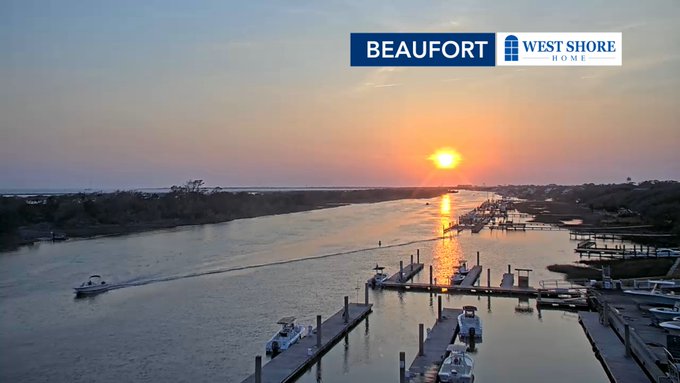
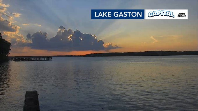
We have a new camera in Beaufort from the Beaufort Hotel to showcase how beautiful our coast is. The sun just set there and it is looking mighty spectacular in Carteret County.
@WRALWeather
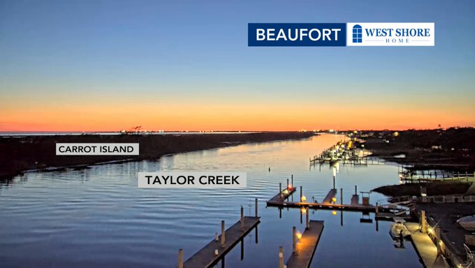
0
3
27
We would like to welcome Sanford to our growing list of cameras! So happy to have a camera in Lee County.
@wralweather

1
5
28
Conditions are starting to deteriorate along the NC coast this afternoon. Winds are now gusting to 59 mph at Beaufort and a buoy just off the NC coast recorded a 28 ft wave height.
#wral
#wralweather
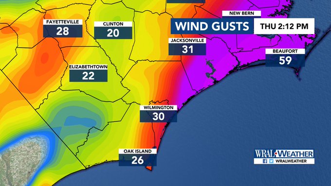
0
10
28
6 PM WRAL snow forecast. Little to no impacts are expected in the Triangle but slick bridges could be a concern near the Virginia border. A Winter Weather Advisory is in effect for Granville, Person, & Mecklenburg (VA) Counties. Look for an updated map tonight at 10.
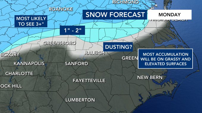
0
6
28

11pm update on Hurricane Florence: Max sustained winds up to 90 mph. Still forecasted to make landfall as a major hurricane along the NC coast Thursday.
#wral

3
24
24
The NWS has issued a winter weather advisory through midday Tuesday. Ice on roads will make travel dangerous.

1
28
25