Utah Geological
@utahgeological
Followers
9K
Following
351
Media
3K
Statuses
4K
The Utah Geological Survey (UGS) provides timely scientific information about Utah’s geologic environment, resources, and hazards.
Utah
Joined February 2010
Did you know the original Salt Lake City Hall is made from reddish-brown Nugget Sandstone from Red Butte Canyon? Learn more about this building and other downtown Salt Lake City structures in this virtual geologic tour. https://t.co/lwFEJFg2Ii
0
0
1
Photo of the Week: Neilson Wash, Wayne County Photographer: Diane Menuz Weathering has sculpted rounded tafoni pockets in sandy shale of the Tununk Member of the Cretaceous Mancos Shale near Factory Butte. #utahgeology #photooftheweek
2
1
9

New UGS study by Bronson Cvijanovich, Michael Thorne, Leif S. Anderson, Ivan Tochimani-Hernandez, Tonie Van Dam, & Christian Hardwick maps the Timpanogos rock glacier using Bouguer gravity data to locate subsurface ice. https://t.co/uP81EMVkx6
#utahgeology
0
0
1
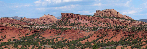
Fisher Towers, 20 miles northeast of Moab, offers one of Utah’s most scenic hikes along the Colorado River. The 2.2-mile trail winds past towering spires to a viewpoint of Professor Valley. Discover its geologic story: https://t.co/8B6ihBuJpO
#utahgeology
0
5
20
New publication: Delineation of Geoheritage Sites in Utah (Davis, Cope, Milligan, DS-3). A new framework highlights Utah’s most valuable geologic landmarks—739 sites evaluated, 129 ranked, and the top 10 featured in detail. Read more– https://t.co/e6vUE7CxDK
0
0
2

Today we’re launching Scholar Agent, your AI copilot for scientific exploration. Scholar Agent breaks the shackles of the Google Scholar search experience. It plans and runs multiple searches, applies filters, and synthesizes results into a clear, citation-backed report⤵️
10
22
62
Geologists created a basic unit called a formation to classify and map rock layers. Formations are given names that include the geographic name of a permanent feature near the location where the rocks are well exposed. Learn more about formations here– https://t.co/0rJBL087bh
0
0
4
Photo of the Week: Near Hite, San Juan County. The Henry Mountains rise above the Triassic Moenkopi Formation and Jurassic Wingate Sandstone—rocks deformed by magma that cooled into a laccolith. Photographer: Adam Hiscock | #utahgeology
2
3
11
Gear up your next off-road adventure with the ultimate trail guides. From Moab backroads to Utah’s northern wilderness, we’ve got you covered with maps, tips & more. Find them at the Natural Resources Map & Bookstore in SLC, or https://t.co/TbG8xd8tr8.
0
1
3
Castle Rock Campground sits in Joe Lott Creek Canyon, surrounded by cliffs carved from the Sevier River Formation. Part of the Marysvale volcanic field, the area saw intense volcanic activity 27–19 mya, leaving deposits over a mile thick. Read more: https://t.co/3ejgts2S8E
1
1
7

Big news!!! FOUR Organics is officially at PopUp Grocer in NYC's West Village! Our mission has always been simple: create the cleanest lip balm possible with just FOUR organic ingredients. No compromises, no unnecessary additives—just pure, effective hydration. We're thrilled
1
2
63
Happy #FossilFriday !

Have you ever wanted to dig up ancient fossils that could end up in a museum? With the St. George Dinosaur Discovery Site, now you can. https://t.co/8Dz6nS0imS
1
1
4
New UGS publication: Fault Trace Mapping and Surface-Fault-Rupture Special Study Zone Delineation of Quaternary-Active Faults in Central Utah (RI-293). High-res lidar data reveal updated fault traces and hazard zones in Sevier Valley and beyond. Read more: https://t.co/z25jFAd4RZ
0
0
2
Photo of the Week: Fishlake National Forest, Sevier County, Utah. Fall colors and snow highlight lichen-covered Miocene volcanic boulders along Johnson Valley Reservoir. Cloud shadows dapple the Fish Lake Hightop, part of Utah’s Tertiary volcanic plateaus. #utahgeology
0
1
8
Agate, chert, and jasper are microcrystalline quartz varieties with a waxy or dull luster, often formed when groundwater fills rock fractures and cavities. Find out where to collect here– https://t.co/nPEfUMZPcf
#utahgeology #redjasper
0
0
7

This is Olive. The AI data dashboard creator. Watch me use it with ChatGPT Atlas to research my demo database and build the most impactful tool possible.
1
3
11
Raplee Ridge in southeastern Utah features colorful, zig-zagging rock layers resembling a “Navajo blanket.” These striking patterns decorate its steep western slope. Learn more: https://t.co/zlop7Q4zU2
#utahgeology #geosight
0
2
12
UGS Senior Geologist Elliot Jagniecki is co-author of a recent publication: "Significance of Spring Inflow to Great Salt Lake, Utah, U.S.A." Read more– https://t.co/FUDGoy1V0Z
#utahgeology
0
0
2
Mount Olympus, Salt Lake County. Photographer: Becka Downard The platey shale of the Proterozoic-age Big Cottonwood Formation resembles a stack of chocolate bars where it is exposed on the north side of Neffs Canyon. #utahgeology
0
4
13
High temps and sulfur gases leave Roosevelt Hot Springs (Beaver Co.) barren of plants, its soil stained vivid yellow and orange. Photo by Mark Milligan Learn more about this location here– https://t.co/DOpSZC51Pl
0
0
6

Would you trade free healthcare for stronger borders?
9
0
10
Tony Grove in Cache Co. highlights Utah’s alpine beauty & geologic past. Glaciers carved its lake, while fossil-rich rocks record ancient oceans. Today, it’s a top spot for hiking & camping. Learn more: https://t.co/PjnHORl28C,
#UtahGeology #GeoSights
0
2
7
New UGS study maps & surveys Utah’s montane wetlands—vital for clean water, wildlife, & recreation—and develops a new index to assess wetland health. Read here: https://t.co/95hsHcTZhc
#utahgeology #utahwetlands
0
0
3
Salt Lake Co.’s Wasatch Front canyons offer beauty, recreation, history & over a billion years of geology. Explore with this geologic tour before you go– https://t.co/DU35ZA4bO5
#utahgeology
0
1
6