Dave Leip
@uselectionatlas
Followers
3K
Following
0
Media
33
Statuses
303
Dave Leip's Atlas of U.S. Presidential Elections
Ithaca, NY
Joined June 2013
New full official results township maps for 2025 New Jersey Gubernatorial Race now available.
0
0
1

“Get Honest Or Die Lying: Why Small Talk Sucks” available everywhere 5/21/24!!! “Small Talk Annoys You. Not Because You Don’t Have The Social Skills, but because it feels insincere and forced.”- S.Mcnutt Let’s Discuss….Pre Order Link In My Bio!!
2K
222
704
With a turnout in the IA Caucus 41% lower than in 2016, this chart shows the results including non-voting Republican registration.
6
1
8
Full data and maps for Wisconsin 2022 - County & Town - for Senate, Governor, Secretary of State, State Treasurer, and Attorney General.
1
1
5
Looking at the NH Senate Maps - especially Swing, several places pop up as potential errors in the data - Columbia in Coos County had a 94% swing and 1000 more votes than in recent elections. In the opposite direction, Canaan has a 38% swing and 500 votes less than previous years
1
0
2
Full City/Town maps for NH 2022 (Senate/Governor). https://t.co/Eb5Xl3MAlI based on the NH SoS Data.
0
0
1
2022 Election Predictions and Endorsements will close down at 3pm on Tuesday. Be sure to get your final prognostications in.
0
0
0
Next up for 2020 Presidential Results by County Subdivision (CS) is Kanas: https://t.co/PSOp7NhcQp Only 26/1531 CS voted for Biden - only 14 of these are home to 34% of the KS population. Throw in Wichita (Trump won by <2%) and its 48%. 1224 (80%) of KS CS have < 1000 residents.
4
4
23
Per Request, here is the 2021 New Jersey Governor by Municipality: Interactive version is here: https://t.co/xX5TVZR6Fi Swing map by municipality is also particularly interesting.
3
5
64
Illinois Population Map by county subdivision to compare with the previous Presidential Map. New feature in the interactive mapping tool for 2020 now provides both statewide and county-level population maps by CS for many states. https://t.co/GGk9v8r5Ow
0
2
7
Completed Illinois Map by County Subdivision after updating new Menard County Precincts. Interactive version here: https://t.co/wBkOViYBz3
5
7
51
It looks to me that the official results by county would in of itself violate the privacy rule given the whole county has less than 10 voters in one congressional district.
0
0
6
Do the congressional redistricting boundaries in Nevada violate voter privacy law? The law requires protecting secrecy of a voters ballot & the vote by precinct is suppressed when turnout is less than 10. Both Churchill & Lincoln counties are split with <10 voters in one CD
2
0
4
Note the large number of California Recall voters that did not select a replacement candidate. The Yes/No vote is currently at 9,137,428 while replacement candidates only received 5,057,345 (a drop-off of 44%). County maps here:
0
1
3
To use the interactive township map at https://t.co/FE9n07Fxeo or one of the other states, click the "H" next to the desired gold colored map button to the left. Then the image map highlights the boundary of the municipality under the mouse and pops-up results. See attachment.
3
0
5
Completed Pennsylvania 2020 Presidential Election Map by municipality. Interactive version can be seen here: https://t.co/mhCyePUGkG
7
14
93
Completed Michigan 2020 Presidential Election Map by town. Interactive version can be seen here: https://t.co/nvePtXs1wl
2
9
46
Completed New York 2020 Presidential Election Map by town. These data are most recent available (many counties have updated their official results after the 12/3 board certification). Interactive version can be seen here: https://t.co/GW2pH7Y08t
3
8
55
New 2020 New Jersey map for President by municipality has been added. Interactive version here: https://t.co/zBNMKXJ2BN
2
4
33
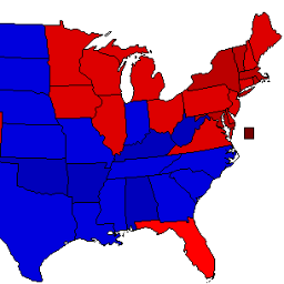
Closing in on the final national popular vote totals from state and county agencies - Biden 81,284,716 (51.3%), Trump 74,223,367 (46.8%), Jorgensen 1,865,911 (1.2%). Projected EC Biden 306-232.
1
2
5