
Roger Hill
@rehill57
Followers
3,740
Following
252
Media
838
Statuses
1,582
Professional storm chaser, Guinness World Record holder for most tornadoes documented, tour operator, photographer, author, slot canyon fanatic, bowler.
Denver, Colorado
Joined December 2009
Don't wanna be here?
Send us removal request.
Explore trending content on Musk Viewer
Trump
• 3652411 Tweets
Justice
• 773834 Tweets
Jury
• 722882 Tweets
New York
• 417037 Tweets
The American
• 410349 Tweets
Democrats
• 344005 Tweets
Supreme Court
• 225393 Tweets
Rigged
• 210974 Tweets
Republicans
• 161918 Tweets
POTUS
• 112572 Tweets
White House
• 98849 Tweets
Rule of Law
• 91987 Tweets
Dems
• 80843 Tweets
Clinton
• 77392 Tweets
Hillary
• 75598 Tweets
Fox News
• 58633 Tweets
Stormy Daniels
• 56947 Tweets
Alvin Bragg
• 54717 Tweets
NO ONE IS ABOVE THE LAW
• 34658 Tweets
Law and Order
• 32141 Tweets
#StateOfPlay
• 25565 Tweets
Michael Cohen
• 22058 Tweets
#SVGala13
• 21991 Tweets
DeSantis
• 21906 Tweets
Norita
• 20621 Tweets
Overwatch
• 17728 Tweets
Kiko
• 17230 Tweets
#LockHimUp
• 16035 Tweets
エリート刑事
• 15879 Tweets
RIP America
• 14322 Tweets
Silent Hill 2
• 12712 Tweets
温帯低気圧
• 10846 Tweets


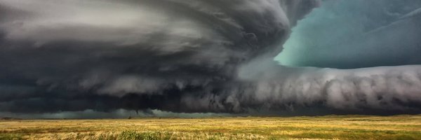
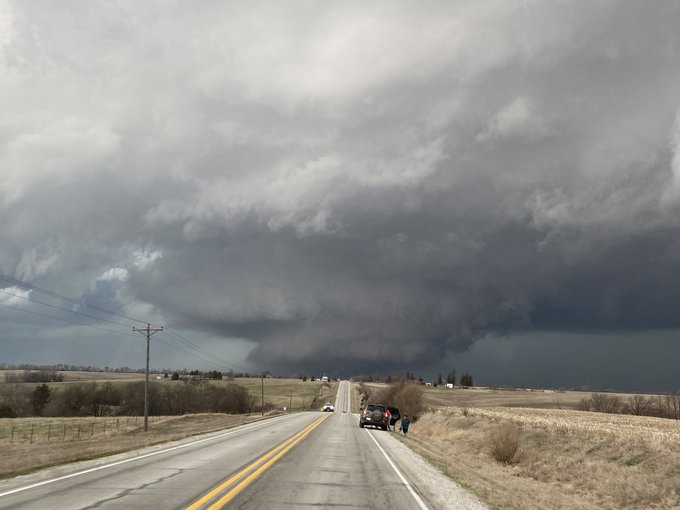
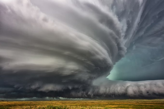
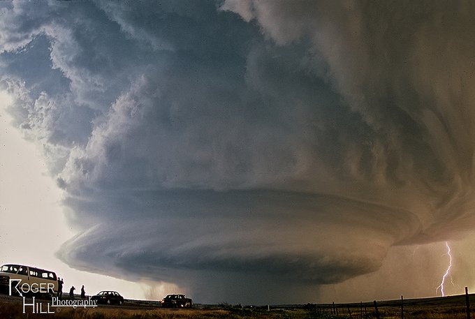
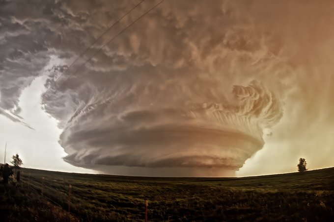
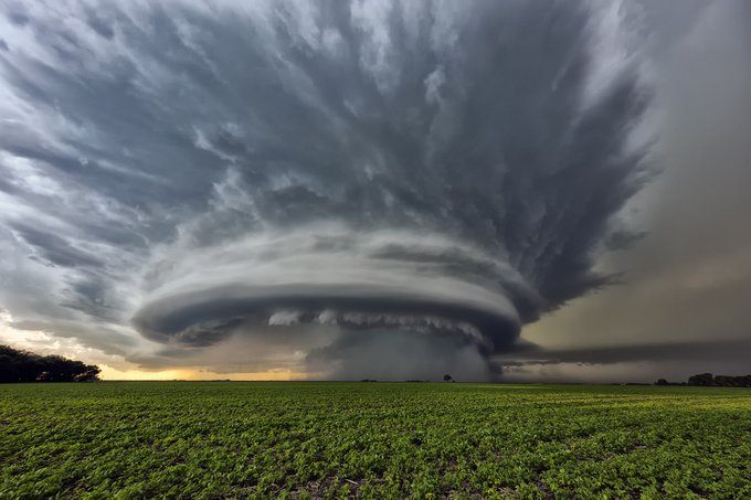
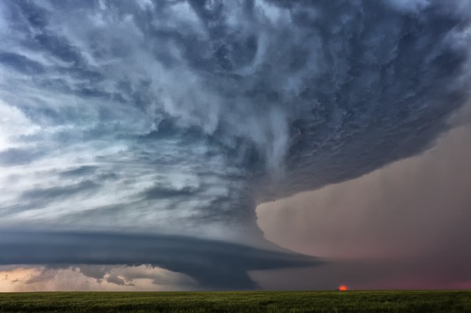
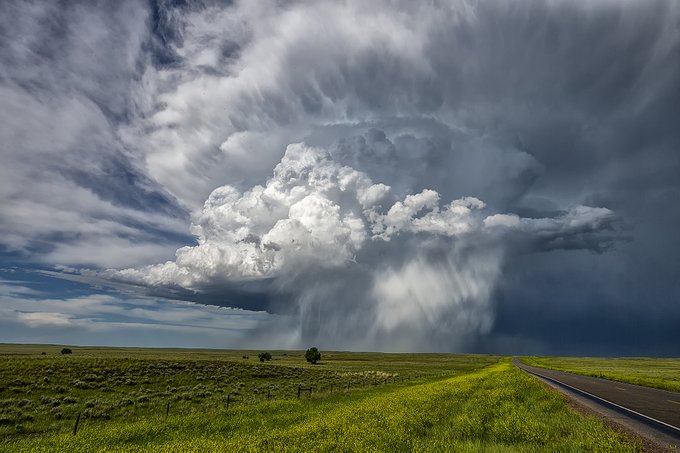
An amazing display of structure yesterday. This shot (taken while driving unfortunately!) of the INCREDIBLE updraft of the Dover, OK tornadic supercell! The structure was far better than the tornado!

35
208
2K
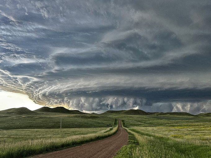
Telluride, CO now. Storm clouds parted and left this AMAZING scene!!! Colors are perfect now!
23
170
1K
WOW. What can you say. Last night's Sweetwater supercell was a jaw dropper!!!!
14
181
952

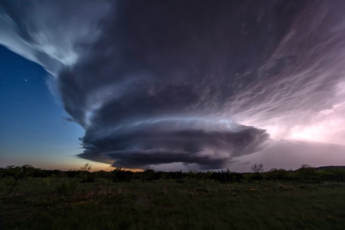
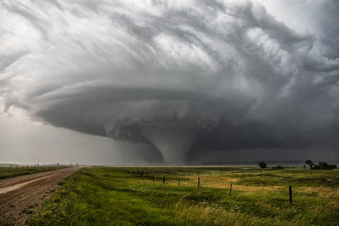
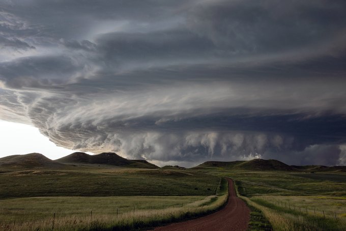
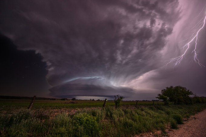
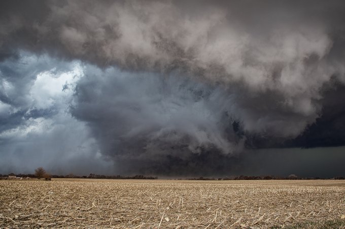
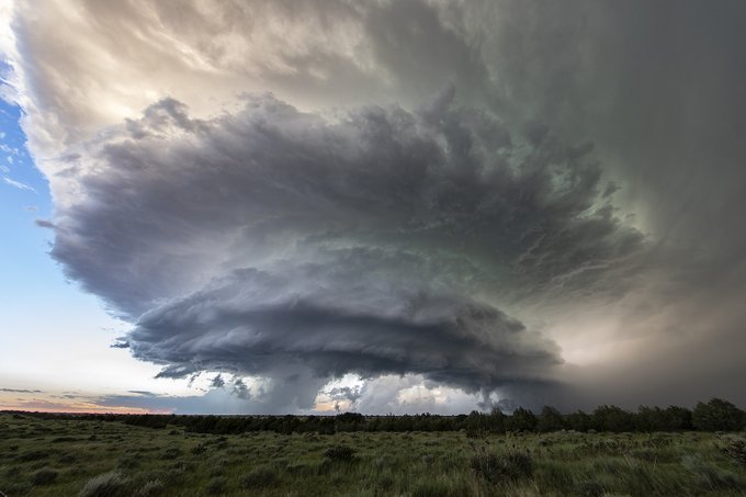
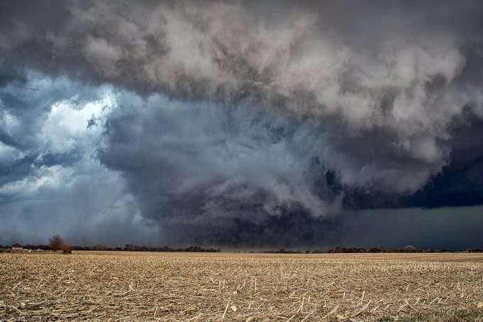
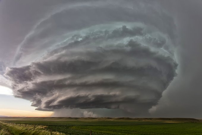
Montana at it's finest! This tornadic supercell occurred near Capitol, MT 6/28/2018 and produced 8 tornadoes. In my 38 years of chasing, this one ranked in the Top 10!
11
118
798
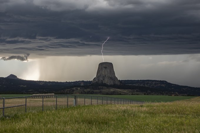
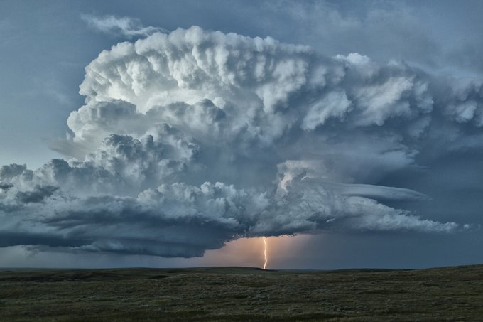
Lightning striking the top of Devil's Tower, Wyoming on July 19, 2020 from a developing supercell. One of those bucket list shots!
20
102
792
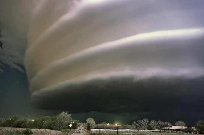
Cutting Room Floor. The Spaceship is Landing!!!!!! April 22, 2013 near Weatherford, OK, as a night supercell bears down on the town with tennisball hail. Great day earlier near Leedey and it kept on spinning in the dark!
25
111
725
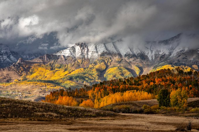
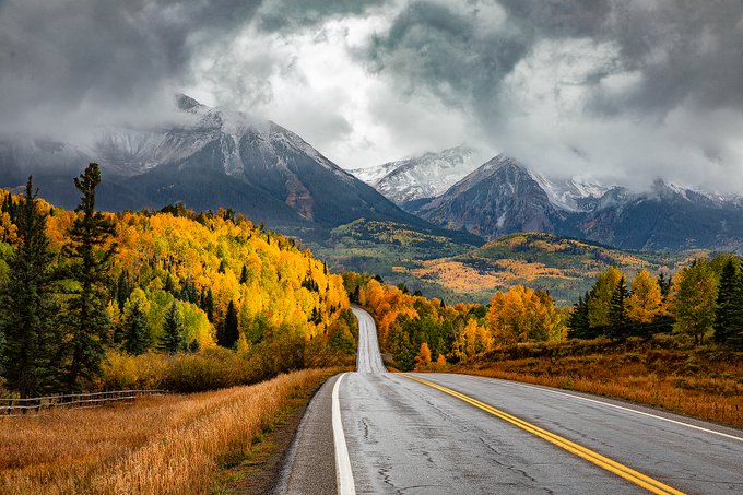
Mt Wilson, CO in its fall glory as storm clouds broke last week.
13
83
699
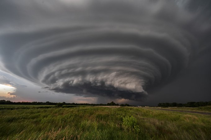
Kansas at its finest! One of the prettiest supercells I've seen there in over 35 years of chasing! Douglass, KS 6/26/2018.
18
79
671
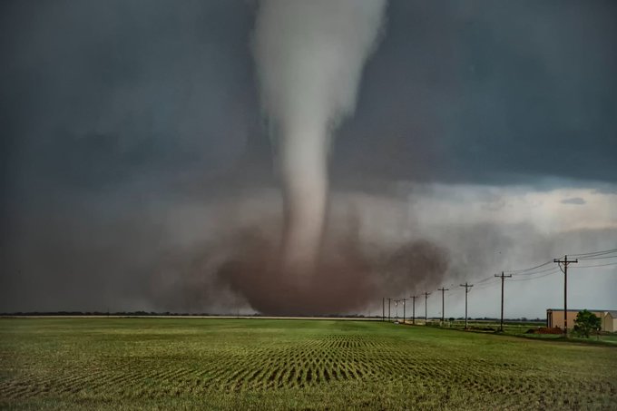
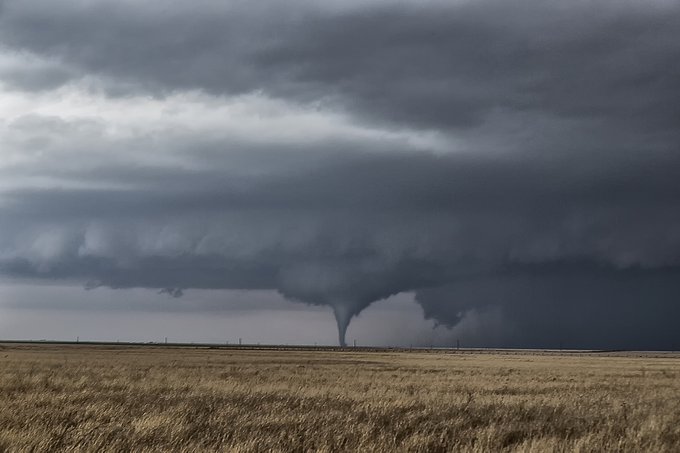
Coolest November nighttime tornado event in the Texas panhandle! 11/16/2015 near Groom, Texas.

8
70
661
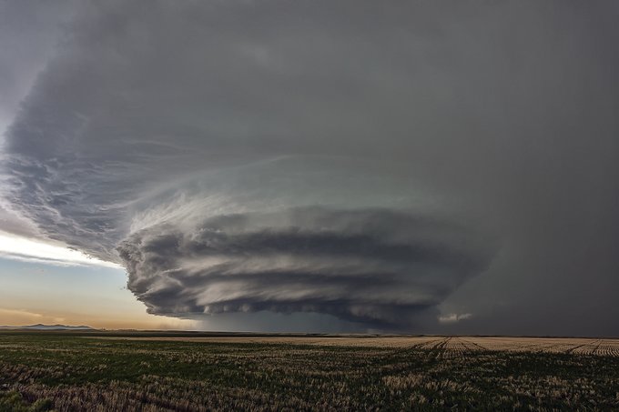
Spectacular HP supercell near Judith Basin, MT, complete with tornado on June 5, 2012. One of those great Montana set ups!

13
72
606
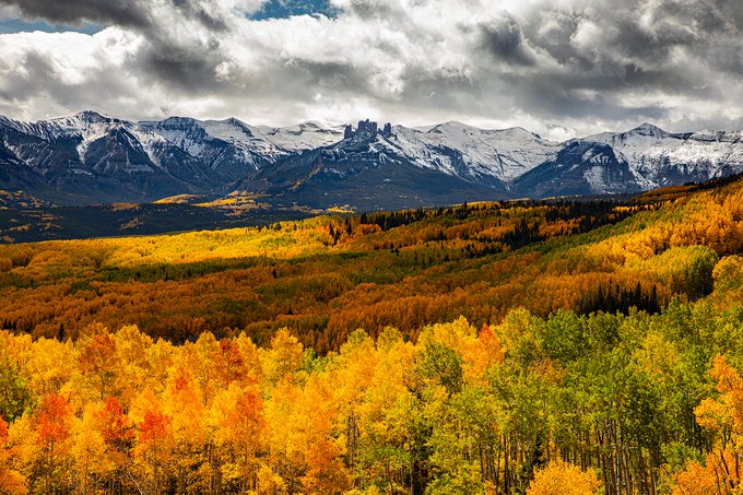
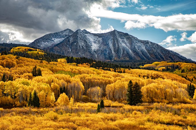
Mt Beckwith and Kebler Pass are stunning in the fall. The largest single grove of aspen trees in Colorado is located there. It is also considered the largest living organism in the world!
6
79
588
Oh to have had a tripod and digital camera on this shot from May 29, 2001 near Turkey, TX. One of the prettiest HP supercells I've ever seen! The late Tim Samaras was a tour guide for us and standing next to me whooping and hollering! (Nikon F5 film camera)
13
67
578

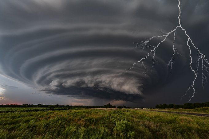
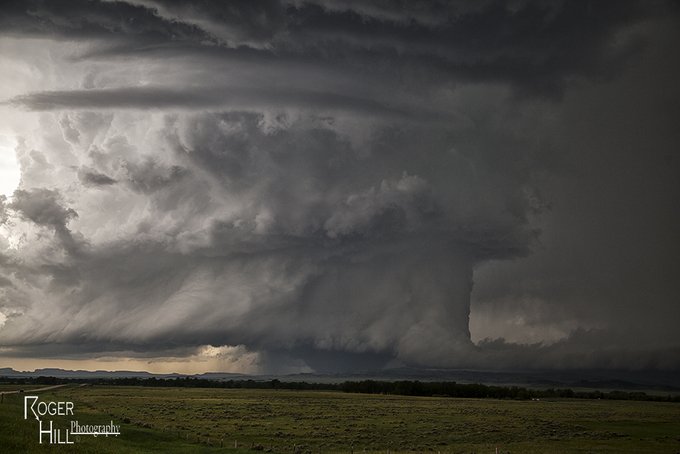
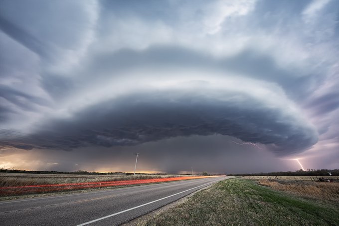
Broken Bow, Nebraska 5/26/2013. That barber pole was such a beauty! You can see the laminar appearance down low due to limited 100MB CAPE, and clearly see the LFC in the mid levels of the updraft. An electrified machine!

4
87
561
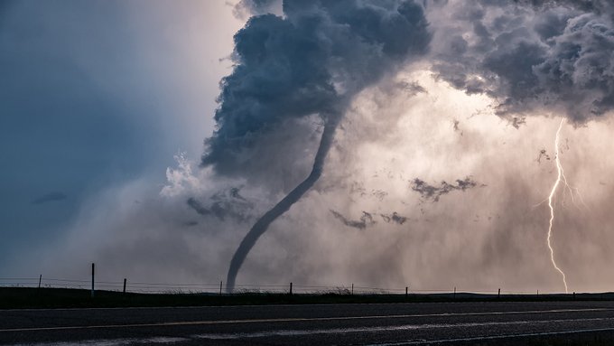
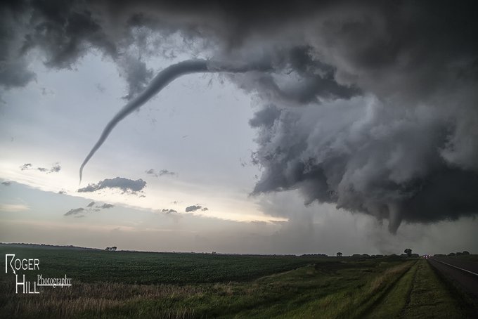
The rope out of the June 18, 2014 Alpena, SD EF4 tornado was just amazing!
4
52
553
Behold the structure!!!! June 26, 2018 near Douglass, KS! BEAST!
16
73
532
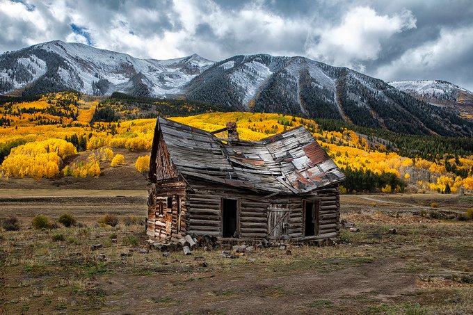
One more fall colors pic! Taken by Crested Butte, this old log cabin is really photogenic with the colors behind it and departing storm.
4
62
532
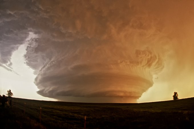
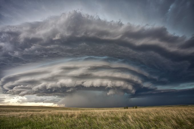
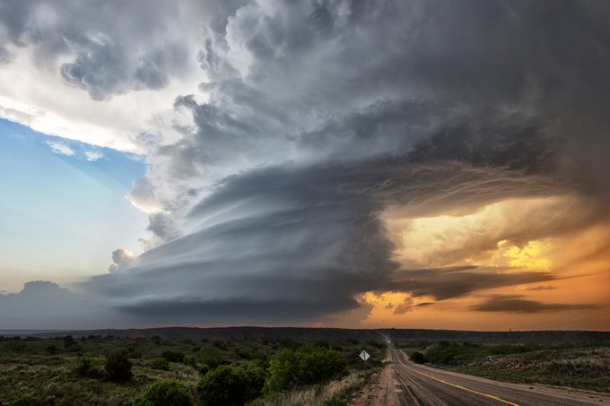
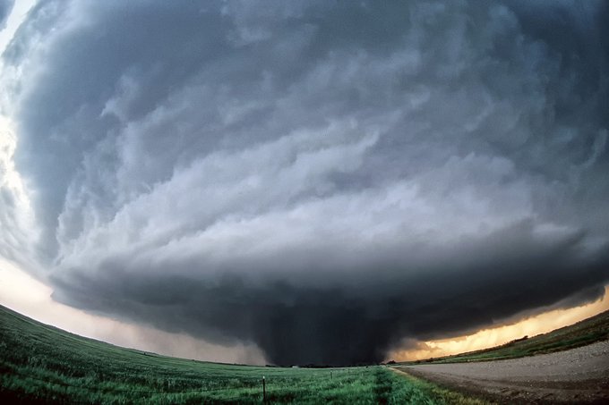
Nebraska's finest! To this date, my all-time favorite HP supercell near Valentine on 7/13/2009. Structure was a 10 PLUS! Low level winds were weak, thus only briefly tornadic, but man that structure was a sight to behold. Storm formed near Sturgis, SD at noon, and at 11pm was
10
64
471
Perfection! The rope out of the Alpena, South Dakota EF4 on 6/18/2014 was just incredible! A couple more South Dakota pics, then on to Nebraska!
10
51
463
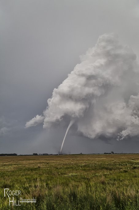
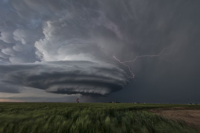
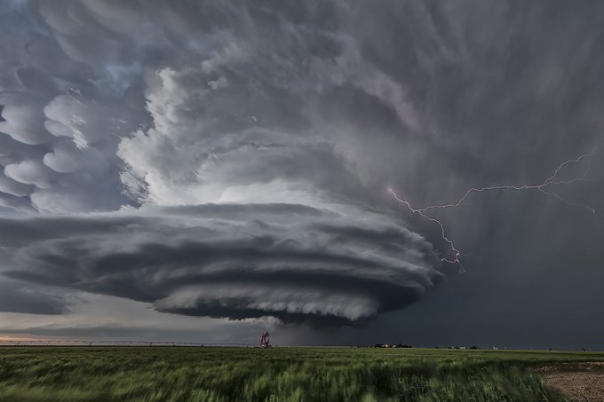
Gorgeous mammatus on a tornadic supercell near Pleasantville, IA 4/4/23.
10
39
452
Wedgefest, Kiester, Minnesota 6/17/2010. This 1.2 mile wide EF4 tornado was on the ground for over half an hour!
9
50
454
One more Montana beauty! This HP supercell near Ft Benton, MT on June 4, 2012 was tornado warned and produced baseball sized hail. Sure was a pretty one!
12
78
446
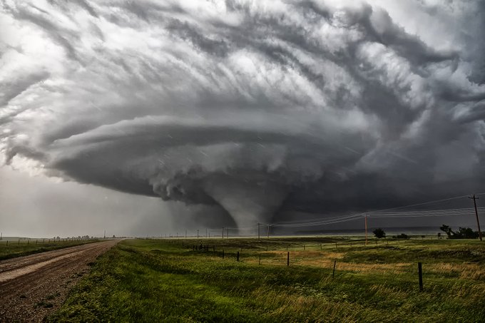
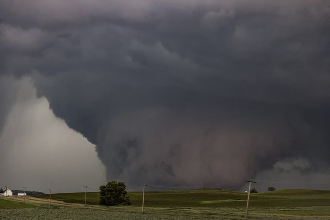
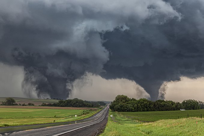
Continuing with Montana, this AMAZING supercell occurred the day after the Pilger, NE twin EF4s. When you get 75 dews in SE MT, a boundary and strong shear, this can happen! This mile wide EF3 was the strongest tornado to ever hit the state. North of Capitol, MT 6/17/2014.
10
72
442
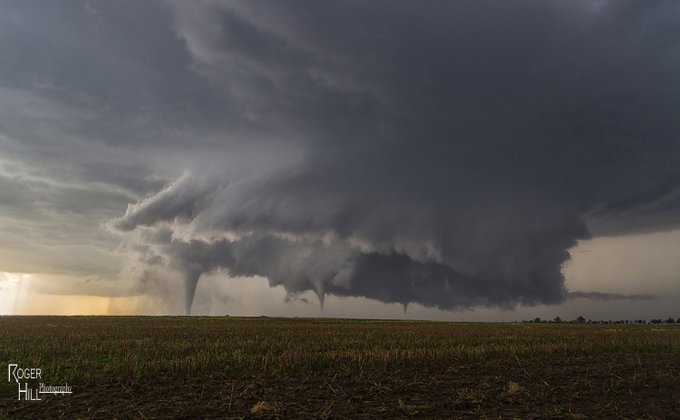
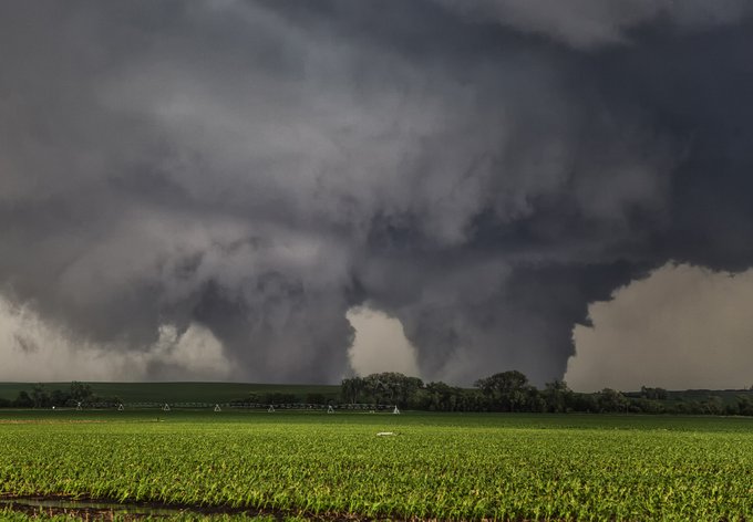
May 24, 2016 was a CRAZY day! We watched over a dozen tornadoes from the Dodge City supercell. This video is a long one, but man, there's some sweet shots here! Enjoy!
8
52
443
A little nostalgia. May 29, 2001 near Turkey, TX. OLD film camera, but man was the structure of this HP insane!
10
42
436
Since I've been on the subject with LP supercells, here's another beauty! Northfield, TX May 23, 2016. Jaw dropper right before sunset, then turned into a tornado machine.
13
66
429
Dodge City, Kansas May 24, 2016, was an incredible day with over a dozen tornadoes, with multiples occurring as well! Incredible event! Here's a link to my Youtube video from that day as well:

9
61
433
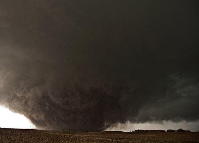
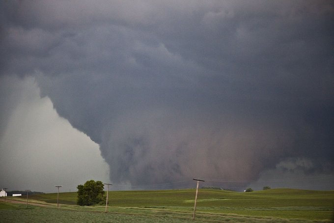
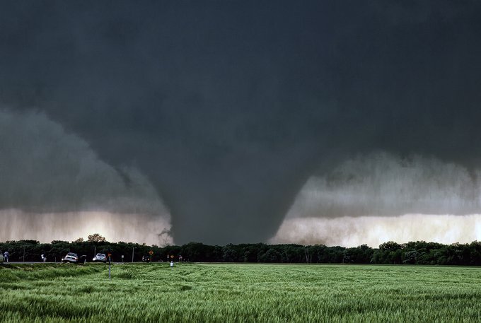
Pilger, Nebraska June 16, 2014. An absolutely amazing event with twin EF4 tornadoes (and 2 other EF4 tornadoes we witnessed). You always hate to see destruction and loss of life. A very tough day for the small town.
11
56
402
Another pretty LP supercell at sunset. It was in its weakening stage here, after it dropped 5 tornadoes on June 21, 2015 in central South Dakota. Sure was an awesome supercell!
5
55
384
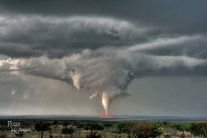
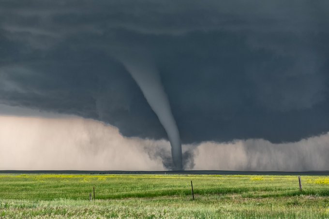
16 years ago yesterday, one of the best March events I've ever seen occurred in the Texas panhandle. Numerous tornadoes, some strong, raked the region. This F3 beauty was in Hall county and was on the ground for many miles! Love the sun lit tornado and red dirt cloud!

5
39
361

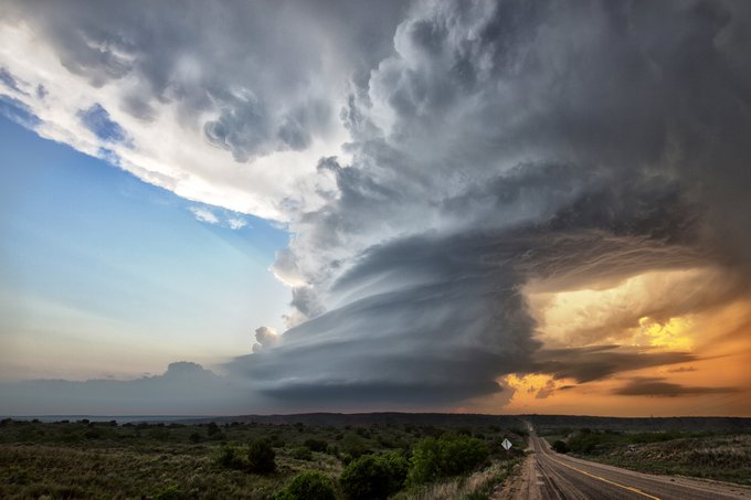
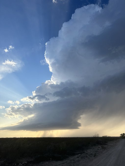
A late summer supercell near Burlington, CO 8/14/2019. As the sun was setting and the cgs continued it was an awesome sight!
5
46
358
Capitol, MT, June 28, 2018. The roar of the beast was amazing!

9
41
350
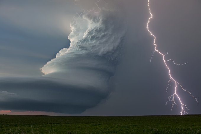
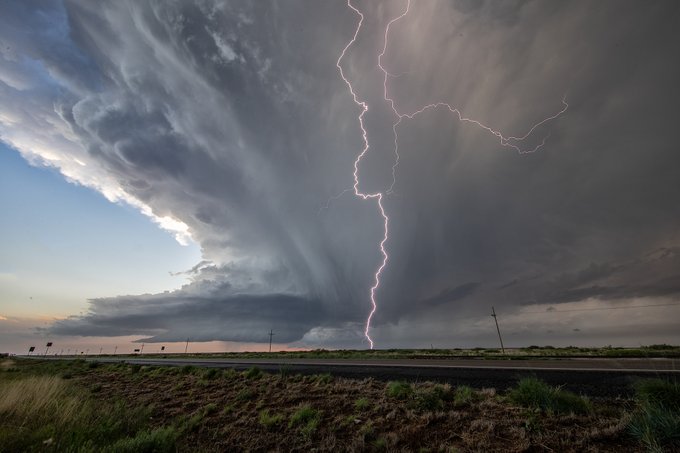
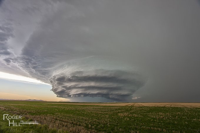
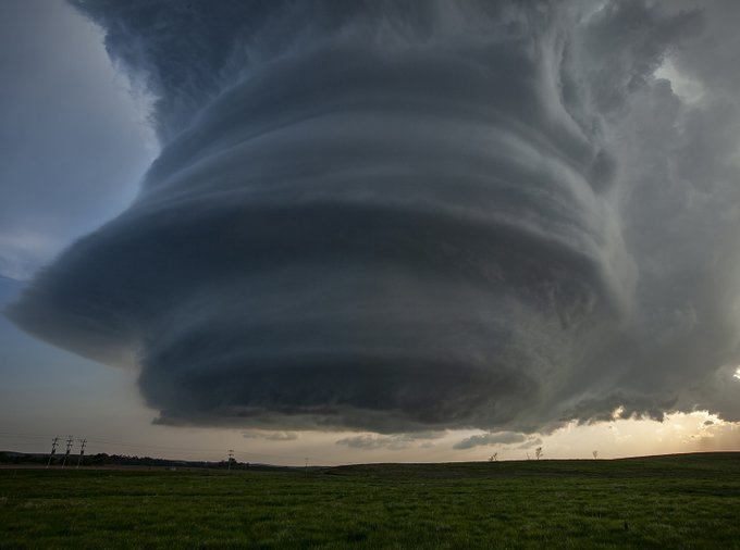
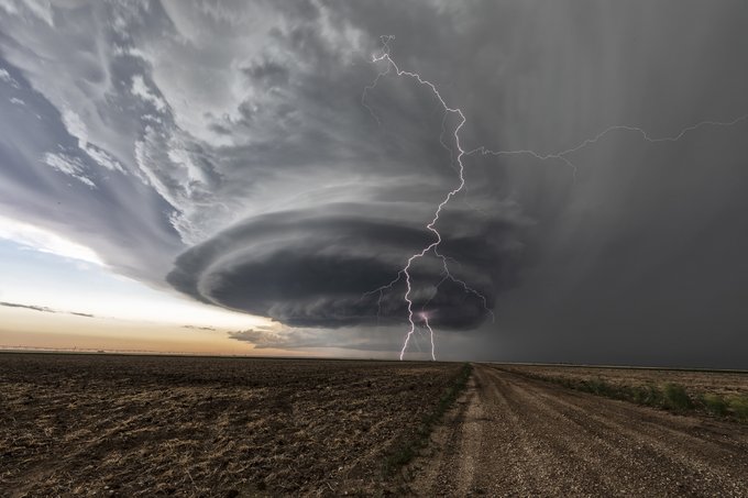
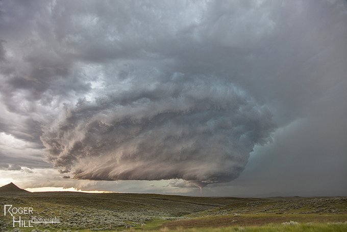
Incredible stack of plates!! WOW!!! Judith Basin, MT June 5, 2012. Insane supercell structure and a CG to boot!
3
55
355
2007 was an incredible tornado year. It certainly started off right with this beautiful F3 tornado on March 28th in Hall county, Texas. Just a jaw dropper!!!
5
42
350
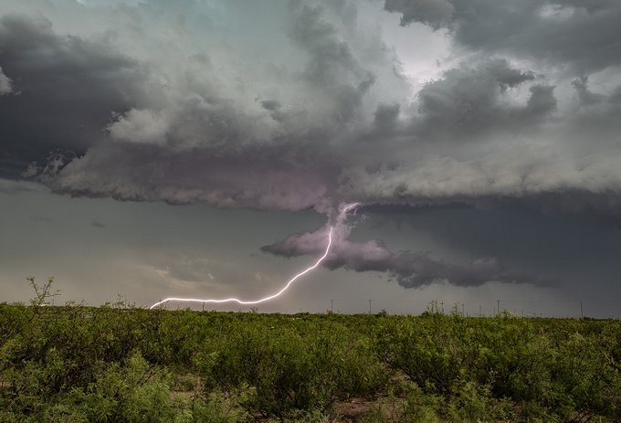
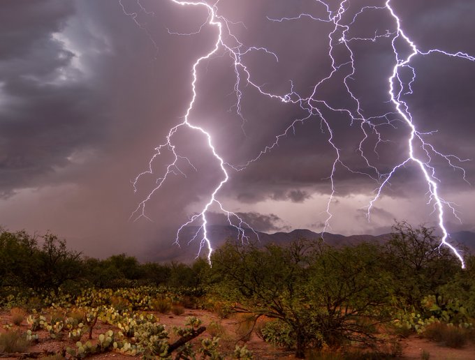
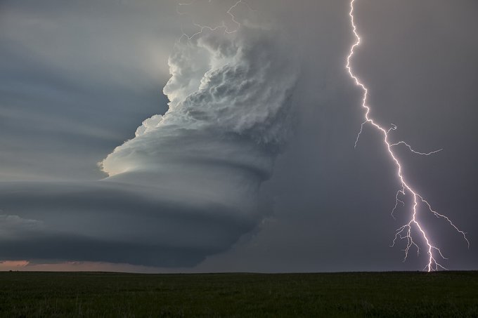
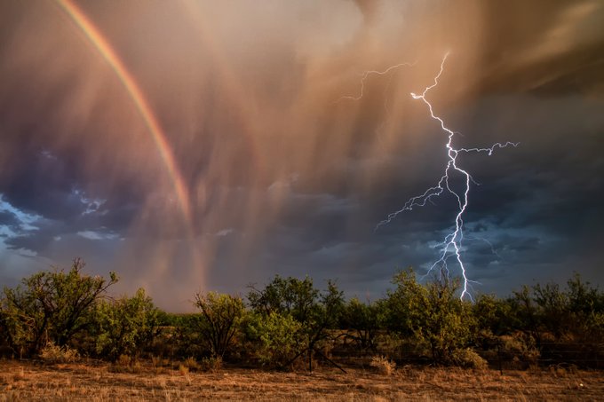
Extremely close double strike near Kitt Peak, AZ during our monsoon trip a couple years ago. Can't wait to get back there later this week!
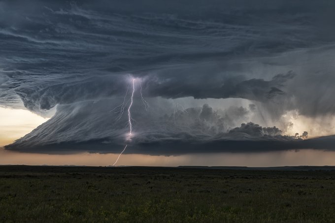
7
59
349
Two more Colorado images, then off to Kansas! Here's another shot of the Burlington, CO 8/14/2019 supercell. What a beauty!
10
53
351
August 14, 2019 stunning supercell near Burlington, CO. What a spectacular and colorful storm!
7
40
347
What a jaw dropper! One of the prettiest HP supercells I've ever witnessed. This 22 year old transparency film image from 5/29/2001 near Turkey, Texas. Very memorable day. Structure was nuts!!

6
41
344
North Dakota BEAST!! On July 11, 2017 this tornadic supercell developed near Hatton, ND. It produced a knarly EF2 multivortex tornado that tracked for 21 miles towards Hillsboro, ND.
5
44
334
Fun shot from a severe thunderstorm north of Medicine Lodge, KS April 14.
4
44
335
Wide shot of an approaching monster supercell over Judith Basin, MT 6/5/2012. A sight to behold!
1
28
332
Another awesome tornado from Capitol, MT June 28, 2018 (photo from my wife Caryn Hill)!!!!!
6
31
327
Cutting Room Floor
#57
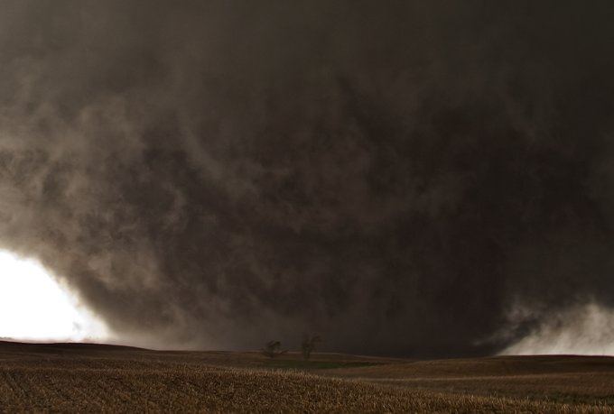
. May 22, 2010, Bowdle, SD. Violent F4 wedge. You can see a farmstead on the right side. The owner and his family raced away at the last minute in his truck and parked by us, asking if we thought it would hit his farm. Unfortunately, it leveled it.
11
46
320
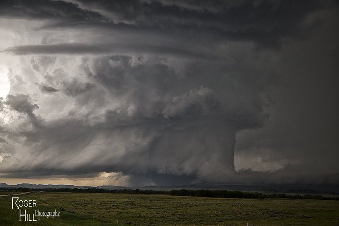
Nebraska!! My next state. This tornado warned LP supercell near Broken Bow on 5/26/2013 was a jaw dropper!!! Great structure but that laminar base shows very little 100mb CAPE.
9
33
320
Ok a couple more Nebraska images before I head over to Iowa. Here's a shot of the Pilger twin EF4 tornadoes from 6/16/2014. Such an incredible day weather wise, but a very sad day for the small town.
2
38
316
The June 10th, 2010 Last Chance, CO tornadic supercell. Dropped 2 elephant trunk tornadoes, but the structure was outstanding!
7
51
314
Conger, MN June 17, 2010. 1.6 mile wide wedge. One of 18 tornadoes we saw this day!
6
34
307
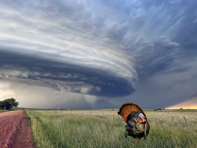
Happy Thanksgiving everyone! Here's my last North Dakota image, a classic supercell turkey tower 😀 June 19, 2023 near the ND/MT border.
6
36
310
What an incredible supercell! One I'll never forget! May 26, 2013 Broken Bow, NE. This LP was the toast of the town!
3
38
309
Cutting Room Floor.
#29
. Highly striated beast near Alliance, NE on June 12, 2017. This supercell had dropped over a half dozen tornadoes from Carpenter, WY to south of Alliance, and spun its way into South Dakota late evening. It was also an electrified beauty!
11
42
303
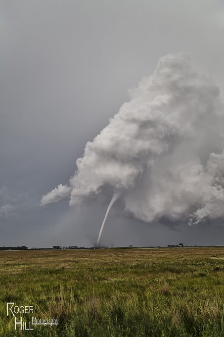
North Dakota tornado. Yes it does happen. This beautiful "Wizard of Oz" looking tornado northeast of Bismark was on the ground for over 20 minutes. Taken 7/16/2011.
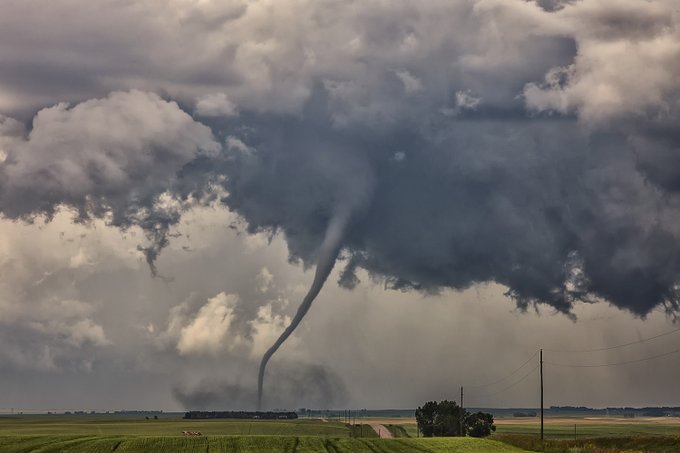
5
34
303
Ok let's keep these LPs going! How about 6/10/2010, Last Chance, CO! This beauty dropped a couple photogenic tornadoes before this pic was taken.

7
41
298
Another shot of last night's colorful supercell north of Kim, CO right before producing a nice tornado. (Pic next!)
7
39
296
More South Dakota! Here's a VERY old, degraded transparency film image from a violent F4 tornado in Brown County, SD June 23, 2002. An amazing day with a half dozen tornadoes from a nearly stationary supercell!
6
40
296
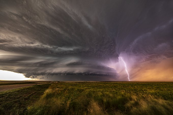
Satanta, Kansas, May 21, 2020. Beautiful, very electrified LP supercell! A bit more moisture and things would have gotten really interesting!
6
34
297
Alpena, SD June 18, 2014. The developing cone tornado grew to an EF4. We witnessed nearly a dozen tornadoes this day!
3
26
287
Montana beauty! 6/21/2010 near Broadus, MT. This pretty supercell dropped 3 tornadoes.
4
29
289
May 28, 2013. Bennington, Kansas. What a monster wedge! Dang thing sat nearly stationary for over half hour.
9
24
285
Pretty west Texas LP supercell from June 17, 2019. Even had a tornado warning on it for a bit, however it was a big time hailer!

2
45
283
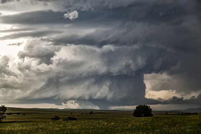
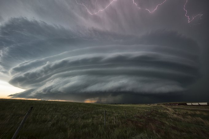
Grass Range, South Dakota tornado warned supercell from July, 2012. Gorgeous structure and an amazing amount of clear channel bolts this thing produced!
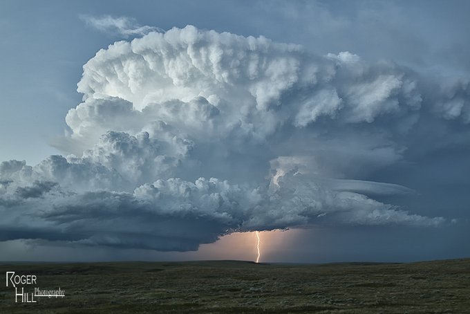
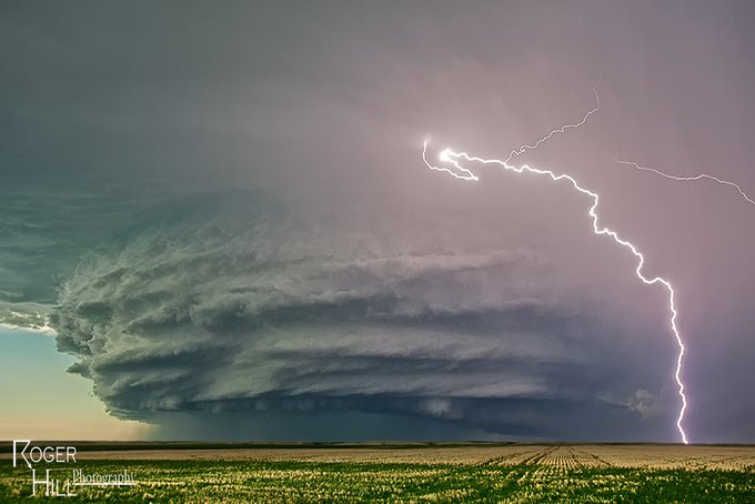
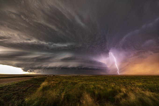
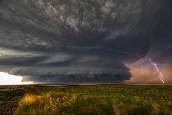
8
38
278
Something warm and humid to vision on this cold Christmas eve day. Judith Basin, MT (06/05/2012)
9
30
279
4
25
274
Another Satanta, Kansas shot from May 21, 2020. What a beauty!!
5
27
282
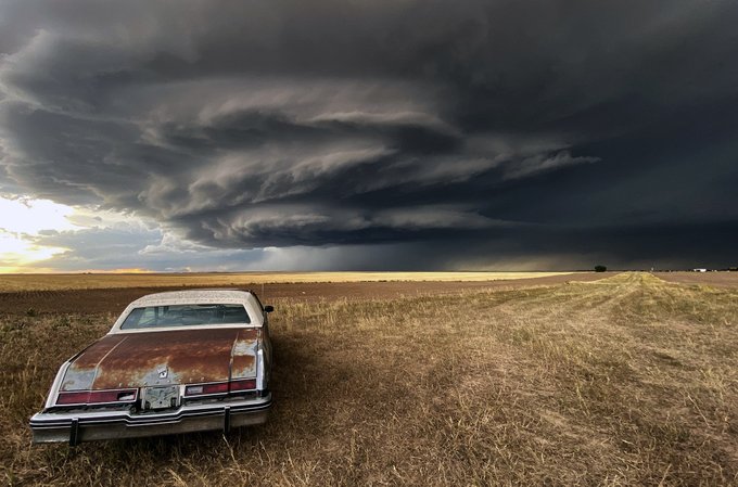
More Wyoming fun! Cool old car and stack of plates supercell near Carpenter on July 19, 2020. Quite the prolific hailer!
3
28
279
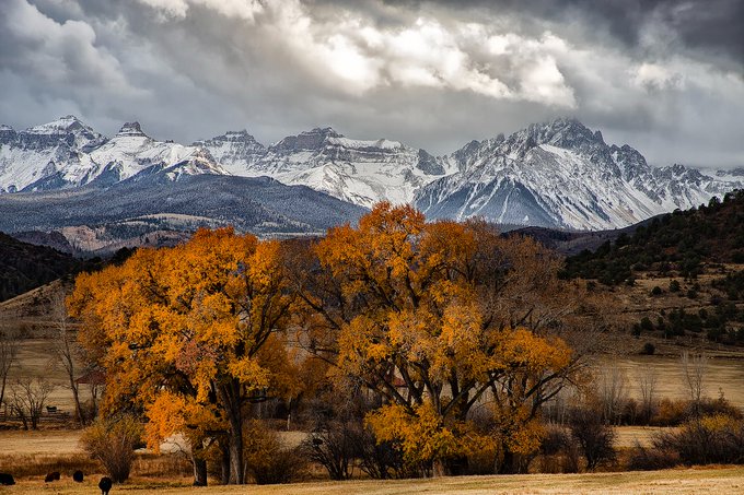
Snow blankets the San Juan mountains of southwest Colorado, as cottonwood trees turn yellow and orange. The aspen leaves are gone now, but cottonwoods are at peak. Near Ralph Lauren's ranch, Ridgeway, CO. Taken 10/28.
8
32
271
South Dakota at its finest! This sunset tornadic supercell near Glad Valley, SD on 6/21/2015 was just stunning. It had produced 5 tornadoes earlier in its life cycle in northwest SD. Just a reminder any image I post here can be purchased! Just pm me for details!
6
31
268
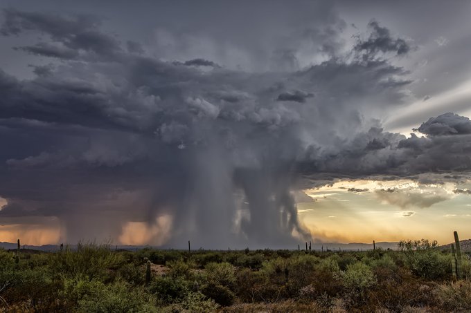
Awesome monsoon core from 7/31/23 east of Ajo, AZ! Beautiful!
2
27
266
My last South Dakota shot before moving on to Nebraska. The full blown EF4 Alpena, SD cone from 6/18/2014. What a beast!

6
31
267
Cutting Room Floor.
#35
. Sometimes it is nice to stay back and see the wide view of a supercell. This June 25, 2019, high based storm was near Newcastle, WY and was a prolific hailer. Love seeing the structure with updraft/downdraft visible and being lit by the sun.
3
39
263
The Bowdle, SD wedge from May 22, 2010. Very close, very loud. EF4 that barely missed town, thank goodness! Fortunately, no fatalities.
2
33
257
Awesome arrival day storm west of Tucson for our 17th annual Desert Thunder Tour! Incredible sunset!
5
46
261