

Paula Paz
@paulapaz13
Followers
535
Following
2K
Media
45
Statuses
459
Topographic Engineer, Master student, Universidad del Valle, Cali, COL. Research associate, CIAT. Terra-i : Monitoring land cover change and SERVIR Amazonia
Cali, Colombia
Joined January 2010
The COP16 on biodiversity is happening during the next week in my city! 🌿🌎 Join us if you're in Cali, Colombia, and want to learn more about tools using AI and remote sensing for biodiversity monitoring. #COP16 #Biodiversity #AI #RemoteSensing
0
3
9
La jornada de hoy finalizó con la visita a #SemillasdelFuturo, donde en una feria científica compartimos proyectos innovadores en temas cruciales como #InteligenciaArtificial, edición #genética, iniciativas de #cacao y paz, #biofortificación, y otros, impulsados por la Alianza.
1
2
10
@USAID through #SERVIRAmazonia Program and hub partners @NASA and @BiovIntCIAT_eng finished today the 12-day training delivered by the Program in the use of #geospatial technologies in Trinidad and Tobago 👏🏼 @SERVIRGlobal @sig_gis 1/2
1
8
16
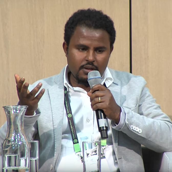
#WomenInScienceDay Topographic engineer Paula Paz leads the expansion of #SERVIRAmazonia in 5 #Caribbean countries. Her motivation has been to find solutions to environmental problems such as climate change and deforestation. 1/2
1
10
30
#Barbados #TrinidadandTobago #Guyana #DominicanRepublic have already received the first workshops in Mangrove and Hydrological Events #GIS Capacity Building #SERVIRAmazonia improves resilience in local communities. Read the full article here ➡️ https://t.co/1NxE8f7yGh
#Caribbean
0
4
6
A second workshop “Introduction to Remote Sensing” held in #Barbados ended yesterday with 21 participants. This session introduced participants to the use of moderate and high-resolution satellite imagery for geospatial analysis 🛰
2
8
26
.@SandraDurangoM, Investigadora de la Alianza @BiovIntCIAT_esp, presenta el Acuerdo Cero Deforestación en #Colombia: el caso de la Cadena Láctea.
1
8
19
#News Capacity-building training has been delivered in #Guyana and #Barbados to improve mangrove monitoring and management of hydrological events 🛰 Demand-driven training was co-designed to best meet the needs of local stakeholders #SERVIRAmazonia @BiovIntCIAT_eng @SERVIRGlobal
1
18
27
Global deforestation accelerated due to the COVID-19 pandemic? new article lead by @BiovIntCIAT_eng using @terrai_ciat data. Open access:

link.springer.com
Journal of Forestry Research - As the COVID-19 pandemic unfolded, questions arose as to whether the pandemic would amplify or pacify tropical deforestation. Early reports warned of increased...
0
4
11
#Happeningnow discussion between Ethiopia Forestry Development, @CIFOR, @BiovIntCIAT_eng, Ethiopia Space and Geospatial institute on the development of near-real time forest monitoring tool for Ethiopia.
0
3
9

A look back at last week's #MonitoringAcclerator with @CATIEOficial! Participants from 8 national governments in #LatinAmerica met in Costa Rica for a week of knowledge exchange. Many discussions on improving monitoring systems and tracking the effects of restoration policy 🗺️
1
7
25

On Sunday, Brazilians go to the polls to elect their next president. But at stake is something far more important than the leadership of the largest economy in South America.
2K
15K
40K
La herramienta de monitoreo de coberturas @terrai_ciat fue presentada por @PerezAndrehs en el taller de 'Los Acuerdos #CeroDeforestación #Colombia', como una opción para hacer seguimiento a la red de proveeduría de las empresas del sector lácteo y cárnico. #SLUS
0
3
7
User Needs Workshop in the Dominican Republic 🇩🇴 #Caribbean together @intecrd with stakeholders in🛰️ #geospatial technologies to learn about the capabilities and current services GT in the country #ServirAmazonia
0
1
14
También se presentación de resultados específicos del proyecto SAB: 📋Monitoreo, reporte y verificación de la deforestación. 🌴Establecimiento participativo de áreas de conservación en sistemas de cacao y palma aceitera 📉Monitoreo, reporte y verificación de las emisiones #GEI.
1
3
7
We started the #ServirAmazonia User Needs Assessment Workshop with geospatial actors from Trinidad and Tobago together with Caribbean Meteorelogical Organization.
0
2
16
The main themes of interest of #SERVIRAmazonia by countries were identified in our first meeting with the Caribbean Stakeholders #AmeriGEOWeek2022
More re: #Caribbean countries' specific priorities from @SERVIRAmazonia ⬇️. #EarthObservation #LACI #AmeriGEOweek2022
https://t.co/3b3lJN4lXW
0
2
6
#SERVIRAmazonia in the Caribbean User Engagement results in a session presented in #AmeriGEOWeek2022
#ICYMI @JLRFernandes of CIAT / @SERVIRAmazonia presented on @SERVIRGlobal's pilot activities in the #Caribbean during the #LACI session @ #AmeriGEOweek2022. RE: priorities, among others, they highlighted a need for capacity building in #EarthEngine.🤔 https://t.co/kKeYw1DbEp
0
2
13
Flood detection💧🌎 method applied in Honduras using RS will be presented next Monday.
📌 Acompáñanos en el evento de socialización y presentación de avances de la plataforma #AguadeHonduras. 📆 22 de agosto 🕣 8:30 a.m. 🇭🇳 📍 Centro Interactivo, SERNA – MIAMBIENTE 🔴 Sigue la transmisión: https://t.co/aQxPpz3MLF 💧 Más sobre la plataforma: https://t.co/eZUyuYCYDl
0
1
2
📌 Acompáñanos en el evento de socialización y presentación de avances de la plataforma #AguadeHonduras. 📆 22 de agosto 🕣 8:30 a.m. 🇭🇳 📍 Centro Interactivo, SERNA – MIAMBIENTE 🔴 Sigue la transmisión: https://t.co/aQxPpz3MLF 💧 Más sobre la plataforma: https://t.co/eZUyuYCYDl
0
9
10