
Oklahoma Mesonet
@okmesonet
Followers
24,510
Following
753
Media
5,600
Statuses
13,272
Official Twitter account of the Oklahoma Mesonet. A joint project of @UofOklahoma & @okstate providing 5-minute weather data from 120 stations across Oklahoma.
Oklahoma
Joined October 2009
Don't wanna be here?
Send us removal request.
Explore trending content on Musk Viewer
Will Still
• 123409 Tweets
Rio Grande do Sul
• 109632 Tweets
#MOONLIGHT_MVTeaser
• 94331 Tweets
プロフェッショナル
• 54135 Tweets
RPWP CONCEPT PHOTO 2
• 47000 Tweets
JOONGDUNK LOVE WORKPOINT
• 34776 Tweets
YOASOBI
• 28234 Tweets
青山先生
• 27947 Tweets
SDカード
• 24528 Tweets
عدنان البرش
• 15686 Tweets
#無責任でええじゃないかLOVE
• 14127 Tweets
VACHSS
• 13809 Tweets
排外主義的
• 13664 Tweets


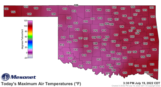
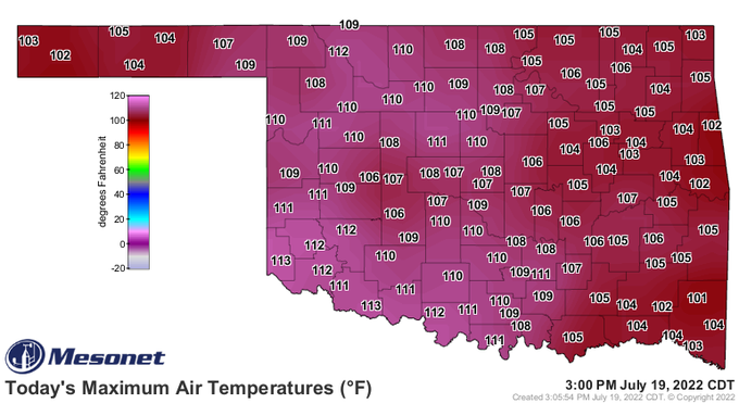
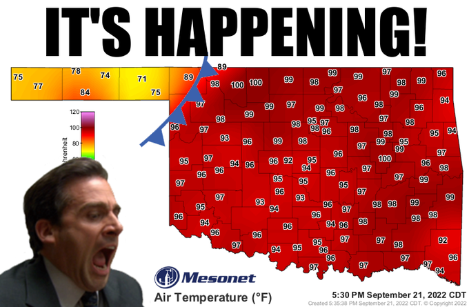
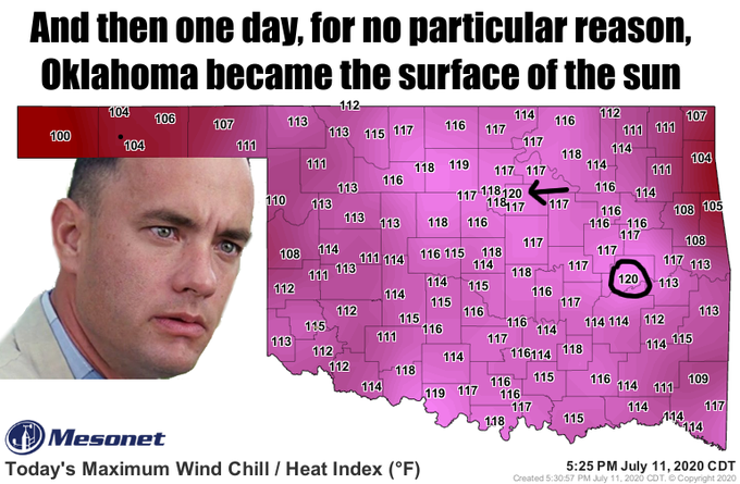
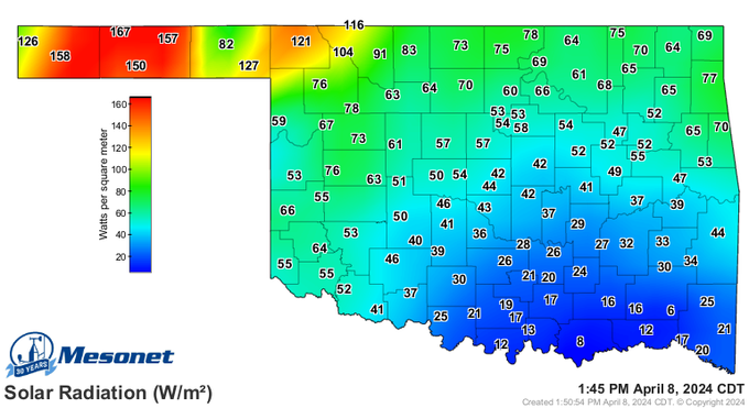
Introducing the newest Oklahoma Mesonet extreme: 126F heat index at the Paul’s Valley site. This is our highest ever heat index measurement in our nearly 30 year history. 😳
#okmesonet
#okwx
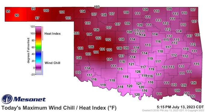
25
263
660
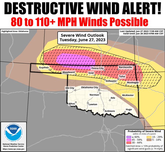
A derecho (a widespread, long-lived wind storm that is associated with a band of rapidly moving showers or thunderstorms) has been forecast by SPC, with widespread damaging winds of 80-110 mph with the line of storms later this evening. MAKE PREPARATIONS NOW!
#okwx
#okmesonet
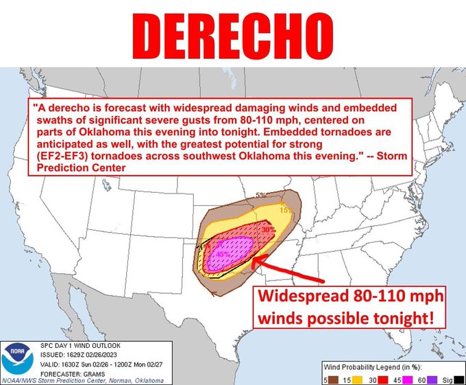
15
248
557
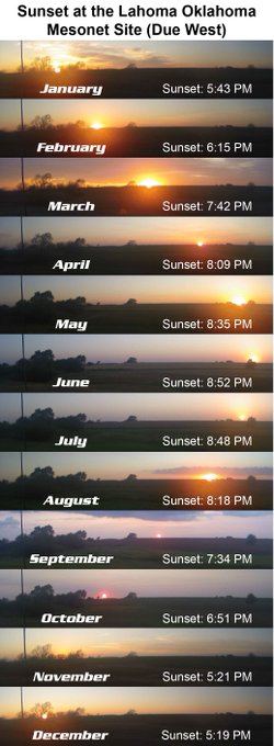
Oklahoma sunsets really are a thing of beauty - made even more beautiful when seeing 12 side-by-side! These shots were taken around the middle of each month during 2020 from a camera at our Lahoma
#okmesonet
site. 😍
#okwx

4
116
530
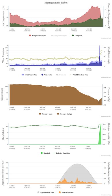
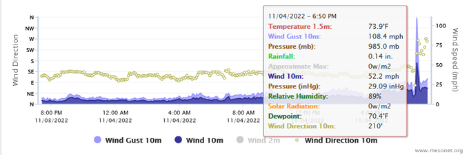
At approximately 6:50 pm, the Oklahoma Mesonet site at Idabel was struck by what is believed to be a tornado. The site recorded a maximum wind gust of 108 mph with the expected precipitous pressure drop.
#okwx
#okmesonet

6
173
496
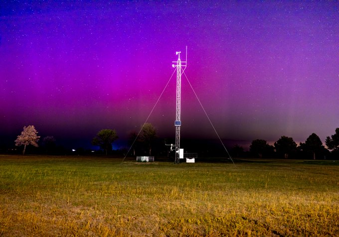
The view of the Northern Lights from the Medford Mesonet location, taken by Oklahoma Mesonet technician Steve Thompson. Incredible sight at an incredible site!
#okwx
#okmesonet
9
71
460

UPDATE: All
#okmesonet
sites have hit 102F or higher today. This is the first time in our network's history (dating back to the mid 1990s) to have 120 sites hit that mark on the same day. Before today we had 2 days with 100F or higher (7/9/11 and 7/10/11).
#okwx
14
208
447
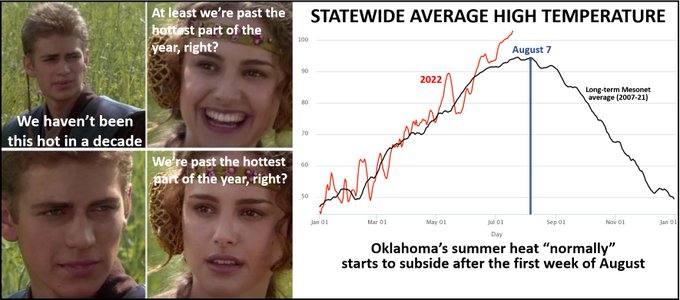
We're calling it. One more hot day, then a smooth transition into early fall! Oh, it will still get hot here and there, but you get rid of that final August heat, you're on the downward slide. Come on, have we ever been wrong before? Okay, other than those times?
#okwx
#okmesonet

22
70
426
For only the 3rd time in
#okmesonet
history, all 120 of our sites hit 💯F. But wait there's more...
For the FIRST TIME in Oklahoma Mesonet history all 120 sites hit 101F or higher. And the day's not over yet...
#okwx
10
156
361
Today marks the 15 year anniversary of one of the more unusual
#okwx
events - the re-strengthening of Tropical Storm Erin over Oklahoma! Check it out ⬇️
#okmesonet
9
57
329
That's not a typo, straight-line winds could gust over 110 mph with some of the storms. Mostly northern OK after 6pm, but everybody needs to stay alert for changing conditions as the storms could spread southward through the center part of the state as well.
#okwx
#okmesonet
22
111
327
Nature is beautiful. This was captured by our technician Steve at the 2023 National Weather Festival.
#okwx
#okmesonet
#NWF23
2
55
328
Mesonet Ticker: DANGER DANGER
Hurricane force winds could be widespread with the line of storms, and there is a threat of significant tornadoes as well, especially across SW OK. STAY ALERT!
#okwx
#okmesonet
10
102
312
Mesonet Ticker: The Suck Zone (WITH CORRECTED OUTLOOK MAP)
Did we REALLY need to turn the "Twister" sequel into a REALITY SHOW?!? Strong tornadoes and giant hail are possible with the storms today, 3pm-9pm or so.. START PREPARING NOW!
#okwx
#okmesonet
12
74
312
Confirmed by our QA Meteorologists, at 126.19F, the Miami Mesonet site just broke our previous all-time heat index record of 126.0F set at Pauls Valley previously this year on July 13. If it continues to go up today, it will reset the record.
#okwx
#okmesonet

15
108
313
What do you get when you combine a temperature of 97F and a dewpoint of 84F? YOUR FACE MELTED OFF! Just ask Okmulgee, which hit a heat index of 125 today.
#okwx
#okmesonet

13
62
309
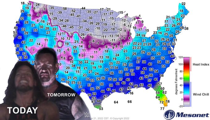
In typical Oklahoma fashion we've gone from 60s and 70s to freezing rain and sleet in just a few hours. This data animation helps to summarize what's happened over the last day or so (ends at 7pm on Feb 20, 2018)!
#okwx
#okmesonet
4
171
284
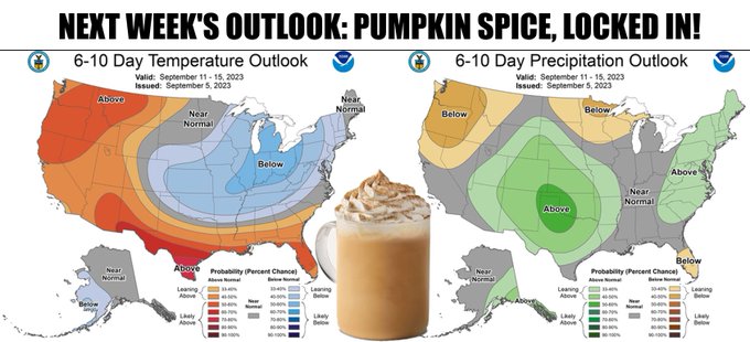
THE FRONT IS HERE! Quick, go get a pumpkin spice latte and throw your sweater on.
#okwx
#okmesonet
8
21
287
Not the best visualization but here's a rough look at the Oklahoma Mesonet's detection of the pressure waves that passed through from the Tonga eruption this morning.
#okwx
#okmesonet
17
82
277
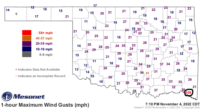
Idabel's 108 mph wind speed measurement tonight ranks as the 5th highest wind speed the
#okmesonet
has measured since 1994 and the strongest in more than a decade. We have now measured 100mph or higher 10 times.
#okwx
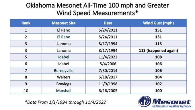
7
105
264
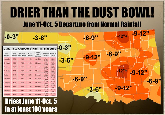
Record-setting dry weather over the last 30 days...of all the June 11-July 10 periods in the last 100 years, none have been drier than 2022's version. The previous record holder is from 1936, smack dab in the middle of the Dust Bowl. Click for embiggenation.
#okwx
#okmesonet
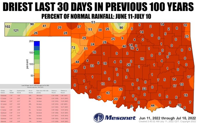
11
101
258
Tired, frustrated, or outright mad about the big swings in the winter storm forecast this week for the Southern Plains? Just imagine being a meteorologist or those tasked with ensuring public safety during storm events. This about sums up their week ⬇️
#okwx
#okmesonet
16
58
237
Here's a look back at a very busy week of weather for Oklahoma (May 20-27, 2019). Flooding, tornadoes, and lots of NWS warnings.
#okwx
#okmesonet
6
95
228
STOP THE PRESSES! Are there still presses? The Mesonet's all-time heat index record fell for the second time today with a reading of 126.74F. That tops Miami's previous record-beater from earlier today of 126.19F.
#okwx
#okmesonet
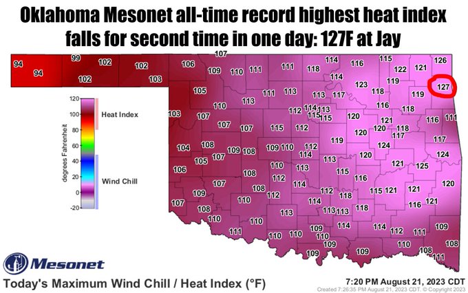
10
86
235
Mesonet Ticker: Cross everything ya got!
We really REALLY need this forecast to hit, so everybody wash your cars, buy tickets to the State Fair, and make wedding plans for next week!
#okwx
#okmesonet

12
45
232
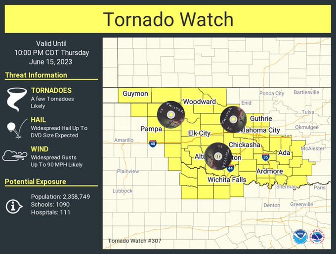
Particularly Dangerous Situation (PDS) tornado watch through 10pm! Who's had enough?
#okwx
#okmesonet
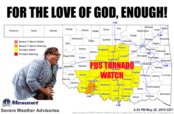
12
70
222
We are heartbroken to learn about the accident involving 3
@ousom
students. We wish to express our condolences to their families. Students, faculty, alumni, and
@NWCNorman
colleagues we walk with you in grief and stand ready to provide support.
#OUDNA
#RIPOU3
6
21
230
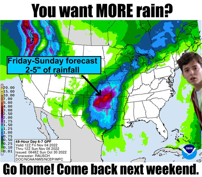
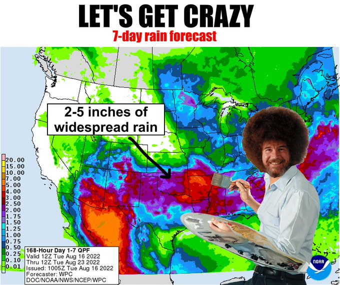
Seven-day forecast amounts keep going up! Where are we gonna put it all? Start building those arks, folks.
#okwx
#okmesonet

6
23
227
Check out the beautiful cycle of sunsets observed from an experimental camera at the Lahoma Mesonet site. 😍😍
#okwx
#okmesonet

3
54
224
UPDATE 2: All
#okmesonet
sites hit 103F or higher today. This is the first time in our network's history (dating back to the mid 1990s) to have 120 sites hit that mark on the same day. Before today we had 2 days with all sites hitting 100F or higher (7/9/11 and 7/10/11).
#okwx

8
103
223
Well that escalated quickly! Let's hope it DE-ESCALATES just as quickly. Strong tornadoes and giant hail are both possible tomorrow! Start preparing for tomorrow's hazardous weather NOW and you'll feel better.
#okwx
#okmesonet
6
51
217
Bigtime storm system has its sights set on Oklahoma next weekend! Drought relief but also some bigtime severe weather possible. It IS Oklahoma after all. Every season is severe weather season here.
#okwx
#okmesonet
5
32
219
Oklahoma Mesonet extremes...2023 edition! What's your vote for our craziest measurement this year?!
#okwx
#okmesonet
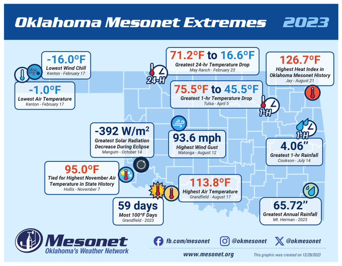
8
63
216
Check out this shot of a supercell that passed over the
@NWCNorman
a bit earlier this evening.
#okwx
#okmesonet
2
34
217
What does it look like when 3+ inches of rain falls in 1 hour? ⬇️ Video taken from an experimental camera at the Tulsa Mesonet site.
#okwx
#okmesonet
4
71
211

We are sensing a great disturbance in the atmosphere. This weekend looks brutal. Like Darth Vader brutal!
#okwx
#okmesonet
10
176
199
UPDATE on our llama vs. field technician spitting incident from earlier today (did we really just write that?!)....we've learned it was a face hit. All are well but our technician Mark no longer likes llamas. ❌🦙
#okwx
#okmesonet
13
34
201
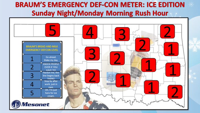
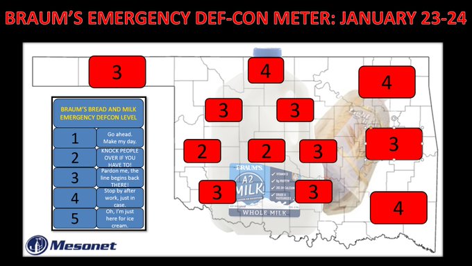
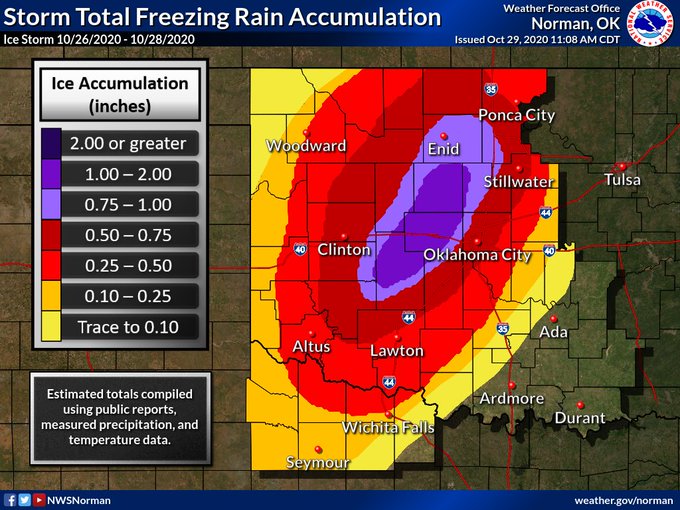
Alright stop, listen close and heed, Ice is back with a dangerous storm indeed. Frigid grip, Oklahoma's in a chill, the forecast says it's gonna be a winter thrill. WE DON'T MESS WITH ICE! Word to your local Braum's.
#okwx
#okmesonet
5
37
202
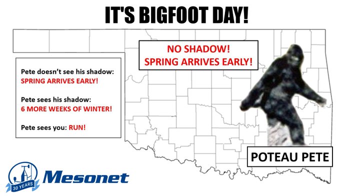
It's Bigfoot Day in Oklahoma! No, we don't need some rodent in Pennsylvania predicting our weather. Our favorite Sasquatch Poteau Pete says spring arrives early this year! GO tell him he's wrong...I dare ya.
#okwx
#okmesonet
9
51
202
Mother Nature to Oklahoma: "I'm your Huckleberry." Odds are increasing for a significant winter storm across Oklahoma later this week, wed-fri. Dangerous cold is CERTAIN, snow and ice accumulations are PROBABLE, significant accumulations are POSSIBLE.
#okwx
#okmesonet
8
54
193
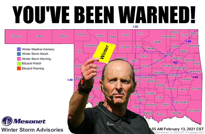
Wow. How often do you see the entire state of Oklahoma in a Winter Storm Warning? Incredible.
#okwx
#okmesonet
8
41
192
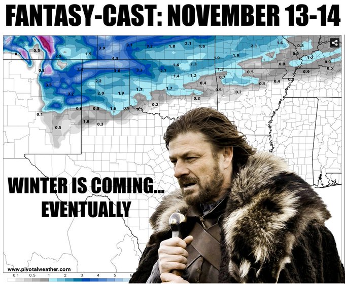
NOW LISTEN, no, it probably won't happen, but when it starts showing up in the fantasy-cast territory (after day 10) in the models, it means Mother Nature is in the mood for winter. Braum's, you listening?
#okwx
#okmesonet
7
20
190
120 heat index at Eufaula and Stillwater? That's just stupid hot! Of 120 sites, 58 hit a heat index of at least 115 degrees.
Stupid is as stupid does, SUMMER!
#okwx
#okmesonet
10
67
182
Mesonet Ticker: No cap fr fr
To get rain Friday, we need storms. To get storms, we need to beat the cap. To beat the cap, we need heat. To get heat, we need the sun. To get sun, we need...well, you get the picture.
#okwx
#okmesonet

8
25
188
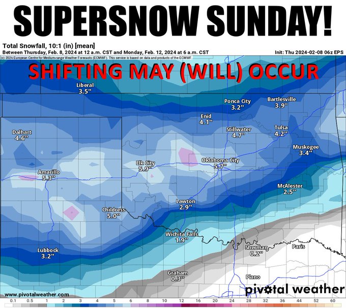
Just as an example of the shift to the south and east a bit, and also a bit more impactful on the totals. Super Bowl Sunday is gonna be dramatic as heck!! Oh yeah, there's a game played that day, too.
#okwx
#okmesonet
8
21
186
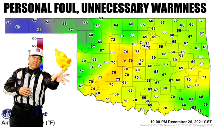
Come on, this is getting ridiculous. You go outside at El Reno and Kingfisher at 10pm on Dec. 26 and it's 76 degrees? Their RECORD HIGHS for today are 69 (El Reno) and 72 (Kingfisher), for crying out loud! Yeah, throw the flag on Mother Nature
#okwx
#okmesonet
6
33
182
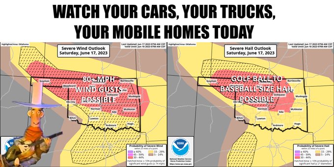
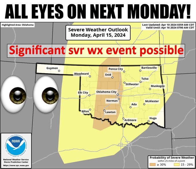
OOF! SPC has upgraded parts of Oklahoma to a Moderate threat (and we all know just how painful that can be). And the tornado risk has increased westward to near I-35. That hail threat though! Start preparing now, have a plan!
#okwx
#okmesonet
0
62
185
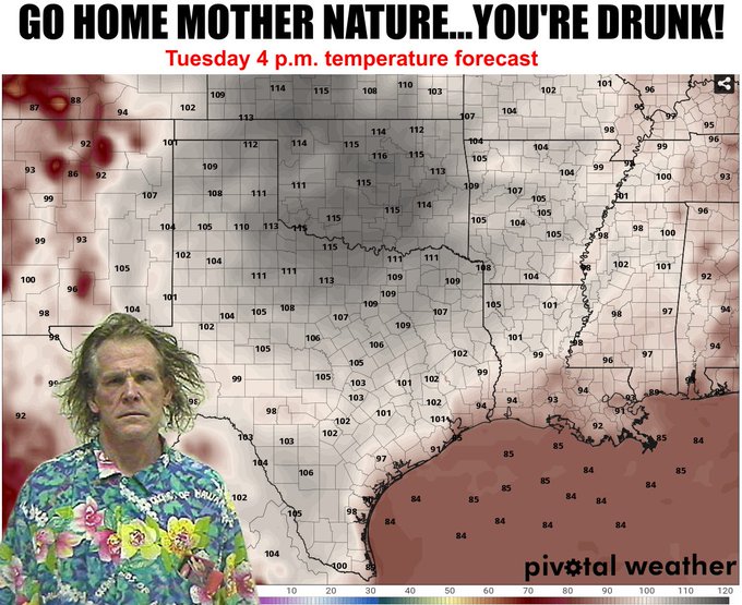
This is just ONE forecast model, but if this happens Tuesday it will be the hottest weather we've seen since those 2011-2012 mega-hot time summers. We hit 113 in 2020 (Hollis) and 2018 (Grandfield), but 115 was back in 2012 (Kingfisher) and 2011 (Hollis).
#okwx
#okmesonet
10
39
182
How it started. How it’s going.
Some areas with a temperature swing of more than 90 degrees over the last 7 days. 😲 That’s Oklahoma weather for ya!
#okwx
#okmesonet
3
43
177
Have a little lightning with your sleet this morning! Roads will be slick where the heaviest ice falls under these convective bands so be careful.
#okwx
#okmesonet
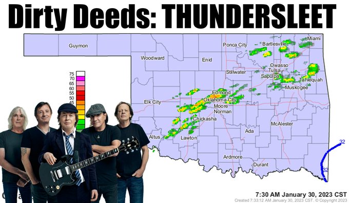
5
29
182
That 107 down in Altus, Ladies and Gentlemen, is THE highest temperature ever recorded on a May 9 in Oklahoma, going back to the 1880s. It tops Hollis' 106 from 2011. Yay?
#okwx
#okmesonet
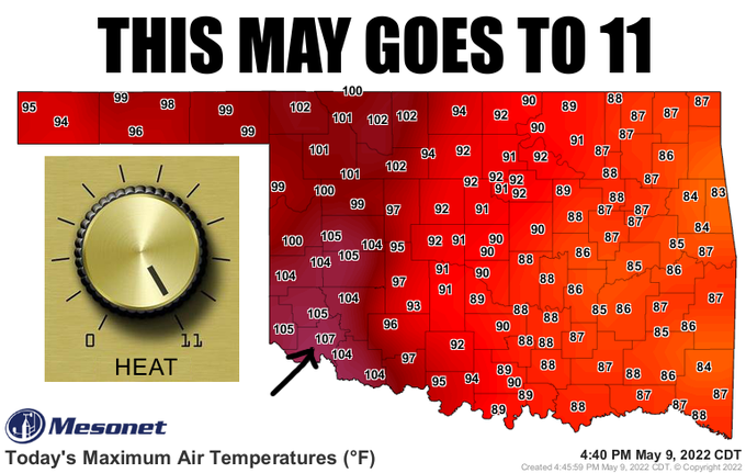
22
52
176
It’s days like May 20, 2019 that the
#okmesonet
was made for. As we do everyday, we will be working tirelessly to ensure data are high quality & available for viewing throughout. If you see any interruptions, please be patient as we likely will have very high user load.
#okwx
2
20
175
Today the Oklahoma Mesonet officially turned 30 years old! Happy New Year everyone!
#okwx
#okmesonet
6
6
175
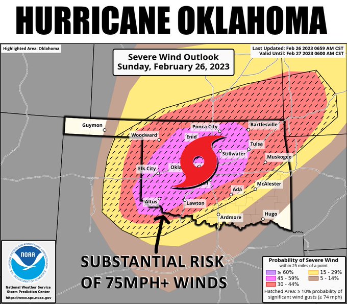
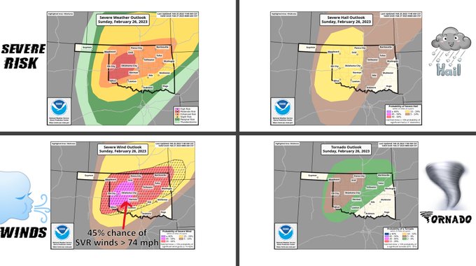
Sunday's severe weather appears to be transitioning to a bigtime severe wind event across much of the state with a large area at risk for winds > 74 mph! Tornadoes are possible as well, especially early in the event.
#okwx
#okmesonet
5
39
175

6
40
170
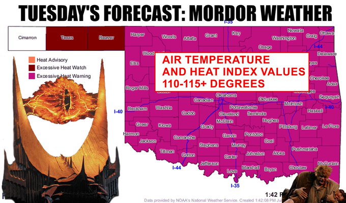
For the love of God, somebody throw that frigging ring into the volcano! Dangerous heat continues all week, but tomorrow looks especially brutal with possibly the hottest weather we've seen in a decade.
#okwx
#okmesonet
5
48
174
Lots can go wrong...not enough cold air, storm track continuing to shift south, unfavorable vertical temperature profile, etc. But confidence is growing that we will see impactful snow in Oklahoma Monday night through Tuesday. *Click for embiggenation
#okwx
#okmesonet
9
35
169
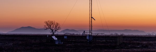
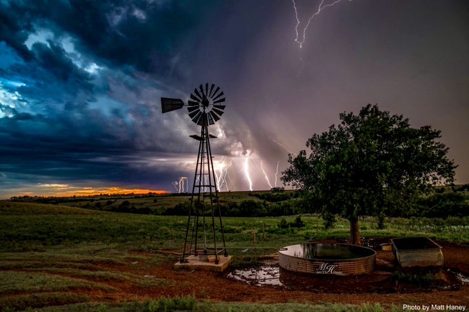
Photo was taken by Matt Haney by Leedey yesterday as severe storms roared in from the west, providing beneficial rains.
Beautiful shot from western Oklahoma!
#okwx
#okmesonet
3
50
169
Here's the full passage of the Dec 16-17, 2016 cold front through Oklahoma. Greatest temperature drops we measured in 2016.
#okwx
#okmesonet
3
130
164
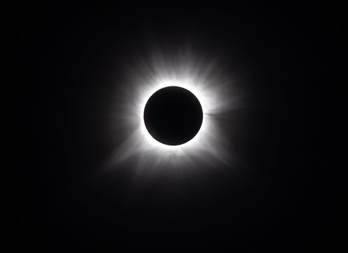
Stunning shots of totality taken at the Valliant Mesonet site in far southeast Oklahoma early this afternoon by Mesonet technician Steve Thompson. 😍
#okwx
#okmesonet
#Eclipse2024
2
28
171
What great weather we're having today!! Don't think it's great? Well, it's definitely better than what happened 2 years ago when Oklahoma was blasted with an ice storm BEFORE HALLOWEEN and more than 300,000 Oklahomans were without power!
#okwx
#okmesonet


12
24
167
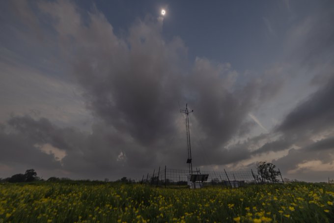
Here's a data animation of the eclipse as viewed from the Oklahoma Mesonet's 120 solar radiation sensors. 5 of our sites in far southeast Oklahoma reached zero solar radiation during totality.
#okwx
#okmesonet
#eclipse2024
3
38
167
B.C. Clark's is easy...true Okies will always have Tall Paul! Remember...524-1541? Tornado threat isn't zero today, so watch yourselves as well! Linda Soundtrack approves this message.
#okwx
#okmesonet
19
26
163
In the latest episode of "things you come across as an Oklahoma Mesonet technician"... honeycombs!
#okwx
#okmesonet
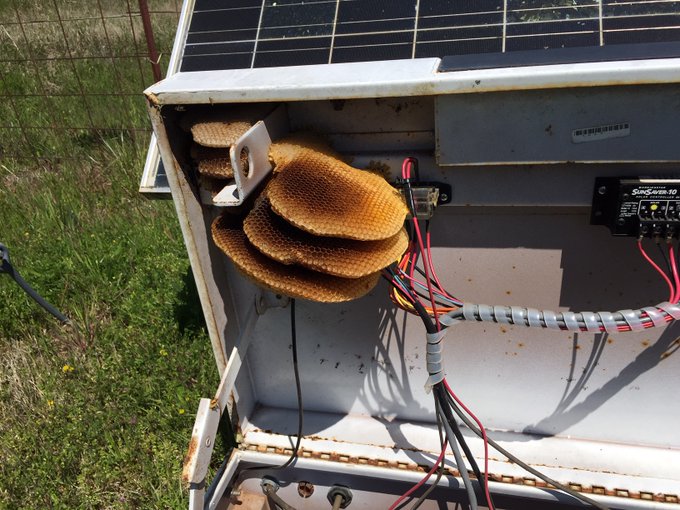
6
16
162
Have you been to White Sands, NM? That's okay. Today, it's coming to you. Here comes the dust!
#okwx
#okmesonet
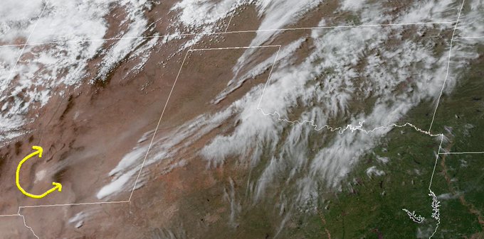
3
51
155
Mid-30s never looks so good! We'll see 50s and 60s on Thursday. That about covers winter for now, right?
#okwx
#okmesonet
3
13
162
Winter forecasts got you down?! 4 years of college calculus, ordinary (and partial!) differential equations, fluid dynamics, thermodynamics, synoptic, mesoscale, & computer programming classes await you! 🤪
#okwx
#okmesonet
7
43
155
Here’s the cold front approaching our Mesonet site at May Ranch up in Woods County. Even the moon looks cold!
#okwx
#okmesonet
4
18
160
The 95mph 10-meter gust at El Reno is legitimate. The site also measured 79 mph @ 2 meters as bow & embedded couplet passed over site.
#okwx

8
118
149
Just doing a welfare check on our neighbors
@NWSNorman
. We’ve got a chainsaw if you need one.
#okwx
#caughtintree
#okmesonet
6
6
159
We would prefer a Significant Cherry Pop-Tart event. Instead, we get the threat of a "significant severe weather day" according to SPC. The forecast will probably shift around a bit, so stay tuned.
#okwx
#okmesonet
5
32
160
Mesonet Ticker: No Mistakes
Maybe some rain today and tomorrow with the cold front, but the big drought relief comes in this weekend...and beyond! Remember, there are no bad forecasts, just happy little accidents.
#okwx
#okmesonet
5
25
158
Took Mother Nature long enough to open up the playbook! Fall weather returns Wednesday through the weekend.
#okwx
#okmesonet
4
16
159
Mesonet Ticker: Dirty Twenties
The flash drought started on June 11 and since then, we've seen the driest June 11-Oct. 5 in at least 100 years. The western Panhandle has fared better than anybody! Bizarro Oklahoma strikes again!
#okwx
#okmesonet
3
54
152
Hey, we could see highs for some in the *60s* later next week! But a good bet we'll see a lot of 70s, too. Fire up pumpkin spice madness!
#okwx
#okmesonet
5
17
155
Tired of the heat? Hey, don't worry, it's only 3 more weeks until we start our "normal" downward track to fall and winter. THREE MORE WEEKS? Yes, 3 more weeks. And no, it's not our fault.
#okwx
#okmesonet
11
30
153
Check out this time lapse view of 2 of yesterday's supercells captured from an experimental camera we have at the Washington
#okmesonet
site! 😲
#okwx
5
23
152
We're scouring the record books but we can't find a higher temperature ever recorded this late in the year in Oklahoma, dating back to the late 1800s, than the 95 degrees at Hollis today. The next-latest 95 on the books was at Coalgate back on Nov. 1, 1937. Wow!
#okwx
#okmesonet
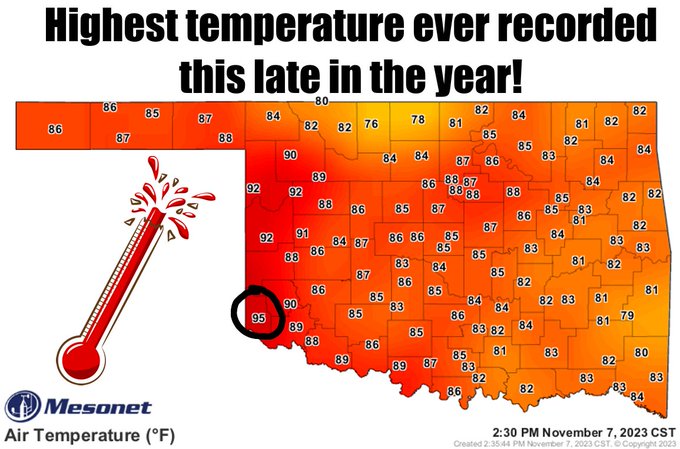
9
44
153
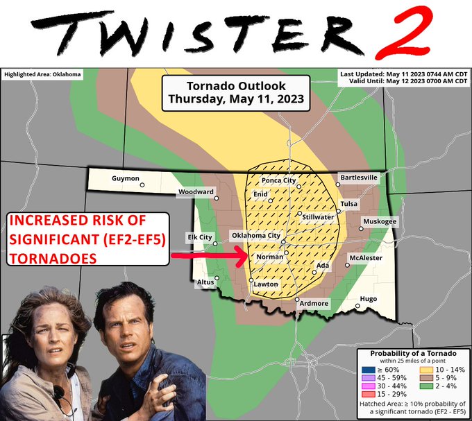
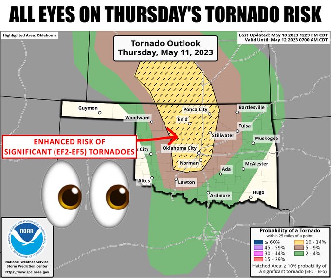
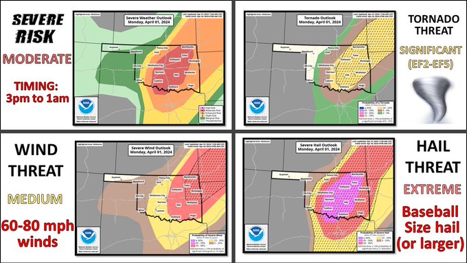
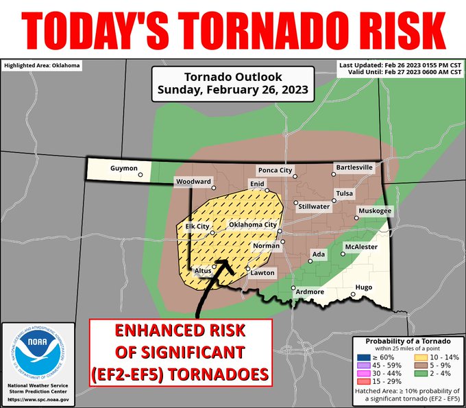
SPC has expanded today's significant (EF2-EF5) tornado risk to include more of north central Oklahoma and the western sides of the OKC Metro area. This risk will be in addition to straight-line winds of 80-110 mph possible on a much wider scale.
#okwx
#okmesonet
2
38
150
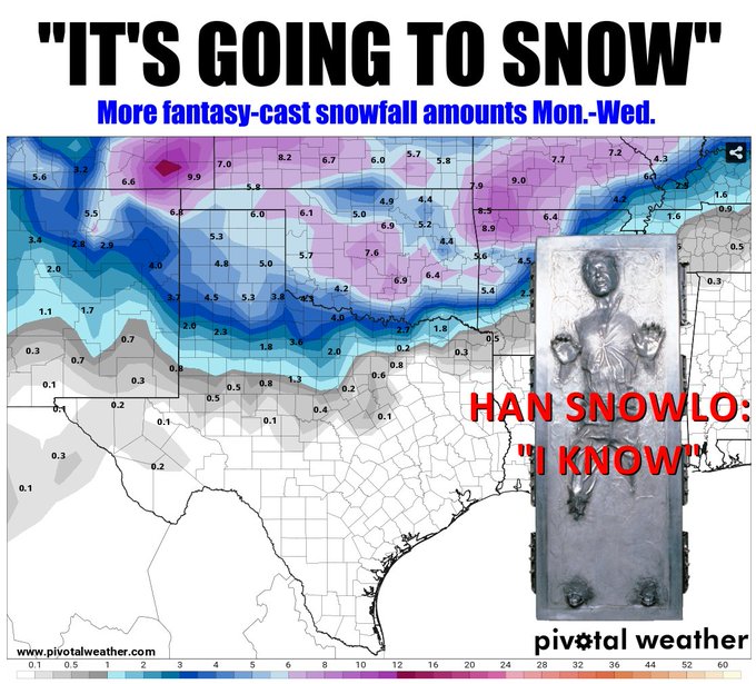
We're not gonna make that Obi Snow/Snowbi Wan mistake again! Confidence is increasing...might be going from fantasy-cast to reality? A bit of this up north is on Saturday...most is Monday night through Wednesday morning.
#okwx
#okmesonet
7
29
152

ICE! Just don't do it. Just say no! Tell them you're staying home, heck no you won't go!
#okwx
#okmesonet
5
70
149

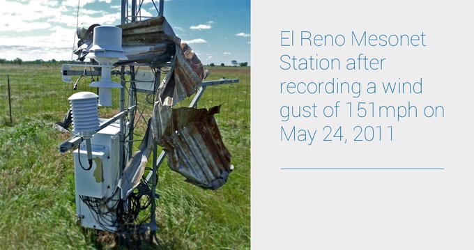
10 years ago today the El Reno
#okmesonet
site measured the strongest wind gust in state history as an EF5 tornado came close to, but did not directly strike, our measurement station. We measured a peak wind gust of 151 mph. Some data and a picture of the site. ⬇️
#okwx
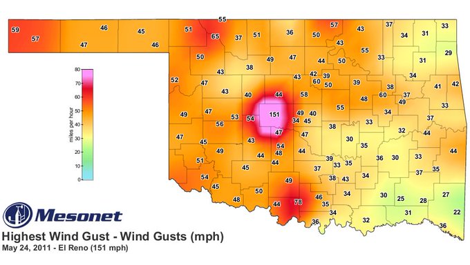
4
44
147
The geese overlords at the
@NWCNorman
sure have been keeping us all in our place lately

2
12
147
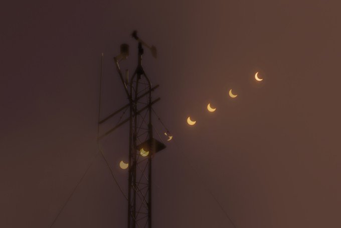
Watch as the moon's shadow passes by Oklahoma as viewed by the Mesonet's solar radiation sensors!
#Eclipse2017
#EclipseClimate
#okwx
4
88
145
With the power, vested in me as State Climatologist by the Weather gods, I hereby cancel Friday through next Wednesday. Can't see the numbers? You don't WANT to see the numbers! Click for embiggenation if you must, though.
#okwx
#okmesonet
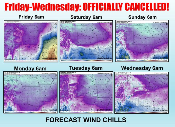
8
32
147
Yeah, he's cooking CHILI! Yes, with beans. YOU gonna argue with him? Anyway, this is just one model's view of a possible wintry blast for next weekend, so probably won't happen. It'd be a lot colder if it did, though!
#okwx
#okmesonet
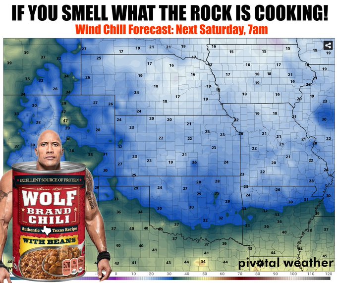
13
11
142
Mesonet Ticker: Just go away
Yes, we know it will get hot again...we're from here! But it won't be HOT hot. Next week switch our gears to FALL summer from SUMMER summer. We show you what we mean in today's Ticker.
#okwx
#okmesonet
5
24
144
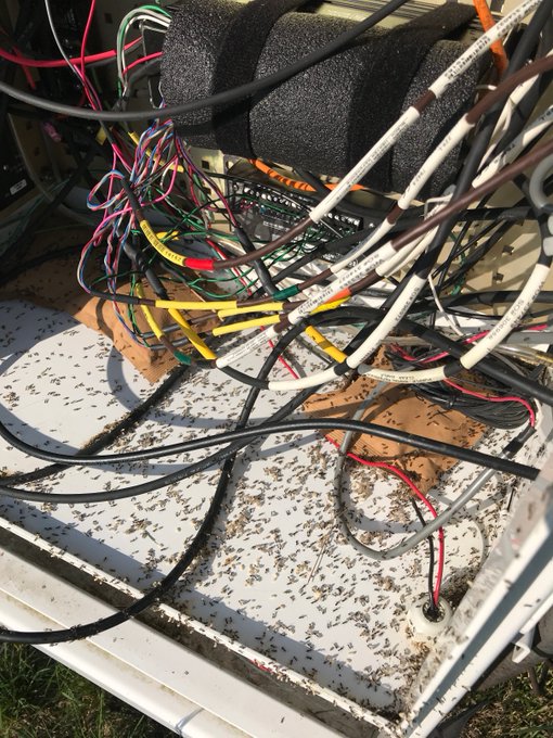
You know how sometimes the data from your favorite/local Mesonet site are not available? What's up with that you think?! Sometimes it's a radio issue, or power, or a lightning strike, or even cows doing damage. Well..sometimes it's ants in the electronics! Gross!
#okwx
#okmesonet

21
24
141