LauraNSotomayor🤠🦇
@lauransotomayor
Followers
1K
Following
6K
Media
241
Statuses
4K
🇲🇽|Ex-Athlete Hurdler🇪🇦|MITS Research🇦🇺|∆PhD goal_Geomatic Engineering @Sciences_UTAS~Ecosystem monitoring with #UAS #remotesensing with #AI #deeplearning
Hobart, Tasmania
Joined May 2017
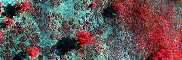
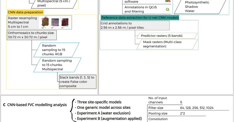
PhD paper is out🤠We advance methods for mapping fractional vegetation cover using a CNN-based U-net on cm-scale UAS RGB & multispec imagery, capturing patterns in sparse, complex vegetation & enabling detailed, scalable mapping in semi-arid ecosystems(1/8) https://t.co/c8HA1RI4u8
link.springer.com
Landscape Ecology - Monitoring fractional vegetation cover (FVC) is crucial for assessing ecosystem health and sustainably managing semi-arid rangelands. Field-based methods are resource-intensive,...
8
5
14

⛰️So happy to make it without walking and 10min faster than last year: 2:34:16 in this amazing half marathon 21.1km with 1271 metres elevation ∆ Average pace 7:23 min/km, starting with 5:50 min/km first 5km. @pointtopinnacle #P2P #kunanyi 👉🏻🐔😌👈🏻
0
0
0


now you can download trial version for free (so you can see if it works for you without purchase)

shipped https://t.co/iKXqU0zZ6O
@LabelmeAI
2
2
6
📢 AWARD ANNOUNCEMENT!!! @stefanopuliti @astrup_rasmus and @JohannesRahlf received the Special Contribution Award of the ISPRS International Contest on Individual Tree Crown (ITC) Segmentation! 🌳 @ISPRS SELPER Brasil @NIBIO_no 👉 https://t.co/KNEYQHa4DO 📸 Jörg Brauchle
1
2
12
📢 🥂 Introducing the newly funded Center for Research-Driven Innovation #SmartForest 💡🌲. A @forskningsradet funded project led by @NIBIO_NO @UniNMBU @UniOslo in collaboration with the 🇳🇴 forest industry and international partners @FPInnovations @ForestMistra RIF Institut 1/4
1
8
48

Find me another player in history who can do this... While serving out a TITLE. I'll wait. https://t.co/TJn4bz31H6
79
308
4K
A realistic and unbiased depiction of what the average day for a journal editor must be like.
1
31
232


Para cerrar septiembre: el dato que necesitabas ✨ La doble 🥇🥇 campeona mundial @garciaperezmari es la primera mujer de la historia en lograr dos oros en un mismo Mundial... dos veces seguidas. Y ojo: solo cuatro atletas en el mundo han hecho esto 👉🏼 Mo Farah, Carl Lewis,
2
47
196

Sydney McLaughlin-Levrone has the best husband and Dad combo out there! The mom is also alright😄 https://t.co/MgDCWvxT3T
7
129
2K
SYDNEY MCLAUGHLIN-LEVRONE IS THE 400M WORLD CHAMPION! 🥇 With or without hurdles, the Olympic Champ is unbeatable over 400m. #WorldAthleticsChamps | #RoadToLA28
58
1K
8K

Sydney McLaughlin-Levrone is the best in the world. Again.🥇 @GoSydGo wins gold in Tokyo with a new 400m Championship record time of 47.78.
17
207
2K
Heptatlón 🚺 Longitud @WATokyo25
@mariiaviicentee vuela hasta 6.10 m en su segundo intento (880 puntos) (su mejor marca de la temporada) Tras 5⃣ pruebas de 7⃣ 4584 puntos (13ª) #EspañaAtletismo #PasiónporCompetir 📺 @teledeporte / @rtveplay 📺 @Eurosport_ES / @streammaxes
0
8
62
𝑻𝒓𝒊𝒖𝒏𝒇𝒂𝒏𝒅𝒐 𝒃𝒂𝒋𝒐 𝒃𝒂𝒋𝒐 𝒍𝒂 𝒍𝒍𝒖𝒗𝒊𝒂 #EspañaAtletismo 🇪🇸 Entre las mejores del 🌎 MARAVILLOSAS 5ª ⏱️42.47 en 4x 100 m Esperança Cladera 🤝 @JaelBestue 🤝@paulasevilla7🤝 @Misabel_perez 👉 El mejor tiempo de la historia en unos mundiales 👉Igualan el
16
153
1K
Las Balas Rojas (quintas) cierran un gran Mundial @WATokyo25 para #EspañaAtletismo 3⃣ MEDALLAS 🥇🥇 @garciaperezmari🥉@PaulMcGrathinho 5º en el medallero global (el 2º mejor de la historia) 1⃣4⃣ FINALISTAS 👉2ª mejor de la historia 8º en el placing table global (el 3º mejor de
6
27
202
🏌🏻♀️Proud to share PhD project 'Mapping Ecosystem Resilience with High-Resolution Remote Sensing Data' was selected for the @nvidia Academic Grant Program 👩🏻💻Up to 1K A100 GPU-Hours on Brev🚀 #NVIDIAGrant #DeepLearningAlgorithms #ComputerVision #Robotics #GenerativeAI @NVIDIAAIDev
0
0
1