

josephkerski
@josephkerski
Followers
15K
Following
8K
Media
26K
Statuses
55K
Geography, geo-geekiness, STEM, ed tech, space, place, geographic information systems (GIS), GPS, outdoor education 365 days a year.
USA
Joined December 2008
Spatial Signals https://t.co/6533kDK4RG episode featuring me! Thank you all for inviting me and I hope my words are encouraging and useful.

americaview.podbean.com
Spatial Signals is a podcast about remote sensing, GIS, and geospatial technologies - but more importantly it’s a podcast about the people who use and apply them. This podcast is sponsored by...
0
0
0
Hiking Vibes on the Llano Estacado https://t.co/w3gXF59BLg via @YouTube for @gisday ! And @NCGE1915 geography awareness week @NatGeo
1
0
1
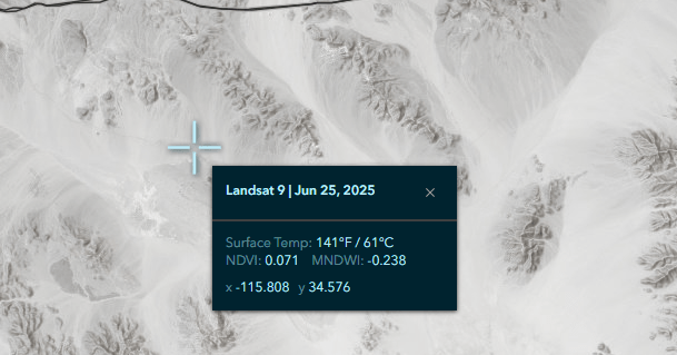
Landsat Surface Temperature Web Mapping Application and Data Now Available | Spatial Reserves
spatialreserves.wordpress.com
This Landsat Surface Temperature Web Mapping Application and data could be very useful in physical geography, environmental science, and GIS courses in instruction, and for research purposes: From …
0
0
0
One of my favorite projects of all time! Saluting the YouthMappers!

On 17th November, we will release our YouthMappers at 10: A Decade of Mapping for Impact Link: https://t.co/xi4nIpdPCR ...Over the past decade, @youthmappers has not only produced high-quality maps but has also empowered students to develop leadership... Stay tune👁️🫵🏾👁️
0
0
1
Feel free to share this set of maps with loved ones this #Thanksgiving ! https://t.co/WpbefNJrUN What I do with these is hide the THEME for each map and ask family to guess the theme - sweet potatoes? Turkey? Green beans? What items are grown in YOUR state? Enjoy!
community.esri.com
Greetings all and, if you are in the USA, Happy Thanksgiving. This “where does Thanksgiving dinner come from” story map: https://storymaps.esri.com/stories/2017/thanksgiving-dinner/ could be useful...
0
0
0
What do you mean, you didn’t include any metadata in your map? https://t.co/qPuhwIY59q via @YouTube
0
1
2
0
0
0
A short tour of the Rice Fields of Japan https://t.co/qFy2OOk9VC via @YouTube get out into the field!
0
0
0
In case you missed this, I have posted it as a story map on my website https://t.co/ZY0mVf57q9.
1
0
0
New phrases as to why geography matters - live stream https://t.co/PmAlT9HdmK via @YouTube
1
0
0
1
0
0
See you on GIS Day at the city of Midland and Midland College ! https://t.co/6PIPRMfbFy via @YouTube @gisday
1
1
4
Investigating the lowest points in Colorado and the average elevation https://t.co/s8Yc7XIUJi via @YouTube
0
0
0
Maxar retires its name, rebrands as Vantor and Lanteris - SpaceNews

spacenews.com
Maxar retires its name, rebrands as Vantor and Lanteris
0
0
0
Great to be at Metropolitan State University of Denver today speaking about Ai and GIS … Open to all!
0
0
0