
ICEYE
@ICEYEfi
Followers
53,129
Following
189
Media
1,375
Statuses
2,750
We manufacture and operate the world's largest SAR satellite constellation 🛰️
Espoo, Finland
Joined November 2014
Don't wanna be here?
Send us removal request.
Explore trending content on Musk Viewer
Amethi
• 219767 Tweets
राहुल गांधी
• 150449 Tweets
Knicks
• 147753 Tweets
علي النبي
• 64711 Tweets
Stacey
• 64208 Tweets
憲法改正
• 48430 Tweets
DONBELLE IN SOCCSKSARGEN
• 38634 Tweets
Reform
• 37590 Tweets
Hayırlı Cumalar
• 33252 Tweets
La ONU
• 32981 Tweets
स्मृति ईरानी
• 31131 Tweets
ゴジラ-1.0
• 25032 Tweets
#يوم_Iلجمعه
• 22215 Tweets
最終鬼畜妹フランドール・S
• 11101 Tweets


Did you know that ESA sponsors access to our SAR satellite data for researchers’ projects?
This is not just valid for archived imagery but also for new acquisitions over any location on the globe!
Check out our guide to learn how to apply: .
107
751
4K
ICEYE is providing the Government of Ukraine with access to its radar satellite imaging constellation. Read more on the agreement with
@CharityPrytula
in our press release.

151
729
4K
Hurricane Fiona reminded us once again of how big of a difference
#SAR
can make in effective
#DisasterResponse
.
With the world’s largest SAR satellite constellation, we enable insurers to immediately understand the situation on the ground — without waiting for clear skies.
76
519
2K

Truly effective
#ChangeDetection
requires
#PersistentMonitoring
. Learn more about ICEYE's unique
#SAR
satellite constellation and tracking capabilities.

59
191
2K
"InSAR can become a key way to monitor volcanoes worldwide. By analyzing the plumbing systems and fissures network of volcanoes, researchers can better understand hazards and risks. It can even potentially save lives." Freysteinn Sigmundsson of the Nordic Volcanologial Center
36
253
2K
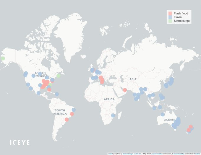
Global Flood Overview — Dec 15 🌏
Based on
@iceyefi
flood monitoring 👇
8 events: Observing event / weather
3 events: Flooding observed
1/3 flood events: Flood analysis ongoing
#FloodWatch
"
41
235
1K
#HurricaneDorian
has affected Bahamas heavily on Monday, with vast areas hit with
#flooding
, including the Grand Bahama International Airport, Freeport. ICEYE
#SAR
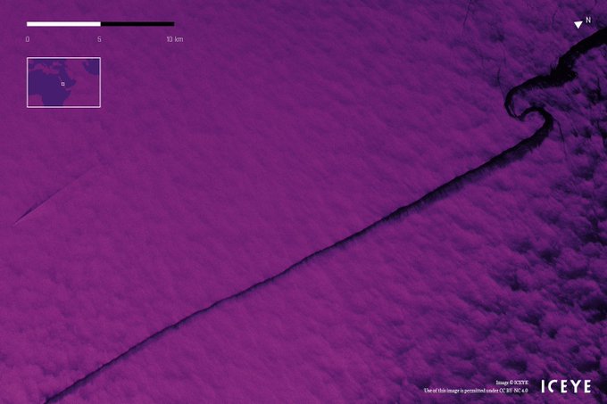
satellite image from 11:44AM local time. Please, stay safe! (Y: coastline. W: roads. Source: OpenStreetMap.)

40
962
1K
#PersistentMonitoring
with daily coherent
#SAR
satellite imagery -
@DarrenMuff
, Senior SAR Product Engineer at ICEYE, gives an excellent overview of this revolutionary capability. Watch the full film:
23
101
923
This series of daily
#SAR
satellite images shows a section of the 60-kilometer-long
#MuldrowGlacier
in Alaska demonstrating the forward movement of the ice flow highlighted in blue.
Read more about this world-first Daily Coherent GTR from ICEYE.
7
113
619
This time series of daily radar
#satellite
images uncovers that more than 50 hectares of forest area were cleared within seven days.
Read more about the world’s first Daily Coherent Ground Track Repeat capability:
#PersistentMonitoring
15
89
550
1/
#FloodWatch
— Fitzroy River in Kimberley, Western Australia, continues to flood from the aftermath of ex-Tropical Cyclone Ellie.
ICEYE's recent night-time radar satellite image shows significant flooding of Fitzroy Crossing, a town that reached record-high water levels.
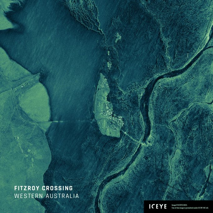
19
107
502
1/
#FloodWatch
— Record downpours from late last week triggered flooding across northern regions of North Island, New Zealand.
Below is a before-and-during flood depth and extent comparison for Wairau Valley, Auckland.
28
120
482
What is the main difference between optical imagery vs. ICEYE’s synthetic aperture radar (
#SAR
) data?
Unlike optical, SAR satellites can capture what is happening at night or under cloud cover.
See our overnight image as Hurricane Ian approached Big Pine Key in Florida.
11
71
469
Highlighted with black and white, see how molten lava spreads away from the primary volcanic cone of Iceland’s erupting
#Fagradalsfjall
volcano.
This series of daily radar images was taken with an ICEYE
#SAR
satellite.
More about Daily Coherent GTR:
9
59
375
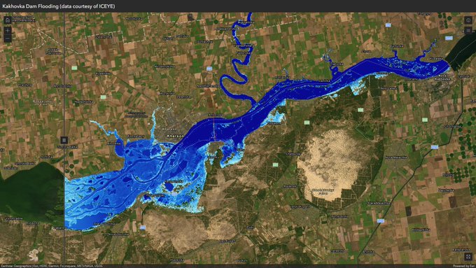
1/
#FloodWatch
in Ukraine
This analysis covers the full extent of the recent flood. Many towns and villages along the Dnipro River — Nova Kakhovka, Antonivka, Oleshky, Solontsi, and others — have been either partially or completely inundated.
5
108
327
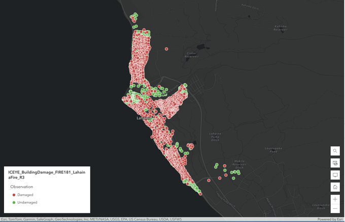
Watch our new video with Stephen Lathrope &
@shaybstrong
shedding light on ICEYE's Wildfire Insights product. Learn how insurers can benefit from near real-time building-level
#wildfire
damage assessment based on our SAR imagery that can be acquired regardless of clouds & smoke.
5
56
290
With
@ESA
, we piloted a new method for tracking rapid changes on Earth during last year's volcanic eruption on La Palma.
Read more about our project in our new blog post.

4
36
261
Available from ICEYE: Spot Fine imaging mode.
Take images of any area with a resolution of 50 cm with our next-generation
#SAR
satellites to get better intelligence by detecting the shape and structure of objects and zooming in to the component level for enhanced identification.
4
42
235
Make faster and better decisions with more confidence.
By staring at a point on the ground for 25 seconds, ICEYE's Dwell mode packs an unprecedented level of information into every image.
For details, watch our new video with
@DarrenMuff
.
4
42
227
Our Wildfire Insights provide timely info to emergency managers, helping prioritize resources where they're needed most.
Watch our video with
@AndyRead22
&
@shaybstrong
to see how we're revolutionizing public sector wildfire response.
2
42
219
Confirmed - ICEYE-X1 satellite communciations established! Launch success, Jan 12th, 2018. Read more here:
16
97
230
First ICEYE-X1 radar image from space published! Noatak National Preserve, Alaska, taken on Monday 15th, Jan. 2018 at 21:47 UTC. Read details here:
#radar
#SAR
#satellite
#X1
11
112
224
Confirmed - ICEYE-X2 SAR satellite has separated successfully. Communications with the satellite have been established at 19:58 CET, December 3rd 2018. Thank you
@SpaceX
@SpaceflightInc
! Launch success! Read more here:

7
66
220

Watch our new video with
@AndyRead22
and
@shaybstrong
who shed more light on ICEYE's building-level Flood Insights, and explain how we support governments and emergency managers with a new level of situational awareness for more effective public sector
#DisasterResponse
.
3
41
204
2/ Our team has produced two flood extent and depth analysis releases, observing thousands of buildings impacted by the flood.
See a before-and-during animation of the flood in Bronx, NY.
2
34
199
Discover how building-level observation data from the world's largest radar satellite constellation can empower the
#insurance
sector to shift from reactive
#DisasterResponse
to proactive customer communications and more effective claims management by watching our new video.
1
42
193
🌊 We have analyzed our 100th flood 🌊
To date, our team monitored hundreds of floods globally, mapping over 251K km² of flooded areas.
We continue to provide timely and actionable information to support disaster response and flood insurance efforts.
#disasterresponse
5
34
194
3/ Tropical Storm Hilary set all-time state rainfall records in NV, ID, OR, & MT, affecting 1600+ buildings in the Southwest.
Our team has produced the initial event analysis. Release 2 will be delivered to our customers today.
Reach out to get it: .
6
25
182
1/
#FloodWatch
in Scotland, UK 🌊
Storm Babet brought several days of rain to Central Scotland with 150-200 mm of precipitation in some areas, causing flooding.
See a before-and-during animation of the flood in Hilton, UK
3
35
189
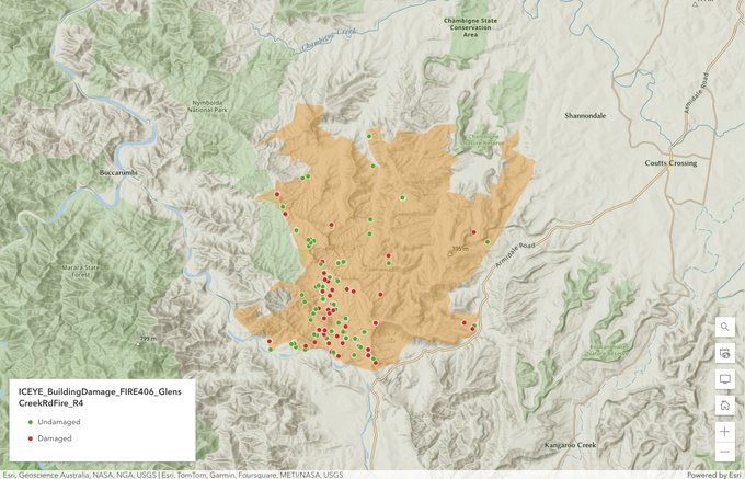

The collaborative effort between ICEYE and the Australian Government is set to enhance the disaster response & recovery activities for bushfires and floods, and also extend this transformative capability to agencies operating at both state and federal levels throughout Australia.
3
27
181
Whenever an oil spill happens, it’s vital to act fast. Our SAR satellite monitoring has proven stunningly effective in detecting oil spills, enabling a quick response and preventing environmental & economic damages.
See our capabilities in more detail 👉
1
32
169
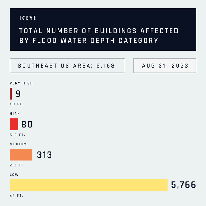
11/ Our latest Flood Briefing on the flooding from
#HurricaneIdalia
in Southeast US is available for download. In this report, you can access insights on flood extent, depth, and building inundation levels.
Get your PDF report here:
0
32
163
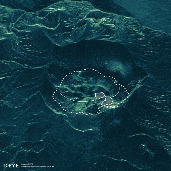
#TaalVolcano
's lake has almost disappeared due to the Taal Volcano eruption in the Philippines, as visualized here, based on ICEYE
#SAR
data from 16 January, 6:37AM UTC. Dashed line - waterline before eruption, solid line - waterline at the time of acquisition.
2
114
174
6/ See a before-and-during animation of the flood extent and depth in Hastings, Hawke's Bay, resulted from
#CycloneGabrielle
.
We continue monitoring and analysing the flood event; our next release will cover 5 more areas, including an update on Hawke's Bay.
4
32
163
5/ Thousands of buildings have been affected in the Mid-Atlantic area, US by this widespread flooding, based on our analysis. We've also mapped hundreds of impacted buildings in North Carolina.
The animation shows the flood extent & depth in Ocean City, NJ
3
41
156


1/
#FloodWatch
in California
We're monitoring the flooding in CA caused by two atmospheric rivers that brought more than 10 inches of rainfall to the state. 1,000+ buildings impacted.
The 1st release of our flood extent & depth analysis is ready; our team's producing release 2.
4
37
162
ICEYE’s data has helped to predict the location of the recent eruption of the Fagradalsfjall volcano in Iceland and to infer the depth of the lava. The data was used by the Iceland Met Office which is closely monitoring the volcanic unrest in the Reykjanes Peninsula.
2
57
153
🌳 ICEYE is dedicated to helping you take action against the destruction of forest ecosystems anywhere on Earth.
To find out how you can use our
#SAR
satellite technology to monitor forests, download our application study at .
#IntlForestDay
#ForestDay
1
35
148

Launch success! 🛰️🛰️ Today, July 5 at 05:41 UTC, two new ICEYE
#SAR
satellites have joined our previous units in orbit! Communications with both satellites have been successfully established. Read more:

3
59
155
What makes ICEYE’s new Dwell mode a game-changer?
It collects images over an unprecedented 25 seconds – you can extract unmatched critical information from a single image.
Discover the benefits of Dwell mode 👉
#NeverMissAThing
#SAR
1
25
144
Want to see floods & wildfires as they happen? Our SAR satellites capture near real-time imagery for early warnings & property-level analysis for
#NatCat
.
Read our blog on how to minimize losses and support recovery efforts with SAR: .
#RiskManagement

1
23
140
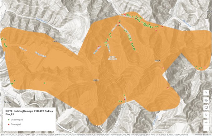
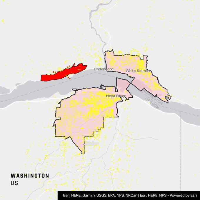
1/
#TunnelFiveFire
Our team is currently monitoring the Washington wildfires. At least 3 buildings within the wildfire perimeter have been affected. The fire spans 533 acres with 0% containment.
1
17
134
7/ 🚨Hurricane Idalia Update: see the number of affected buildings based on the first release of our flood extent & depth analysis, that's focused on the west coast of Florida.
3
32
129
Detect forest destruction with the world’s most reliable data.
🛰️ SAR satellite technology from ICEYE helps you monitor forest assets and respond to illegal activities. Learn more: .
#SAR
#earthobservation
#persistentmonitoring
4
31
140
ICEYE unveils its
#InSAR
capability! Read our press release to learn about the first demonstration of SAR interferometry from satellites under 100kg in mass:

3
48
137
1/
#FloodWatch
in the Pacific Northwest, US
Heavy rain and melting snow from the latest storm systems caused river flooding in WA & OR.
Our team is currently producing the 2nd flood extent & depth analysis release for this event.
Reach out for access: .
0
27
131
With ICEYE's $34M round B financing, the world's largest SAR satellite constellation is secured for deployment by the end of 2019.
#newspace

4
60
130
Today 29 Aug,
#HurricaneIda
hit the coast of
#Louisiana
as a Cat 4 storm.
#Ida
's
#landfall
was recorded with
@iceyefi
radar satellites.
#GrandIsle
, LA engulfed by water. Before: 02:42 am local. During: 10:41 am local. ICEYE is monitoring the storm's flood extent + depth.
4
61
132
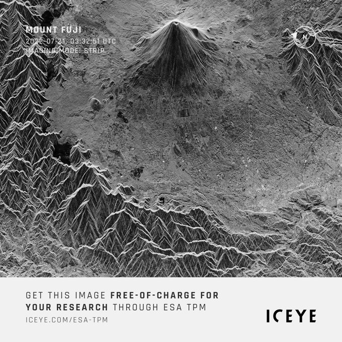
We are pleased to announce that ICEYE
#SAR
satellite data is now available through the ESA Earthnet Third Party Mission (TPM) for the global research community! Read more in our press release 👇

0
34
129
Imagine handling flood disaster management in a way that speeds up claim triage, expedites payments, and curbs late reporting of claims. With reliable Earth Observation data, this becomes a reality.
Discover how insurers can benefit from it in our blog: .

0
24
115
1/
#FloodWatch
in Alabama & Georgia
ICEYE observed widespread flooding caused by thunderstorms. Over 1,200 buildings have been impacted, with 100+ inundated with at least 8 feet of water.
The 2nd flood extent & depth analysis is ready.
Reach out: .
0
29
129

Global Flood Overview — Feb 1 🌏
Based on
@iceyefi
flood monitoring 👇
6 events: Observing event / weather
4 events: Flooding observed
1/4 flood events: Flood analysis ongoing
#FloodWatch
8
33
112
ICEYE’s second SAR satellite ICEYE-X2 returns its first radar image only 4 days after launch – now published and featured on
@CNBC
by
@thesheetztweetz
2
52
120
3/ We have produced the 5th (and final) release of the flood extent and depth analysis for
#StormCiar
án's impacts in Italy. Reach out to our team to get the full analysis: .
See a before & during animation of the flood in Pordenone, Italy.
2
23
118

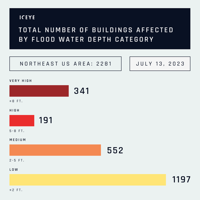
Our latest Flood Briefing on the flash flooding in Northeast US is available for download now. In this report, you can access insights on flood extent, depth, and building inundation levels.
Get your PDF report here 👉 .
7
27
100
1/
#FloodAlert
for Japan 🇯🇵
Heavy rains & flooding are possible in the Ryukyu Islands, especially in the urban areas of Okinawa, and over the southern and eastern coasts of Kyushu, Shikoku, and Honshu, as
#Mawar
passes by.
See our
#FloodEarlyWarning
map for the areas.

2
18
102
First 100
#SAR
images now taken with ICEYE-X1
#satellite
! 🛰 Includes our first look at ice, Lake Erie. This one is taken at 9:30 PM local time - quite a few hours after sunset.
#earthobservation

6
33
107
✅✅✅✅ 4/4, all
@iceyefi
#SAR
satellites successfully separated from
@SpaceX
#Falcon9
on the
#Transporter2
launch – Thank you
@Exolaunch
,
@SpaceX
, and congratulations to the full
@iceyefi
team!🎉
2
21
109
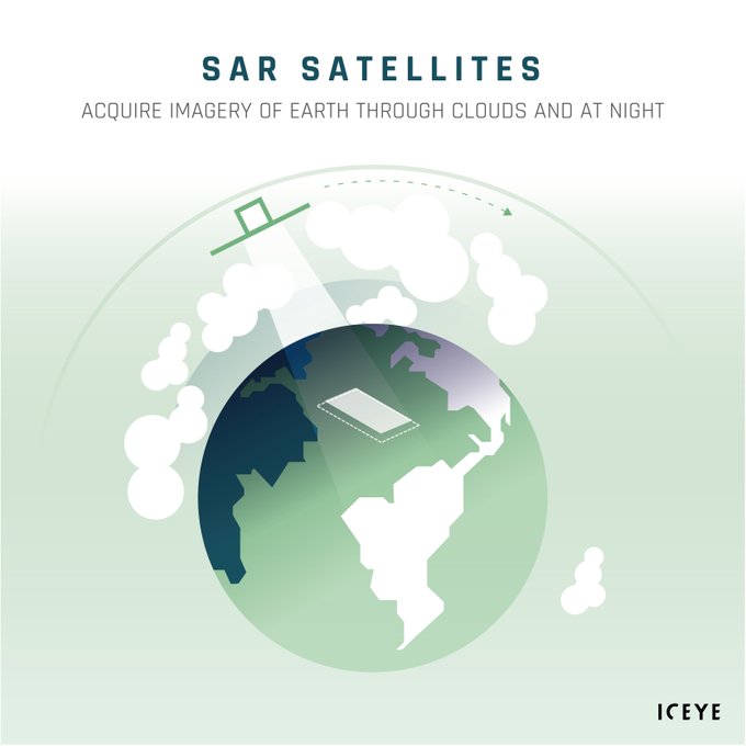
Did you know why radar is so important for
#EarthObservation
?
At any given time, most of the Earth is covered by clouds or darkness. This doesn’t stop our Synthetic-Aperture Radar (
#SAR
) satellites from capturing precise, high-quality images at any time.
1
18
104
4/ The coastlines in the West & North of France experienced flooding from
#StormCiar
án. Our team has produced the final release of the flood extent & depth analysis. Get access here: .
See a before & during animation of the flood along the Charente River.
2
13
97
5/ Our first release of Hurricane Ian's flood extent and depth analysis has been delivered to our government and commercial customers.
📷 An early view from Naples, Florida.
2
56
97
1/
#FloodWatch
— A major storm system has triggered significant flooding in Northern Italy.
The heaviest rain began on 16 May, bringing 125-150 mm to the northern Apennines and the Emilia-Romagna region.
The colors indicate the likelihood of
#flooding
Prediction date: May 15
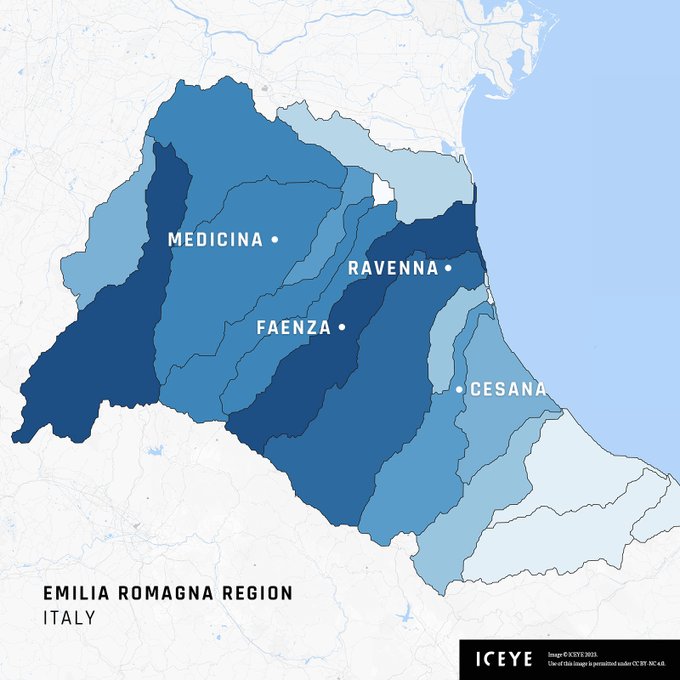
2
25
90
Monitoring specific sea routes or maritime areas is crucial for security and reacting to potential threats or illegal activities.
Download this application study to learn how our radar satellite imagery can help: .
1
11
84
We are excited to announce the Beta release of our Wildfire Insights product that provides near real-time building-level impact data for wildfire events.
Learn more in our press release: .

1
17
87
All our
#SAR
satellites have been separated from
@SpaceX
’s Falcon 9! Congratulations! Thank you to
@EXOLAUNCH
and
@SpaceX
for the successful launch! 🛰🚀
2
16
88
RT: "Today I received the first image taken by one of the Lessônia Constellation satellites from Mrs. Ana Paula Cordeiro, VP LATAM at
@iceyefi
. The satellites were launched in May 2022 in collaboration with NOSSA
@fab_oficial
. Soon, we'll start operating the 2 satellites."

Hoje, recebi da Sra. Ana Paula Cordeiro, VP da ICEYE (
@iceyefi
) para a América Latina, a primeira imagem feita por um dos satélites da Constelação Lessônia , contratado pela NOSSA
@fab_oficial
e colocado em órbita em mai/22.
Em breve, assumiremos a operação dos dois satélites.

15
49
427
4
15
80
ICEYE receives 10M€ grant from
@BusinessFinland
to establish Internet of Locations originating from Finland. ICEYE's total financing is now over $65M! 🛰️ Read more:

0
30
88
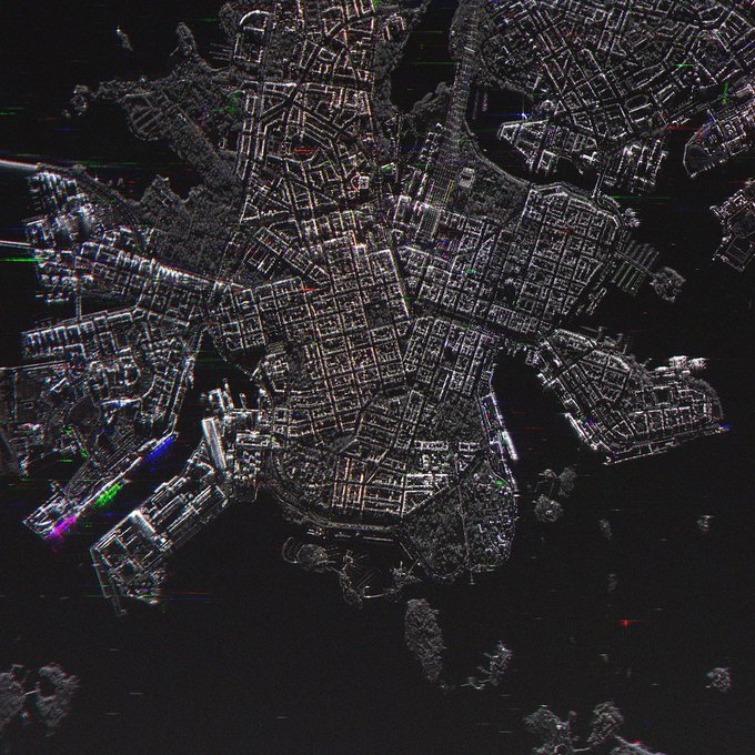
The world has its eyes fixed on
#TrumpPutinSummit
. Here's how central Helsinki looks like in change detection SAR imagery from ICEYE. Ships arriving and leaving between imaging times, trains coming and going.
#Helsinki2018
4
31
86
It can be extremely difficult to detect vessels on open waters.
Unless you are watching from space 🌏
Persistent monitoring helps you identify security threats or illegal activities and take rapid action.
Watch our video 👉 .
#marine
#earthobservation

2
17
83
Exciting New Space news for 2020: $87M Series C for ICEYE! Read the full press release for an update on future plans.
#NewSpace
#funding
#venturecapital
#satellites
#SAR

2
22
82
The collaboration between ICEYE and the European Space Agency grows further! ICEYE
#SAR
Satellite Constellation is now considered
@ESA_EO
's Third Party Mission under evaluation: Congratulations to
@planetlabs
and
@SpireGlobal
on achieving the same status!

1
22
82
When floods occur, it is critical for the
#insurance
and
#government
sector to respond fast and help people when they are most in need.
Watch this
#video
to learn how we deliver near real-time situational awareness.
#FloodMonitoring

3
7
75
The First Radar Image from ICEYE-X2 Published Only A Week After Launch. Imaged: Natural Parks Aralar and Aizkorri-Aratz, Spain on December 7, 2018 during night time.

2
36
81
Separation confirmed: all 🛰🛰🛰🛰🛰 of our
#SAR
satellites successfully separated from
@SpaceX
’s Falcon 9 rocket!
Thank you to
@EXOLAUNCH
and
@SpaceX
for yet another successful launch! Big congratulations to Team ICEYE — Go Team, Go ICEYE!
0
17
79
Watch our video with Nathan Uhlenbrock, our Solutions Architect, explaining how ICEYE's
#Flood
Insights empower insurers and
#EmergencyManagement
organizations to assess losses quickly and carry out
#DisasterResponse
efforts more effectively.
Learn more:
0
17
74
8/ 🌊Our team has produced the second round of analysis for this event, including the number of affected buildings and inundation. The 3rd release of this event is expected to be delivered today.
Follow our live updates: .
1
12
70
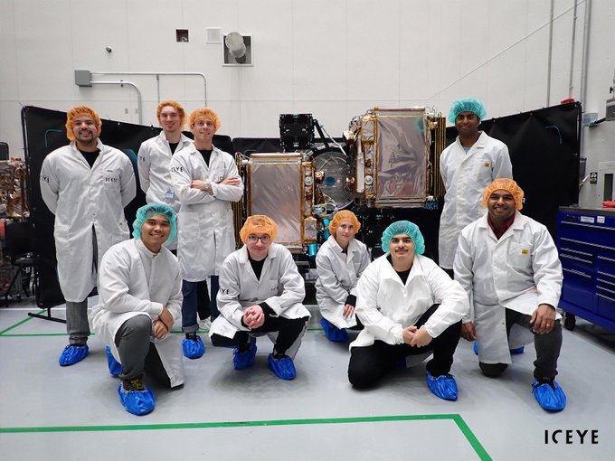
What a way to start the year! We're sending 3 SAR satellites into orbit on
@SpaceX
's Falcon 9, further growing our global constellation 🚀
Shout-out to
@EXOLAUNCH
& our fantastic team, who worked tirelessly to get the satellites ready for the launch!
2
13
79
ISRO, launcher of ICEYE-X1 satellite, confirms that ICEYE-X1 has been launched and separation now done. ICEYE working on establishing communications with the satellite.
5
39
78
We are honoured to be the first European
#NewSpace
company to join as a Contributing Mission to the
@CopernicusEU
Programme, the largest satellite Earth observation programme in the world!

3
25
77
4/ We've produced several flood extent & depth analyses and will continue to monitor the situation until it has passed. From now on, you can also follow our live updates on
#CaliforniaFloods
at .
📸Flood extent & depth (incl. buildings affected) in Pajaro.
5
10
67