Explore tweets tagged as #mapsofworld


Problem w tym, że odwzorowanie Merkatora tak zakorzeniło się w ludzkiej świadomości przez te setki lat, że nie mamy pojęcia, jak tak naprawdę wyglądają kontynenty i znajdujące się na nich państwa. Weźmy na przykład Rosję: wielka, co nie? No, duża. (mapka z mapsofworld)
1
1
323

Fascinující infografika z projektu Mapsofworld, jehož odborníci provedli podrobnou a pečlivou vědeckou a historickou práci. Na této mapě si můžete prohlédnout a spočítat všechny země v historii lidstva, které kdy vojensky vtrhli na část území světové jaderné mocností. Abyste
27
54
781

I move that this part of Indiana stops trying to be different and joins the rest of that column in the Central Time Zone as opposed to Eastern. No need for this type of nonsense. And who the heck drew that line? (Map from https://t.co/hxLDxkMrUJ)
0
0
2


Last week had both, birthday and day of departure of Simar. He worked tirelessly and left indelible footprints on the Web as pioneer of thematic portals, https://t.co/TXKsqR85bk & https://t.co/zpYmRtvyif. Though it has been three years, Simar is missed every single day.
7
5
8

This is the real and beautiful map of guyana.

Explore Guyana's unique geography and biodiverse ecosystems with #maps! Whether you're a student, researcher, or nature enthusiast, #MapsofGuyana is an invaluable resource for exploring this beautiful, biodiverse country. https://t.co/lufHGU3UUp
#Guyana #MapsofWorld
0
0
1
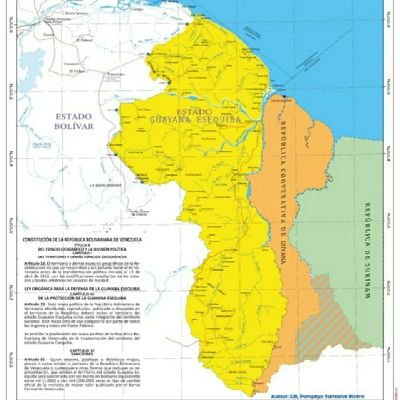
Él Esequibo es Venezuela
Explore Guyana's unique geography and biodiverse ecosystems with #maps! Whether you're a student, researcher, or nature enthusiast, #MapsofGuyana is an invaluable resource for exploring this beautiful, biodiverse country. https://t.co/lufHGU3UUp
#Guyana #MapsofWorld
0
0
1


WORLD MAP https://t.co/feBKX5B42O Language Map of the World https://t.co/1MBLUVLIgz A huge and helpful guide to 67 English speaking countries (and more!) 26 April 2023 https://t.co/hsALNyaZi2 Should English be the Official Language of the World? https://t.co/nf4At0ug7F
0
0
0

@corblanksma @Strandjunker A map of Europe in 1937 shows pre-WW2 boundaries, including Germany, Poland, and Czechoslovakia, viewable at https://t.co/C1jUza1dgq. The Nazis targeted various groups for concentration and work camps: Jews (six million killed), ethnic Poles, Roma, Soviet civilians, disabled
0
0
0

Занимательная инфографика от проекта Mapsofworld, чьи специалисты провели детальную и кропотливую научно-историческую работу. На этой карте можно увидеть страны в истории человечества, которые военным путем освобождали часть территории ядерных держав мира - выделено красным.
0
0
0

Инфографика от Mapsofworld, чьи специалисты провели детальную и кропотливую научно-историческую работу. На этой карте можно увидеть все страны в истории человечества, которые когда-либо военным путем освобождали часть территории ядерных держав мира.
0
0
0

#OTD 1653: New Amsterdam, the capital of New Netherland, the Dutch colonial settlement in North America was incorporated as a city. The city later evolved to become the modern-day New York City. https://t.co/MRqooFyhNH
#NYCHistory
0
3
7