Explore tweets tagged as #OpenLandMap

Interested in using Machine Learning to solve global environmental problems? We are compiling and distributing global training data set to enable soil, vegetation and land potential mapping - help us make better global maps #OpenData #OpenLandMap

0
56
122

اكتشف منصة OpenLandMap STAC:.خريطة تفاعلية تتيح لك الوصول إلى بيانات مكانية عالية الدقة عن التربة، الأرض، والمناخ. أداة مثالية للباحثين، المخططين، والمهتمين بالجغرافيا. جربها الآن:

0
0
26

🧭 Base de datos #OpenLandMap-soildb.Información global del suelo; 30 m. Basado en aprendizaje automático espacio-temporal y muestras de archivo unificadas. (2000–2022). Via GisArabi. 📄📂 💻
0
37
124
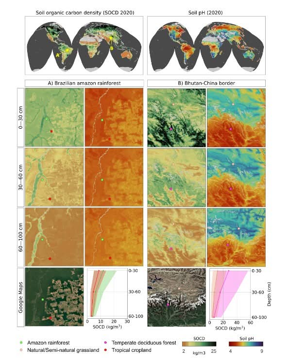
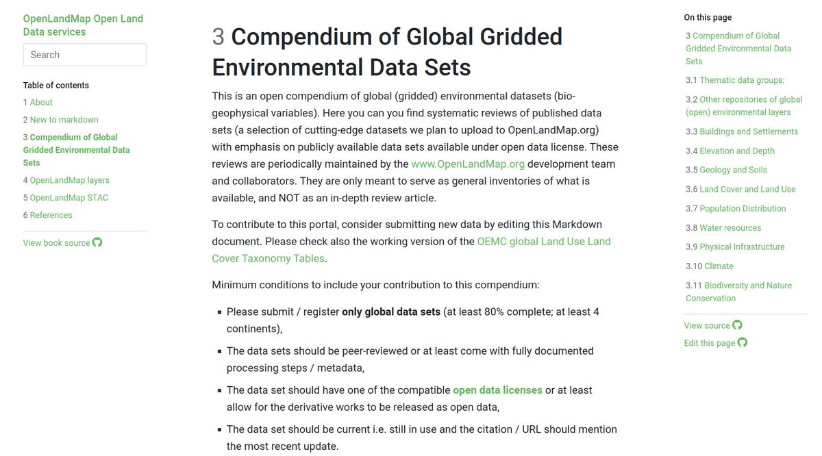
All global environmental (open) data sets listed at one place: .If you are aware of some relevant open global data set that we have maybe missed, please post here, or edit the document directly via Github. Thank you! @EarthMonitorOrg #OpenLandMap
3
80
241


We are testing using global compilations of soil profiles and HWSDv2 for predicting soil types (WRB). You can access all inputs and outputs here: If you are aware of some important soil profile dataset we missed, please let us know. #opendata #OpenLandMap

0
5
20

#OpenLandMap es un portal de datos ambientales abiertos a nivel mundial. El visualizador muestra servicios web de coberturas del suelo, vegetación o datos climáticos Para consultar la información ambiental de Andalucía

0
5
8

The aim of OpenLandMap is to not only just increase the usability of national and global data sets, but also at opening the floor for collaboration and data sharing. Watch our brand new interview here - See the below snippet from our case study:
0
0
0
🧭 قاعدة بيانات OpenLandMap-soildb.معلومات تربة عالمية بدقة 30 متر.للفترة 2000–2022+.تعتمد على تعلم آلي زماني-مكاني.وعينات أرشيفية موحّدة. 🔗 البيانات والمصدر:.📄 📂 💻

0
2
19

Africa’s soils hold the key to its agricultural future! 🌍🌱 Understanding soil texture is crucial for precision farming, water management, and climate resilience. It’s time to leverage this knowledge to boost food security? #SoilHealth #SustainableAg #SmartAg. Credit:OpenLandMap

0
3
4
📢 هل تبحث عن بيانات مكانية مفتوحة للبحث والتحليل الجغرافي؟.OpenLandMap يوفر مجموعة غنية من خرائط التربة والمناخ والتضاريس والنباتات بجودة عالية ومجانية! 🌍📊. 🔗 اكتشف المزيد:

0
2
41
If you are looking for global maps showing extent of cropland this might help - we interpolated & compiled @UMD_GLAD cropland product to 30m, 100m, 250m and 1km resolution covering 2000-2022: @EarthMonitorOrg #OpenData #OpenLandMap

0
3
45
Ensemble Digital Terrain Model & 15+ standard DTM parameters at 30m now available for testing as #OpenData 🌍: .Based on 30B training pnts (ICESat-2 and GEDI) and Copernicus DEM, ALOS World3D, and object height models. Preprint 📝:

0
58
218
Looking for #opensource land-environmental related data / global layers? Then have a look at the great data portal OpenLandMap @opengeohub!

0
9
16

Week 18 of EO Art: A look at surface temperatures (Jan-Jul diff, Apr-Oct diff, and annual mean). Not entirely satisfied with the oceans (lower resolution than land) or the overall projection. Using MODIS-based OpenLandMap for land and NOAA CDR OISST for ocean.


0
0
1
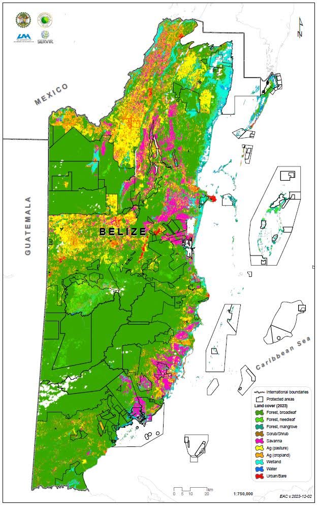
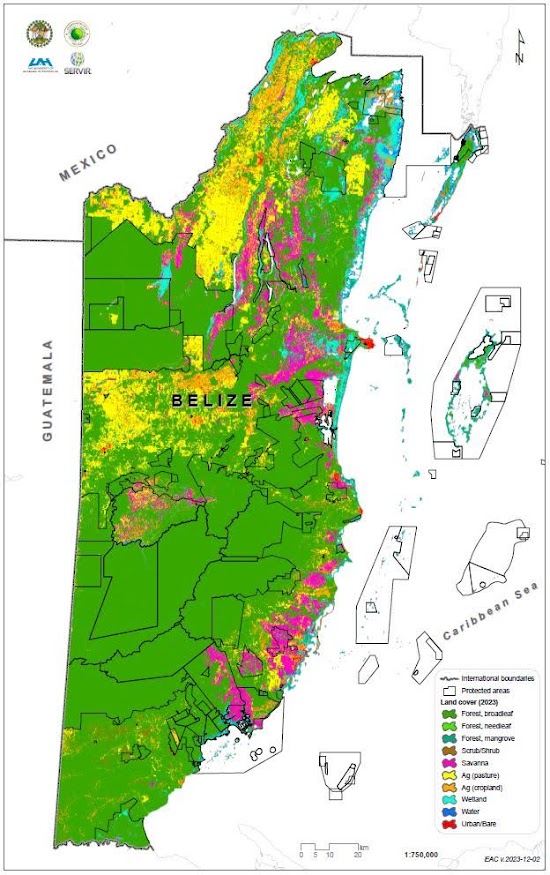
1/n: "Think globally, act locally." While we didn't generate #LandCover maps of #Belize w/ as extensive a #classification scheme as the recent #OpenLandMap data 👇, in July we did generate *2023* 🇧🇿 land cover data leveraging various iterations of #Landsat data + #EarthEngine.🧐
@GilabRs @EarthMonitorOrg The GLC_FCS30D annual land land-cover dynamic monitoring product (30 m spatial resolution) containing 35 land-cover categories and that covers the time span from 1985 to 2022. It is probably the most detailed long-term land cover data set to date. See at

1
3
16
Our planet / biosphere is constantly changing. Some recent trends (land and ecosystem degradation) are however worrying. Spend a moment visualization loss of natural habitats and consider what you could do to reverse some negative trends. #OpenLandMap.
0
8
26
MODIS LST monthly daytime and nighttime low (0.05), median (0.50) and high (0.95) temperatures for years 2000-2020 global at 1-km now available for download from prefer to use the Cloud-Optimized-GeoTIFFs? Refer to this tutorial:
1
6
25
Looking for soil information? Get access to soil chemical and physical properties + soil types by using the REST API. Development guidelines: #OpenData

1
9
48