Explore tweets tagged as #GeoVisualisation

Une belle géovisualisation de la NASA sur les courants océaniques à travers le monde.Le modèle utilisé provient d'ECCO-2. Les tourbillons formés par ces courants océaniques revêtent une dimension esthétique, presque picturale. On dirait du Van Gogh !

1
7
9
Le Cube cartographique, dérivé du célèbre cube de géovisualisation de MacEachren et Kraak (l'un des auteurs de l'ouvrage) organise l’ensemble des cas d’utilisation des cartes selon 3 axes : l’utilisateur de la carte, les tâches d’utilisation et l’interactivité de la carte.5/

1
0
1
La carte des accidents de la route en France (ONISR) : un bel exemple d'artefact lié à l'outil de géovisualisation en ligne.

1
2
6
La carte des accidents de la route en France (avec les tués et blessés recensés par l'ONISR) : un bel exemple d'artefact lié à l'outil de géovisualisation en ligne. Une heatmap par interpolation de points qui ressemble plus à une carte de densité de pop.


3
8
22

Environmental Management Course final contact session from 1-6 DEC 2023. Day 3: Participants' presentations, followed by an expert lecture on the "Geovisualisation of Urbanisation through AI & ML techniques" by Dr Setturu Bharath from Chanakya University. @EIACPIndia @ChanakyaUni

0
3
5
Al Gore indeed talks about Tom Van Sant's composite image of the Earth, stitched together from TIROS-N satellite imagery. It was an impressive piece of geovisualisation (first of its kind!)
1
0
3
📣La journée du master @E_Sigat aura lieu le jeudi 4⃣ mai sur le campus de Villejean !. 🗺📊L'occasion d'assister aux restitutions des ateliers de M1 et M2 avec les commanditaires et de discuter #géomatique #cartographie #géovisualisation #opendata . ➡

4
10
27


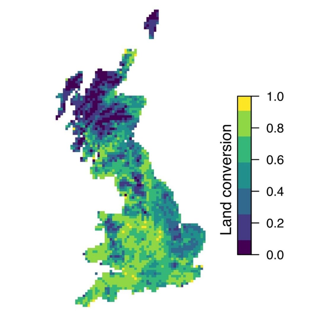
🗺️ Our latest geovisualisation is live, and it explores mapping land-use change in Great Britain over the 20th century. 🛰️. Read the full write-up here 👉 #Geovisualisation #Mapping

2
4
18
Data from @OrdnanceSurvey underpins many of the stunning images in our #Geovisualisation features. Find out more at:

1
11
55

#interested 😀 #learnmore about our #students & visit >lt; #EMJM Erasmus Mundus Joint Master #Copernicus #DigitalEarth #EO #GI #GeoDataScience #AI4EO #Geovisualisation #Geocommunication #universitätsalzburg #UBS #UPOL #Europe Master of Science

0
1
2
#applynow >lt; #study in beautiful #Salzburg #PLUS #Vannes @UBS_universite #Olomouc @UPOlomouc Master of Science #EMJM 2 years #ErasmusPlus #scholarship geospatial #MSc #Copernicus #DigitalEarth #GeoDataScience #Geovisualisation #EO #GI #AI4EO
0
2
4
Check out our #geovisualisation features to understand how stunning maps and visualisations help us make sense of our complex world, and convey unique perspectives of geographers:

0
5
13

🌍 Geovisualisation. 🪸 Social-ecological systems. 🌊 #Marine societal values. 🗺️ Fuzzy cognitive maps. Session three of #SMMRConf24 highlights a diverse mix of methods that show how we can view #MarineManagement from a variety of perspectives. 🔭


0
3
6

Offre de #postdoc @UMR_Passages pour le projet de recherche SPHEROGRAPHIA sous la direction de @geo_in_geo : #AnalyseDeDonnées #DataScience #géovisualisation #globesvirtuels #géographie #cartographie.RT appréciés

0
2
2
@MartaMeschini2 Through a systematic review, @chrisreilly0 of @HeriotWattUni investigates how we can optimise geovisualisation to build towards equitable decision-making by providing stakeholders with a visual representation of management and planning options. (2/6)

1
0
2
[#Ress_Num].🚶@mobiliscope 🚶 un outil de #géovisualisation qui donne à voir les variations de la population présente dans les territoires au cours d'une journée.👉

0
26
28
Find out how geographers make beautiful and insightful maps and visualisations of geographical data in our #Geovisualisation features - including ways that you can make similar maps!

0
3
10

TIL: @googlephotos has a map view of photos and I love the how the hotspots sum up my life in Bangalore - NID days, moving into a job, pub hopping and a few trips to Nandi hills!. #geovisualisation #dataviz #mapsinapps

1
0
4