John Cassidy
@earthquakeguy
Followers
7K
Following
9K
Media
2K
Statuses
4K
NRCan earthquake seismologist + UVic Prof. Works with engineers, emergency managers, and communities to minimize the impact of #earthquakes. My thoughts/tweets.
Vancouver Island
Joined October 2009
Did you feel shaking on Haida Gwaii today at 06:20 a.m.? That was a M4 #earthquake located 45 km WSW of Daajing Giids. It was mildly felt - no damage. Details: Please report shaking here:.


2
7
25
Are you looking for the latest updates on the tsunami from the M8.8 Kamchatka earthquake? See: and check with your local emergency preparedness group. As of 6:20 a.m. PT, July 30 the tsunami advisory for the coast of British Columbia has been cancelled.

2
10
38
What to do when you live on an island in the Pacific and you want to "get away from it all"? Well. you go to a smaller island in the Pacific! This one is beautiful Quadra Island. Hope to be back here soon.


5
1
30
Happy 15th birthday. Winston! A little slower now, but still the best!

3
1
32
Day 4 of the earthquake swarm at Mount Rainier. Follow updates from the PNSN:.and USGS:

usgs.gov
An earthquake swarm that started at Mount Rainier on July 8, 2025, is the largest ever recorded at the volcano.
1
4
22
Did you know that Canada is home to some of the youngest and the oldest rocks on Earth? .Youngest? ~150 years old, from volcanic eruptions in northwestern British Columbia:.Oldest? 4+ billion years old! .

cbc.ca
In 2008, Canadian researchers said they'd found the world's oldest rocks in northern Quebec. The find was controversial. But after more than a decade of hard work, they believe they've really proven...
0
5
18
June 23, 1946: Canada’s largest recorded #earthquake beneath land (M7.3) struck central #VancouverIsland. Shaking was felt from Oregon to Prince Rupert to the Alberta border. 100’s of landslides were triggered, chimneys collapsed, windows were broken. More

1
7
18
Earthquakes in eastern #Canada? June 23, 2010 - a damaging M5 #earthquake in western Québec was felt in Ontario, #Québec and as far away as Washington DC. It triggered landslides and produced the strongest shaking ever felt in #Ottawa (~60 km away). See:

0
2
8
Beautiful Quadra Island, a large cruise ship passing by, a warm June evening and a very late sunset. Absolutely perfect! .As seen from Campbell River on central Vancouver Island.

2
4
35
Wow! Is this an exhausted squirrel? Or a squirrel that just likes to lie in the sunshine?

5
2
20
May 16, 1976: a M5.4 #earthquake struck 60 km beneath Pender Island 🇨🇦 - a reminder that southwest #BritishColumbia is an active earthquake zone. High-rises in #Vancouver swayed for up to 30 s, windows broke in White Rock, and some power outages.

1
6
17
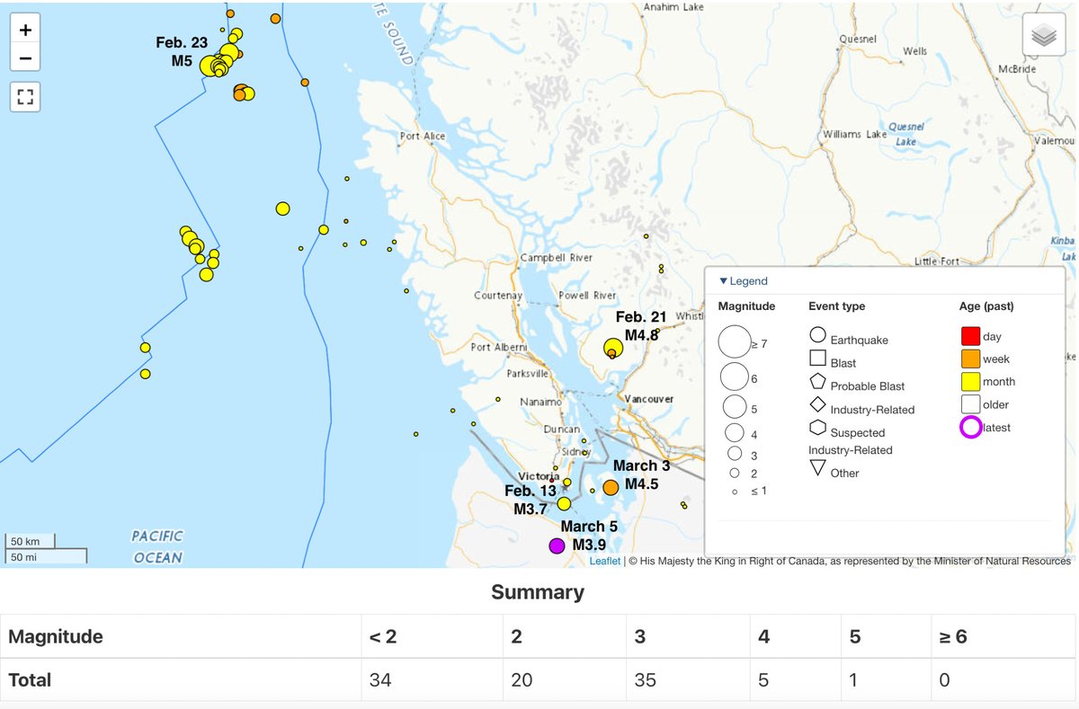
Did you feel shaking on #VancouverIsland at 11:49 a.m. PDT today? That was a deep M3.3 earthquake located about 20 km from #Ucluelet on the west coast (purple dot on the map below): .Please report shaking here:.


3
8
24
The Geological Survey of Canada (Pacific Geoscience Centre near Victoria, BC and Vancouver, BC) has an opening for a research scientist in Earthquake Seismology. Join a great, diverse team doing cutting edge science. 🇨🇦.Details: .Apply by 25 April, 2025.

2
13
30
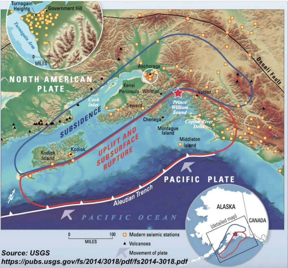
March 27, 1964 - a M9.2 subduction #earthquake struck southern Alaska. Shaking was felt across much of . British Columbia and Yukon and the resulting tsunami caused damage in some coastal BC communities. More (USGS): Video:
0
13
37
After the rain and the fog. finally, the sun and 16C. The magnolia trees are now very happy. #VancouverIsland


1
0
16
Well. the rain stopped but has now been replaced by thick grey fog. Not the best March ever here on southern Vancouver Island. but still lots of colourful flowers!


3
1
22
It is a grey, rainy day here on southern Vancouver Island 🇨🇦 - but we are surrounded by lots of colour. magnolias, camellias, rhododendrons, and so much more. #Spring is in the air.


3
5
33
Not here so often anymore, but I wanted to share this amazing rainbow with friends on this site. After a brief downpour on southern #VancouverIsland yesterday, the sun came out and this incredibly bright rainbow appeared over the Salish Sea. Attracted a lot of people on the beach

6
16
81
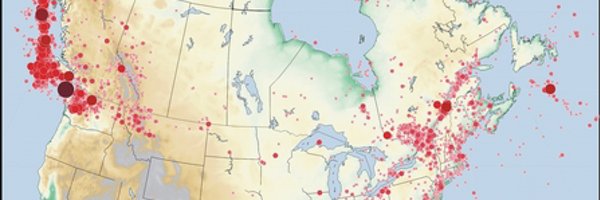
The common thing is that these earthquakes are in regions where we see tiny earthquakes (not felt) almost every day. These recent earthquakes are reminders of an active earthquake zone and the importance of preparedness. See: .
shakeoutbc.ca
Sign Up for ShakeOut, an annual earthquake preparedness BC event, and practice how to be safer during earthquakes: Drop, Cover, and Hold On.
2
0
9
With all of these recent felt #earthquakes, many people are asking "does this mean the big one is coming?". These quakes are not connected - some are shallow, some deep, all are on different faults and different tectonic plates and far from the locked subduction fault. So no.
2
25
75