
Cloud Optimized GeoTIFF (a.k.a COG)
@cogeotiff
Followers
2K
Following
252
Media
16
Statuses
223
I like to say that I'm like a regular GeoTIFF but in reality, I'm way better! Not a big fan of @JPEG_2000 #TeamCOG - gdal_translate -of COG
in the cloud
Joined June 2020
here we are:
Cogeotiff is going full remote (in reality it has always been). we now have a slack workspace
2
4
11
RT @howardbutler: @TheMrCam made a really useful thing for @hobuinc – a @CesiumJS provider that uses @cogeotiff for an on-the-fly terrain….
0
4
0
RT @cloudnativegeo: To help you navigate the expanding universe of cloud-native geospatial technologies, we’re excited to introduce the Clo….
0
32
0
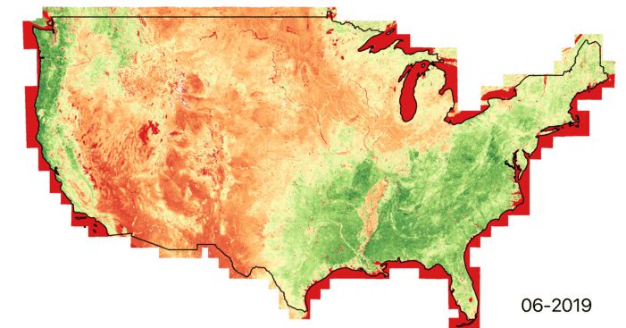
RT @postholer: How to retrieve pixel values from multiple rasters at a given coordinate in 1 line of code. It's easy. No @Esri , no #Pytho….
0
12
0
RT @pwramsey: Once again the most widely downloaded GIS software on the planet is reduced to begging for funding, in an amount that would b….

blog.qgis.org
QGIS turned 20 last year. Help us get ready for the next 20+ years by becoming a sustaining member! We want to ensure another 20+ years of sustainable development to keep on bringing the most user-…
0
78
0
If people need more context about Dynamic Vs Static tiling, here is a great article by Keith Ma from @Indigoag
medium.com
Post by @keithfma and @ceholden
I'm not sure I agree with this! I guess we have to do a better job at explaining what is a COG and what we can do with it. Let me start: COG is not a XYZ static tiles storage (well it can be, but it's not its best feature).
1
6
11
I'm not sure I agree with this! I guess we have to do a better job at explaining what is a COG and what we can do with it. Let me start: COG is not a XYZ static tiles storage (well it can be, but it's not its best feature).

A keynote from our CTO: 'Can We Please Stop Littering #GIS Protocols???'. Read on to learn how he argues that WMS, WCS, #ArcGIS image server and Cloud Optimized Geotif are harmful the field of GIS. 🤔.

5
3
27
RT @GeoSkeptic: Using @STACspec and @cogeotiff in @OurRadiantEarth MLHub, @jedsundwall lays out the MLHub goals in creating reusable and re….
0
8
0
RT @DoctorWho80: The slides presented at #FOSS4G2022 about the benefits of #COG @cogeotiff outside the cloud are available on https://t.co/….
github.com
Help documentation to build COG files with GDAL. Contribute to Doctor-Who/cog-recipes development by creating an account on GitHub.
0
6
0
RT @DoctorWho80: Version 🇫🇷 disponible sur le dépôt @Geo2France
github.com
Bonnes pratiques pour la génération de COG avec GDAL - geo2france/cog-tips
0
3
0
RT @DoctorWho80: If you want to know more about how to generate @cogeotiff with @gdaltips join me on .2022-08-25, 1….
0
5
0
RT @opengeospatial: We're formalizing Cloud Optimized GeoTIFF as an official OGC Standard, and seeking public comment on the standard. COG….
0
13
0
😍.

New Hilbert-based tile addressing and 75000x compression in PMTiles v3.
0
1
2
RT @OurRadiantEarth: Did you miss the lightning talks & tutorials on @cogeotiff, @STACspec, @zarr_dev & #COPC during the Cloud-Native Geosp….
youtube.com
@Cloud-Native Geospatial Outreach Event: The last few years have seen a quiet revolution in the way geospatial data is stored, processed and analyzed. Severa...
0
28
0
RT @satellitevu: Interested in Cloud-Native Geospatial Technology? One of our own, @James_O_Connor1 will be presenting on the use of stacks….
0
5
0