

Centre for Information Resilience
@Cen4infoRes
Followers
71,076
Following
841
Media
1,034
Statuses
2,142
Non-profit that exposes human rights & war crimes, counters disinformation, & combats online harms targeting women & minorities.
London
Joined June 2020
Don't wanna be here?
Send us removal request.
Explore trending content on Musk Viewer
XIAO ZHAN RISING MOON CONCERT
• 110974 Tweets
#光る君へ
• 100798 Tweets
Lewis
• 85949 Tweets
#ゲースト
• 80957 Tweets
#GameofSixTONES
• 77211 Tweets
Lando
• 68313 Tweets
ananの表紙
• 59384 Tweets
ジャック
• 56297 Tweets
Colapinto
• 48771 Tweets
ぱしゃっつ
• 34602 Tweets
#だれかtoなかい
• 30229 Tweets
#SingaporeGP
• 26999 Tweets
McLaren
• 25383 Tweets
ツイステ
• 21829 Tweets
コンパス
• 16351 Tweets
Albon
• 13635 Tweets
BBS KAI
• 11997 Tweets
Happy Fall
• 11894 Tweets
Fate復刻
• 11144 Tweets
一塁塁審
• 10211 Tweets


Pinned Tweet

Sign up to CIR's mailing list and be first to receive:
📢 Job Alerts (priority)
🕵️ OSINT Training (series)
🗓️ CIR Newsletter (monthly)
🚨 New Reports/Docs (priority)
0
3
9
A lot of footage is being posted online of Russian military movements along the Ukrainian border. We’re working with the
#OSINT
community to document, verify & map this information. You can find our map of verified movements here:
81
2K
5K
🚨NEW REPORT: Six months today, an attack on Kramatorsk rail station killed 59 civilians - including many children. They were attempting to flee.
Using
#OSINT
, our report shows how Russia was responsible for this horrendous act- THREAD 👇
18
478
1K
Sudan is on fire, and fighters are filming themselves, celebrating in front of burning buildings.
We have collected thousands of videos, posted to social media, and mapped fire damage across the country.
We can show you who is responsible.
17
918
1K


@planet
@Maxar
@ToasterIntel
Satellite imagery from
@planet
comparing between Feb 22 and Feb 27 shows multiple impact points of rocket attacks on Ozerne Airbase in Zhytomyr Oblast, Ukraine. Location: 50.159545, 28.745068


29
245
888
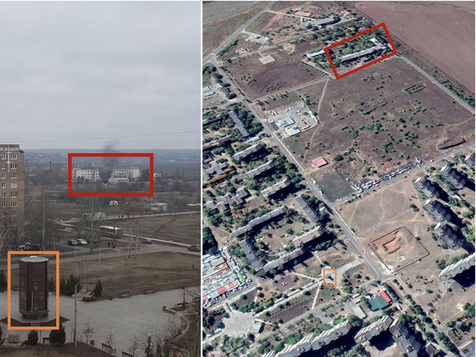
🚨New Investigation: Our Eyes on Russia team have verified the presence of a series of mass graves in the Yalivshchyna forest near Chernihiv.
1) Link below and THREAD👇

12
485
750
Over the past two months we have mapped more than 1600 videos & photos documenting Russia's invasion of Ukraine. We are starting this new thread to focus on the geolocation of Russian firing positions causing destruction in Ukraine. Our map:


16
292
650
Numerous grave lines added in each satellite image to this site in the Russian-occupied city of Kherson (Херсон) in Ukraine’s south. This timelapse of
@Planet
imagery shows grave lines added between 28 Feb & 15 April. Location: 46.669554, 32.530406.
13
355
614


Russia's full-scale invasion has devastated Ukraine's education system.
In our new film, we explain how, through open source, we're able to investigate, verify & map incidents - including hundreds of damaged & destroyed kindergartens, schools, colleges & universities.
See
23
341
588
This footage is not Ukraine. This is from Syria.


2
112
489
The town of Popasna (Попасна) in Luhansk Oblast has been subject to heavy bombardment as part of Russia’s war on Ukraine. This thread shows the heavy destruction, seen in
@Planet
satellite imagery from from May 20, 2022, compared with imagery from 2021.
The damage is grim.
11
290
497
We stand ready to assist German prosecutors as they investigate possible war crimes in
#Ukraine
, including the use of cluster munitions & targeting of civilians.
Working with our partners inc
@bellingcat
&
@mnemonicorg
, we've verified & archived a huge number of incidents.

Der Generalbundesanwalt ermittelt wegen Verdacht auf russische Kriegsverbrechen in der Ukraine. Unter anderem haben Berichte über Streubomben, Angriffe auf Wohnviertel und zivile Infrastruktur die deutschen Strafverfolger auf den Plan gerufen.
37
83
247
10
145
493
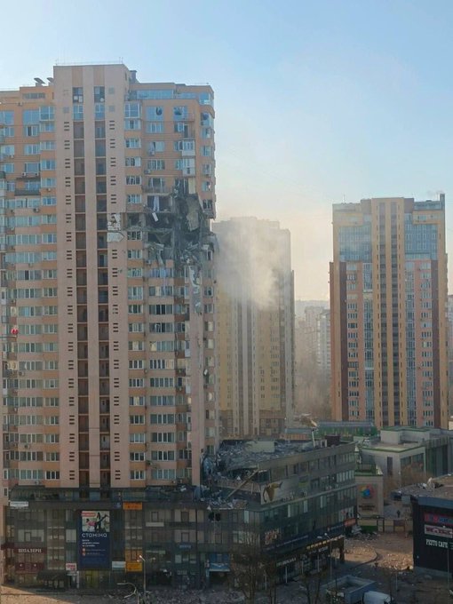
Geolocation of footage showing heavy fighting in Melitopol in Zaporizhia Oblast, Ukraine. The building attached is marked on its front as a hospital and the building seen is listed on Google Maps as the Oncology Center. Location: 46.839817, 35.371137.


❗️ In
#Melitopol
, the occupiers shot at the hospital
In the video, a shell hit the oncology department.
218
2K
3K
9
205
465
@sentinel_hub
@Maxar
@gfusfus
@Mike_Eckel
Satellite imagery from
@Maxar
shows Russian forces have established a camp in Ukraine at Chaplynka airfield, Kherson Oblast. Helicopters and vehicles have been deployed to the camp and entrenchments have been dug.
[Location: 46.3456885, 33.5413067]

34
213
425
It has been six months since Russia invaded Ukraine, and we have documented, verified and investigated each step of the way as the Kremlin pursuits a senseless war on Ukraine.
Here is a thread on what we have seen so far.
#EyesOnRussia
🧵👇
9
218
418
Geolocation of footage of downed Russian helicopter just outside of Kozarovychi (Козаровичі) in Kyiv Oblast. Location: 50.7605860, 30.3661308. H/T to
@L_ThinkTank
for location.
15
122
391
@Maxar
Satellite imagery from
@sentinel_hub
shows multiple fires burning today (Feb 26) around Gostomel Airfield in Kyiv Oblast, Ukraine. Location: 50.593381, 30.204936. H/T to
@il_kanguru
who identified this.


feb 26 multiple fires around gostomel airfield
50.593381, 30.204936

0
44
90
11
162
370

Our new and improved Eyes on Russia map is out now, allowing you to freely view verified information on what's happening in Ukraine 🇺🇦
You can view the map here:
More on this below.
9
146
354
🚨 With the U.S. presidential election fast approaching, X is struggling to tackle illegal content and disinformation.
In a joint investigation with CNN, CIR has exposed a network of X accounts using stolen photos of fashion influencers. These images have been manipulated to

16
218
375
Satellite imagery from March 1 of Luninets airbase in Southern Belarus, about 60km from Ukraine's border, shows large strike capacity including SU-25 attack aircrafts. Location: 52.277138, 26.782122. Imagery from
@Planet
.


12
176
349
@L_ThinkTank
Matching our two geolocations of two separate videos indicates a trajectory bound north for Vinnytsia Airport.
Geolocation 1 ()
Geolocation 2 ()

@L_ThinkTank
We have geolocated footage of a missile flying over Vinnyts’ki Khutory, Ukraine. Location: 49.197576, 28.540447


4
78
249
12
126
340
We're proud of how the
#OSINT
community has pulled together to map, verify and archive incidents during the conflict in Ukraine.
Here's
@BenDoBrown
on our work with
@bellingcat
,
@mnemonicorg
&
@CITeam_en

5
153
349
@planet
@Maxar
@ToasterIntel
Geolocation of large convoy seen today in
@maxar
satellite imagery 60km north of Kyiv. Convoy is facing south. H/T
@COUPSURE
for location: 50.891586, 29.976228

17
99
329
@L_ThinkTank
Geolocation of MRLS firing from Peremoha, Kyiv Oblast [50.498014, 31.259219]


MRLS firing from a village
Working on the geolocating the place.
89
2K
6K
14
123
306
UPDATE: New imagery available from today (15/4) shows the mass grave sites identified by our team at
@Cen4infoRes
in Chernihiv’s Yalivshchyna forest still growing. Location: 51.527611, 31.302965. 📸
@Planet
.
Report:
🚨New Investigation: Our Eyes on Russia team have verified the presence of a series of mass graves in the Yalivshchyna forest near Chernihiv.
1) Link below and THREAD👇
12
485
750
5
180
306
1. We are working hard to verify the fast-moving developments in Russia. In the thread below, we'll report reliable sources & post any content we've been able to verify.
#Russia
#RussianCoup
4
114
308
Alongside our partners, we will make available all information we're collecting, verifying and archiving to the
@UN_HRC
& other accountability bodies.
Huge thanks again to our volunteers & those who have donated 🙏


8
102
299
1/5 As open source investigators, we often witness horrific content online. Today, on
#WorldMentalHealthDay
, we share tips on preventing & dealing with vicarious trauma – the emotional toll of witnessing other people's suffering that can arise after engaging with graphic media.

3
126
298
📢CIR has reached the milestone of having verified 15,000 entries on our
#EyesOnRussiaMap
. These entries include verified footage of Russian military movements, civilian casualties and civilian infrastructure damage related to Russia’s full-scale invasion of Ukraine.
Thanks to
5
88
285
Geolocation of Russian artillery seen on
@Maxar
satellite imagery from March 21, in a field NE of Mariupol. Coordinates: 47.188128, 37.737440


5
119
279
Geolocation of thermal power plant struck in Okhtyrka, Sumy Oblast [50.316770, 34.876943]

4
101
275
🚨📝New investigation from CIR:
Digging in Danger: How Russian Forces Built an Outpost in Chernobyl’s Exclusion Zone
@BenDoBrown
looks into 🇷🇺 military activity at the nuclear site, including extensive digging of radioactive soil. ⬇️

11
122
274
We are continuing to collect, document, and verify evidence of Russian war crimes, human rights abuses, and military movements inside Ukraine along with our friends at
@bellingcat
and
@GeoConfirmed
. We have added 428 more entries to our map since 04 May.

3
94
279
A disinformation campaign has been underway over the last week targeting Ukrainians in Latvia. 1/10

6
153
257

CIR are monitoring the escalating tensions between
#Azerbaijan
and
#Armenia
. We have observed an increase in Azerbaijani military movement & activity at airbases.
Our investigators confirmed an increase in apparent military transport flights to Nakhchivan, an Azerbaijani

24
101
250
Geolocation of footage showing engine stage of a 9M79 Tochka 'SS-21 Scarab' Short-Range Ballistic Missile [OTR-21] in a residential area of Mariupol, Donetsk Oblast [47.112148, 37.553096]


5
96
250
@L_ThinkTank
We have geolocated footage of a missile flying over Vinnyts’ki Khutory, Ukraine. Location: 49.197576, 28.540447

Clearly a Kalibr missile, which was reportedly used for targeting the Vinnytsia Airport
#Ukraine
🇺🇦
8
96
234
4
78
249
Geolocation of missile strikes in Chernihiv [51.499511, 31.277672]

5
71
248
A number of accounts such as
@jacksonhinklle
are using low quality footage and deceptive analysis to suggest Ukraine hit their own children's hospital.
Here's how CIR investigators debunked these claims.
3
74
255
🚨Revealed: The Kremlin's Highway Killers - a new investigation into how Russian troops have targeted civilians⬇️
We examine
#OSINT
to piece together a string of cases where at least 18 people were killed along highways close to Kyiv - including nr Bucha

3
145
240
@sentinel_hub
@Maxar
@gfusfus
Satellite imagery from March 23 shows the only route out of the besieged city of Chernihiv, the bridge across the Desna river [51.457311, 31.301379] has been destroyed

10
84
239
You can view the 1000+ verified entries of footage and images on our Russia-Ukraine Monitor Map showing bombings, casualties and fighting here:

7
105
239
A Ukrainian military factory was bombed in Kyiv's east on the morning of April 16. How was it discovered? And who found its location?
Our new report shows how a pro-Kremlin Telegram group located the factory, and claimed responsibility for the bombing.

17
73
234
@planet
@LGalrao
Geolocation of footage showing a large impact hole in school, after a strike in Kharkiv [50.021103, 36.328125] Thanks to
@Michael1Sheldon


8
102
234
@L_ThinkTank
Geolocation of further footage of what appears to be a missile flying over Gnivan, Ukraine. Location: 49.092351, 28.338282


5
80
223


Russian artillery seen on
@Maxar
satellite imagery from March 17, in another field NE of Chernihiv. Coordinates: 51.596963, 31.440501

8
79
214
How do we verify this information? We use simple open source techniques such as imagery analysis & geolocation to confirm where, when and what is in the footage. For example, this is one of the videos we have verified:

2
74
204
Geolocation of destruction of Boiko Music School in the centre of Kharkiv [50.006521, 36.240386]

6
101
209
@L_ThinkTank
@john_marquee
@Danspiun
Geolocation of church Voznesensʹka Tserkva, damaged due to shelling in Bobryk (Бобрик), Kyiv Oblast [50.655507, 31.073123]


Orthodox church shelled by Russian forces in Bobryk, east of Kyiv

9
144
210
2
99
204
@Maxar
Geolocation of artillery strike on a hospital in Ukrainian-controlled Vuhledar, Donetsk oblast [47.775284253726696, 37.23941966817724]

Угледар попал под обстрел, попали в больницу, есть жертвы среди мирного населения.

5
66
36
5
106
201
We are going through the large volume of footage coming out of Ukraine today and adding it to the map. There is some graphic footage, so please read the descriptions before viewing any of the linked footage.


4
96
200
NEW REPORT: Mass graves after the Russian invasion: Bucha, Mariupol, Chernihiv, Kherson - shows the expansion of several mass graves and gravesites in Ukraine since the beginning of Russia’s invasion of Ukraine in February 2022.
Read here:

4
119
191
🚨 As the Ukrainian army continues to make gains against the Russian occupation, CIR investigators are continuing to geolocate & verify attacks on civilians and civilian infrastructure across the country.

2
49
185
Using open source analysis, our team worked with
@BBCPanorama
to identify over 1500 new mass graves in Mariupol.
Since the conflict began, we have verified over 4600 graves around the city. ⬇️

The agony of not knowing, as Mariupol mass burial sites grow
134
40
114
29
97
183
The Desna River Bridge near Zolotynka (Золотинка) in Ukraine's Chernihiv Oblast has been destroyed.
@Planet
satellite imagery from Feb 26 and Feb 28 shows the clear difference. Location: 51.371572, 31.209581


2
50
184
@Maxar
Geolocation of aftermath of alleged shelling in Borodyanka, Kyiv Oblast [50.659129, 29.966325]


2
59
180

@L_ThinkTank
Geolocation of a missile strike on a warehouse in Kharkiv [49.950587, 36.154536]


10
91
188
7
90
185
One of the important indications is what we see in
@Maxar
imagery at Bokov airfield, 40km from the border in Belarus. There is a significant increase of troops and large number of helicopters seen on the runway. Location: 51.985890, 29.160549


3
75
183
Our Russia-Ukraine Monitor Map now has more than 6000 verified entries of videos and images documenting Russia's invasion of Ukraine.
Anyone can view our map for free here:

3
70
180
@sentinel_hub
@Maxar
@gfusfus
@Mike_Eckel
A mass grave near the Church of St. Andrew and Pyervozvannoho All Saints in Bucha, Kyiv Oblast [50.548258 30.205485] seen on
@Planet
satellite imagery from March 21. The BBC reported on March 14 that 67 bodies that had been brought to the hospital in Irpin were buried here

5
98
174
The fake Sikhs
Most people assumed they were real. But CIR research revealed that a network of fake accounts was working to undermine Sikh activists, stoke cultural tensions, and promote Indian government narratives.
CIR Director of investigations, Ben

7
93
173
How Russia is deporting Ukrainian civilians - read our full report shared with the
@thedailybeast
here 👇


EXCLU: Russia has set up to systematically wipe out the Ukrainian population by forcibly “Russifying” hundreds of thousands of citizens, according to a new report extensively detailing Russia’s network of “filtration” camps for refugees.
15
152
198
5
94
172
🚨OUT NOW on
@VICE
- Debunking Putin’s Propaganda - how we are documenting, verifying & uncovering information in Ukraine, and countering propaganda. With
@BenDoBrown
.

4
74
172
@sentinel_hub
@Maxar
Hi-res images of the event we documented yesterday at the port of Berdyansk where a Russian vessel was struck. Location: 46.749655, 36.774893. 📸
@Maxar


Imagery from
@sentinel_hub
today shows a large smoke plume emerging from a port in occupied port city of Berdyansk. More information: . Location: 46.749655, 36.774893


7
25
103
1
77
175
1/5 📢NEW CIR report released on Russian shelling of medical facilities in
#Kherson
. Full report linked in thread🧵
3
101
177
🚨1/4 Yesterday, an apparent Russian 'double tap' strike occurred in the city of
#Pokrovsk
. According to the governor of Donetsk Oblast, the first strike occurred in the city centre at 19:15 & the second at 19:52 local time as rescue efforts were underway.🧵
4
63
172
A Ukrainian zoo posted this video of locals helping to evacuate animals. A month later, the zoo and remaining animals were bombed by Russia.
It’s not the only one. A number of zoos were shelled, cluster bombed, animals & caretakers - killed.
NEW REPORT
17
98
166
We have geolocated part of the footage claiming to show the withdrawal of Russian forces to Bakhchisaray train station, Crimea [180KM from mainland Ukraine]. The view can be seen here on Yandex Street View:


Russian troops head back to their permanent bases after successfully finishing military drills, Russian Ministry of Defense announces.
176
561
2K
5
78
166
🚨 As children, teenagers, and university students begin their school year, CIR has conducted an in-depth
#OISNT
investigation into attacks on educational facilities in Kharkiv, the second largest city in Ukraine.
Here's the report ⬇️ 1/ THREAD

4
89
168
We can cross-reference stills from the footage to satellite imagery to confirm this video was indeed taken in the town and filmed from this exact location.

2
46
152
Satellite imagery from
@planet
shows recent destruction of the Kamaryn Slavutych Border Crossing Bridge at the Ukraine and Belarus border here: 51.395485, 30.645746
Image on the left is from Feb 22, image on the right is from Feb 26.


3
58
153

@Maxar
Geolocation of missile hit around Ivano-Frankivsk airport [filmed from 48.897141, 24.715258]


4
66
153
13. Russian soldiers, purportedly VDV airborne forces, deployed on the M2 highway into Moscow, just north of bridge over the river Oka near Serpukhov. Location: 54.8823442, 37.510834


8
50
156
How did we find the location? Well, the name in the original tweet is a starting point, but proving exactly where it was filmed is a bit more tricky. For this, we use Google Maps & Google Earth to match features seen in the footage.

2
48
145
Geolocation of footage showing damage after a strike at the Children's hospital in Mariupol, Donetsk Oblast [47.096947, 37.533261]


4
72
147
If you are after geolocated and verified information of Russia's invasion of Ukraine and want to make sense of the overwhelming footage, our map is almost at 3000 entries and adding more every day.
Here's a thread on what some of the locations show 👇

2
64
148
Very concerning development seeing the buildup of new forces today from
@Maxar
satellite imagery.
A public road south east of Chojniki in Belarus has been blocked off and turned into space for a long line of helicopters. This is 150km north of Kyiv. Loc: 51.824667, 30.071583


5
68
153


Very grim footage showing the destruction of an area along the Hostomel's'ke Hwy in Irpin, Kyiv Oblast, Ukraine. Source: Location: 50.542320, 30.263943
1
93
147
More context on these graves can be seen below by
@Nrg8000
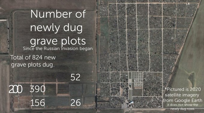
who identified earlier this month that more than 800 new grave plots had been dug at this site.


April 2nd satellite imagery of Kherson shows that the graves I've mentioned before () are still being dug. Since the beginning of this invasion, ~824 grave plots have been dug in Kherson Cemetery.
Given what we know about Bucha this is very concerning
55
1K
2K
3
59
145
🧵1/ Nine months ago today, Putin ordered the invasion of Ukraine. Since then, our
#EyesOnRussia
project has investigated, verified & documented thousands of incidents from the conflict.
Our Monitoring Map has over 6600 entries. It's free for everyone.

6
64
138
🚨 CIR is investigating, verifying & recording the continued targeting of civilian infrastructure in Ukraine, updating our map as we go. Below are just some of the cases we've verified ⬇️

4
55
136
7/8
CNN approached X for comment and notified them of nearly 60 fake accounts identified in this investigation. The platform did not respond. Read the story here:

3
63
144
1/ 🚨NEW REPORT: While Russia struggles to hold Kherson, one of the first conquests of its illegal war in Ukraine, we have uncovered the faces behind the occupation of the region ⬇️

2
63
142
7. Google traffic data shows that the M4 highway heading north from Voronezh towards Tula has been completely shut down.

3
40
140
There is a whole community of researchers, journalists, investigators and geolocators watching these movements, so we’re linking out to the source of that verification in the map as well.
Map:


2
42
137
🚨Revealed: How the Kremlin tried to discredit open source evidence of
#Bucha
atrocities
@BenDoBrown
shows how Russia used disinformation & denial to try & discredit open source footage & satellite data. Read the full report ⬇️

1
73
137


We now have 153 entries on our Russia-Ukraine Monitor Map thanks to the crowdsourced verification and footage uploaded by civilians and verified by our team. Here is the link: .

8
42
133
This central area in Popasna has a school, supermarket, pharmacy, businesses and homes. There is clear destruction in many of the buildings, some with large holes in them where there were bombs likely struck.
3
84
128
We've been documenting events in Ukraine since January, building a database and map of verified information and spotting disinformation when it happens.
Our latest report shows exactly how we're doing that, who is doing it, and why it is important.

2
60
132
Geolocation of helicopters flying over Gostomel [50.583768, 30.254727]


🇷🇺🇺🇦 ⚡️Another video from Gostomel, about 30 Russian helicopters moving forward
0
105
276
4
33
126
🚨NEW: A short explainer on Russia's "International Public Tribunal on
#Ukraine
" -
@elisethoma5
explains what it is, who sits on it, & why we should be suspicious.
Thread 🧵 and link below ⬇️

16
95
130