
Cameron Barker
@cabarkerwx
Followers
614
Following
3K
Media
970
Statuses
2K
| Meteorologist | M.S. University of Nebraska-Lincoln | B.S. Penn State | @Celtics ☘️ & @Arsenal ⚽️ | 📍MA | 11🌪️
Greater Boston
Joined January 2021
Peak gust at Blue Hill appears to be 90 MPH, which may be the highest gust there this century. Here is how it looked #mawx
15
33
163
Wind fields are not the most intense (~50 kt at 925 mb, ~60 kt at 850 mb). However, if mixing extends up to 60 kts as modeled, this will allow some really significant gusts to reach the surface. Favorable dynamics also in place with rather strong pressure rises (~6 mb / 3 hr).
0
0
5
(1/2) First high wind event of the season set for tomorrow night across a widespread portion of the Northeast as a dynamic clipper-like system moves through. In addition to synoptic wind, there is also the potential for severe wind gusts in "power showers" along the cold front.
2
1
17
[Damaging Wind Gusts Late Wed Night-Early Thu] A High Wind Watch has been issued for all of #SNE for late Wed night into early Thu morning. Westerly wind gusts of 55-65 mph expected between 11 pm and 5 am Thu. Tree damage and power outages expected.
0
43
157
Taking a look at last night's *surprise* wind event across portions of eastern MA, it is interesting to note several HRRR runs actually highlighted a brief period for rather strong winds, which verified. KBOS saw a pressure fall of 6.1 mb in an hour.
Just witnessed a few sets of power flashes in Middlesex County MA from a quick burst of 50+ MPH winds just now #mawx @WX1BOX
0
0
2
A small ribbon of 60 MPH winds as low as 500 feet off the ground, clearly most of this is being mixed down.
0
1
1
A brief but notable period of 50+ MPH winds occurred. Yet another spooky Halloween windstorm!
1
2
1
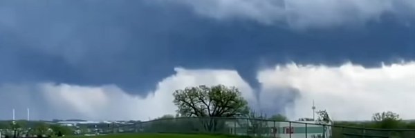
Full video from the 9/6/25 Massachusetts tornado event, showing my vantage point of the Berlin and Stow EF-1 tornadoes as well as stunning storm structure, finally uploaded: https://t.co/JfuKeG2EA2
0
2
6
I am thankful I was able to see as much as I did given the rain-wrapped nature of both tornadoes. It really goes to show how even subtle-looking lowerings can be tornadic in rain-wrapped situations, and the importance of radar data.
0
0
8
Here is the visual I had on the Berlin and Stow EF1 tornadoes. Local time at each photo matches when each was surveyed to be on the ground, therefore I can officially count these as my first New England tornadoes! I am amazed I viewed this 10 minutes from home in September. #mawx
3
9
33
Second bow echo down in the line packed a punch! Near severe wind gusts of 50-60 MPH estimated in Natick, MA along with near whiteout conditions #mawx
3
3
17
Well that was exciting! Beautiful rain free mesovortex base, with several interesting lowerings. Hard to verify what I was looking at given the rain wrapped nature but radar showed several possible brief spin-ups that I was looking in the direction of. #mawx
0
4
10
Best window for discrete supercells will be this line of radar returns across W MA/VT. The parameter space downstream is impressive, a borderline high CAPE-high shear one. Even if supercells do not materialize, a QLCS would pack a punch in this type of parameter space.
0
2
8
Latest suite of CAMs are at least hinting at some supercells along that prefrontal trough before upscale growth into a QLCS happens by late afternoon. Whether discrete or embedded in the line, I see a non-zero tornado threat given the parameter space, in addition to wind/hail.
0
1
7
(1/2) Still a respectable Northeast severe threat tomorrow. Big wildcard for me is a potential prefrontal trough, which would support a window for discrete storms in an unusually favorable Northeast parameter space. Quite high 3CAPE and impressive shear-CAPE overlap catch my eye.
2
10
48
Severe potential on Saturday is becoming apparent for the Northeast I-95 corridor. While no one parameter stands out, appears all ingredients will be in place with fall-like synoptics. Also some indication the region will be a jet streak right entrance region, favored for SVR wx.
0
9
68