
Christine Makena
@c_maken_a
Followers
202
Following
280
Media
12
Statuses
73
Tuk Geoinformatics student || Exploring the intersection of geography and technology 🌍 || Let's map the future together!😁|| @gssa_tuk former Secretary
Nairobi, Kenya
Joined April 2021
Geospatial data matters. It connects the dots between location, insights, and solution. Thus shaping smarter decisions for our world.
0
0
1
RT @c_maken_a: Make new friends while having fun.Join Meet and Mingle for a fun night out on 7th March with games,food,drinks,bonfire and l….
0
1
0

RT @Shadaya_Knight: Fellas:. Remember, even if it gets hard, it's what the best of men are made of. Hard times don't last, hard men do. Har….
0
351
0
The #RCTI2023GIS day presented a learning and networking opportunity for me. Delighted!Looking forward to the GIS day 2024.

Was a great day @RCMRD_ for the GIS day with @TheRCTI_RCMRD we really enjoyed it especially being from the @TU_Kenya we had a great time and it was an opportunity to learn and interact. Thanks @TheRCTI_RCMRD

1
3
15

0
11
30
#30DayMapChallenge Day 4:Bad map. This map tries to visualize the schools distribution in #Kenya using #qgis. The #Map does not conform to the cartographic design principles, hence the it does not serve its purpose which is communicating visually to the end users. #gischat

1
4
20
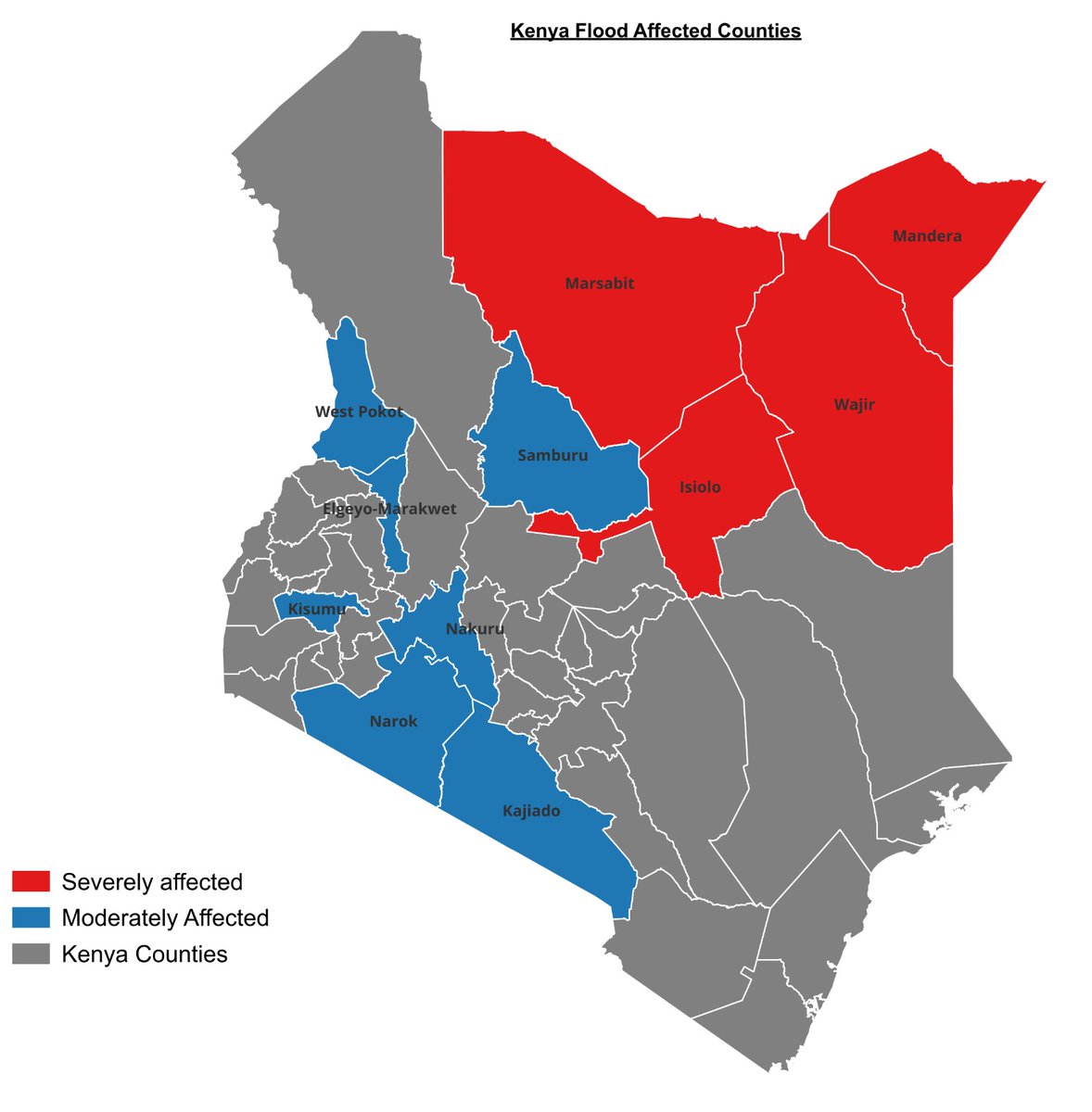
#30DayMapChallenge Day 3:Polygons. Counties in Kenya that have been affected by floods during the 2023 October-December short rains. Visualized on #QGIS .#womeninSTEM #gischat
1
6
48
#30DayMapChallenge Day2:Lines.Meru County contour lines map.Using Esri's Arcmap software.#GIS #rstats

6
16
68
I created an interactive #map showing #health facilities distribution in #Kenya using R. I added a tool for measuring distances from one health facility to another, helping users to identify the nearest facillities. #Novemberchallenge #day1


19
69
258
🎉 Last week I completed my @Esri spatial data analytics certificate! So excited to level up my skills! 🌍 #Esri #SpatialDataAnalytics

9
4
79

RT @Mose_Mwania: My first project in R; Computing NDVI from Drone Images. Monitoring crop growth and yield over time using digital photogra….
0
21
0

3
7
52