
Dr. Athena Masson
@Wx_Goddess
Followers
2K
Following
7K
Media
2K
Statuses
7K
#Meteorologist & Hurricane specialist. Creator of the Masson-Gough Hurricane Scale. #UofT PhD Graduate. Researcher & Professor. #NotaWeatherGirl
Florida, USA
Joined March 2016
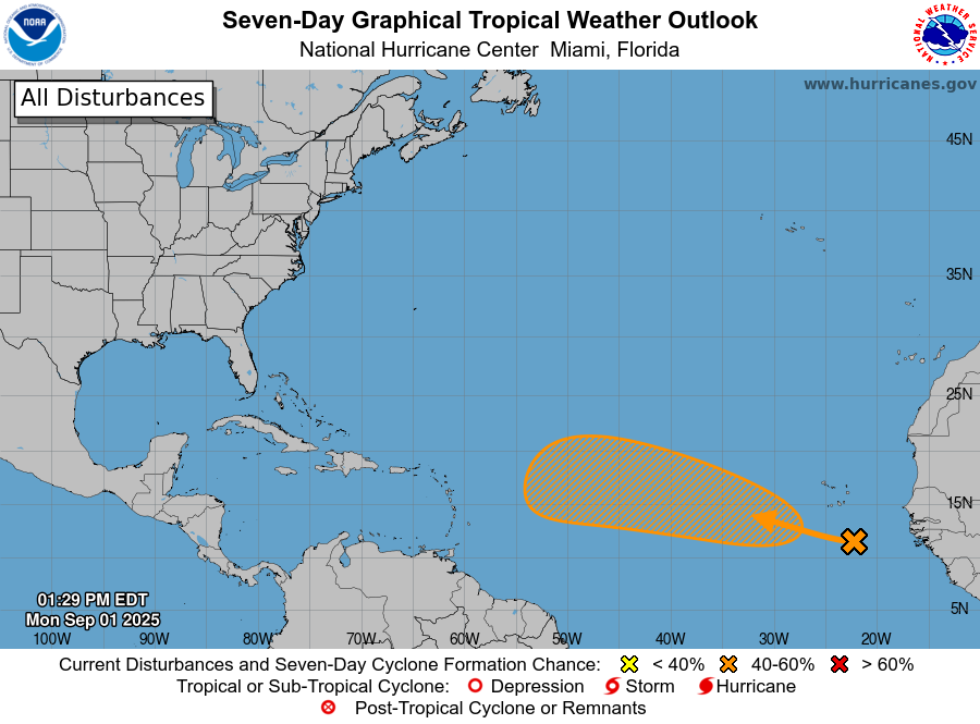
9/1 2pm EDT: A tropical wave over the far eastern Atlantic has a 50% chance of formation over the next 7 days as it moves westward to west-northwestward at around 15 mph across the tropical Atlantic. See https://t.co/tW4KeGdBFb for the latest updates.
21
312
1K
20 years since #HurricaneKatrina #Katrina became a large and powerful Cat 5 #hurricane in the Gulf before impacting #Mississippi and #Louisiana as a Cat 3 on August 29, 2005. Enormous destruction and significant loss of life. It is the costliest US hurricane on record. #wx
0
2
7
Friday, August 29 is the 20th anniversary of Hurricane Katrina making landfall along the U.S. Gulf coast and devastating the coasts of Mississippi and southeastern Louisiana. A lot has changed since 2005. In this video, NHC Warning Coordination Meteorologist Robbie Berg talks
7
100
349
Tropical Storm #Fernand Advisory 1: New Tropical Storm Forms South-Southeast of Bermuda. Expected to Remain Over the Open Ocean.
11
163
414

A large portion of the Atlantic coastline will see the risk for high surf and rip currents increase this week due to #Erin. 🟥Risk of Rip Currents is High🟥 Life-threatening rip currents are likely. Swimming conditions are unsafe for all levels of swimmers. Stay out of the

13
557
2K


While #Erin is expected to stay out to sea we are already monitoring another wave that has a moderate chance of development over the next several days. This one will be something to monitor closely as it is expected to track further south compared to Erin. Next name: #Fernand.#wx

8/17 evening: In addition to #Erin, the tropical wave in the eastern Atlantic now has a medium🟠chance of tropical cyclone formation within the next 7 days. The system should approach the NE Caribbean or SW Atlantic by the end of this week. More info: https://t.co/tW4KeGe9uJ

0
2
5

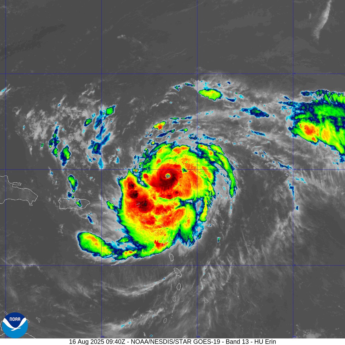
Last night, the 53rd Weather Reconnaissance Squadron flew into the eye of Hurricane Erin—and captured imagery of the breathtaking stadium effect. These missions provide critical data to the NHC to improve forecasts, helping keep communities safe before the storm makes
181
3K
10K
Aug 16: Images from @NOAA_HurrHunter and the @NOAASatellites Ocean Winds team show an intense eyewall in Hurricane #Erin This photo shows the ocean surface calm in the eye and roaring in the eyewall. For the latest forecast visit https://t.co/tW4KeGdBFb

74
1K
5K
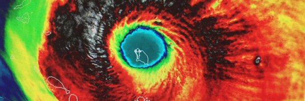
#Hurricane #Erin is now a Category 5 storm with wind speeds near 160mph. Pressure at 917mb & continuing to lower. Since 1924 a total of 43 hurricanes have reached Category 5 status. The last Category 5 was Hurricane Milton (2024). #wx
0
1
10
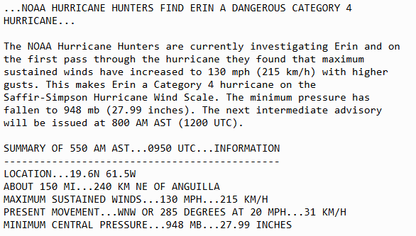
Aug 16 6AM AST: @NOAA_HurrHunter find #Erin has strengthened into a dangerous Category 4 hurricane with maximum sustained winds of 130mph. Stay up to date with the latest forecast at https://t.co/tW4KeGdBFb
39
507
2K
#Hurricane Hunters continue to monitor the progression of #Erin. Expected to strengthen over the weekend and has a chance of becoming a major hurricane (Cat 3+) as it moves north of the Caribbean Islands. Latest loop of convection showing an eye trying to form. 👁️ #wx
0
0
4

As #Erin becomes a formidable hurricane over the western Atlantic, the Bahamas Archipelago will shield our waters & beaches from most of the wave action associated with the storm. Still, surf & rip current risk may become elevated on our northern east coast beaches next week.
18
91
243
#Erin becomes a #hurricane, the first of the 2025 season. On average the first hurricane of the season forms around August 11th. Parts of the northern Leeward Islands are under a Tropical Storm Watch. The core of Erin is expected to pass north of the islands this weekend. #wx
0
1
4
7AM CDT 8/15: The system off the coast of northeastern Mexico and southern Texas coastline has a medium (50%) chance of becoming a short-lived tropical depression before it moves inland later today. Regardless of development, locally heavy rainfall is possible over the next

9
157
494
We are entering the peak weeks of the Atlantic #Hurricane Season today. August 15 - October 15 is generally the most active time for tropical development, with the statistical peak being Sept. 10. Continuing to watch #Erin, which could become a hurricane later today. #wx


0
2
8
#Erin strengthening in the Atlantic as it gradually moves westward. Expected to become our first #hurricane of the season. While a gradual turn northward is forecast, tropical storm force winds will likely occur across portions of the #Antilles this weekend. Monitor closely. #wx


0
0
2