
Gabe Garfield
@WxGabe
Followers
14K
Following
39K
Media
2K
Statuses
13K
Meteorologist & storm chaser | Helping chasers find tornadoes | Posts about tornadoes, forecasting, and science | https://t.co/npFjOV1U1o
A-Z tornado chasing course ⬇️
Joined September 2013
FYI I'm running a special pre-season deal on my online tornado course this month. Gotta get everyone ready for storm season! Check it out: https://t.co/T6jpwn7eU4
1
0
8
Storm season is less than 5 months away. (But who's counting. haha)
0
11
136

“I've taken that same anointing upon Ronald, speaking of Ronald Reagan, and I've put it upon my Donald .” @TheElijahList @ElijahStreamsTV
0
0
1
Pretty cool to see how far the Indiana football team has come!
0
0
10
Ah, there’s a 5% tornado in Tennessee. I live in Tennessee. 👍 It’s my wife’s birthday. 😩
11
3
86
Recently, I studied a few chase days which had outflow boundaries as primary targets. The big difference between tornadic and non-tornadic events? How fast morning storms dissipated / left the target.
4
3
56
My last video for this week is up! For the first time, I tell the full story of how I started tornado chasing. Spoiler: I wasn't very good for a long time. haha (Link below)
3
2
15

Most companies chase no-code. These guys did the opposite. Instead of replacing engineers, @timgdelisle & @chriscrane, Co-Founder Fiveonefour, built tools that make devs 10x faster. Here’s what we discussed: • Why “developer-first” beats “no-code” • How simplifying code
0
3
21
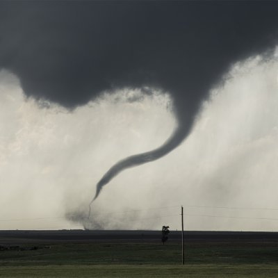
This was the 1300 UTC Day 1 Outlook the day of the 90-minute Bennington, KS EF4 tornado in 2016. It's the kind of day that makes you chase 50 marginal outlooks in the future. haha
6
10
125
Next episode in the YouTube series is live! This one focuses on what makes tornado chasing dangerous. Would be curious to hear your thoughts! (Link below)
1
4
14

The new vid is up! And please let me know what other topics you'd like me to explore. 👍 https://t.co/pC2b3vrjpo
5
10
52

Here it is! The 2026 NSCS schedule! (Subject to change on all aspects) Get your tickets at https://t.co/dnwuKAIXa5
8
35
95

You may have noticed that I’ve been a little quiet on X lately. The truth is, a few other things have captured my focus of late: My third kiddo, who was born in September. (Sleepless nights. 🥱) A minor health struggle in early October. (All better. 👍) And a little more
21
13
155

Hedera’s Hashgraph replaces blockchain’s linear chain of blocks with a Directed Acyclic Graph (DAG), where transactions confirm each other asynchronously, similar to how news spreads by word of mouth The result: parallel consensus, sub-second finality, high throughput & low fees
0
35
390
I’m not a hurricane chaser. But this is the kind of view that makes me question that. 😮💨

A thread of videos from today’s flight into Hurricane Melissa In this first one we are entering from the southeast just after sunrise and the bright arc on the far northwest eye wall is the light just beginning to make it over the top from behind us.
2
4
127

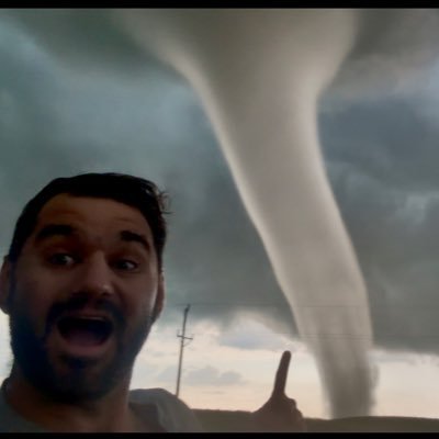
Flash warning. Beautiful non-tornadic supercell near Holdredge, Nebraska, from back in 2023
10
167
1K
NEW FOOTAGE‼️ I have not released yet, I believe @ben_williams_wx asked about the video of our Close Range of Clear Lake, SD… Just @Tornado_Warned and I, and @alex_bartwx just behind us.. Nobody else around at this stage. So awful about releasing video, most of my footage
10
36
262

Victor Davis Hanson: America Fought a Civil War So Trump Could Enforce Federal Law Last month, former Democrat Speaker of the House Nancy Pelosi suggested that local and state authorities in California, a sanctuary state, could arrest federal agents for enforcing federal
29
145
297