
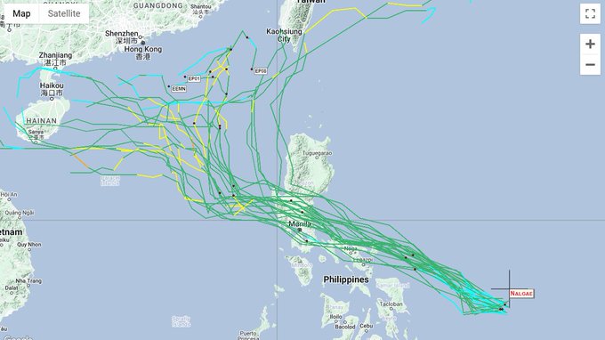
WeatherManila
@Weather_Manila
Followers
3,696
Following
838
Media
678
Statuses
1,104
Weather in the Philippines. Ph.D. in atmospheric physics. Prof. of Meteorology - University of the Philippines Diliman.
Philippines
Joined December 2011
Don't wanna be here?
Send us removal request.
Explore trending content on Musk Viewer
#RafahOnFıre
• 1471961 Tweets
Armageddon
• 645965 Tweets
#THEDANCEDAY
• 134853 Tweets
giselle
• 103416 Tweets
İsrail
• 91447 Tweets
#CDTVライブライブ
• 90564 Tweets
SAKAMOTO DAYS
• 63174 Tweets
Fermín
• 53580 Tweets
Pablo Iglesias
• 51490 Tweets
아마겟돈
• 50428 Tweets
#MemorialDay
• 44905 Tweets
Irene Montero
• 42664 Tweets
D.U.N.K
• 40142 Tweets
الجيش المصري
• 38125 Tweets
Maresca
• 34033 Tweets
世界さん
• 30723 Tweets
Leicester
• 19813 Tweets
ケイくん
• 19043 Tweets
蘭ちゃん
• 16905 Tweets
Jarabe
• 16299 Tweets
ハーフタイムショー
• 15808 Tweets
ダンスデイ
• 15005 Tweets
サカモトデイズアニメ化
• 14922 Tweets
Kabir is God
• 13958 Tweets
#مرزوقه_والمشاهير_بدر_المطيري
• 13298 Tweets
音楽の日
• 11070 Tweets
Ferran
• 10936 Tweets
Eurocopa
• 10425 Tweets
Last Seen Profiles


Pinned Tweet

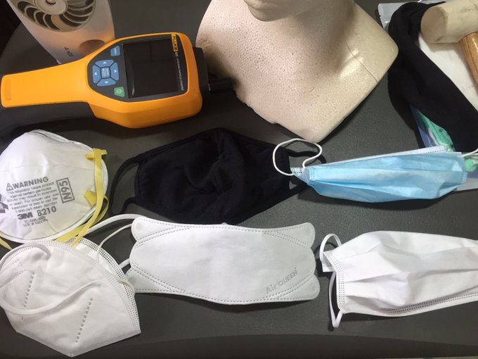
I've been testing the masks that we wear, especially important now with the delta is known to infect through "fleeting contact". This is just prelim data and I'm still collecting data, but thought would be useful to share. Definitely, not all masks are made the same ...1/4
7
219
689
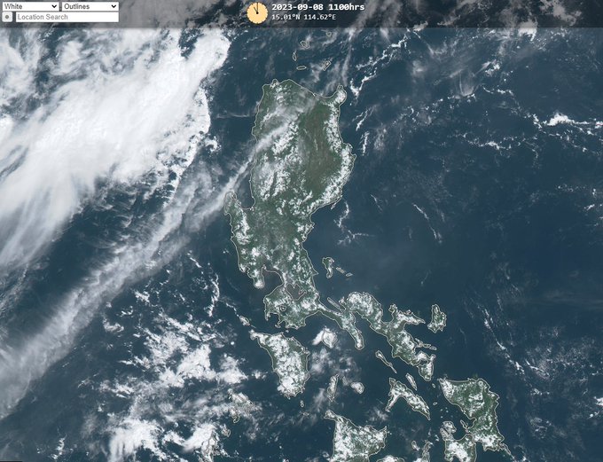
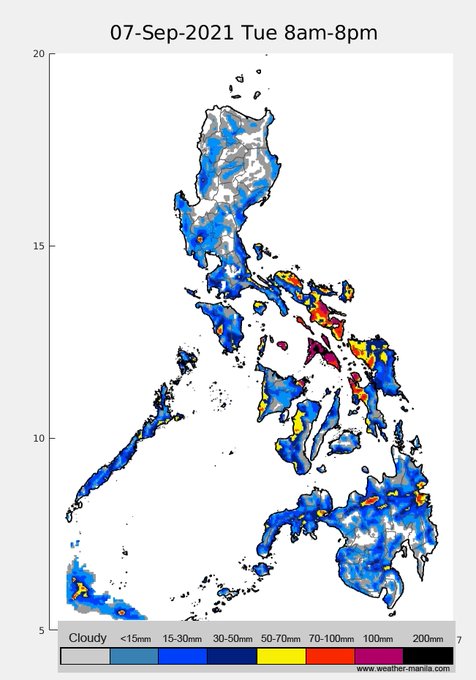
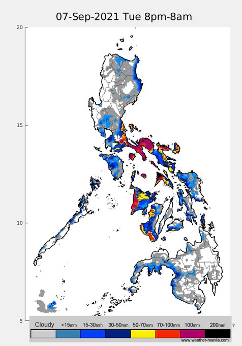
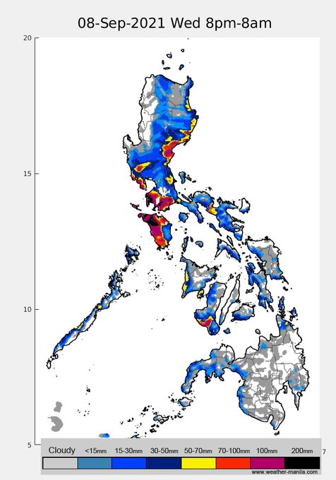
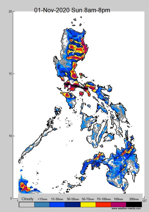
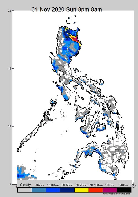
Why is it hazy today in Metro Manila? No, it's not from Taal
1) prevailing wind is easterly, wind also comes from Manila Bay called sea breeze, it's blowing eastward. When they "collide", air becomes stagnant. Wind speed is quite low over Metro Manila
6
210
338
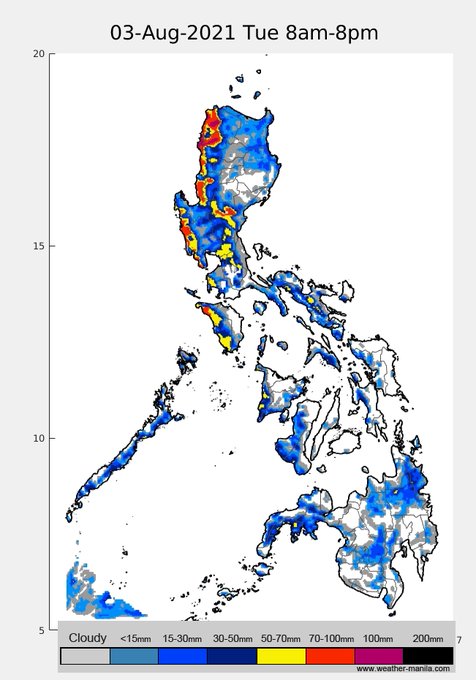
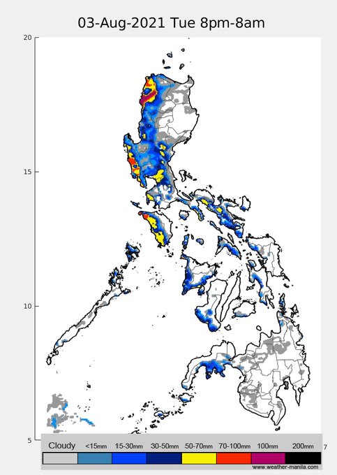
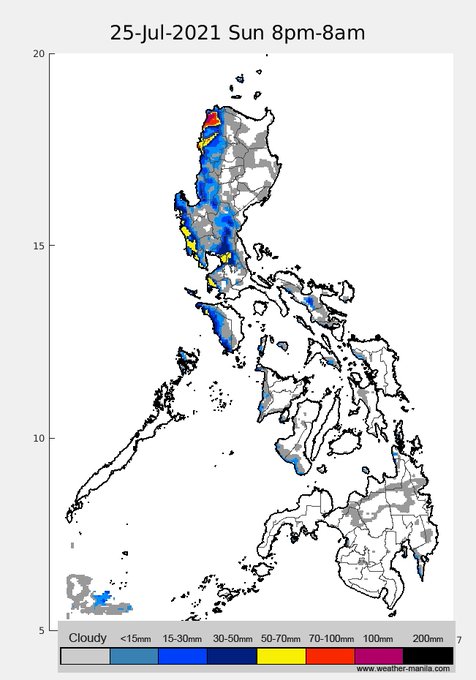
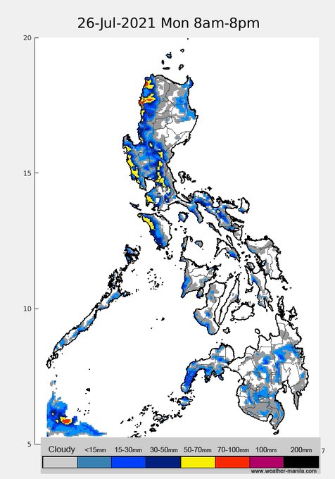
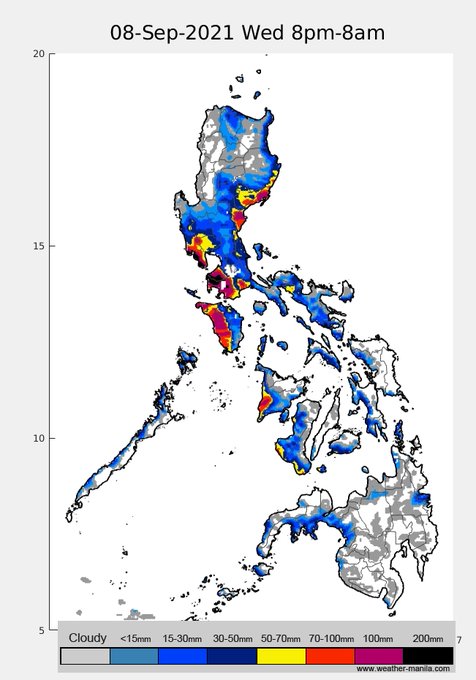
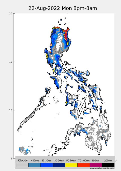
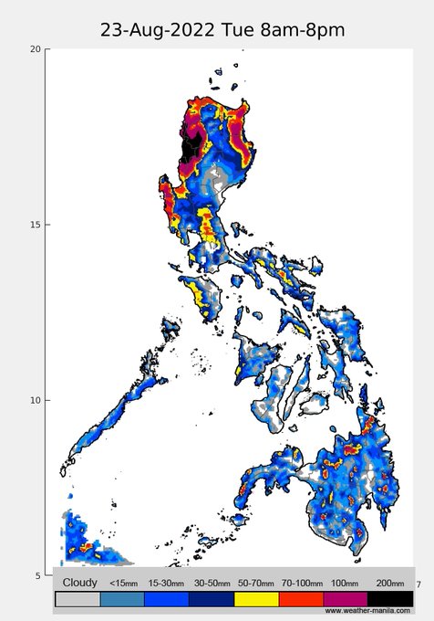
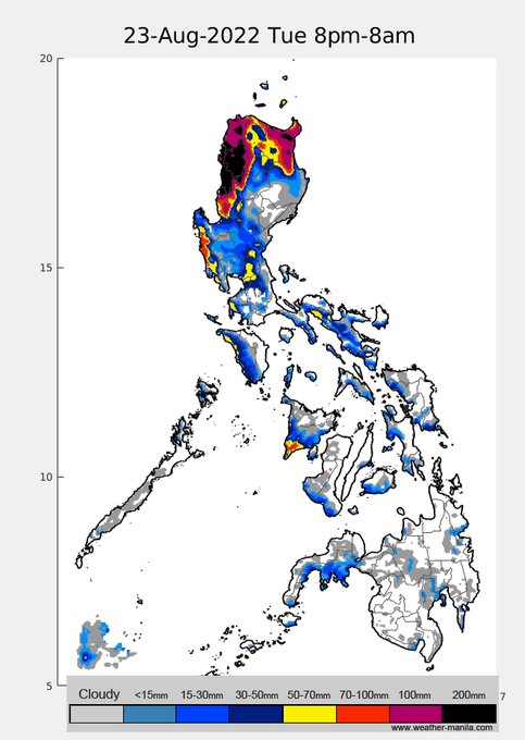
the 2 lows near Hong Kong and east of Taiwan may intensify a bit tomorrow, deepen the monsoon trough and bring rains in northwestern Luzon. Stay safe!
7
47
329
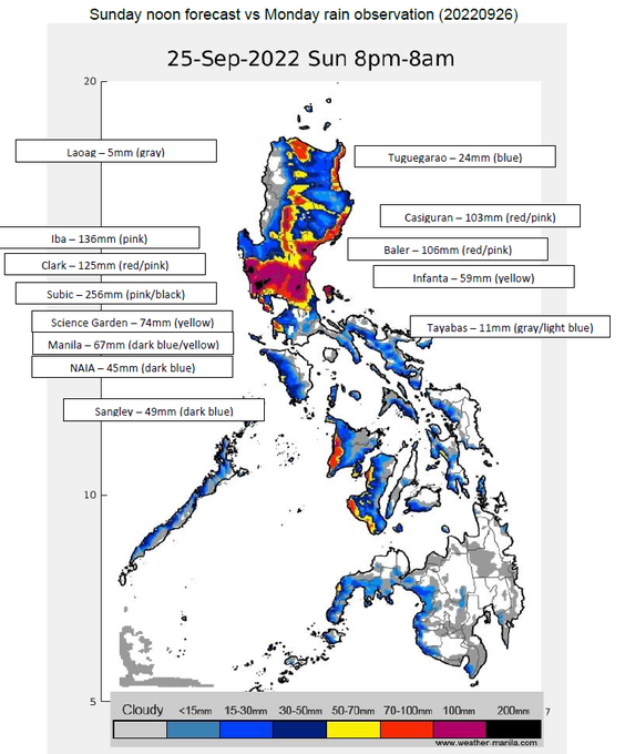
TY
#KardingPH
rapidly intensified and still intensifying b4 landfall later. Most fx on NCR/Cent./NE coastal Luzon.
The upstream of the Marikina-Pasig river basin is projected to receive significant rains, which will result in massive flooding in NCR later today/early tomorrow.
3
164
262
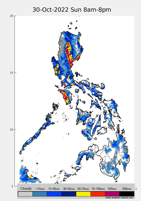
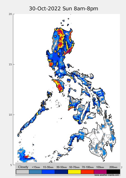
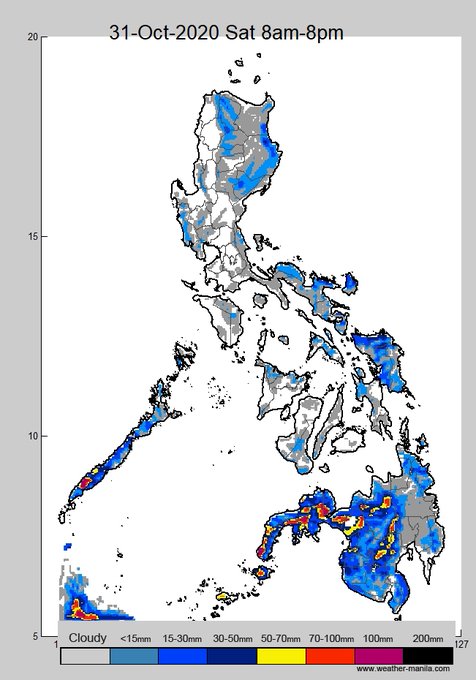
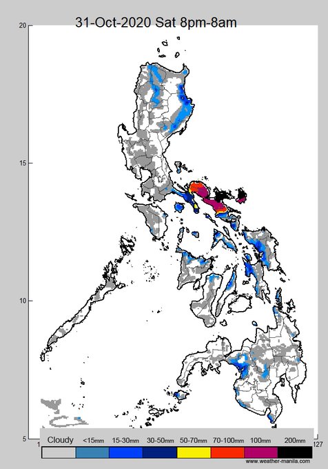
expect a lot of rain from TS
#PaengPH
, probably a typhoon by later today. Catanduanes/Bicol starting later tonight, its trough will affect Visayas today.
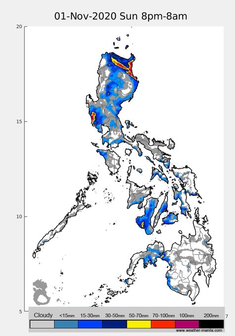
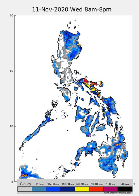
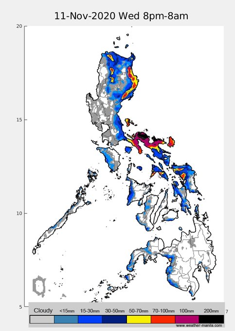
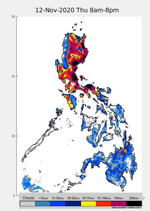
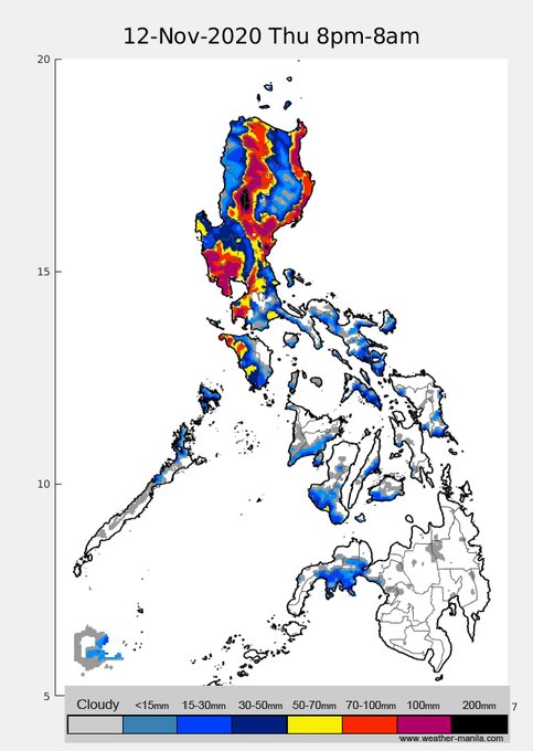
Sat, almost whole of Luz w/ parts upstream of Marikina over 300-400mm. Widespread flooding will certainly occur. Stay safe!
6
166
267
looks like the summit of southern Cordillera mountain is trying to open up the clouds and sneak a peek
0
40
252
rain projection for this weekend (Sat-Sun). Not much rain yet frm
#Mawar
as conditions are not exactly set for enhanced Habagat & also not close enough to bring direct rains. As TY gets closer by Mon-Wed next week, its circulation will likely bring rains to NE Luzon and W Visayas
2
77
211
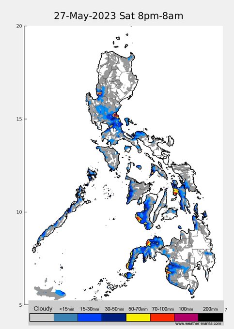
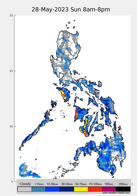
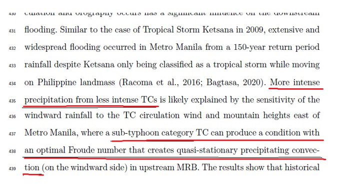
With a similar track as Ondoy, why was Karding less rainy in NCR? the working hypothesis is ironic and counter-intuitive -> Karding had less rain b/c it was more intense
(MRB=Marikina river basin, manuscript <below> still under review though) ...1/4
2
46
152
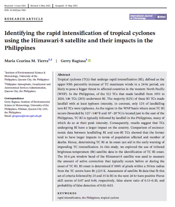
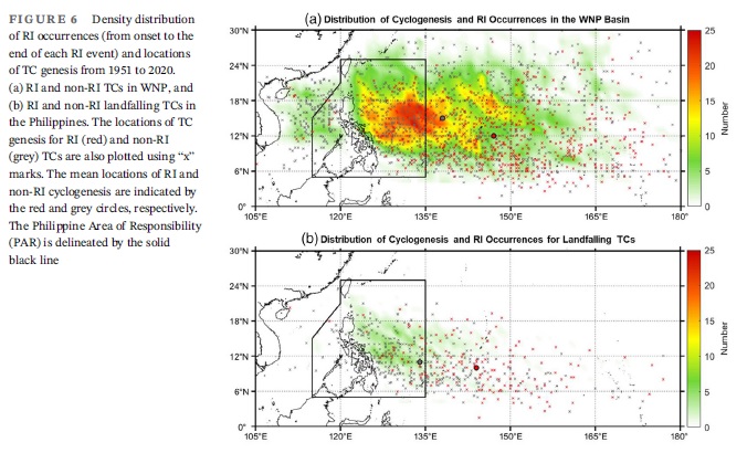
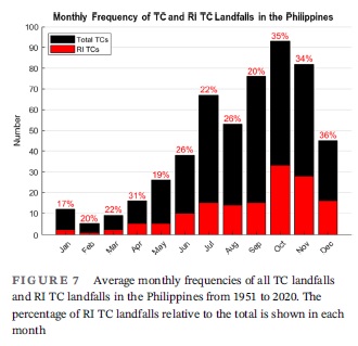
RI means Rapid Intensification (not rocketing inten..). 28% of all TCs that made landfall in the country the last 70 years underwent RI.
RI typically occurs just to the east of PH, so once a TC undergoes RI, there's no time to weaken, and it makes landfall at peak intensity....
4
78
152
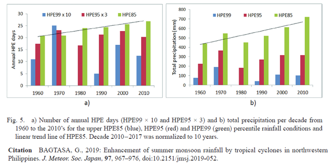
the etymology of "Siyam-siyam" is 9 days of continuous rain. In the 1960's, we had ~18days/yr of heavy prec. events (HPE; >85percentile) like this, in the 2010's HPE's up to ~27days/yr partly because of climate change, should we then change "siyam-siyam" to "siyam-siyam-siyam"?
4
53
141
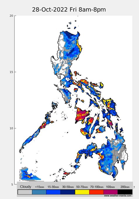
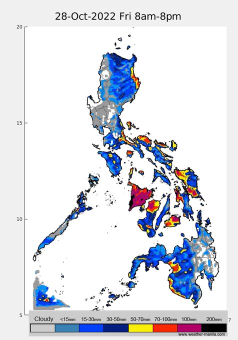
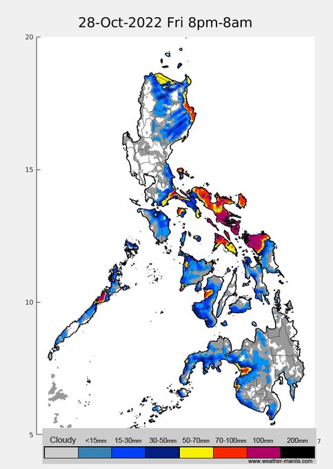
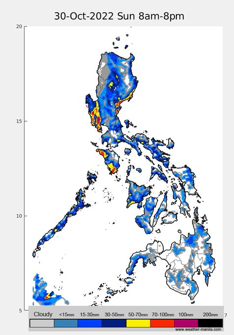
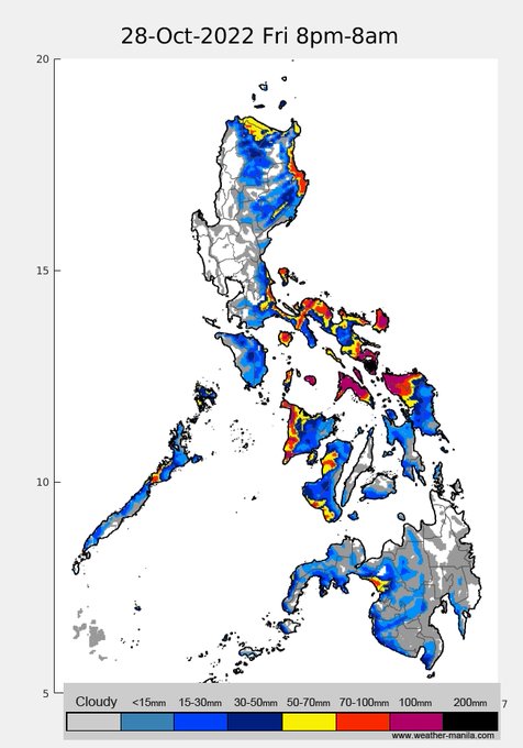
20221028pm update: the southward shift in the track forecast now shows a Bicol landfall, w/c will limit TS
#PaengPH
to further intensify. Consequently, some shifts in rainfall dist. with a closer pass to NCR tomorrow (Sat). Rains and gusty winds will be most felt in NCR Sat.night

1
65
140
rainfall projection for tomorrow (Sunday). The southerly shift in the forecast track of
#KardingPH
has also shifted rains toward Central and southwestern Luzon, including NCR. Note though that the timing may be a bit off (late) - it currently shows late pm to night rain
2
57
146
me: refrain from writing long and winding sentences
also me: writes long and winding sentences
1
10
110
ambient aerosols have bi-modal log-normal size distribution.Comparison of ambient and mask shows varying drops in aerosol #. 1 takeaway here is cloth masks are practically useless for fine particles, it's just for talsik na lumalaway. Mask+face shield shows most drop, .... 2/4
6
23
102
mask w/o FS is almost the same (p=0.08 difference) as w/ FS, and FS w/o mask (as expected, and is a pet peeve) is useless. Data are ave. from both indoor and outdoor expts. Having a gap beside the nose bridge also makes masks almost useless, more so w/ nose out (obviously). ..3/4
2
18
96
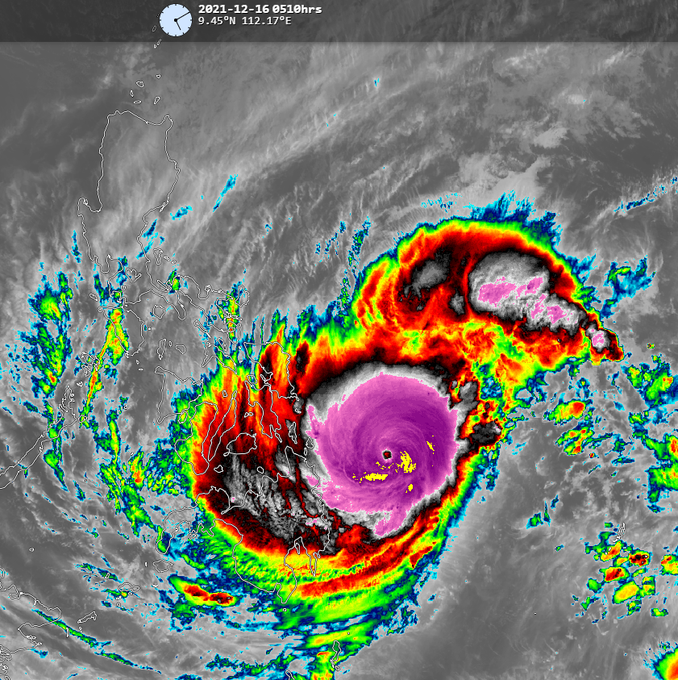
upgraded to Typhoon category since last night! TY
#RollyPH
(Goni) is projected to make landfall around Quezon and traverse just north of Metro Manila at winds of 165kph (216kph gusts; at landfall) on Sunday night, that's pretty intense!
3
60
94
My academic offsprings - 1 PhD in environmental science and 3 PhDs in meteorology
@klimarunong
@iamernestpm
@bumaBAgyo

0
5
100
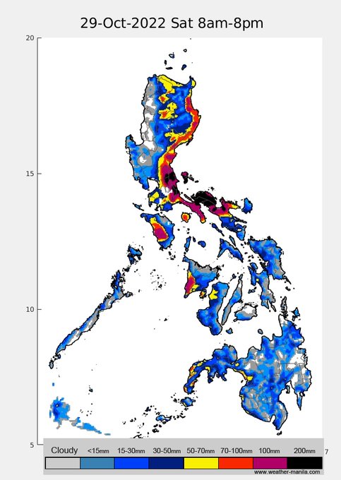
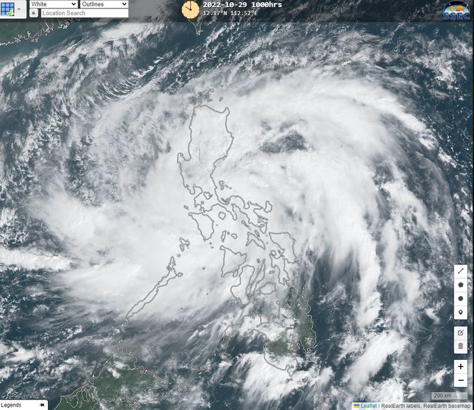
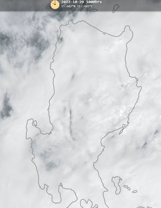
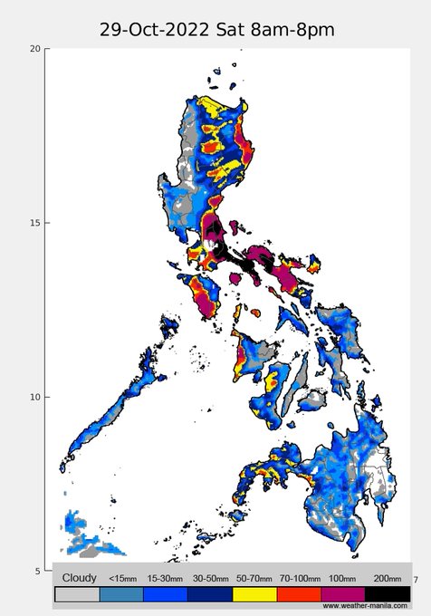
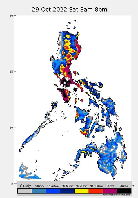
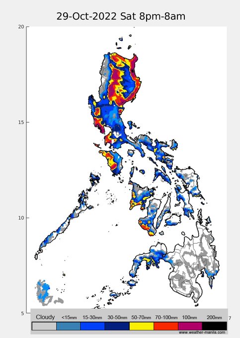
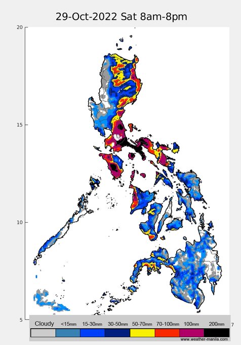
20221029am: Now a Severe Tropical Storm,
#PaengPH
forecast track again slightly shifted overnight, this also shifted the projected intense rains towards the south of NCR as of the latest model run. Rain maps for today and tomorrow. Stay safe!
1
68
89
1/4L of air was evacuated before each measurement to remove air in the gap of the manikin. BTW, we call her Valterri ... Valterri Butas. Masks are NOT perfect filters, especially for fine particles, avoid gaps in nose bridge, cheeks, and chin. Stay safe! ...4/4

6
8
79
rain projection for weekend, significant rains along the western coastal parts of PH due to Mawar-enhanced monsoon likely to start around Sunday pm, these rains may persist until Friday next week. Mawar will likely graze NE Luzon, rains and winds in that area as well. Keep safe!
1
45
86
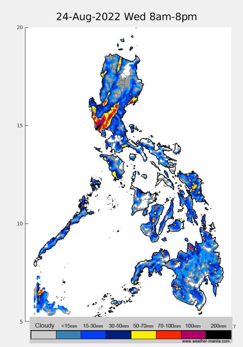
emissions from Taal have been partly causing the high pollutant episode since Monday (28Jun). Mon. am haze was exacerbated by a strong inversion and weak winds, but nonetheless, Taal emission continues to persist until today (Wed)
From the model, (Mon) Taal plume veers to ...1/4
4
55
87
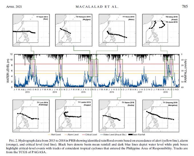
our study () shows since 2013, if a typhoon directly traverses the Pampanga river basin (PRB), there will be flooding (Arayat water level breaches critical level) regardless of antecedent rain. Expect flooding in the downstream of PRB due to
#KardingPH

0
40
86
our study () on what causes NCR high pollution events typically stems from weak monsoon flow and opposing mesoscale winds, not from thermal inversion (in most cases). I reckon pollutants from Central Luzon + NCR emission + stagnant air is causing this haze

1
28
81
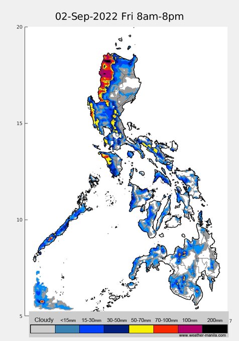
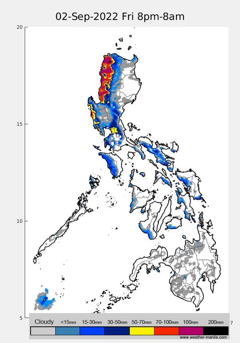
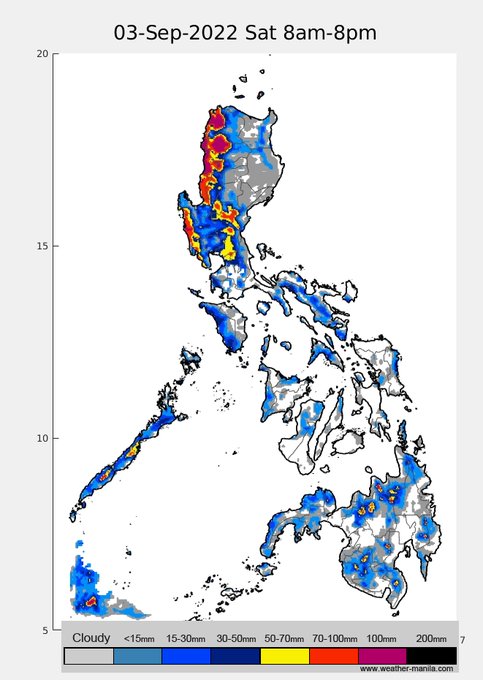
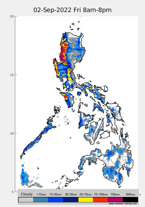
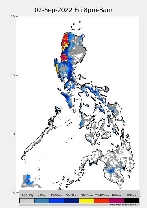
we'll likely have a rainy weekend along western Luzon starting Friday as Super Typhoon
#Hinnamnor
enhances the monsoon. Its closest distance to landmass will be on Friday morning at ~450 km away, so no direct effect is expected (except for strong/gusty winds in Batanes).
3
33
75
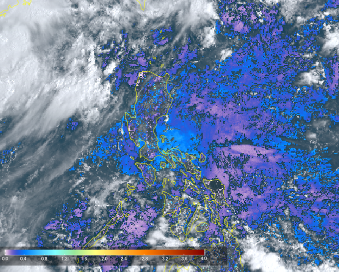
aerosol optical depth from Himawari-8 from 9 am shows apparent high values of ~0.8 (light blue) around southern and SE Luzon. This is also seen in the visible image. This is likely caused by stagnant air unable to disperse pollutants in the region
1
31
70
My only problem with N95 is that I learned may bilbil pala ako sa pisngi
2
7
63
TY
#OdettePH
intensified to max winds of 150kph this morning, and the extremely cold overshooting cloud tops (yellow) suggests even further intensification in the next 8 hours before it makes landfall in the Caraga region.
0
22
59
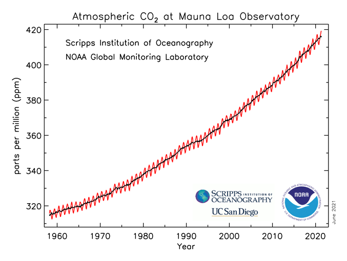
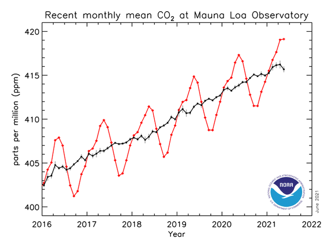
Carbon dioxide is at a record high of 419 parts per million! after all the talks, not even a dent.
1
20
61
rains will be mostly nighttime, RI resulted in late warnings, and it's the weekend. Not a good combination in extreme events like this.
Expect gusty/strong winds in NCR to peak by tonight/early hrs of tomorrow. Gradual gustiness by afternoon later. Some rains still expected Mon
0
45
58
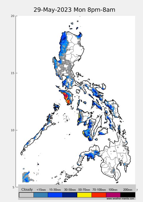
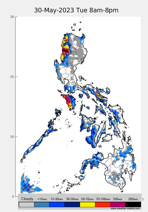
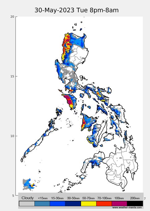
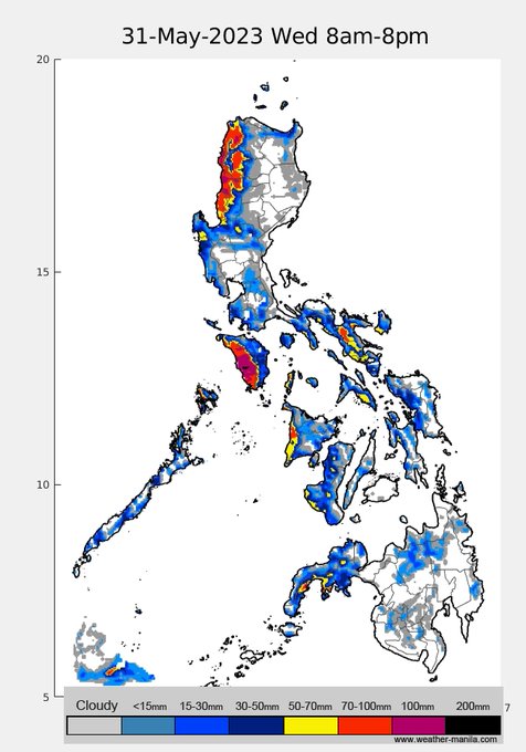
Mawar is now officially
#BettyPH
, w/ winds of 195kph, it is ever so slightly de-intensifying as it moves over cooler waters and some dry air to its NW, though it will still stay as an intense system in the next 5 days. Rain projections in the next 4 days, pm thunderstorms today
1
26
60
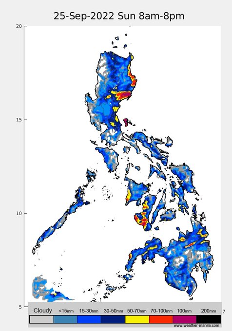
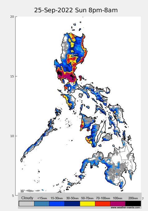
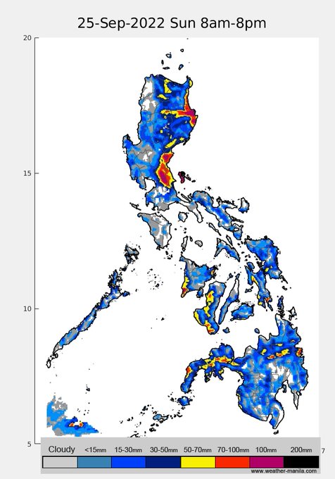
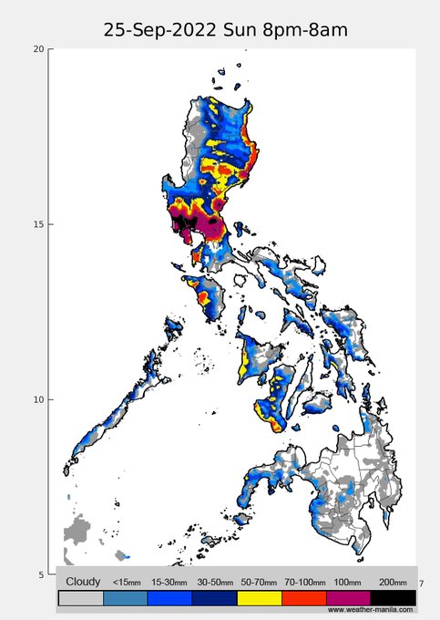
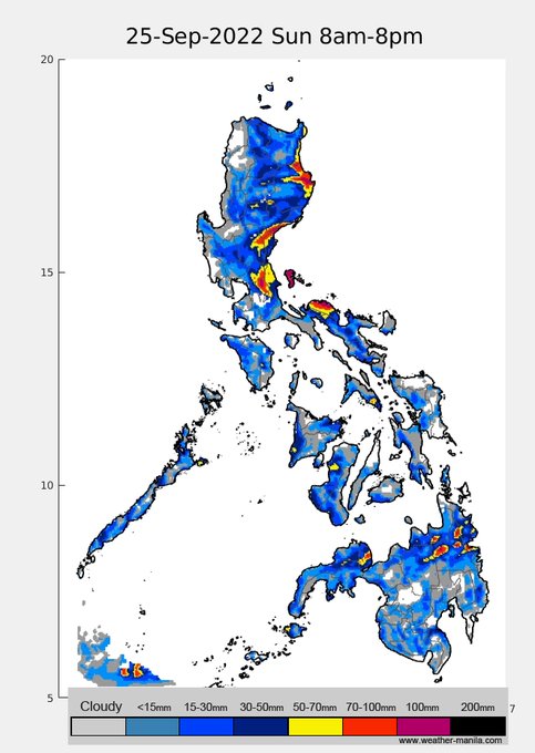
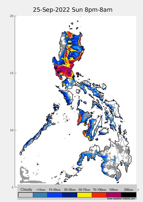
20220925pm rain projections for STY
#KardingPH
, a little northward adjustment compared to the previous run, but more or less consistent rain distribution and intensity for the past 4 model runs
1
26
57
very wet rainfall projection for
#UlyssesPH
on Wed for SE Luzon/Bicol region and Thu for rest of Luzon. Currently only a tropical depression, favorable environment will enable it to intensify to possibly typhoon category at landfall. Still many uncertainties in track and timing.
1
32
51
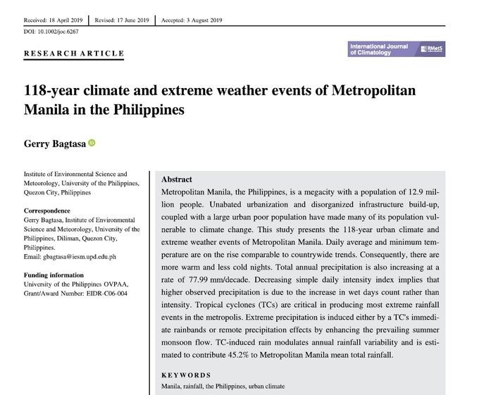
good evening! NCR is no stranger to typhoons, in fact, 45% of our water is cyclone induced. My paper on this -
2
17
56
Today (4Jul) Taal plume was transported southward, then swirled along with the LPA's circulation in Tayabas Bay. Tomorrow (5Jul), the plume will be transported northward traversing NCR. This model doesn't include
interaction w/ rain, w/c generally cleans the atmosphere.
4
39
58
quick forecast assessment, (modesty aside...) medyo awesome yun rain forecast
2
9
55
the end of this rain is not yet in sight. though we may see some sunshine tomorrow or Tue, looks like rains along western Luzon to continue possibly until Wed. Here's the rain projection for the next 4 days

1
23
55
Rains for the next 3 days from TS
#AgatonPH
mostly in Visayas, particularly Leyte (>400mm projected in certain places), Samar, Cebu, and Bohol. Stay safe!
2
29
52
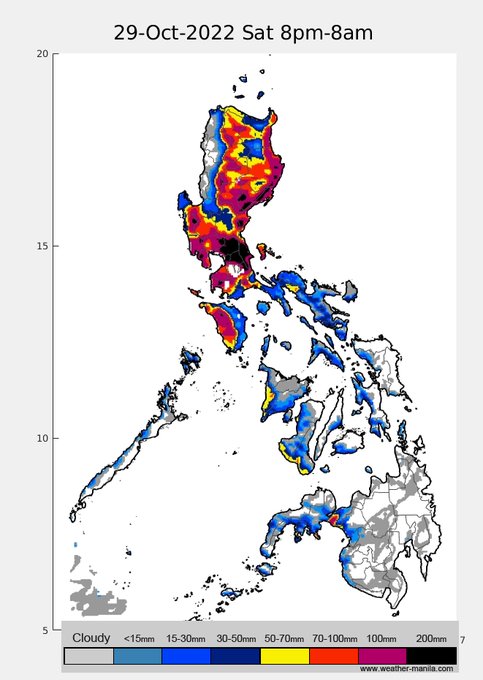
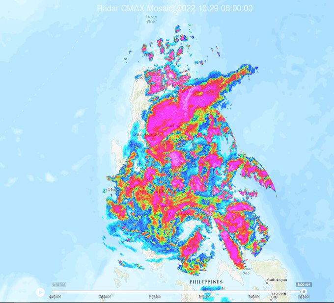
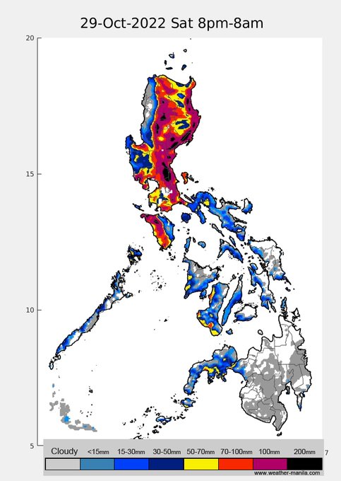
(20221029 20PST) rains from
#PaengPH
to continue tonight til early tomorrow, particularly in Reg. 2 and SW Luzon & Mindoro, then mostly SW Luz tomorrow. Stay safe and dry!

0
29
54
Projected rain in the next 4 days. TD Ambo,~400km off east Mindanao, will likely persist as a TD til Wed
In the nxt 3 days, we'll see active (daytime) thunderstorms across Mindanao and rest of country. Rain from Ambo will likely be felt from Thu/Fri along east Vis and reg 5
0
17
50
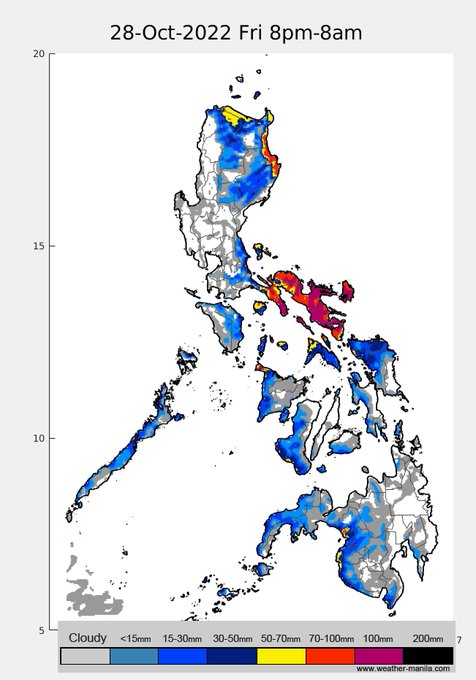
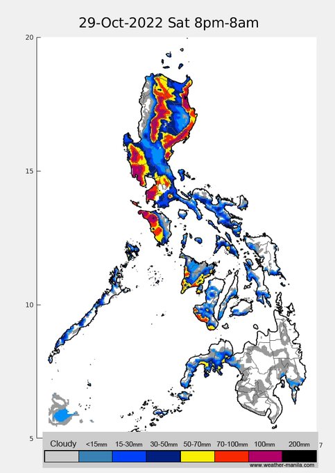
20221028 19pst update: rain projection in the next 48hrs - TS
#PaengPH
. A little more southward shift in the track forecasts, but more or less still the same rain amount and distribution. Stay safe!
1
31
50
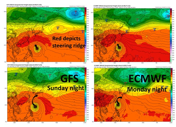
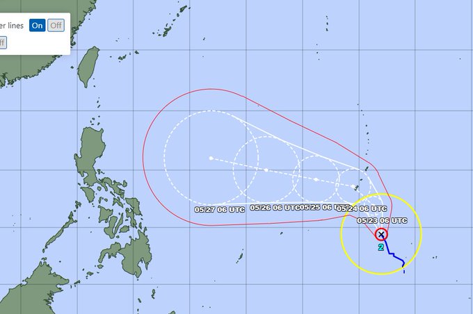
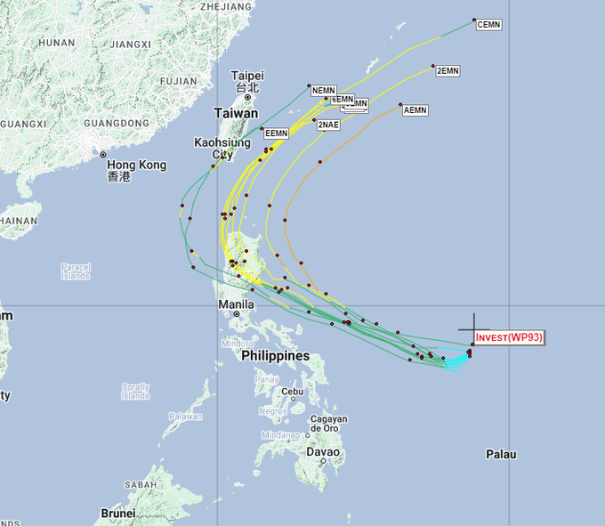
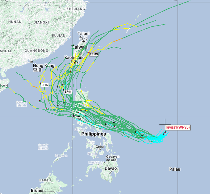
#Mawar
track forecasts have been consistent & in good consensus,will enter PAR by Fri pm. The ridge to its north (depicted by red) will initially prevent its northward movement but is projected to weaken by Sun pm for GFS and Mon pm for ECMWF, once it does, Mawar will recurve 1/2
3
19
52
I believe still a fair bit of uncertainty in track forecasts of TD
#PaengPH
. Forecasts from PAGASA or JMA leaning towards the mean of NCEP(L) ensemble or north end of ECMWF's (R). Though it looks more like landfall in N.Luz. Expect further track changes in the coming updates.
1
20
49
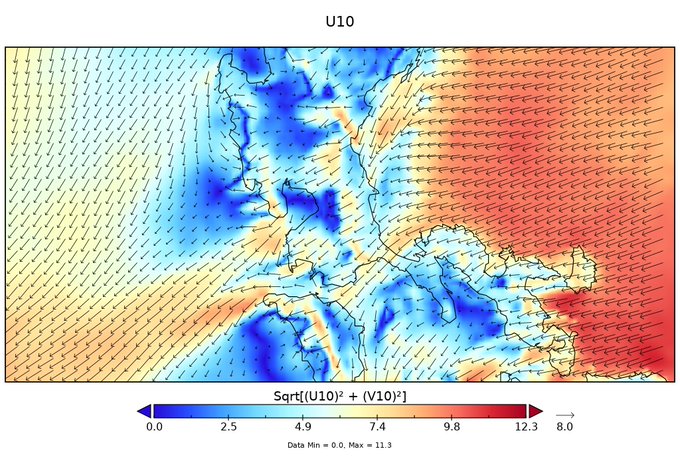
Yay, another paper for the year (still in press). So, does the Sierra Madre Mountain range make passing typhoons less intense? The short answer is NO
@bumaBAgyo
pinitik ko tong image mo ah

1
9
50
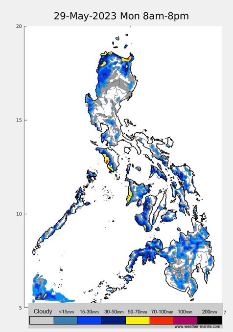
rain projections in the next 4 days, afternoon/evening thunderstorms in the next couple of days, then by Sunday pm, a stronger monsoon will affect Visayas, then Luzon, w/c may persist the whole week next week
1
36
50
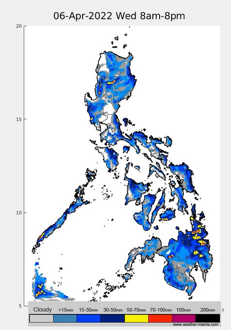
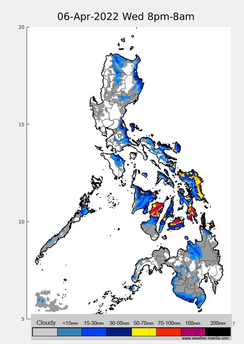
the LPA east of Mindanao will persist in the next couple of days resulting in significant rainfall across Visayas and Mindanao (20220406)
1
19
46
Explaining to this admin why we need science-based/informed policies

0
17
46
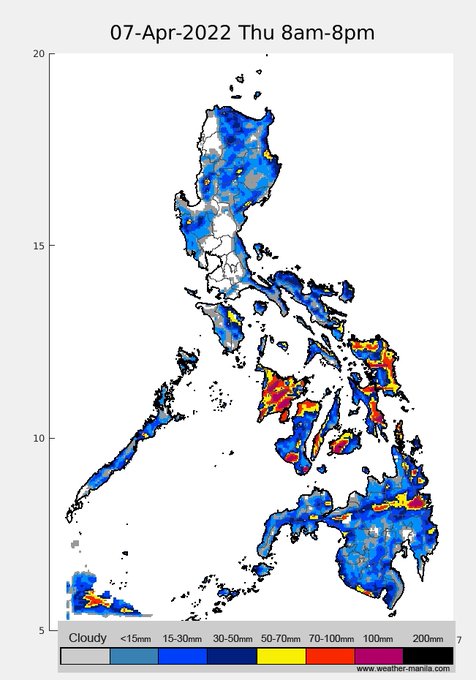
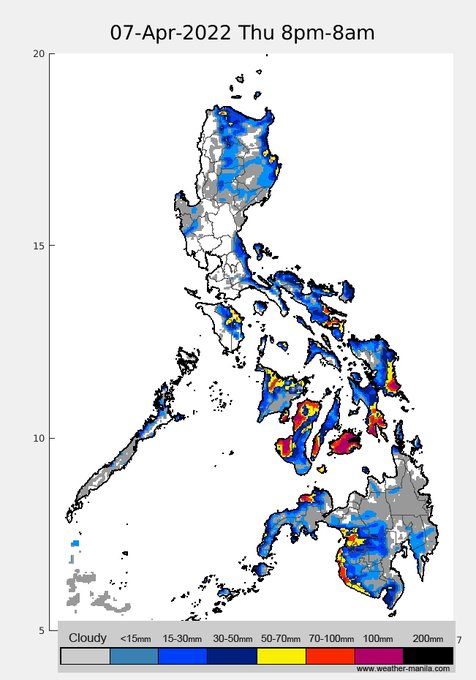
the LPA in Mindanao will interact with the prevailing easterlies and bring rains across Visayas and Mindanao today.
0
7
46
the vice president takes over when the president is incapacitated, sounds about right
0
7
48
rain projection until Friday, significant rains in many places due to a strong monsoon induced by TY
#BettyPH
. Stay safe!
1
23
47
>600km radius! TC size is a function of humidity. Rolly was small and super intense w/ large pressure gradient, but not much rain due to dry conditions then.
#UlyssesPH
carries a lot of moisture, coupled with its slow movement, will bring catastrophic rain along/around its path
2
31
45
3) is that fog? NO, high humidity (there's drizzle) results in particulates being coated with water, which further reduces visibility. This gives the appearance of fog. This property of particulates called hygroscopicity is one of the topics of my dissertation/2007 paper

1
13
43
this article is so ridiculous, the typhoon and the stationary front are two, totally different things, and have nothing to do with one another. "Generating" pa talaga! It's like saying my car generates a long cemented block that stretches from Monumento to MOA.
0
14
45
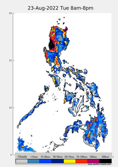
72h rain projection. TD
#FloritaPH
is expected to make landfall in NE Luzon tom. pm and will bring significant rain across N.Luzon regions tomorrow.
In some areas (NW Luzon) with >300mm rain projection, flooding and landslides will (very) likely occur. Stay safe!
1
27
45
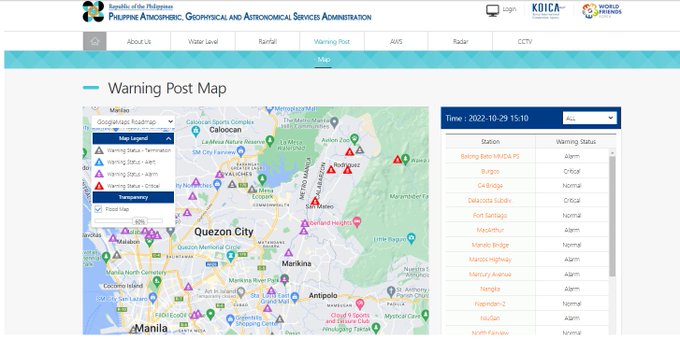
several stations upstream of Marikina river with "critical" warning, almost all stations in NCR in alarm level
2
24
44
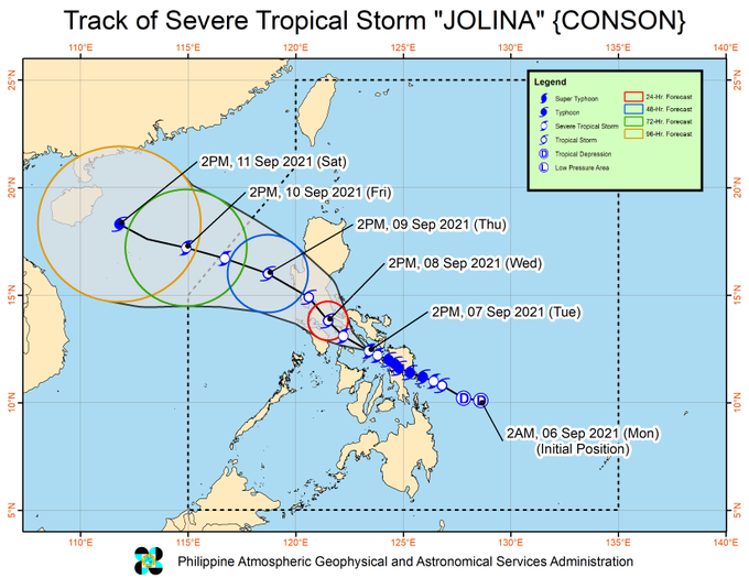
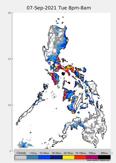
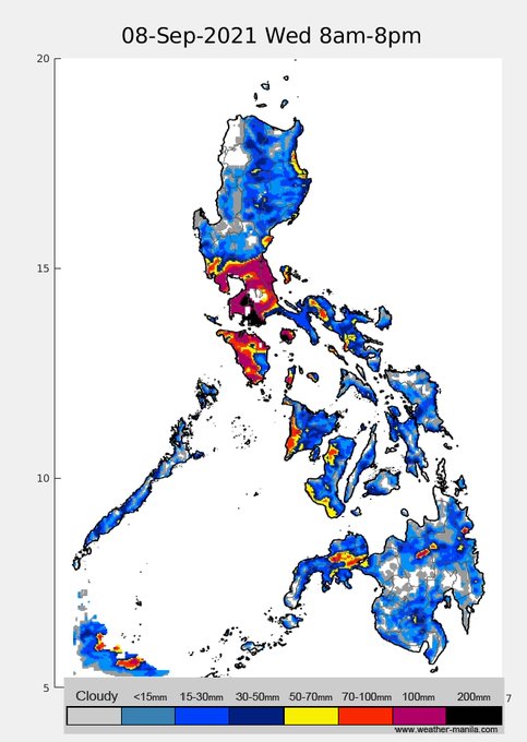
a shift in the projected track of
#JolinaPH
resulted in a slightly different rain distribution in this morning's model update. Rains in Masbate and parts of Bicol today until tomorrow, then southern Luzon with NCR and parts of Central Luzon tomorrow. Stay safe!

0
25
43
TD
#AgatonPH
will still bring significant rainfall over Leyte and Samar today. With the antecedent flooding in the past few days, even more flooding is expected.
Also, possible afternoon thunderstorms in western Luzon incl. NCR

1
32
38
took a while to write this due to the sheer amount of data, but it's finally published. Here, we explain how the high pollution events in NCR are driven by complex opposing winds and the boundary layer (w/
@MObservatory
).
1
13
45
The hazard of
#UlyssesPH
is that it has slow lateral or movement speed, thus, will stay long over/near land and bring significant rainfall in Luzon. Watch out for flooding in low-lying areas, there's still time to prepare, stay safe!
1
15
40
Will those motorcycle barriers work? from this simple CFD simulation, a simple barrier apparently does deflect particulates coming from the mouth of the driver to the face of the back-rider.
this is in contrast to some speculation that a vacuum forms behind the barrier
1
20
39
as per latest track of
#JolinaPH
from PAGASA, it will directly hit Metro Manila tomorrow (track may still change though). Rain projection in SE Luz/N Vis later, SW Luzon (incl NCR) tomorrow.
This will further exacerbate our covid problem (w/ 18k on a Tue!) Be safe always!
0
29
44
the "optimum" location of a tropical cyclone for it to enhance the monsoon is if its near an imaginary line connecting Okinawa and N. Luzon. For
#FalconPH
, this will happen around Monday to Wednesday, resulting in heavier projected rainfall
0
23
43
(20230922) since yesterday, weak westerly to the west and easterly to the east were converging around Central/South Luzon (incl NCR). Simulation includes SO2 from Taal. NCR/C.Luz emissions have nowhere to go, moved by landbreeze to MNL bay last night then seabreeze this AM (1/5)
1
23
41
TD
#FloritaPH
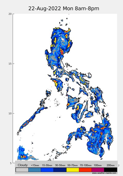
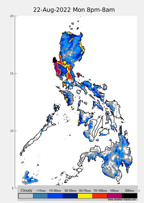
(Aug22 7:30am) has an exposed circulation. Most of its clouds are to its SW as supplied by moisture from the monsoon. It is in a moderate shear of ~20 kts but is still expected to slightly intensify into a tropical storm later today & will stay as such while..(1/2)
1
16
41
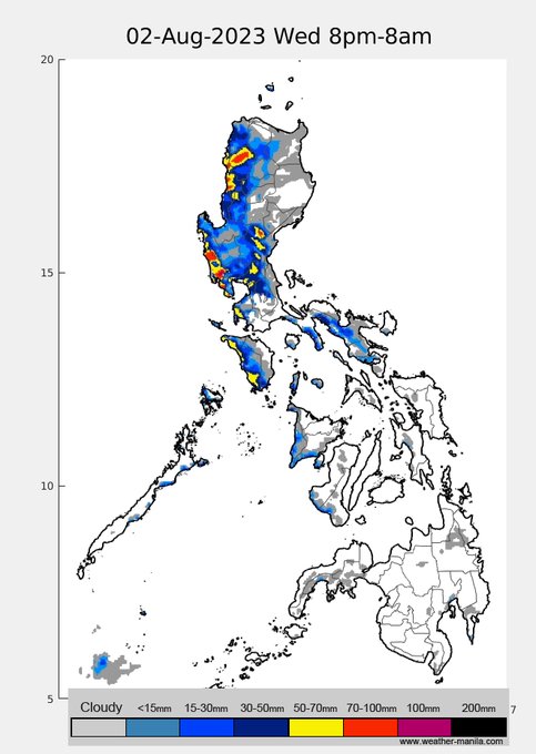
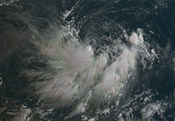
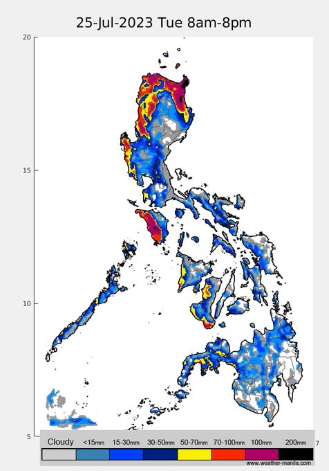
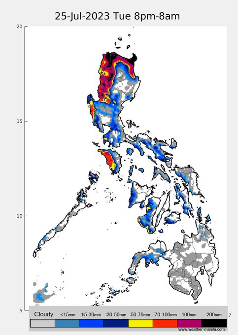
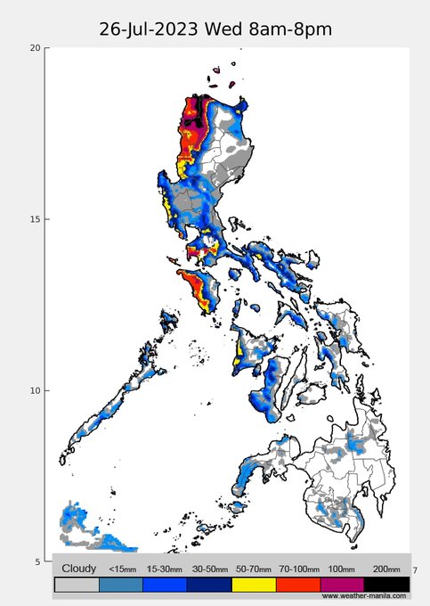
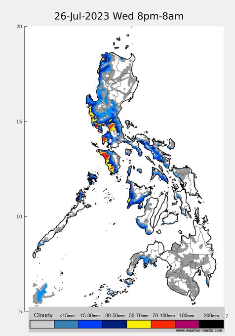
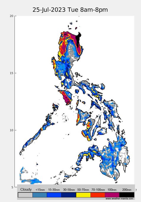
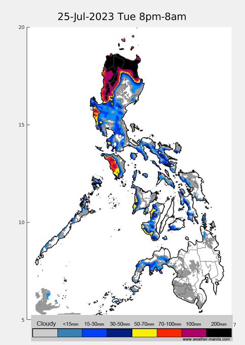
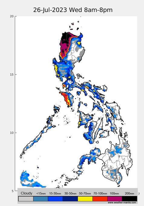
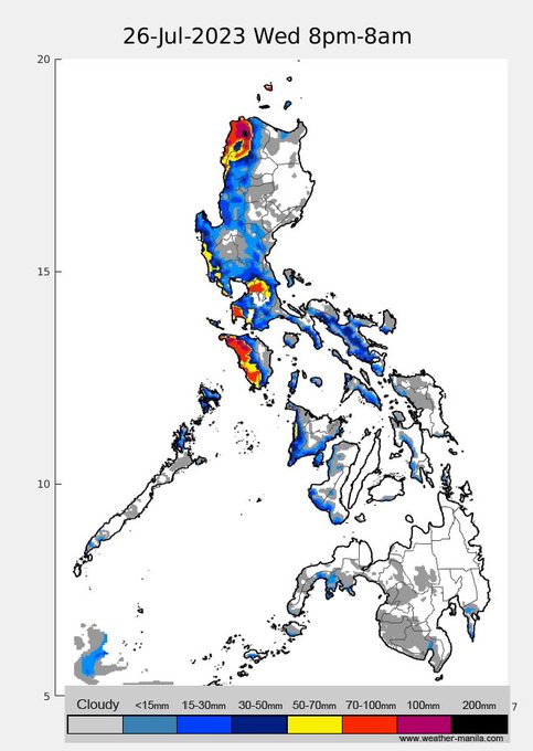
(20230725am) Rain projections due to TY
#EgayPH
and strong monsoon. Significant rains in northern and NW Luzon. Flooding and landslide in those areas are imminent. NCR intermittent rains today, possibly more rain in the coming days
1
19
40
Rain projection in the next 5 days
#BettyPH
. Rains today in North coast of Luzon, especially the NE tip of Cagayan, then Mindoro later tonight. More rains starting tomorrow along the Ilocos region and w Mindoro
2
18
37
looks like no major disturbance for most of June, especially for the southern parts of PH
0
5
38
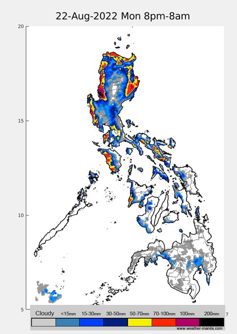
(20220822pm) the more southward shift of TS
#FloritaPH
projected track will limit its intensification and temper its associated rains. Significant rains are still projected starting tonight (til tom.) in NE and west Luzon, but less compared to this morning's update. Stay safe!
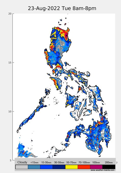
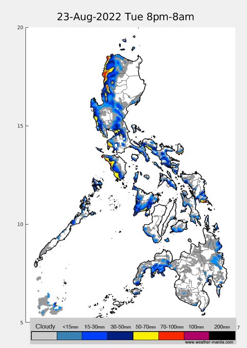
0
14
40
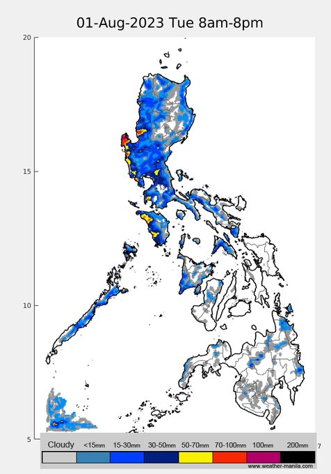
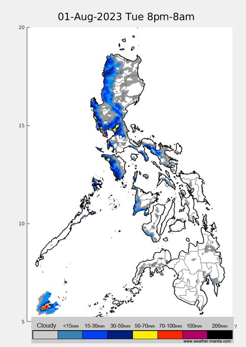
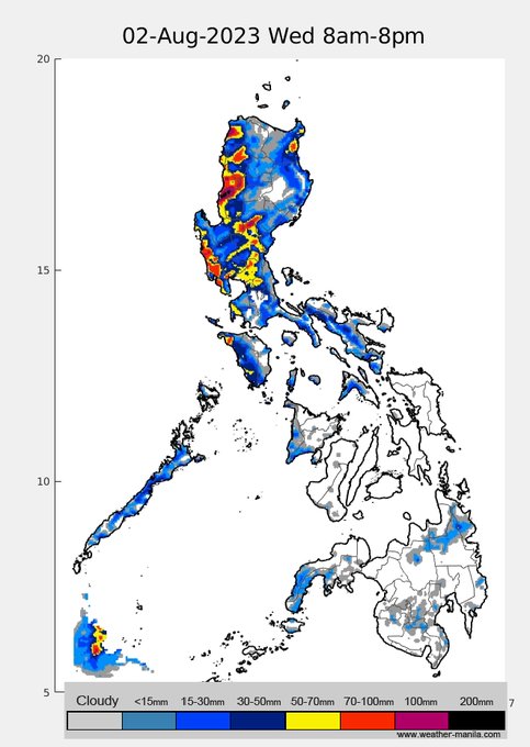
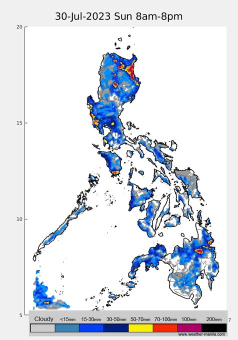
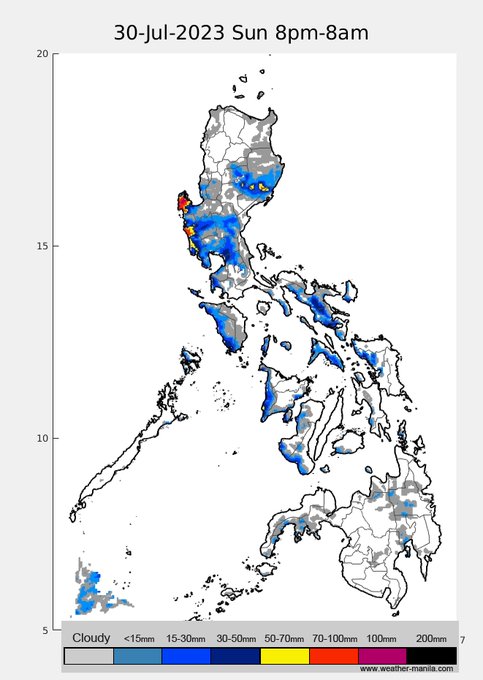
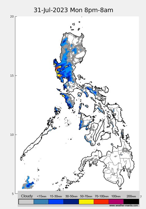
(20230730am) Rain projection in the next 4 days. Enhanced Habagat will persist and affect SW Luzon (incl NCR), expect similar conditions as yesterday/today in the coming week. This is partly due to STS
#FalconPH

1
24
40
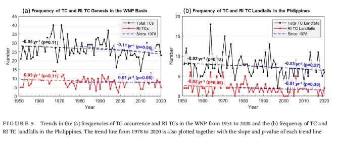
RI can happen in any month but most in Oct., and there seem to be no trends in RI frequency in PH.
RI is still notoriously difficult to predict, its driven by the inner core dynamics which lack observation and are not properly depicted in weather models.
1
17
35
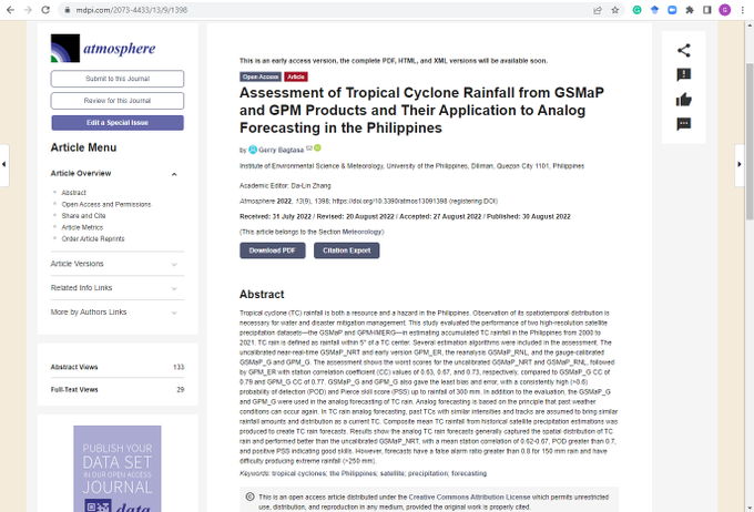
yehey! my new paper on the assessment of satellite-derived TC rainfall and its use in forecasting published
0
4
37
I imagine dumaan ng 3 board meetings ito, sa final vote kung i-discount ba o hindi itong product ay 9-8 in favor of i-discount

2
9
38
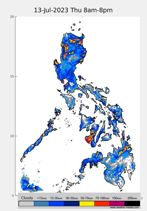
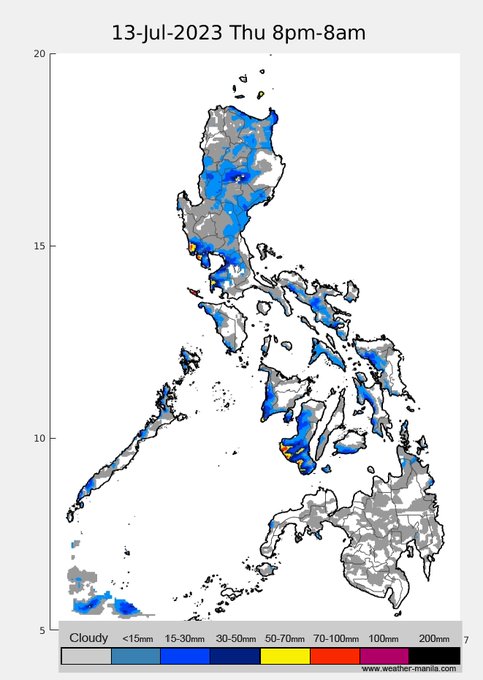
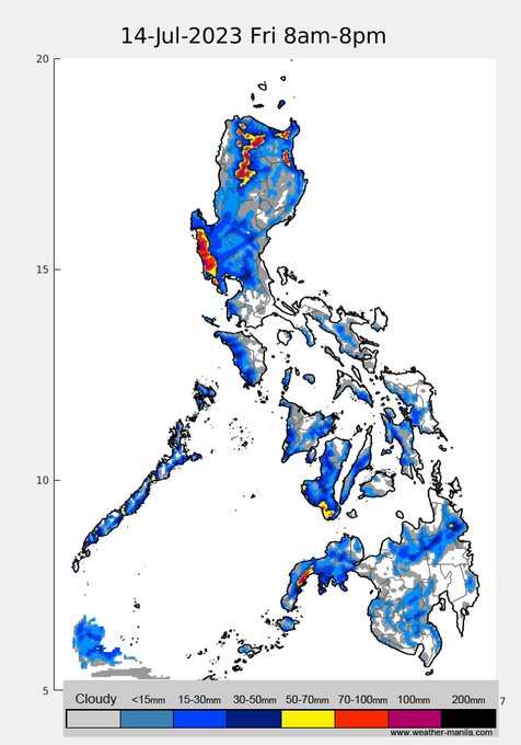
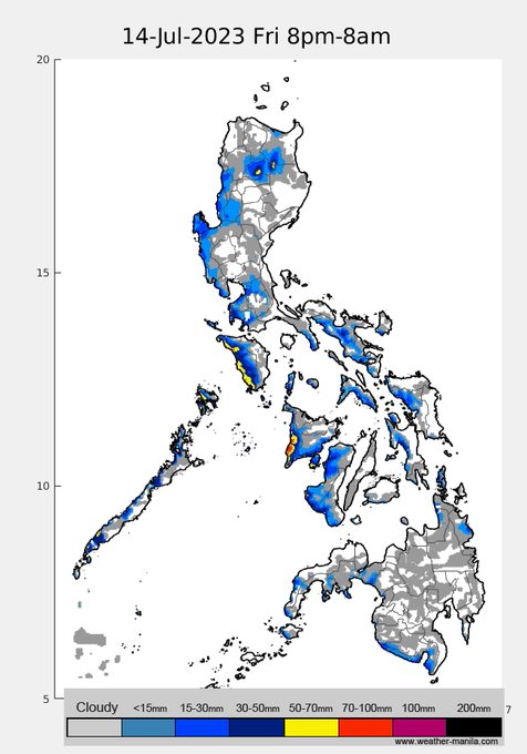
(20230713am) Projected rainfall in the next 3 days. A little rest from the hot weather especially for Luzon and most of the western coasts of Visayas
1
18
36
while we're pretty sure of a Central Luzon landfall of TS
#PaengPH
, after emerging from land, there is still a bifurcation between westward movement (majority of ensemble members) and recurvature to Taiwan (in which case Ilocos will likely be more affected by rain and wind)
0
13
35
Our paper on Typhoon Ulysses (2020) is now published in the Phil. meteorological research special issue of PJS .
Here, we described what made Ulysses so rainy and tested the common belief that it was a manifestation of climate change-it was & also wasn't
0
9
36
Refrain from outdoor activities, stay indoors and keep safe!
1
9
33
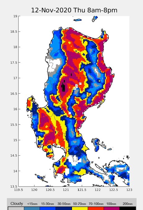
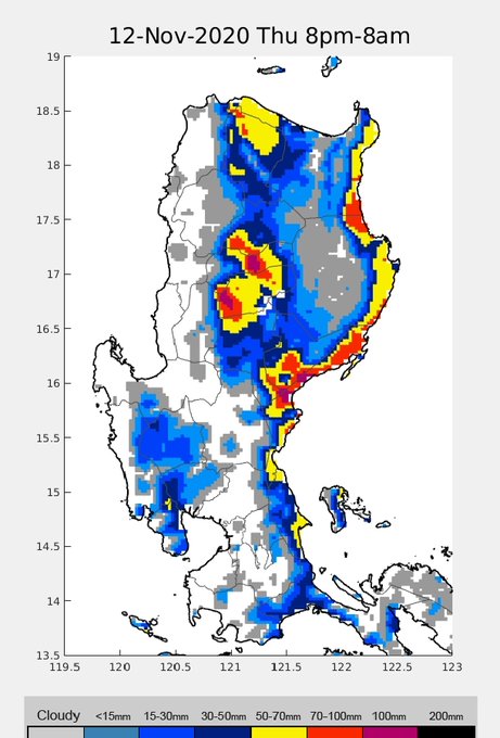
TY
#UlyssesPh
(
#Vamco
) is not done. Rains in central, northern, and eastern coast of Luzon today. Places like parts of Cordillera, Baler, Casiguran, Palanan, rain until tomorrow.
0
24
35
TY
#OdettePH
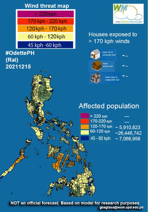
will make landfall around N. Caraga tomorrow afternoon at winds of ~140-150kph. Wind threat map below (Note that 60-120kph area/population is likely overestimated as it includes the effect of monsoon surge in northern PH on Friday)
0
18
32
#UlyssesPH
already a tropical storm w/ still very wet projection for SE.Luz on Wed and rest of Luz (incl.NCR) on Thu. Most track forecasts are more in consensus and look like a direct hit for Metro Manila. Likely a typhoon by the time it passes just north of Catanduanes on Wed pm
1
15
33
did a quick and rough simulation from Sep5-11, because of the weak monsoon, pollutant emissions from N, central, and S Luz were advected northeastward and lingered there, at times moved back inland. The lack of regional ventilation looks to be what caused the high-pollutant event
1
8
34
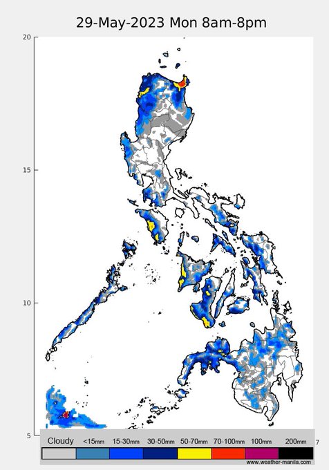
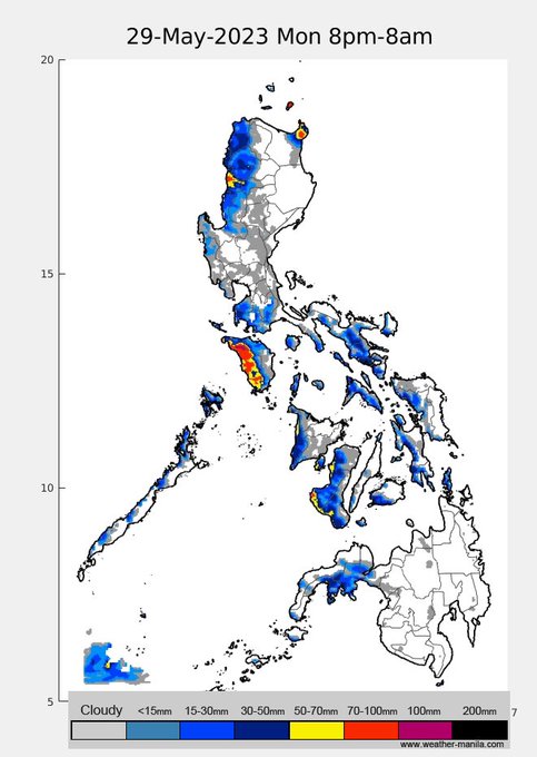
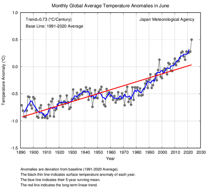
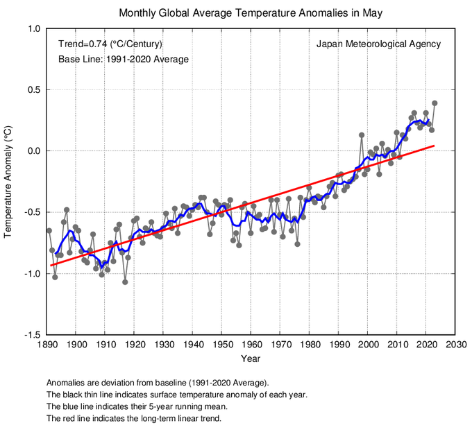
May and June 2023 temperature anomalies, wow!
July likely to be warmest in recorded history as well
1
8
35
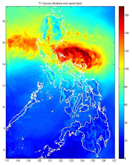
latest modeled surface winds of TY
#UlyssesPH
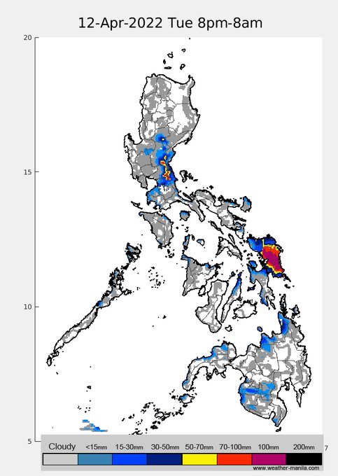
. Note the >100kph winds in parts of Central and southern Luzon, and NCR. NCR will start getting gusty early tonight and peak in the early hours of Thu.
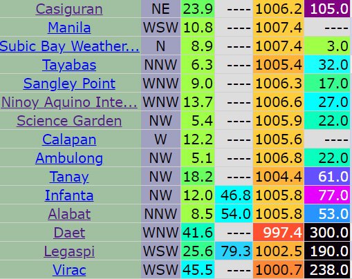
Observed rainfall in Virac and Daet since yesterday already above 100mm!
3
22
32
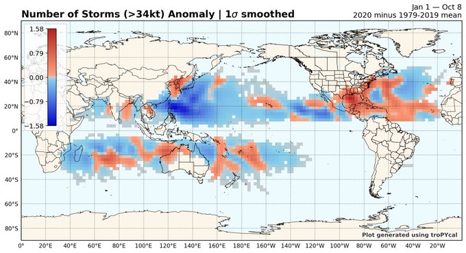
anomalously low TC number for us this year as shown by blue color

Here's the global spatial anomaly of number of tropical cyclones so far this year.
The Atlantic, and specifically the United States coastline, really stands out.
2
19
72
0
16
32
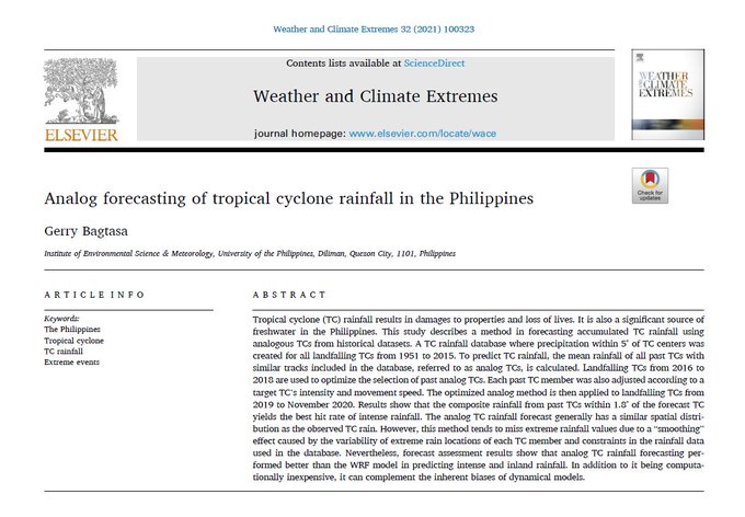
'Those who cannot remember the past are condemned to repeat it.' -- my new paper on forecasting TC rainfall using past historical data is out today
0
7
32
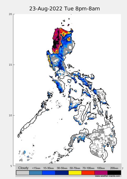
3-day rain projection. TD
#FloritaPH
is expected to move towards N.Luzon. PAGASA predicts landfall in NE Luzon (Cagayan) on Tue pm while others project a bit more northerly track (to Babuyan islands). Significant rains in NE as well as NW Luzon on Tue and Wed. Stay safe!
1
17
31
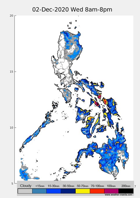
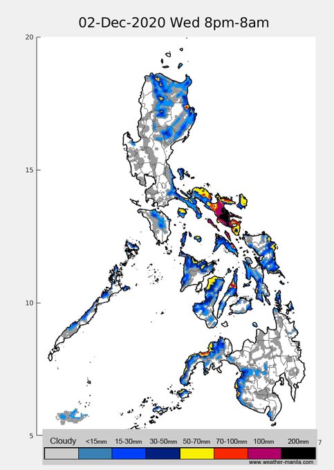
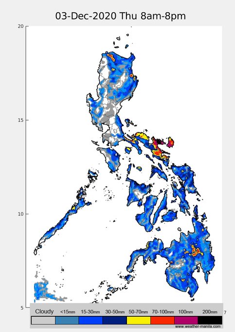
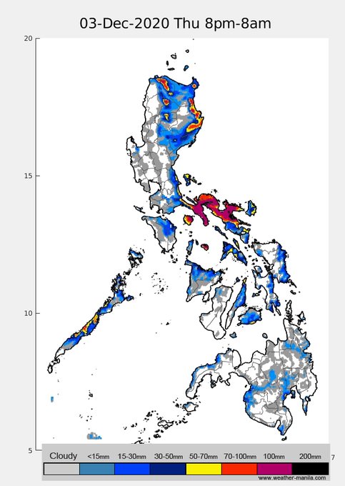
Possibly heavy rainfall in parts of southern Luzon and Bicol region from Dec 2 (Wed) night to Dec4 (Fri) due to interacting/converging LPA and monsoon winds. For now, this rain projection has low-moderate confidence (meaning it can still drastically change).
0
15
29
rainfall projection in the next 72 hours. Interaction of STY
#HenryPH
's trough and monsoon will start to bring rains later tonight/early tomorrow along western Luzon. Monsoon flow will gradually enhance in the coming days so rains will persist until Sunday.

1
16
32
rain projection for the next 48hrs. models and track forecasts of TY
#RollyPH
shifting southerly. Expect rainfall in southeast Luzon later tonight-early hours tomorrow, NCR/southern Luzon Sunday morning to afternoon. ~60kph winds expected in NCR. Stay safe!
1
18
31