

Washingtonian Weather Geeks
@WashingtonianWx
Followers
7K
Following
4K
Media
5K
Statuses
8K
We’re a few weather geeks who live in the DMV (D.C, Maryland, and Virginia)
DMV
Joined May 2021
Hurricane Erin continues work just off the coast of the Mid-Atlantic this afternoon leading to mostly cloudy skies today and some passing showers. Due to Erin’s big wind field, we will also see gusts upwards of 15-30mph with some potentially stronger gusts along the Chesapeake

0
2
10
RT @bforte22: Big waves in Ocean City Md as Hurricane Erin approaches @dougkammerer @amelia_draper @capitalweather @weatherchannel @Washing….
0
5
0


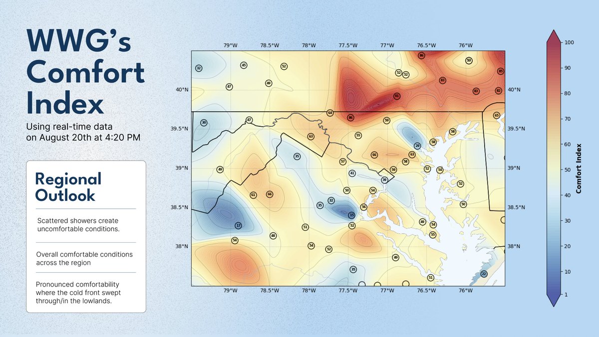
Though the weather is relatively quiet today, it's a pretty comfortable outside for most of the DMV! Though cloudy, today is a great day to go on a walk if it's not raining where you're at. Editor's note: We're rolling out something new we made which is the plot you see below.
1
3
21
RT @NWS_BaltWash: Tidal levels are increasing due to persistent easterly winds. Moderate flooding (water approaching businesses) is forecas….
0
16
0
Many have probably seen the westward trends with Hurricane Erin. Though, impacts will remain limited in the DMV. Minor to moderate coastal flooding is expected tonight along the Chesapeake Bay & Potomac River due to onshore flow from Erin. Coastal flood alerts are in effect

0
2
11

RT @NHC_Atlantic: 2am EDT Aug 19th: Besides #Erin, we are watching 2⃣ more areas for TC genesis in the Atlantic. 1) Central Tropical Atlan….
0
345
0
🚌📝Tomorrow is the first day of school for some across the region!. Looking at the morning, it will be a much more comfortable but gloomy start to the day, with cooler temperatures and widespread cloud cover. Some PM showers and potentially some storms will also be possible


2
3
17
RT @NHC_Atlantic: 8/17 evening: In addition to #Erin, the tropical wave in the eastern Atlantic now has a medium🟠chance of tropical cyclone….
0
611
0

TROPICS UPDATE: Last we reported on Erin, it was a tropical storm. Now, it has rapidly intensified into an extremely dangerous Category 5 hurricane. Current NHC forecast has Erin tracking out into sea which would bring little if any impacts to the DC region. However, this


2
3
26
RT @NWS_BaltWash: A cold front which moved through overnight will continue to drop southward into this weekend. Temperatures remain seasona….
0
11
0
RT @CleanAirPartner: Good weather & we're forecasting good 💚 #AirQuality throughout most of the #Baltimore-#WashingtonDC region this #weeke….
0
1
0
A Severe Thunderstorm Warning is in effect for Baltimore and Harford counties as well as the City of Baltimore until 4:00PM. Main hazard is 60mph damaging winds! Seek shelter! #mdwx
0
4
13
RT @NWSMARFC: [Thursday 03:29PM] Mesoscale Precipitation Discussion Areas affected. portions of Maryland and vicinity Valid from 3:27 PM t….
0
1
0
