

WTVA Weather
@WTVAWeather
Followers
33,882
Following
25
Media
7,362
Statuses
36,514
The @wtva9news Severe Weather Authority for North Mississippi and West Alabama. 24-7 weather information.
Tupelo, MS
Joined March 2010
Don't wanna be here?
Send us removal request.
Explore trending content on Musk Viewer
#ขวัญฤทัยตอนจบ
• 574087 Tweets
オーロラ
• 477961 Tweets
Joost
• 327556 Tweets
jeonghan
• 127459 Tweets
Fulham
• 79631 Tweets
#SixTONESANN
• 76439 Tweets
Man City
• 74328 Tweets
#الهلال_الحزم
• 61542 Tweets
自分これ
• 61279 Tweets
HeavenlyVoice WithMrC
• 54936 Tweets
Gvardiol
• 51763 Tweets
Ali Koç
• 44051 Tweets
カクレンジャー
• 38465 Tweets
太陽フレアのせい
• 38155 Tweets
キンスパ
• 37413 Tweets
Dremo
• 36451 Tweets
マリノス
• 29498 Tweets
Burnley
• 27714 Tweets
SUPER READY FOR SUPERNOVA
• 25151 Tweets
SEE YOU NEXT MONTH JIN
• 24910 Tweets
Luton
• 19603 Tweets
Haley
• 18797 Tweets
Dursun Özbek
• 17255 Tweets
#AdayOlAzizYıldırım
• 16137 Tweets
やまとなでしこ
• 13543 Tweets


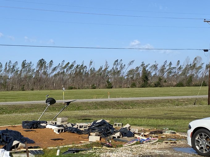
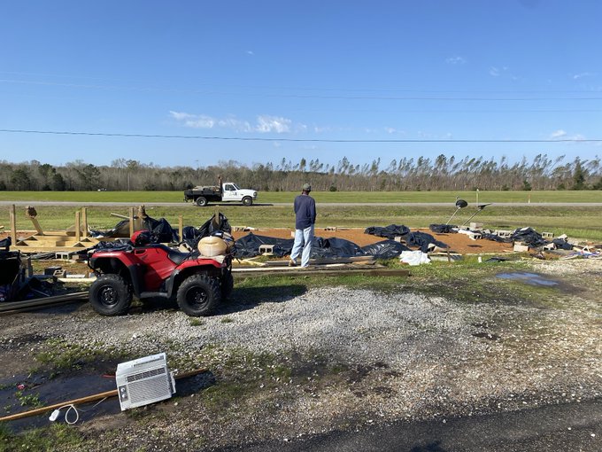
From NMSCAS Ashton Lemely, halfway between Tchula and Eden in Mississippi.
0
31
101
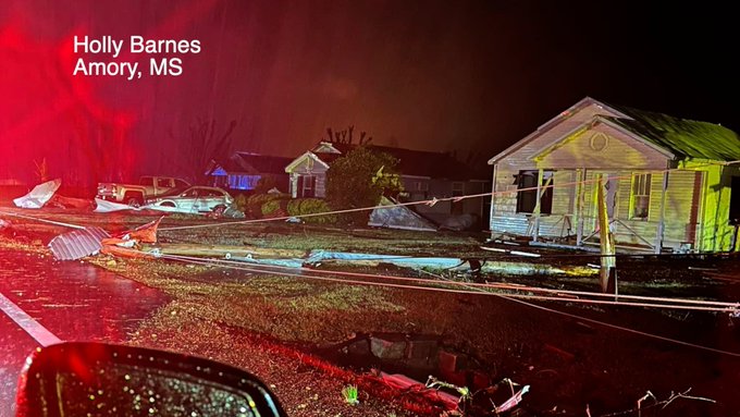
"Dear, Jesus, please help them," WTVA Chief Meteorologist
@MattWTVA
said a deadly tornado approached Amory, MS. |
@matt_laubhan

7
20
85
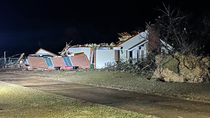
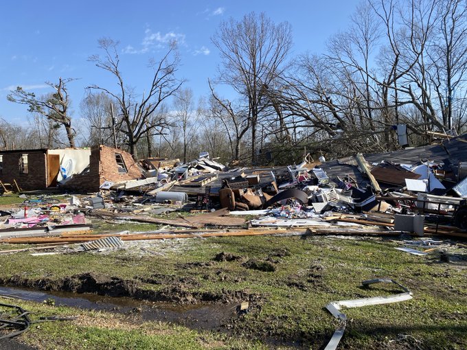
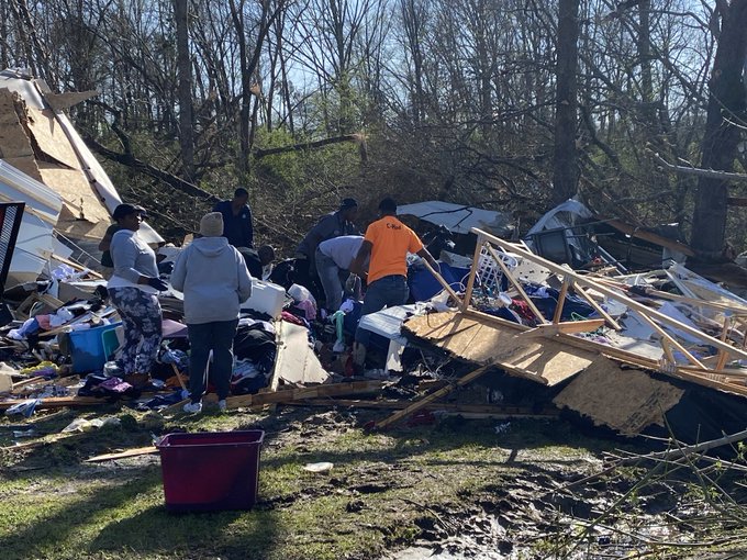
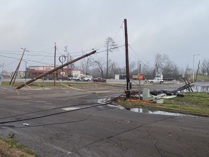
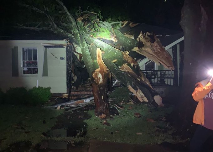
House destroyed on Caledonia Steens Road in Lowndes County.
2
23
48
Possible funnel cloud earlier today between Columbus and Starkville.
1
14
44
2
11
44
Today is meteorologist John Dolusic’s 34th anniversary at WTVA. Johnny D. always makes us laugh and loves talking about pop culture. We’re fortunate to have him here. Picture from the 1900s. 😆

0
7
41
Snow in Alcorn County, Mississippi. Credit: Johanna Ericson.
3
3
40
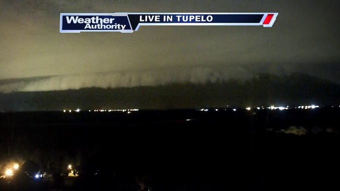
A pretty spectacular lightning show out of our Tupelo Towercam looking N/W. Lightning, heavy rain, and some strong wind gusts are possible as this line moves through.
Updates at 9/10pm on
@wtva9news
.
#mswx
#alwx
1
6
28

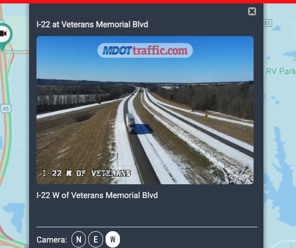
BREAKING: The Natchez Trace Parkway will be CLOSED due to dangerous/impassable driving conditions.
The I-22 bridge is completely iced over, according to Chief Ranger Prashant Lotwala.
#mswx
@NWSMemphis

0
22
27
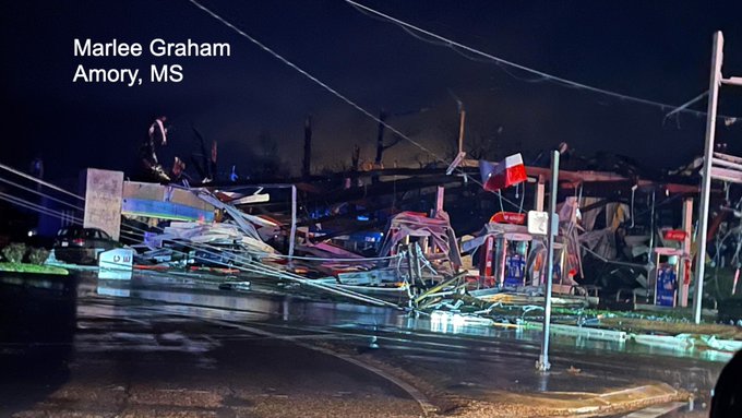
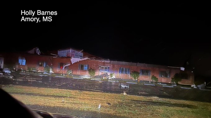
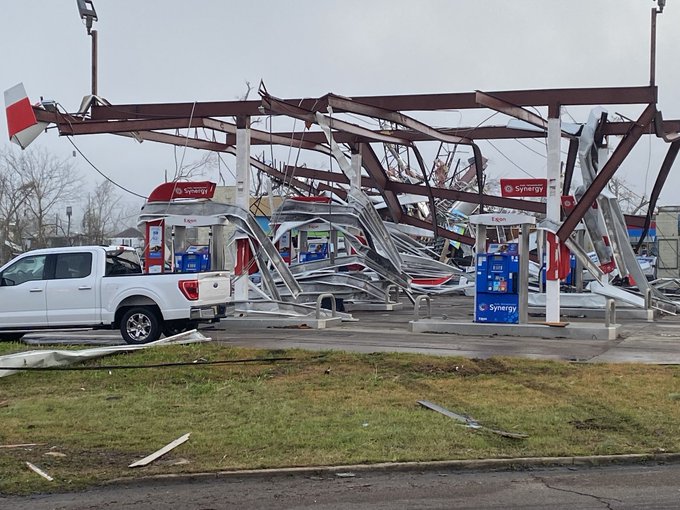
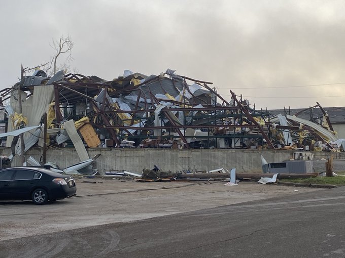
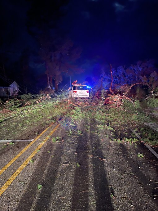
Storm damage at the National Guard armory and nearby buildings in Amory, MS.
5
24
27
Skiing in Tupelo? This is in the Parc Monceau Drive area. From Allie Randle.
2
3
25
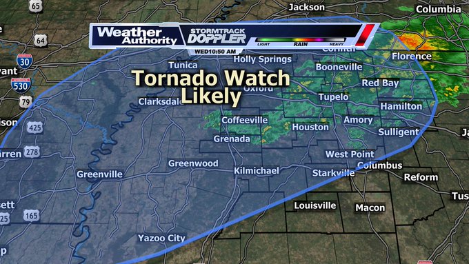
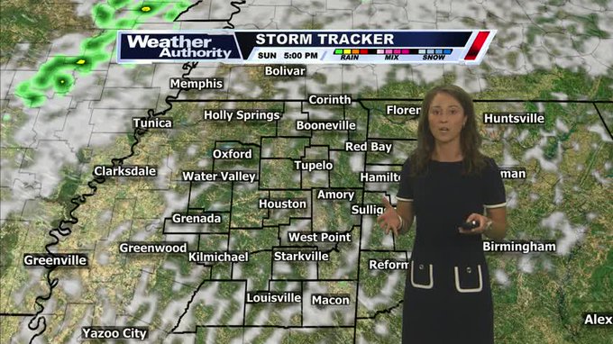
Tornado Watch likely to come in the next two hours for locations highlighted in blue. Updates at noon on WTVA 9 News.
Full discussion/blog:
2
13
24
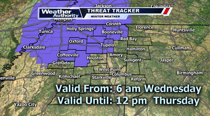
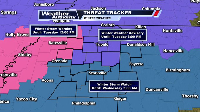
BREAKING: A Winter Weather Advisory has been issued for: Lee, Tishomingo, Prentiss, Tippah, Pontotoc, Union, Alcorn, Yalobusha, Lafayette, and Calhoun counties. Effective from 6 am Wednesday through 12 pm Thursday.
#mswx
1
15
23
CONGRATULATIONS to WTVA meteorologist Alan Matthew and his wife Heather on the New Year's Day birth of their son.
0
1
21
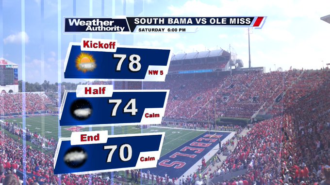
That S. Bama vs. Ole Miss forecast is looking great! Upper 70s kickoff falling into lower 70s by games end.
#mswx
3
8
20
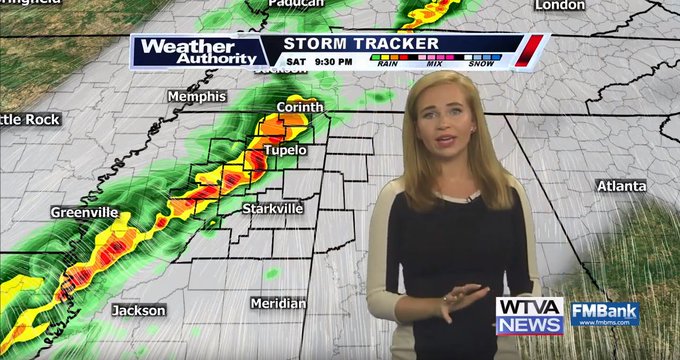
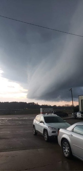
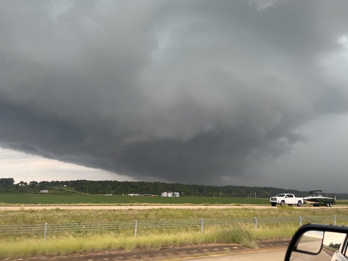
Latest thinking on Saturday's severe weather threat.
Timing remains a huge variable but severe storms producing tornadoes and damaging wind remain possible. Start thinking ahead about your weekend and what changes you might need to make to your plans.
3
14
21
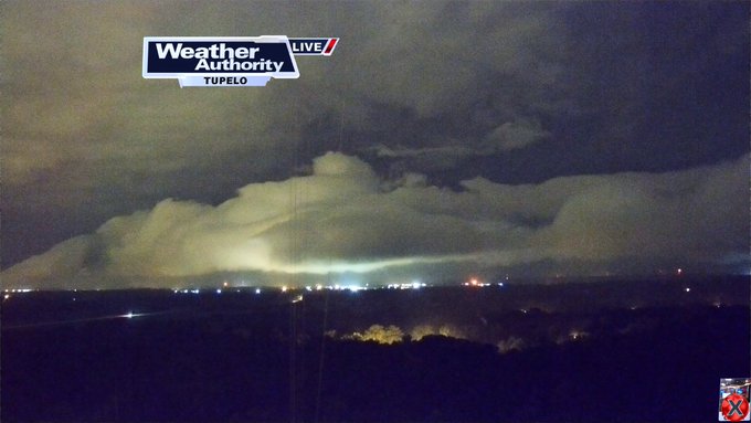
Shelf cloud associated with Severe thunderstorm approaching Tupelo on the Towercam. Expect lots of lightning and possibly winds of 50 to 60 mph w/ this storm.
#wtvaweather
1
9
20
AMAZING VIDEO - A lightning strike narrowly missed a woman in Saltillo.
0
5
18
ALERT: A Winter Storm Watch is in effect until 1/16 6:00PM for the counties in blue.
More info at or in the WTVA Weather App:
0
12
19
WTVA Anchor Emily Leonard and Chief Meteorologist Matt Laubhan look back on April 28, 2014, a day many of us will never forget.

0
1
18

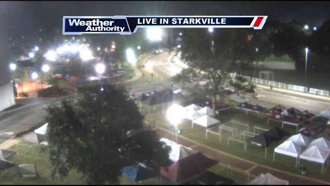
Trees on cars on the Mississippi State campus in Starkville.
0
7
17
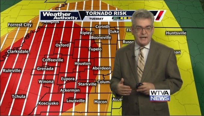
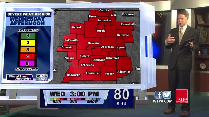
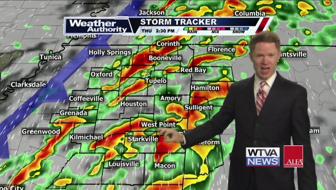
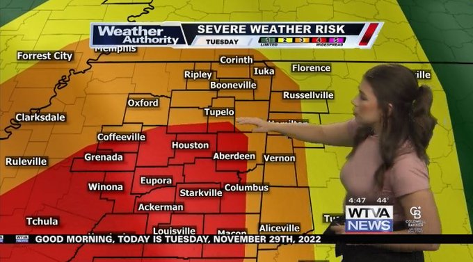
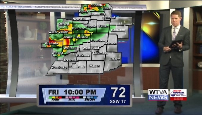
Strong tornadoes will be possible w/some thunderstorms at times. Strong to severe thunderstorms will be the story on our Tuesday afternoon and into our Tuesday night. Your severe weather timeline right here. Here's a look at your latest WTVA Weather Blog:
4
13
17
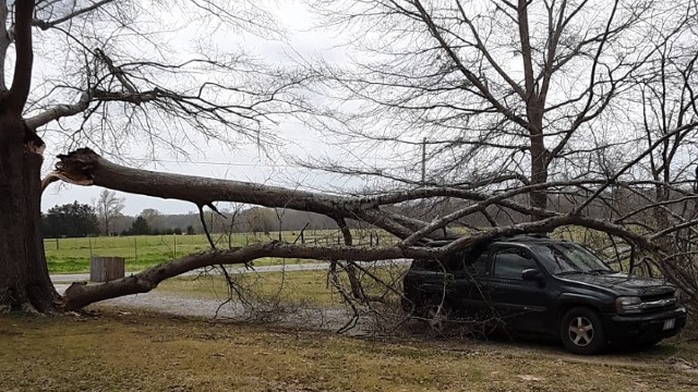
Wind damage in Ingomar (Union County) from Danielle Warren.
1
9
16
More thunderstorms coming soon. Here is a look at the latest WTVA Weather Blog:
1
5
16
In Pontotoc from WTVA's Amanda Haley at approximately 1:17 p.m.
0
7
16
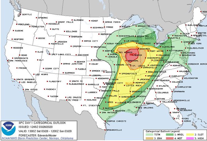
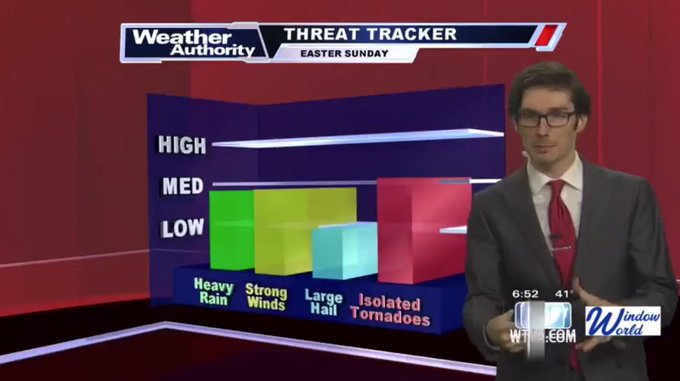
⚠️Severe Weather Risk Tonight⚠️ (3/28) I have also attached the latest SPC Outlook.
🕤TIMING: 8pm- Midnight
☔️IMPACTS: All modes of severe WX are possible.
📋INFO: We'll be tracking a line of storms with supercells likely embedded within.
THE LATEST:
0
7
16
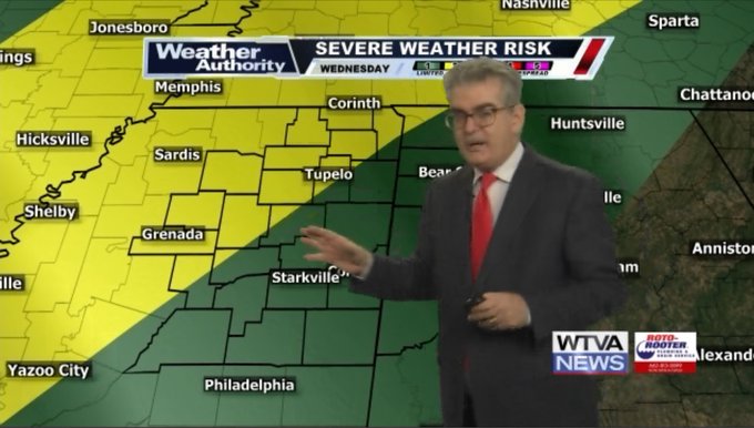
Some strong to severe thunderstorms will be possible on Wednesday and Wednesday evening. Here is the latest WTVA Weather Blog:
0
7
15
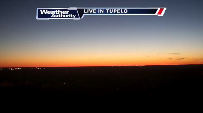
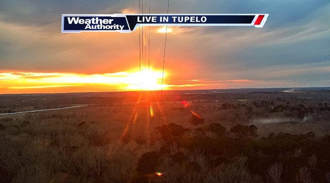
Feeling a little stressed this morning?
Take a deep breath... And look at this sunrise! These views remind us who's in charge. The sun still rises in the east and sets in the west.
It's cold. But we're warming up even more today. Join us on
@WTVA9News
for details.
#mswx
#alwx
0
3
15
ALERT: A Winter Weather Advisory is in effect until 1/18 7:00PM for the counties in light purple.
More info at and on
@WTVA9news
0
13
13
50s!! 50s!! 50s!! Are you ready for some towns down into the middle to upper 50s for overnight lows? We have that in our forecast. Here is a look at the latest WTVA Weather Blog:
0
4
15
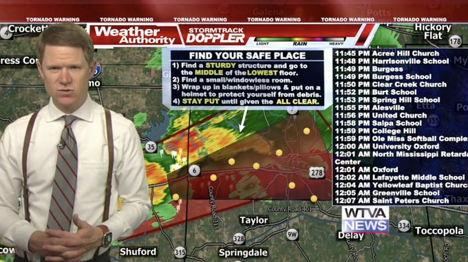
ALERT: A Tornado Warning is in effect until 3/24 9:00PM for Lafayette, Yalobusha, Panola, Tallahatchie. Seek shelter on the lowest floor of a sturdy structure, now.
LIVE:
1
12
10

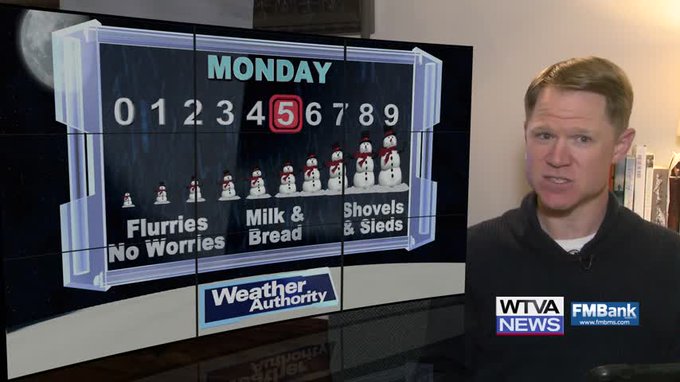
Some severe thunderstorms will be likely on our Easter Sunday. Here is a look at the latest WTVA Weather Blog:
0
7
15
ALERT: A Winter Weather Advisory is in effect until 1/06 6:00PM for the counties in light purple.
More info at and on
@WTVA9news
1
19
15
WTVA ALERT: A Severe Thunderstorm Warning is in effect. Damaging wind and large hail are possible.
More info at and in the
@WTVAweather
App.
#mswx
1
9
15
Some strong to severe thunderstorms will be possible on our Thursday. Here is a look at your latest WTVA Weather Forecast and Weather Blog:
1
8
15

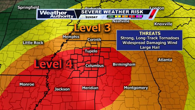
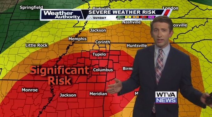
WHAT WE'RE TRACKING: A significant risk for tornadoes, widespread damaging wind and hail is at hand for Easter Sunday. We're breaking down the details right now on
@WTVA9News
TODAY.
#mswx
#alwx
WATCH LIVE:
0
10
13
All forms of severe weather are possible today, but IF tornadoes can form they could become strong and long lived. Peak timing in the afternoon/evening. Tune in for updates this morning on
@wtva9news
1
8
14
A (currently) unnamed tropical disturbance in the Gulf of Mexico is going to work with an approaching front to bring soaking rainfall Friday/Saturday. Rain totals 3"-5" in spots could cause flash flooding (especially Friday Night), with storms on Saturday.
0
11
14
Damaging winds & tornadoes continue to look likely Saturday morning.
Peak Timing: Saturday 8am-1pm
Movement: From SW to NE (possibly as fast as 60-70mph)
Impacts: Damaging winds (some even before the storms move through) and tornadoes (some strong)
#mswx
0
23
14
Strong to severe thunderstorm on our Friday evening. Some tornadoes will be possible and some tornadoes may be on the strong side. Stay weather alert on Friday evening and into Saturday morning. Here is a look at your latest WTVA Weather Blog:
1
7
13
ALERT: A Winter Weather Advisory is in effect until 2/01 12:00PM for the counties in light purple.
More info at and on
@WTVA9news
2
11
14
The snowfall is gone and now we will see some milder temperatures in our weather forecast. Here is a look at the latest WTVA Weather Blog:
0
3
14
David Keeton said he shot these in Saltillo at 1:13 p.m. and 1:37 p.m.

1
1
14
WTVA ALERT: A Severe Thunderstorm Warning is in effect. Damaging wind and large hail are possible.
More info at and in the
@WTVAweather
App.
#mswx
1
10
14
ALERT: A Tornado Warning is in effect until 10/12 9:45PM for Pontotoc, Lafayette. Seek shelter on the lowest floor of a sturdy structure, now.
LIVE:
0
14
11
Some clouds will be passing through our area this afternoon but will move out for the start of our work week.
THE LATEST:
0
1
13
Severe weather risk upgraded overnight, this is for Tuesday afternoon and evening. All forms of severe weather are possible. Tune into
@wtva9news
this morning to get a full breakdown.
3
9
13
SNOW flurries seen Friday morning in Tishomingo County, Mississippi.
0
4
13
Beautiful sunset in progress this evening over northeast Mississippi.
If you catch a glimpse, ---> share it
#wtvaweather
#mswx
#alwx
0
6
13
ALERT: A Winter Weather Advisory is in effect until 2/26 10:00AM for the counties in light purple.
More info at and on
@WTVA9news
0
11
12
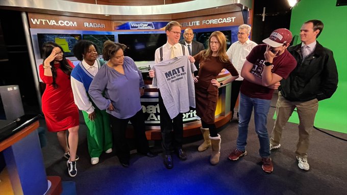
Smithville renames street in honor of WTVA Chief Meteorologist Matt Laubhan.

3
1
13
Every four years, we get an extra day in February. But, why is "Leap Day" even a thing?
0
8
13
"When Matt Laubhan WTVA says safe place, we listen!
#hunkerdown
#safeplace
#weather
#decemberinthesouth
" -Stephanie via FB.
#mswx

0
8
13
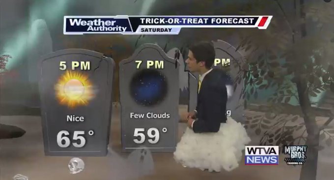
Happy Halloween! Temperatures reach the mid 60s today with plenty of sunshine, dropping into the 50s for trick-or-treat.
THE LATEST:
1
6
12
ALERT: A Winter Storm Watch is in effect until 1/16 6:00AM for the counties in blue.
More info at or in the WTVA Weather App:
0
12
12
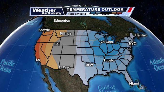
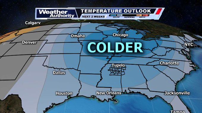
Temperature Outlook: We are tracking an increasing potential for some of the coldest... if not the coldest air of winter to move in. An an updated look at your 7-day forecast coming up shortly on
#WTVA9news
at 5 & 6 p.m. w/ Chief Meteorologist
@WTVAmatt
.
#wtvaweather
#mswx
#alwx
1
8
13
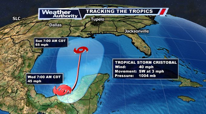
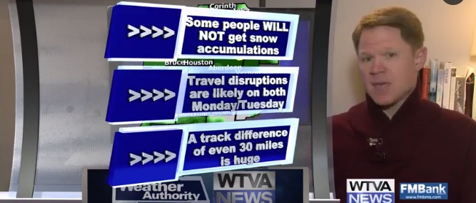
UPDATE: Tropical Storm
#Cristobal
has formed in the Bay of Campeche... This could be an issue early next week for North Mississippi if it indeed takes this track.
Stay tuned for updates in the coming days.
#mswx
#alwx
0
8
13
ALERT: A Winter Storm Warning is in effect until 1/16 3:00PM for the counties in pink.
More info at or in the WTVA Weather App:
0
10
11
Are you ready for some snowfall?? Here is a look at the latest WTVA Weather Blog:
1
4
13
"Sunset in Nettleton. Circle B Ranch." Sent in by Glenda via Facebook.

0
2
11
The severe weather risk in parts of North Mississippi has upgraded to a level 2 out of 5. Large hail and strong winds are the primary threats, but isolated tornadoes are possible this evening. Read the latest WTVA Weather Blog:

1
1
12
Chickasaw County EMA Director Linda Griffin shared this video from CR 413 in Houlka. She reported no injuries. At 9:20 p.m., she said the road is completely blocked and will be blocked for a while due to size of tree.
0
7
11
ALERT: A Tornado Warning is in effect until 4/01 12:30AM for Lafayette, Panola. Seek shelter on the lowest floor of a sturdy structure, now.
LIVE:
0
13
12
It's college gameday and folks are getting ready! It'll be a hot one later today w/ chance of an isolated shower.
0
4
11
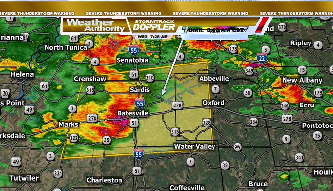
7:26 AM - Damaging straight-line wind is likely blowing across I-55 now through Panola County, moving east at 50-55 mph toward Lafayette County.
I would advise against traveling on I-55 in this area or even along MS 7 from Water Valley to Holly Springs as this moves thru.
#mswx
0
3
12
Getting more and more pictures of damage following last night's tornadoes... This picture was shared by Beau Goodson in Calhoun City.
#mswx
0
7
12
ALERT: A Winter Weather Advisory is in effect until 12/23 6:00AM for the counties in light purple.
More info at and on
@WTVA9news
0
9
12
By Sunday night and into Monday we will see some rain and snow in our weather forecast. Here is a look at the latest WTVA Weather Blog:
0
7
12
A great shot shared by
Anthony Daniels from Aberdeen Lake on this 1st of December evening. Did you catch a glimpse of the sunset? moon? fall colors? Share some 1st of December love.
#mswx

1
2
12
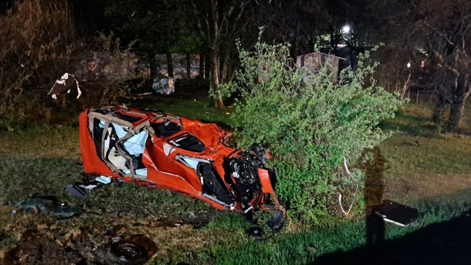
From Josh Mitchell, destroyed van off the side of South Gloster Street near the Choctaw Trail intersection in Tupelo, MS.
1
3
12