

Geography & Environmental Science at Southampton
@UoSGeogEnv
Followers
3K
Following
884
Media
428
Statuses
4K
Welcome to Geography and Environmental Science at the University of Southampton. Join us and together we can help shape the future of our world.
Southampton, UK
Joined November 2012

What will the world look like in a decade? We might have the answer 🌎📊 Our WorldPop experts are launching new global population data, offering insights into where people live, their demographics, and more. Register to watch the launch 👉 https://t.co/M7yNAY1aMD

1
4
5

🚀 Exciting news! In partnership with the UK’s ONS & funded by FCDO, we're introducing automated mapping tech to Malawi’s National Statistics Office. Streamlining the 2028 #census for fast, cost-efficient, and accurate enumeration. #DataForGood #Malawi
https://t.co/bZa7mtqZH3

1
9
18
WorldPop & #UNICEF team up to map zero‑dose children using #AI, satellite data & #geospatial analytics so we can locate and vaccinate those who've never received routine immunisations. Turning high‑resolution data into lifesaving action. #vaccination
https://t.co/BPAYjocDuX

1
5
12
Where are vaccines missing the mark? 🧭🩺 A new study maps vaccine coverage using geostatistics & machine learning - revealing the best tools to find and fix coverage gaps in low-data regions. 🌍📊 #DataForGood #Geostatistics #LeaveNoOneBehind 🔗 https://t.co/taR9ZhdPQu
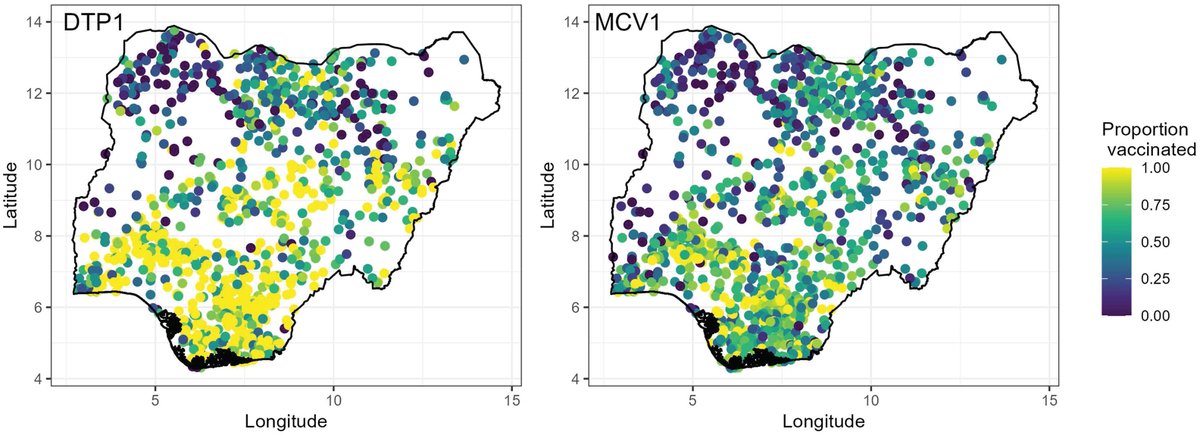
1
3
5
Using #WorldPop data, UNOSAT estimates ~41,000 people remain exposed to floodwaters in KP as of Aug 20, despite receding levels. Pakistan’s monsoon floods since June have caused 785 deaths & widespread damage. #PakistanFloods2025
https://t.co/UDzxRNIGbi

0
1
2
A major shift in South Pacific climate conditions around 1,000 years ago may have drawn people east to settle on more remote islands in the region, moving away from the drier west. New research from @UoSGeogEnv and @unio @uniofeastanglia 👉 https://t.co/sPOPivkpm1

0
1
2
🚨New study co-authored by WorldPop researchers maps malaria risk in #Senegal in detail. Combines environment + vulnerability data to pinpoint hotspots. A powerful tool as the country races toward malaria elimination by 2030. 🔗 https://t.co/plWEHxPj3Y 🌍🦟 #GlobalHealth #Malaria

0
6
9
How do you map populations where no recent census exists? 🌍📊 In this VerySpatial podcast, we share how we use geospatial & satellite data to fill gaps, support UN agencies, and power decisions in crisis zones. 🔊 Listen now: https://t.co/DnjQGMU1le
#DataForGood #Geospatial

0
2
4
🌍📊 WorldPop's cutting-edge research showcased at #JSM2025
#SatelliteData to improve #population estimates - esp. where data is scarce. 📡 >40% less bias. 📍 Smarter models. 🚀 Better decisions for health, aid & planning. #Statistics #DataForGood
https://t.co/g0zzQAMtak

0
4
6
🌍 Big data, big impact! Join us on 4 Sep for the launch of WorldPop Global 2015–2030 - a new open-access, high-res, age & sex-disaggregated population estimate dataset covering 242 countries 📅 4 Sep | 🕒 3 pm BST 🔗 Register: https://t.co/wEh2ZoAx2m
#PopulationData #OpenData

1
13
22
🔥 As extreme heat & aging populations collide #Europe faces a deadly future. A new study using WorldPop data warns heat-related deaths could soar - especially among the elderly - unless bold measures are taken. #ClimateCrisis #HeatRisk #PublicHealth
https://t.co/LKzEQ8CfuQ

1
7
12
🌍 How can data save lives during disasters? WorldPop co-produced high-resolution population data for a new UN study, helping map how vulnerable groups face risks from floods, earthquakes & more. Smarter data = smarter planning. 💡📊 #UNFPA #UNDRR
https://t.co/1G1HfUgzuF

0
3
6
📊 Discover The Power of Population Data! 🌍 Join WorldPop’s webinar on Sept 4 to learn about our new high-res, open-access population datasets (2015–2030) for 242 countries. Learn from experts + get your questions answered! 🔗 Register now: https://t.co/iZjRTfOcfp

0
4
4
🚨 New preprint: 73 high-res, global, multi-temporal geospatial datasets! Covering 2015–2023 at ~100m resolution, these open data power better population modelling for health, policy & more. https://t.co/DvK3XYVOaI

0
3
6
🚨 Big news in population mapping! No more confusing 2.3 people per grid cell. The new WorldPop integerisation method transforms fractional data without losing accuracy. 👉 Learn more, read the preprint & try the tool: https://t.co/PB9KU2w5kZ
#PopulationData #DataScience

1
3
11
🔍 New Greenpeace Intl. study reveals how many people live near petrochemical sites - thanks to WorldPop data! 🌍 Using 2024 population maps, researchers uncovered global pollution risks like never before. 📖🔉🔗 https://t.co/uLhkLFvGVS
#DataForGood #environmentaljustice

0
1
1
Our researchers are working with local councils and food aid services to improve food pantries across the South as the demand for them surges. The project will ensure food is distributed to pantries more fairly and with less waste. Read more 👉 https://t.co/DrVE62QDsU

0
1
4
ConGRADulations - You did it! 🎓✨ Here’s to the Class of 2025 - your future starts now! Be proud, feel inspired and keep reaching for the stars 💪 We are so proud 💙 #WeAreUoS #Graduation2025
4
8
16
🚀 A true honour to welcome Professor Dame Wendy Hall to WorldPop! We had an inspiring & wide-ranging conversation on using AI to fill global demographic data gaps🌍- plus insights into UK data sharing initiatives & the power of interdisciplinary collaboration 💡🔬 #AIforGood

0
4
10
🚨Population Data & #Vaccine Mapping in Focus at Key Global Conferences 👉WorldPop at two major gatherings this month – placing the spotlight on the power of data to drive progress in health and development #SpatialStatistics #DataForDevelopment #SDGs
https://t.co/gsxHXs50Re

0
1
6