
UW-Madison CIMSS
@UWCIMSS
Followers
27K
Following
37K
Media
8K
Statuses
13K
NOAA's Cooperative Institute for Meteorological Satellite Studies (since 1980) at the University of Wisconsin-Madison, the birthplace of satellite meteorology.
Madison, WI
Joined July 2014
ICYMI, Himawari-9 Ash RGB images captured a signature of the first recorded eruption of Krasheninnikov on the Kamchatka Peninsula of Russia, which began on August 2. More on the CIMSS Satellite Blog:
0
3
14
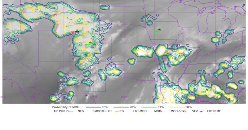
A sequence of 3 Visible, Infrared & Water Vapor images from @NOAASatellites #GOESEast showed rapidly-developing thunderstorm overshooting tops over south-central Wyoming on July 30 -- an aircraft flying just SE of those t-storms encountered extreme turbulence, which injured 25.
1
4
7
Nighttime Microphysics RGB and daytime True Color RGB images from @NOAASatellites #GOES18/#GOESWest revealed the cyclonic circulation of an actinoform cloud feature as it passed just north of the Hawaiian Islands on 30 July.
2
9
40
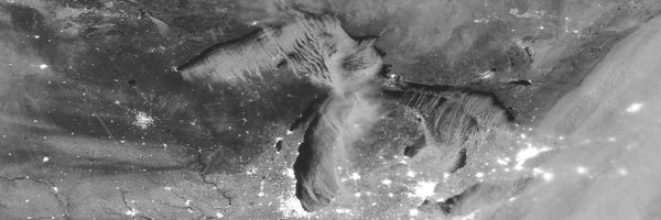
The train of gravity waves was not as apparent in more moisture-rich areas like eastern Missouri -- but an arc of clouds was forming along its leading edge. A Pilot Report noted Light-Moderate Turbulence at altitudes of 11-15 kft over the St. Louis MO area.

0
0
4
Mid-level Water Vapor images from @NOAASatellites #GOES19/#GOESEast showed that an outflow boundary from a decaying Mesoscale Convective System over northern Iowa (which produced a few wind gusts >50 knots) also created a vertically-propagating gravity wave that moved S and SW.
1
17
51
1-minute @NOAASatellites #GOES18/#GOESWest Infrared (+ the Fire Mask derived product) & Visible images showed that the #DragonBravoFire in Arizona produced 3 #pyrocumulonimbus clouds (shades of blue in the Infrared images) late in the day on 27 July. @NWSFlagstaff #AZwx
0
3
12
1-minute #GOES18/#GOESWest Infrared (with the Fire Mask derived product) and Visible images showed that the #MonroeCanyonFire in Utah produced 2 #pyrocumulonimbus clouds (shades of blue in the Infrared images) late in the day on 25 July. @NWSSaltLakeCity #UTwx h/t @mn_storm
0
2
17
More about this event is available on the CIMSS Satellite Blog:
cimss.ssec.wisc.edu
1-minute Mesoscale Domain Sector GOES-19 (GOES-East) Visible images (above) showed the rapid development of thunderstorms that produced strong wind gusts across parts of northeast Illinois and...
0
1
3
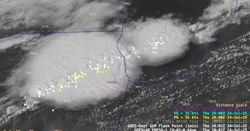
1-minute @NOAASatellites #GOES19/#GOESEast Visible and Infrared images (with overlays of GLM Flash Points and Peak Wind Gusts) showed severe thunderstorms that forced Ground Stops to flight operations at Chicago's Midway and O'Hare airports this afternoon. #ILwx
2
5
14
5-minute @NOAASatellites #GOES18/#GOESWest True Color+Nighttime Microphysics RGB images showed a Mesoscale Convective Vortex (MCV) that was migrating W-NW from southern AZ to southeast CA during the 16-18 July period. More on the CIMSS Satellite Blog:
0
1
20
More imagery of the #CramFire can be found on the CIMSS Satellite Blog:

cimss.ssec.wisc.edu
1-minute Mesoscale Domain Sector GOES-18 (GOES-West) GeoColor RGB images with an overlay of Next Generation Fire System (NGFS) Fire Detection polygons (above) showed the rapid growth of the Cram Fire...
0
0
3
1-minute @NOAASatellites #GOES18/#GOESWest GeoColor RGB + Next Generation Fire System fire detection polygons showed explosive growth of the #CramFire in Oregon on 14 July - as it increased to over 10,000 acres in size, forcing evacuation orders to be issued. #ORwx @NWSPendleton
1
6
11
Two @NOAASatellites #NOAA21 #VIIRS GeoColor images (with an overlay of Fire Radiative Power) at 1755 UTC & 1943 UTC on July 10 showed a large wildfire in western Ontario that produced a #pyrocumulonimbus cloud - more on the CIMSS Satellite Blog:
0
2
5
10-minute @NOAASatellites #GOES19/#GOESEast Infrared images (along with the Fire Mask product) showed that a wildfire in western Ontario produced a large #pyrocumulonimbus cloud on July 10 -- more on the CIMSS Satellite Blog:
0
2
7
5-minute @NOAASatellites #GOES19/#GOESEast Infrared images showed the thunderstorms that produced heavy rainfall which led to deadly flash flooding in Ruidoso, New Mexico on 08 July - more on the CIMSS Satellite Blog: @NWSAlbuquerque #NMwx
0
2
5
5-min @NOAASatellites #GOESEast Infrared images showed the initial period when t-storms produced very heavy rainfall across the Texas Hill Country - producing catastrophic flash flooding resulting in > 80 fatalities. More on the CIMSS Satellite Blog: #TXwx
2
34
74
ICYMI, the thermal signature and smoke plume from an explosion at a fireworks facility in Esparto, California on July 1 were captured by imagery from @NOAASatellites #GOES18/#GOESWest and #GOES19/#GOESEast: @NWSSacramento #CAwx.

cimss.ssec.wisc.edu
A major explosion at a fireworks warehouse in Esparto, California occurred late in the afternoon on 01 July 2025, injuring 2 with 7 people remaining unaccounted for (media report). The robust thermal...
0
2
5
This past Saturday, a wildfire in the Northwest Territories of Canada produced a large #pyrocumulonimbus cloud -- more on the CIMSS Satellite Blog: H/T @mn_storm
0
1
6