

UK Weather Updates
@UKWX_
Followers
32,745
Following
126
Media
15,952
Statuses
53,454
Amateur weather enthusiast from Wakefield. Providing balanced UK weather commentary, frequent severe weather updates, model insights & severe weather graphics.
United Kingdom
Joined September 2014
Don't wanna be here?
Send us removal request.
Explore trending content on Musk Viewer
Northern Lights
• 146703 Tweets
オーロラ
• 138107 Tweets
#aurora
• 110495 Tweets
Knicks
• 77770 Tweets
Pacers
• 53547 Tweets
#solarstorm
• 49138 Tweets
BECKY X MAYBELLINE LIVE
• 46350 Tweets
Game 4
• 42641 Tweets
#REBECCAPINKLOVELIVE
• 36133 Tweets
Ushuaia
• 34536 Tweets
Brunson
• 34368 Tweets
melanie
• 33784 Tweets
Timberwolves
• 31299 Tweets
BUMP
• 27511 Tweets
#キントレ
• 26768 Tweets
Protection Campaign
• 23752 Tweets
HBD LINGLING KWONG
• 22705 Tweets
#MenolakLupa271T
• 18746 Tweets
UsutTuntasRBT UsutRBS
• 18602 Tweets
Nembhard
• 16705 Tweets
Hughes
• 16321 Tweets
バチコン
• 11918 Tweets


Pinned Tweet

Currently doing an MSc in Meteorology and procrastinating by being a weather nerd here on Twitter providing updates asks for fuel. ☕️
If you're feeling generous, feel free to support me by chipping in for a coffee or two! I'll greatly appreciate it! 🫶

5
4
47
There's been a lot of flashes from somewhere south of me.. and that is definitely not lightning.
46
80
409
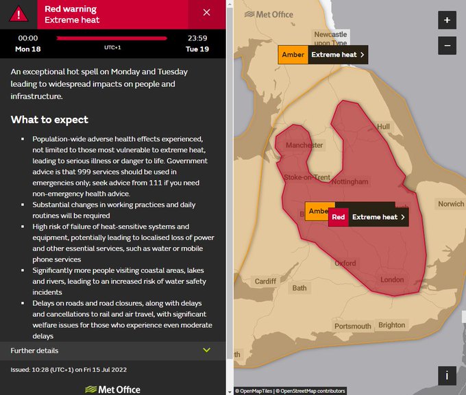
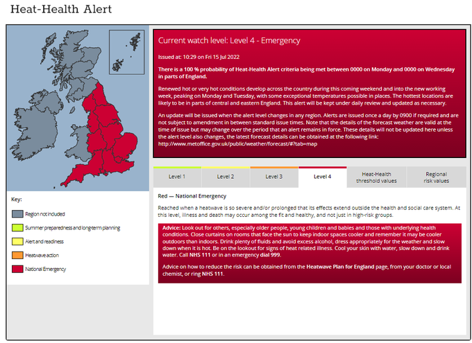
⚠️⚠️ BREAKING ⚠️⚠️
A RED extreme heat warning has been issued for Monday into Tuesday across large parts of England.
A LEVEL 4 red alert has been issued, meaning that a national emergency is now in place.
This IS serious.
65
181
405
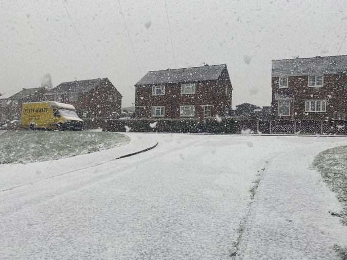
I was going through my camera footage to try and make a timelapse of the snow on Sat morning when I caught this. I'm a bit freaked out.
There must have been something.. because snow did fall off the lamp post down the road, can clearly see it! Power went out around this time too
83
67
400
There was a very bright meteor at around 02:07:26 this morning, looking towards the SSW. Caught it on two of my cameras. ☄️
6
45
369
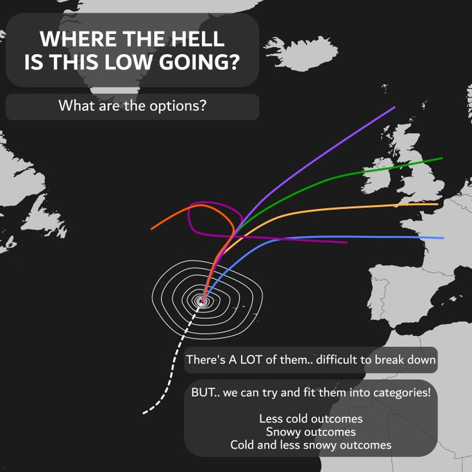
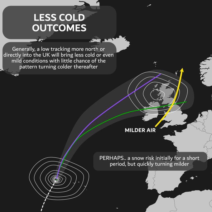
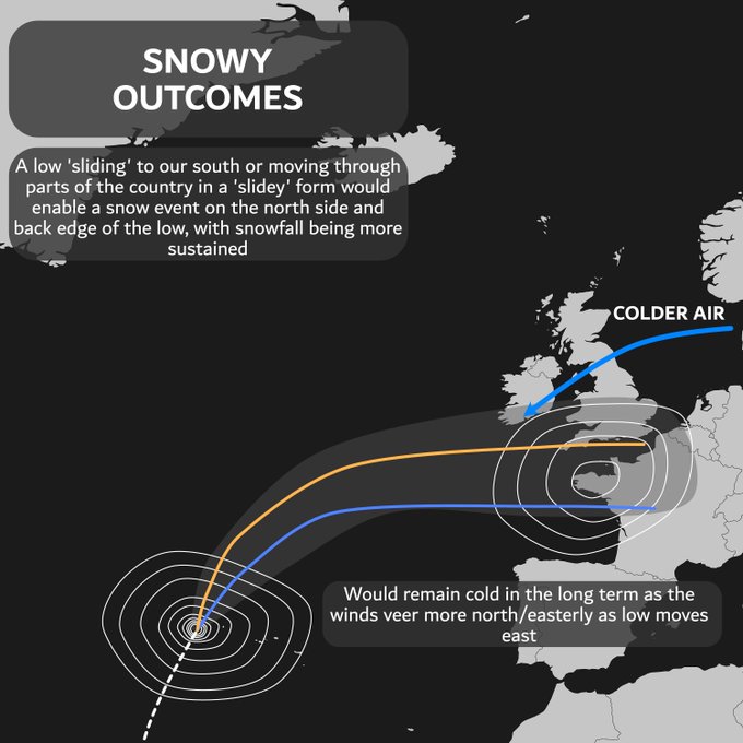
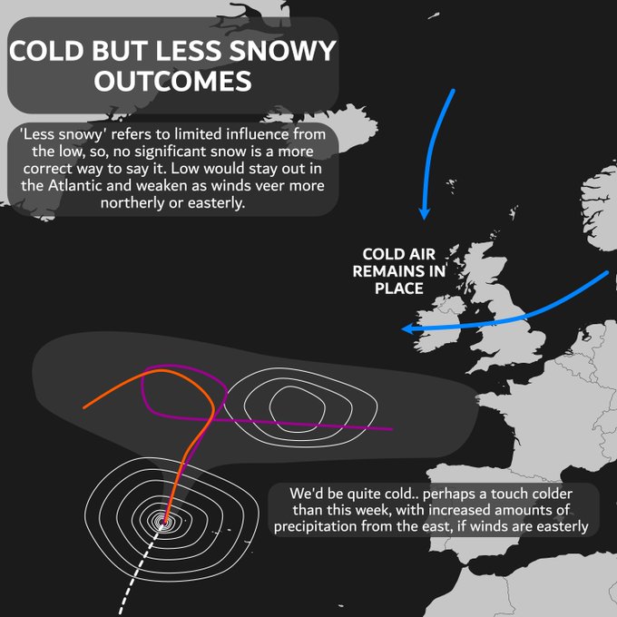
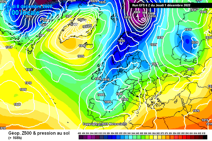
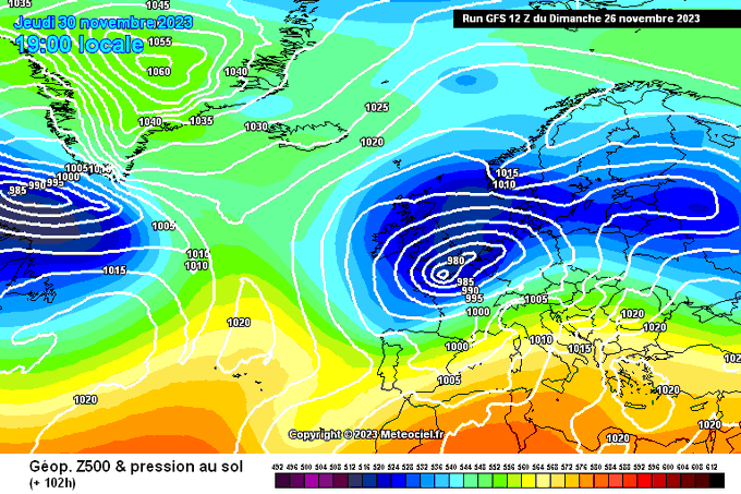
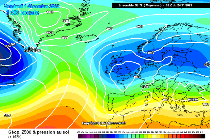
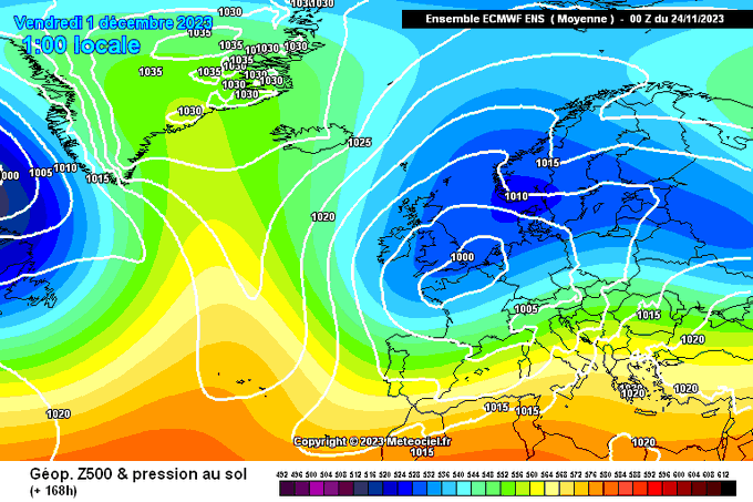
A developing area of low pressure across the Atlantic is causing chaos in long range modelling - there are various options on the table. Below I try to simplify the main potential outcomes with the low.
This is with regards to the period through 11th Dec onward.
14
42
324
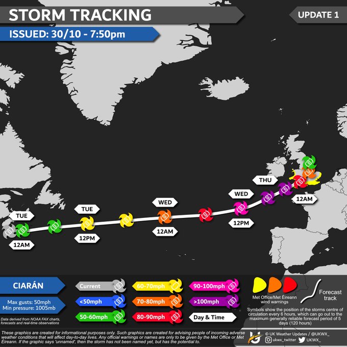
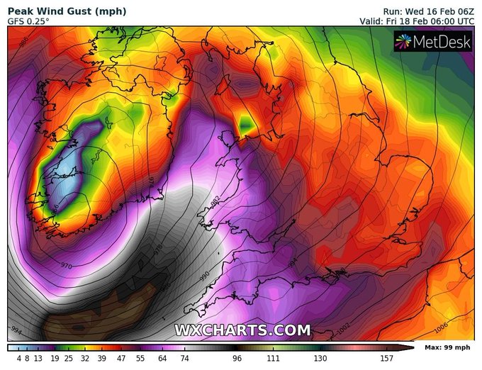
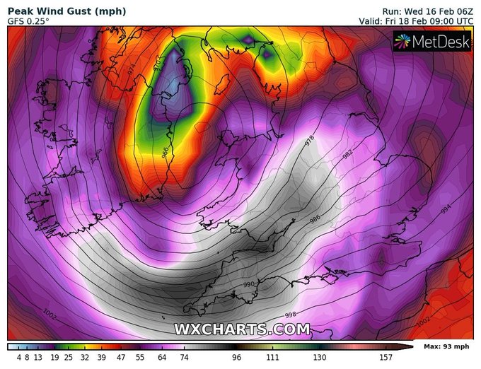
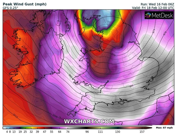
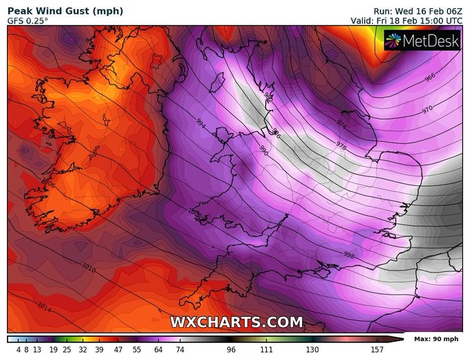
Storm Tracking -
#stormCiar
án
[UPDATE 1] Ciarán is currently located off the coast of Nova Scotia & will rapidly intensify on approach to the UK. There is still some uncertainty on the exact track on approach to the UK, and therefore possible extent & level of impact from wind.
3
87
294
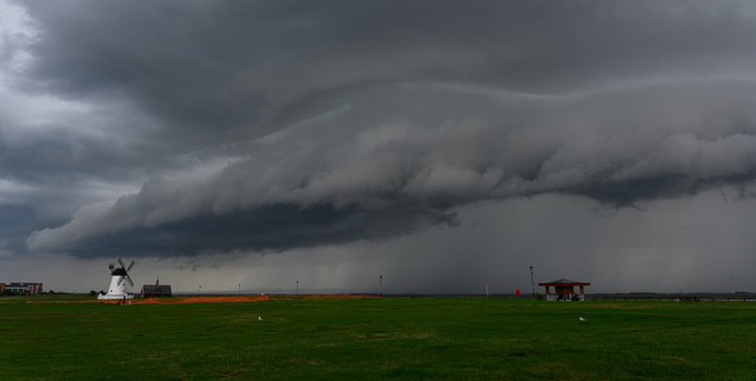
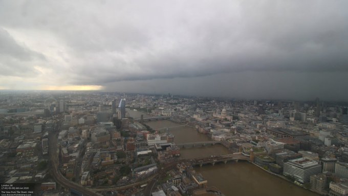
WOW!!! Incredible capture of an approaching severe thunderstorm in Lytham, Lancashire! ⚡⚡ Picture by
@marksmcneill
8
47
266
You see this scene for the first time in 2020, what do you do?
96
26
257
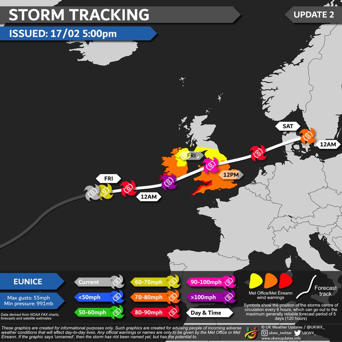
This is not looking good.. I am hoping it gets downgraded, but we're only 72-96 hours out and it just keeps being shown. It's concerning.
#StormEunice
30
59
258
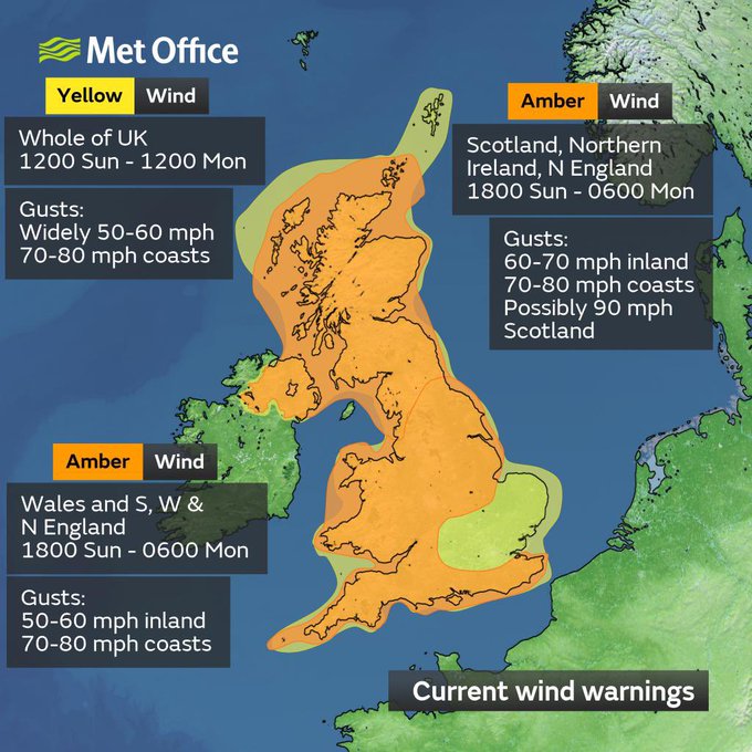
When > 75% of the country is covered in an amber warning for wind, you know the storm means business..
#stormIsha
11
53
241
My camera caught a bright meteor spotted at 18:10:07 UTC from Wakefield looking towards the WSW! ☄️
Anyone else seen it? 😁
32
36
242
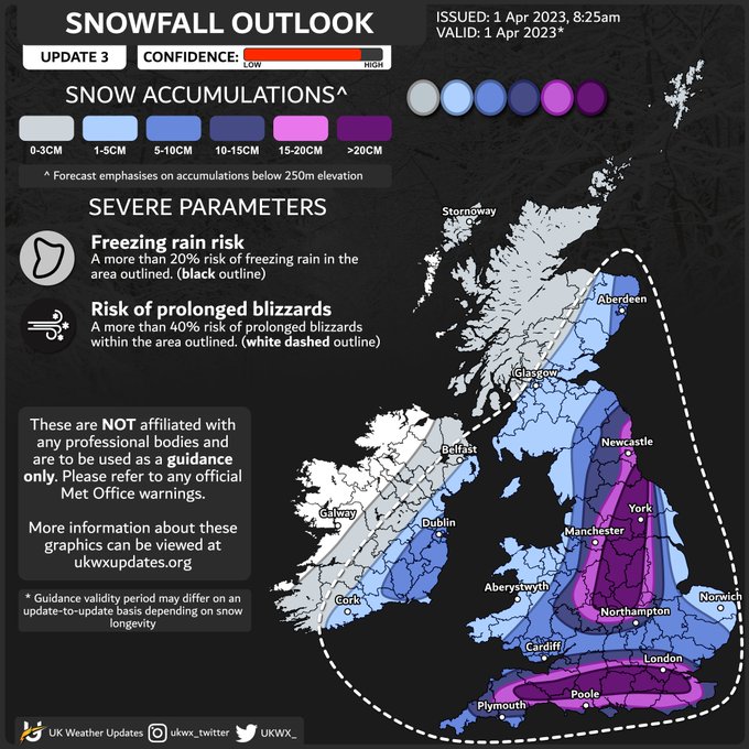
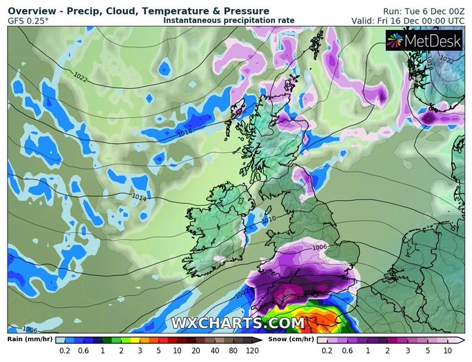
Snowfall Outlook - today
[UPDATE 3] This is the last update for today's significant snow event. Significant snowfall totals expected across N/NE England into Midlands with further significant snow south of the M4. Some spots may see 30-40cm by the end of the day.
86
26
236
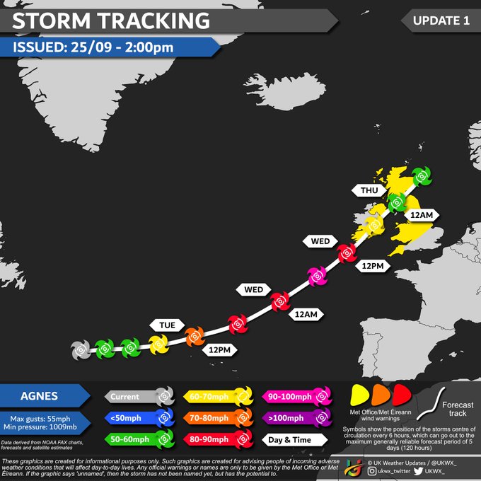
Storm Tracking -
#stormAgnes
[UPDATE 1] Storm Agnes is expected to impact UK and Ireland through Wednesday, bringing locally large rainfall totals and disruptive, possibly damaging, winds. The system is currently developing and should peak in intensity shortly before landfall.
9
75
226
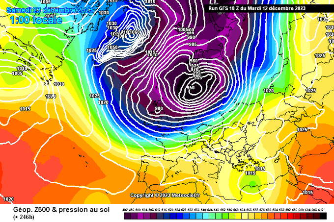
Damn 18z GFS..
Casually dropping a storm for the whole of C/N Europe with a polar airmass set in. Would be quite the nightmare before Christmas.
18
29
228
My gosh.
When you see the ECM - oh, did I mention, 6 days away?
🥶🥶❄️
16
15
219
Remember tomorrow is 2's day
22:22:22 on 22/2/22 on a Tuesday
4
49
215
Officially doing a masters in Meteorology from September. Hopefully a huge step in my future career! 🎉
20
1
215
This is not 'just summer'. Those who said that are a bunch of 🤡's. Let this be a reminder to have some respect to meteorologists and amateur weather enthusiasts who are trying to convey up to date, potentially life saving weather information.
13
23
208
Storm Tracking -
#stormIsha
[UPDATE 2] Storm Isha nearing peak intensity. Wind and rain beginning to push in, with peak winds occurring between 6pm - 6am. There is a small risk of an isolated tornado as it passes through, especially across Ireland and Scotland.
Intensity…
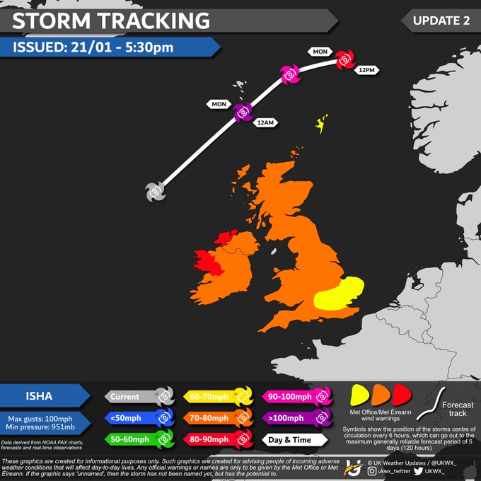
9
56
208
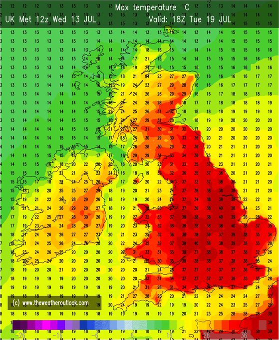
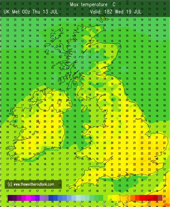
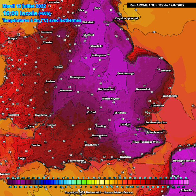
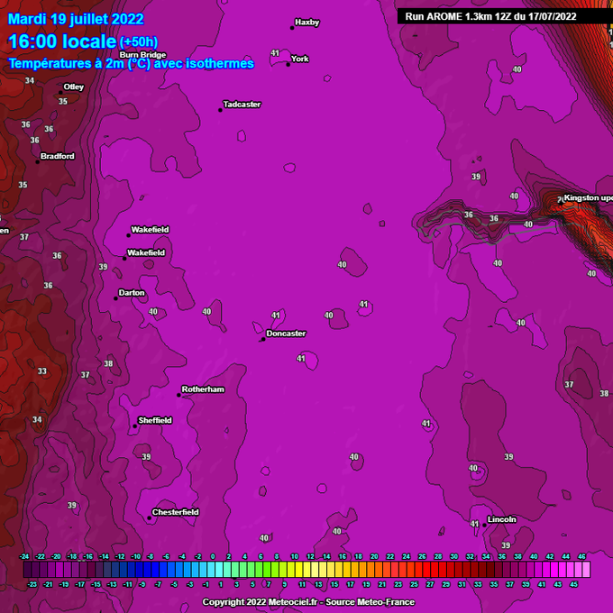
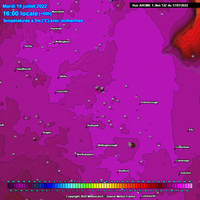
Temperature forecast a year ago today for 19th July 2022, vs today's temperature forecast for 19th July 2023
27
33
203
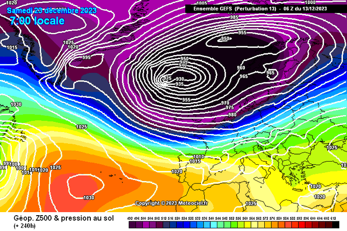
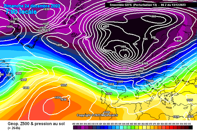
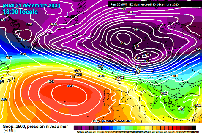
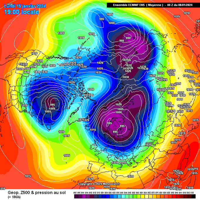
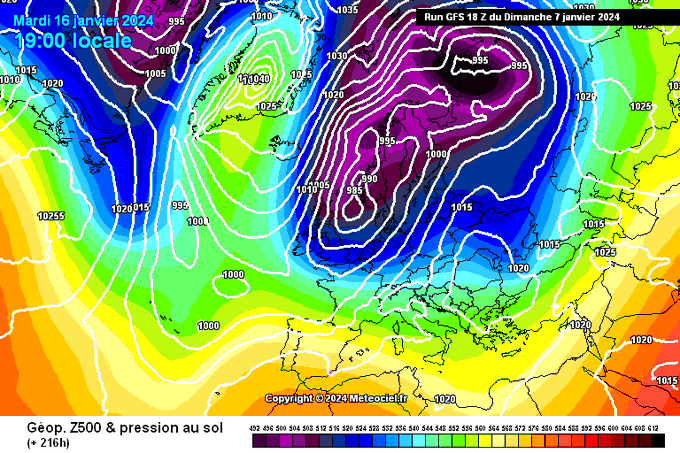
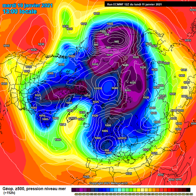
I thought I had seen most of it when the 18z GFS came out last night, but no.. ensemble member 13 takes it! One of the most insane charts I've seen, a ~925mb low to the north of the UK moving SE. Lobe of PV just casually digging into Europe.
Damn 18z GFS..
Casually dropping a storm for the whole of C/N Europe with a polar airmass set in. Would be quite the nightmare before Christmas.
18
29
228
32
19
193
Never in a million years would I have thought to gather such a large following, today we hit 30,000 followers here in Twitter. It's such a large number! 🤯
I started this in winter of 2016-17 as a clueless teenager still learning about the weather, climate, and weather models,…
20
7
196
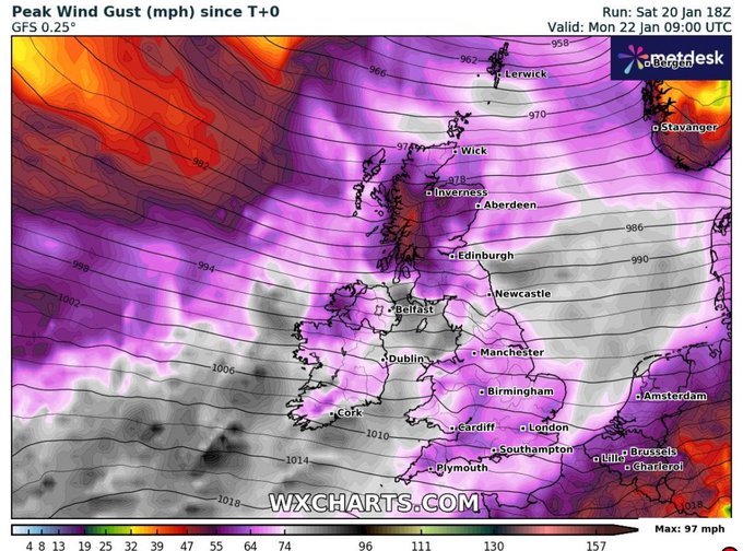
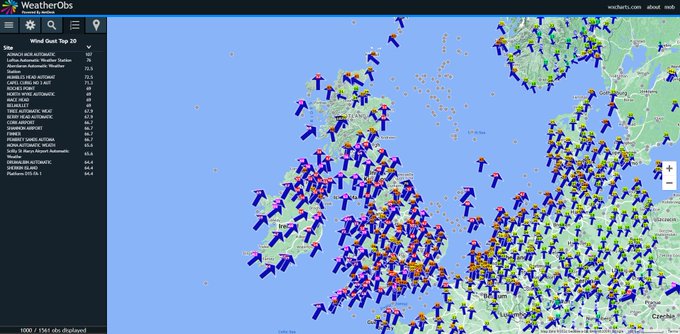
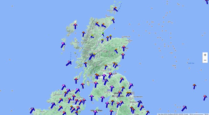
The 18z GFS is more significant in terms of max wind gusts tomorrow. It's going to be a very windy night tomorrow night.. I suspect there's going to be significant disruption come Monday morning. Damaging winds, don't underestimate this storm...
#stormIsha
10
44
193
Winter 2018-19 forecast
A few things we're certain about.
- Colder than summer
- Frosts return
- Snow risk is much higher
- Seas become cooler
19
55
183
Pardon my French, but what an absolute stonker of a run the 6z gfs is
14
12
183
How is Tuesday's snow risk looking at the moment? It's rather uncertain with numerous scenarios still possible, here are 2 graphics outlining the areas at risk and the numerous scenarios. Currently scenario 1 (A) seems the most plausible, but could still change.
#uksnow
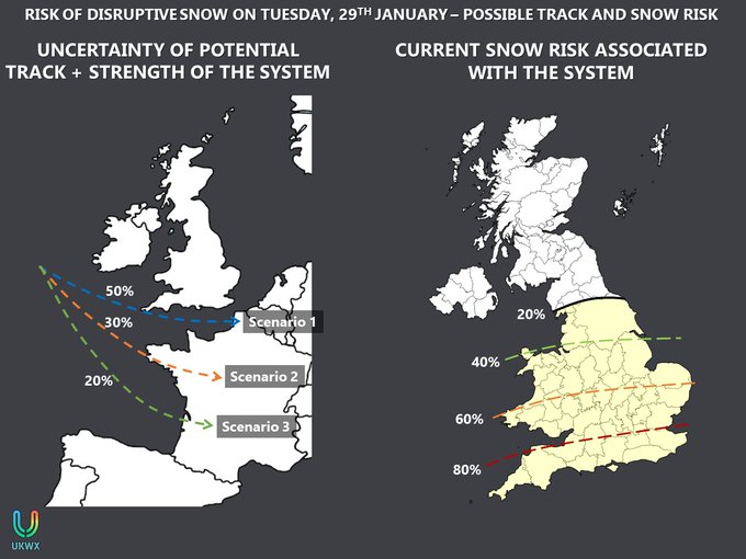
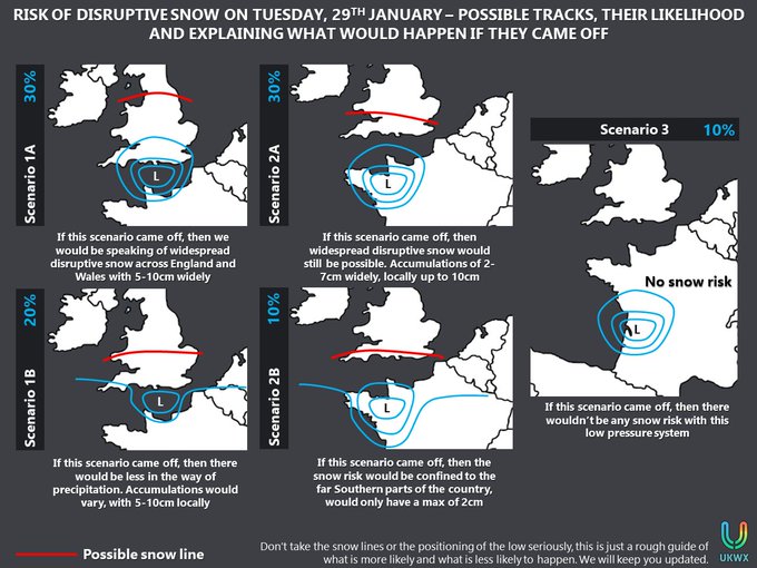
23
57
172
HERE IT COMES
The amplification of the high is well underway! 🎉
DRY weather to last use for at least a week! 🌂
The cold theme may continue well through to mid-month, with an increased risk of more wintry conditions by then. ❄️
Widespread frosts, fog, sunshine, calm!
10
18
178
Let's see how models develop the next few days, shall we? 👀❄️
16
12
175
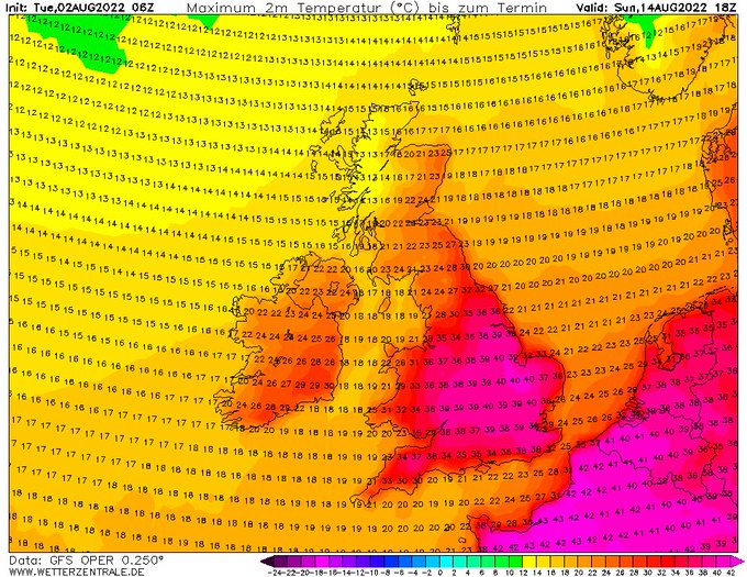
Wow. The swathe of 40°C on the latest AROME for Tuesday. Localised 41-42°C.
This isn't a joking matter. The extent of heat which we have not had in the UK is coming.
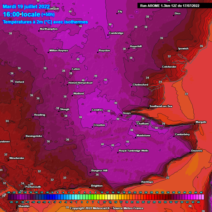
8
46
173
Look at the expanse of colder air over the Arctic through the last half of August - a sure sign that autumn is on our doorstep. 😅
26
24
175
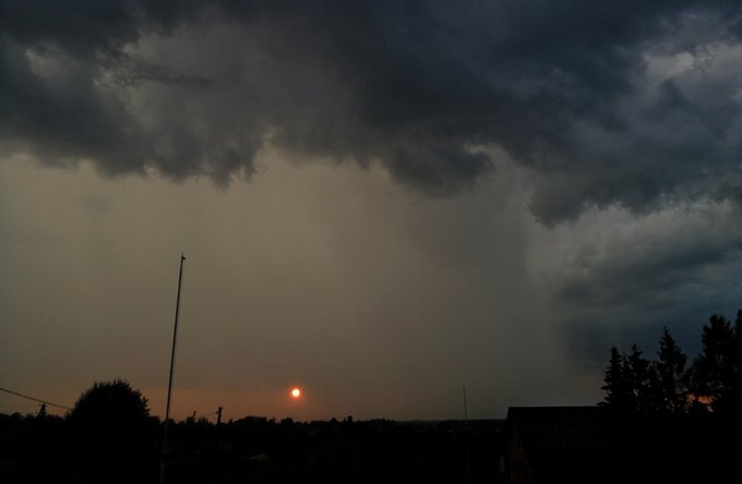
Imagine witnessing a sunset this mesmerising while driving on the way home! 😍
5
25
167
#Stromboli
volcano has erupted once again! It last erupted on 3rd of July..there is a correlation between low solar activity and increased volcanic & earthquake activity.
12
59
155
Freezing fog and a current temperature of -4.8°C back home in Wakefield. If the fog doesn't lift, doubt it will go above 0°C through the afternoon. What an opening to winter! 🥶
19
22
165
Oh ffs GFS.
I did not want to see such charts any time soon. 😩
A very low risk of such, as is always the case >7 days in advance.
25
19
163
The pattern keeps shifting slightly further south with each run, as high pressure is stronger on the modelling. Any further south shifts and we could be pulling in colder, more readily snow conducive air from middle of next week. There is *some* support for that scenario, but…
5
21
162
Also a considerable shift south with the low on Thursday on the 12z GFS. This brings the snow risk southwards.
Encouraging 12z guidance so far in terms of snow risk on Thursday. My eyes are peeled! 👀❄️
Within GFS ensembles a south shift is also present.
28
13
162
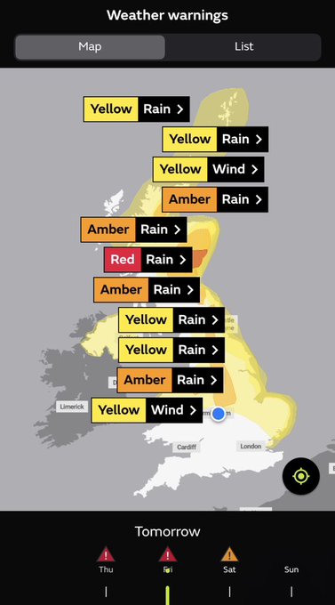
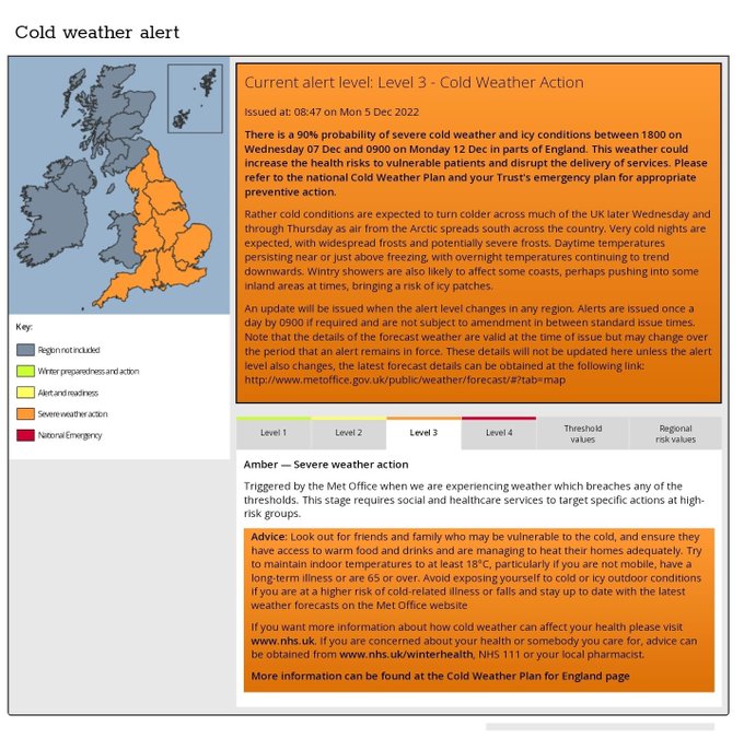
A level 3 cold weather alert has been issued for all of England. If this doesn't show it to be a notable spell of cold weather, I don't know what will.
Think there is a possibility of this to be extended past the 12th by a couple days looking at some of the modelling.
31
40
160
The 12z GFS is an example which would mean big snow business courtesy of a strong easterly flow (heavy wintry showers) and a frontal snow event. Colder 850hPa temperatures are able to make inroads from the east thanks to the low. Would be one way to enter meteorological winter!
7
19
159
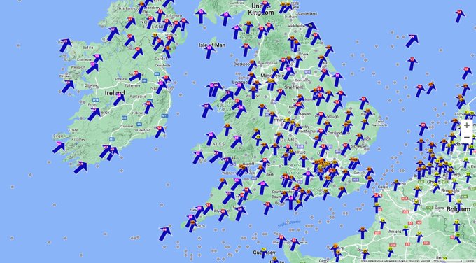
Storm Tracking -
#stormIsha
[UPDATE 1] Isha is expected to deepen over the next 24 hours, and maintain its intensity on approach to the UK; bringing significant winds across the majority of the country. Gusts of 55-65mph are expected widely, with local inland gusts of 70mph…
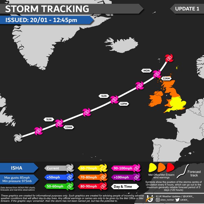
2
34
161
Storm Tracking -
#StormEunice
[UPDATE 1] Storm Eunice will bring a large swathe of dangerous and severe wind gusts across England and Wales, with the risk of potent snowfall on the north side across northern England, Northern Ireland and southern Scotland. Keep updated!
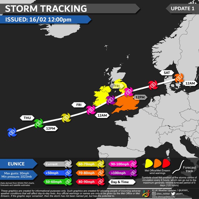
10
48
157
If some good snowfall is what you're after then look no further than day 8-10 charts of this morning's GFS and ECMWF, both bringing a frontal snow event. Obviously will change, but it does show the risk I mentioned yesterday - any lows moving close by to our S may bring sig snow.

16
24
155
From 18th March, days will be longer than nights.
Tonight the sun sets at 17:37 in London, but by 27th March (before clocks go forward) the sun will set at 18:25 and on 28th it won't set till 19:27.
In just 4 weeks time, the sun will be setting at half 7. 😎🕐
7
30
152
Outlook is cold, increasingly cold and wintry from around the 14th!
After today's wintry showers, we're likely to remain largely dry with little risk of snowfall till the pattern change this weekend.
The cold and wintry period mid-month was signaled over a week back.
5
13
151
Caught the meteor around 9:29:51pm to my SSW from Wakefield, sadly outdoor camera didn't quite get it in the frame, so the indoor one with window glare will have to do. 😅
@UKMeteorNetwork
9
17
156
Told ya, 40°C. Insanity.
More places likely to reach 40°C.
9
14
151
Increasingly cold and wintry come 14th/15th. ❄️
Risk of disruptive snowfall at some point next week;
Location specifics unknown
Extent of snow unknown too
So wouldn't pay much attention to deterministic model runs till such potential is shown within the 3-4 day time frame!
6
14
156
18z GFS is a snowfest ☃️
Increased presence of a Greenland high within today's guidance. 🙂
12
17
153
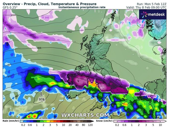
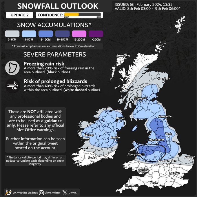
SNOWFALL OUTLOOK
8th February 03:00 - 9th February 06:00
[UPDATE 2] The validity period has been altered for the outlook and a 5-10cm area has been introduced. There is considerable uncertainty in totals, and the exact evolution of the system will determine whether totals in…
19
36
152
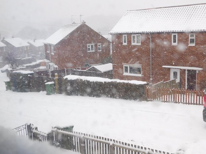
Incredible scenes in London and just SE England in general. A good, well deserved and LONG awaited dumping of snow, especially this early in the season, which wasn't marginal or knife edge like most events seem to be - oh, it's early December too! We had 40°C in July! Perfection.
15
13
152
I open the door and it feels like I walk into the Sahara Desert
20
15
146
The 12z AROME is picking up on extremely strong wind gusts of around 100mph across parts of Republic of Ireland and Northern Ireland. Likely picking up on convective development, with strong straight-line winds and/or tornado risk.
#StormIsha
9
29
149
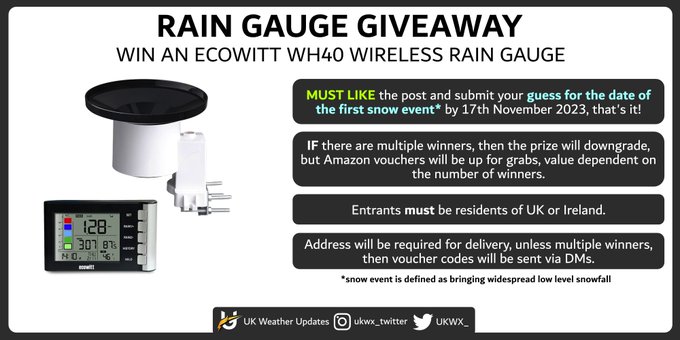
A chance to win an automated Ecowitt WH40 rain-gauge! 🏆
All that's required is to ❤️ the post and submit your guess (by 17/11) for the date of the first snow event* in the UK.
Entrants must be residents of UK or Ireland.
*snow event is defined as widespread low level snowfall
110
8
149
Quite a surprising amount of lightning activity. Much more extensive! ⚡️
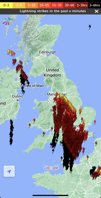
18
17
148
This Saturday, I, James, will be moving in to University and begin a new, important step in my life, for my future career in relation to weather. I don't think it should interfere much with Twitter, so any weather updates should continue as per normal.
Looking forward to it! 😊
30
4
142
This cold spell will bite... bitterly cold nights coming up - any snow cover will make the temperatures at night drop down more drastically. ❄️🥶
9
12
143
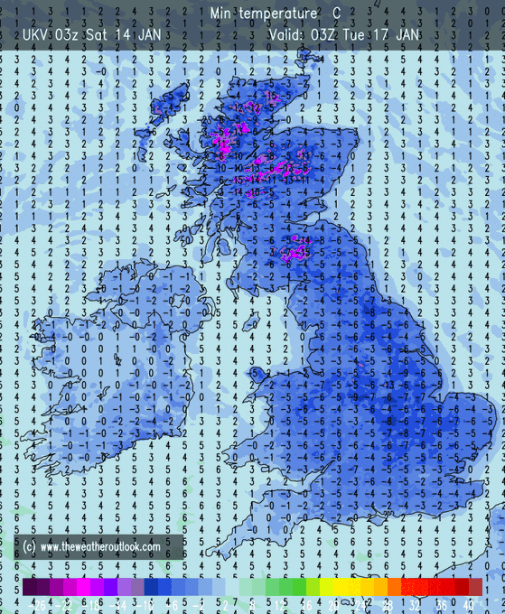
Some bonkers outputs this morning. We may be looking at some quite impressive overnight minimum temperatures by as early as Thursday. The latest ECMWF suggests temperatures widely falling down to -5°C by then.
5
19
140
First time that I have captured a thunderstorm and the sun setting at the same time 😍
2
14
136
An area of high pressure, coming soon, to a town near you! 👀
22
16
138
Soooo.. Another round of heat anyone? 24th August onwards still has the higher pressure signal, accompanied with further heat from the near continent.
Will see.
18
17
140
Storm Tracking -
#StormEunice
[UPDATE 2] Eunice is beginning to rapidly deepen and will do so over the next 12-18 hours. Damaging wind gusts are expected across large parts of southern UK and Ireland. Preparations should be underway in places worst affected.
7
46
139
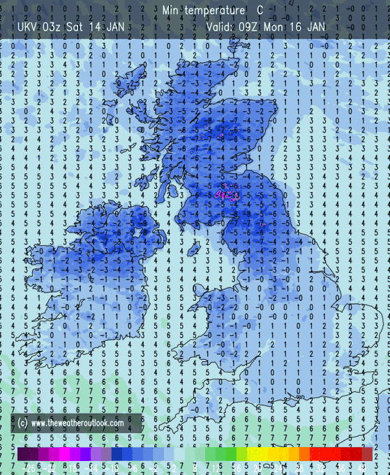
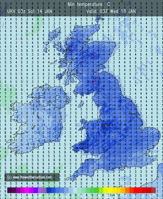
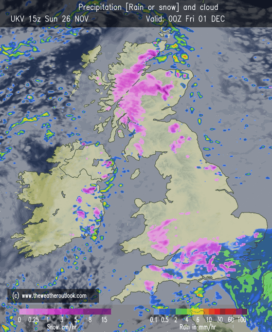
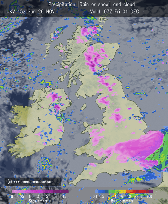
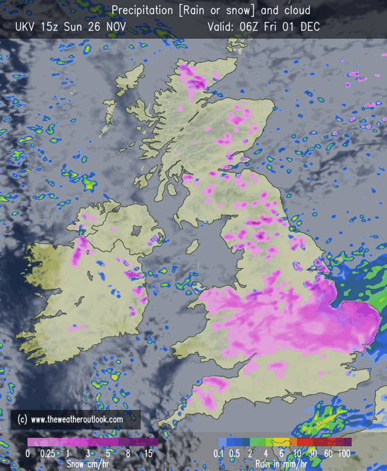
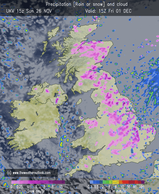
The UKV is in, and it's very eye catching for the snow fans.
*this is not a forecast*
8
19
140
It's beginning to look a lot like Christmas
Everywhere you go
There's a tree in the Grand Hotel, one in the park as well
It's the sturdy kind that doesn't mind the snow
7
10
140

Summer 2019 Forecast:
There are a few things we are certain about.
- High chance of thunderstorms
- Temperatures above 15°C likely for at least 80% of the summer
- Warmer seas, so you can enjoy the beach and get that summer tan
- Sun gets stronger
- Warmer than winter
18
19
132
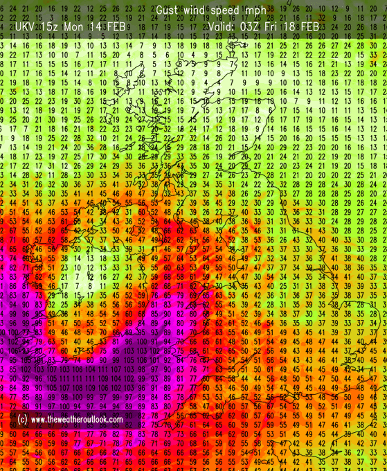
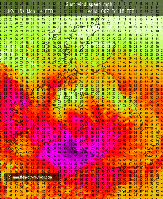
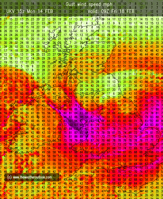
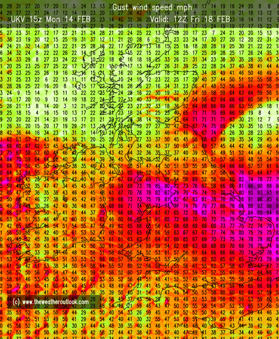
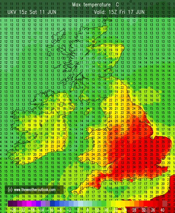
What on earth. This is a bonkers output from the latest UKV for mid-June standards - chart below is for Friday.
Not out of the realms of possibilities, but this is on the upper end of such. 😳
11
24
137
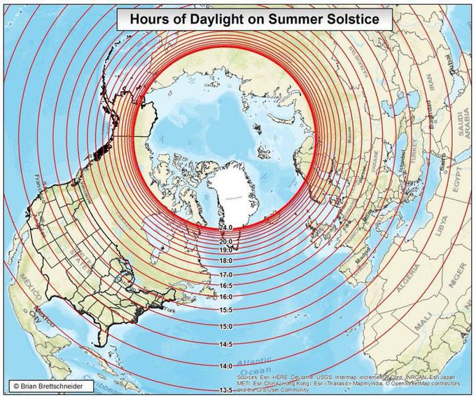
Hours of Daylight on Summer Solstice (21st June). Northern parts of the UK get 17 to 18 hours of daylight whilst south get around 16 to 17 hours; Shetland Isles squeeze 19 hours of daylight. 🌤
6
43
134
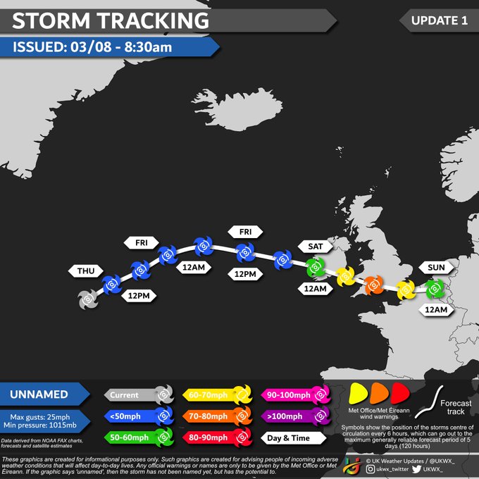
Storm Tracking - UNNAMED
[UPDATE 1] A deep area of low pressure will bring a period of unseasonably strong winds across Ireland and S/SW parts of the UK through Saturday. Trees in full leaf = greater risk of disruption.
7
27
135