Teja Kattenborn
@TejaKattenborn
Followers
781
Following
2K
Media
99
Statuses
444
Professor for Sensor-based Geoinformatics (geosense), University of Freiburg.
Germany
Joined April 2018
Imagine one could infer the global distribution of plant functional traits from citizen science photographs…. Stop imagining it, here´s the Howto: See thread for a summary.

3
36
121

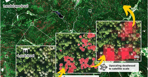
We are currently expanding the temporal and spatial coverage of our tree mortality products (towards global scales). Checkout Looking forward to your collaboration! 🧑🤝🧑🌐🌳🌲. (4/4). @MixedForests @UniFreiburg @Tree_Mortality @KIT_IfGG_Veg @kit

0
1
0
Remote sensing products such as from also enable us to understand mortality patterns for different species and relate them to environmental drivers. This revealed partially unexpected mechanisms (e.g. the high importance of late frost). (3/4)

1
1
2
We show that previous terrestrial inventories underestimate the mortality rates of the recent decades. Thus, understanding the very dynamic mortality pulses requires continuous monitoring with remote sensing. (2/4)

1
1
0
New publication: Schiefer "Large-scale remote sensing reveals that tree mortality in Germany appears to be greater than previously expected". Felix Schiefer, Sebastian Schmidtlein, Henrik Hartmann, Florian Schnabel , Teja Kattenborn. (1/4).
academic.oup.com
Abstract. Global warming poses a major threat to forests and events of increased tree mortality are observed globally. Studying tree mortality often relies
1
3
6
RT @dmlmont: 🚀 Excited to share our latest paper, "Earth System Data Cubes: Avenues for Advancing Earth System Research", just published in….
0
15
0
Interested in tree mortality dynamics? Join our session at #EGU2025. Looking forward seeing many great contributions on this timely topic!.
0
1
9
RT @BioMirela: 📢Data call! Your work could be the next dot on our global map! .Join us in this🌍initiative to map tree species! .Choose a li….
0
30
0
More info on our mission is available here: Thanks to everyone that already contributed data 🙏.

biorxiv.org
Excessive tree mortality is a global concern and remains poorly understood as it is a complex phenomenon. We lack global and temporally continuous coverage on tree mortality data. Ground-based...
0
0
1
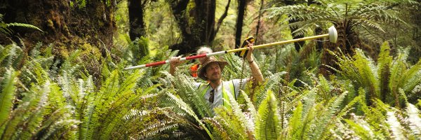
With we aim to uncover global tree mortality dynamics with satellite data. We use drone data as a reference. The coverage is growing rapidly but is still sparse in Africa and Asia. Join the initiative if you have drone RGB orthoimages of any forest :-).
1
9
24
RT @ClemensMosig: Checkout our preprint: - An Open-Access and Interactive Database for Centimeter-Scale Aerial Imag….
0
55
0
10/10: Want to find out more on the challenges and opportunities for #biodiversity or #ecosystem monitoring?. Find a blog post here: or read the full paper here: We are happy for collaborations along these research avenues!.

communities.springernature.com
Since the first NASA Earth observation missions, biophysical vegetation properties such as biomass and chlorophyll content have been monitored using satellites – however, often with significant...
0
0
4
9/10: The variation in leaf angles may not just be a challenge but also opportunity: Since leaf angles are linked to environmental factors, the imprint of leaf angles on reflectance may provide a feature for tracking plant responses to environmental changes or climate extremes.
1
0
3
8/10: Moreover, the way that the environment affects leaf angles of course depends on the site conditions and status of a tree and differs among species. Every tree behaves a bit different and so is the confounding effect of leaf angles on vegetation indices.

1
0
2
7/10: The effect of leaf angles on vegetation indices is not random but correlates with environmental variables. Thus, a pigment or greenness change indicated by a vegetation index may just result from a short time drooping or wilting of leaves.

1
0
2
6/10: Are vegetation indices robust to leaf angle changes? Of course … it depends. In general, we found that more simple indices are more robust (e.g. NDVI) over more complex indices (e.g. kNDVI, EVI). Also some bands (e.g. red-edge) can enhance the robustness (e.g. for MTCI).

1
0
2
5/10: Based on this, we calculated 124 vegetation indices that are frequently used in vegetation assessments (this was only possible with the amazing Spyndex-package of @dmlmont:

1
0
2
4/10: Using #AngleCam, we tracked the vertical leaf angle distribution of 10 temperature tree species over an entire vegetation period. The resulting leaf angle distributions were then used to simulate satellite-based vegetation reflectance of the 10 tree species.

1
0
2
3/10: So far, we could not assess the effect of leaf angle dynamics on satellite signals, because we had no efficient way to track the angles over time. Since recently, we can use #AngleCam, a computer vision method to derive leaf angles from videos.
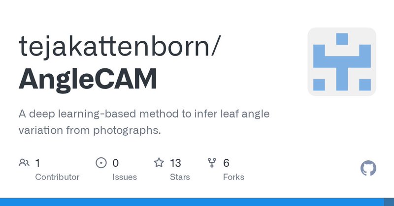
github.com
A deep learning-based method to infer leaf angle variation from photographs. - tejakattenborn/AngleCAM
1
0
3
2/10: We all know that the vertical orientation of leaves can greatly change the reflectance of plants. We also expect this to affect reflectance as measured with Earth observation satellites. So, do leaf angle dynamics confound vegetation indices derived from satellites?

1
0
2