
Dr Robbi Bishop-Taylor 🦋
@SatelliteSci
Followers
8K
Following
14K
Media
1K
Statuses
10K
Posting at 🦋. Earth Observation Scientist at @GeoscienceAus. Using satellites 🛰️ to study the earth 🌍 through space and time
Canberra, Australia
Joined May 2008
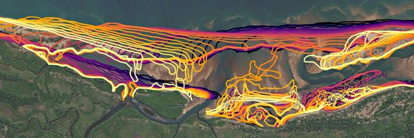
Incredibly excited to announce the release of #DEACoastlines: a brand new @GeoscienceAus dataset providing annual coastlines and detailed coastal change rates along Australia's entire coast from 1988 to now! Explore on the interactive map: https://t.co/BRhjqahHVl
#DigitalEarthAU
22
173
545
😎 Helping you see more than your sunnies ever could - #DigitalEarthAu Tidal Composites reveals beautiful shallow-water coastal sandbanks and mudflats, seagrass beds and coral reefs often hidden from #EO satellites. Explore Australia’s intertidal zones 👉 https://t.co/zfMToe5PxU.
1
1
5

Really excited to officially introduce these new #TidalComposites at the opening session of the @AusYCSEC Young Coastal Scientists & Engineers conference, happening now in Melbourne and online! #AusYCSEC2025

😎 Helping you see more than your sunnies ever could - #DigitalEarthAu Tidal Composites reveals beautiful shallow-water coastal sandbanks and mudflats, seagrass beds and coral reefs often hidden from #EO satellites. Explore Australia’s intertidal zones 👉 https://t.co/zfMToe5PxU.
0
0
4
I'm giving a talk on Thurs about our work to improve tide modelling across Australia's remote and challenging coastlines. I'll also be around the @GeoscienceAus booth if anyone wants to drop by and nerd out on coastal satellite remote sensing! https://t.co/hMChyoVMBC
0
0
0
Wonderful to be at #IGARSS2025 in Brisbane! 🛰️ Hopefully a nice Take 2 from my first IGARSS in Pasedena, CA where I spent half of the conference locked up in COVID hotel quarantine!
2
0
7

Chevron’s ApEX combines AI with decades of expertise to accelerate smarter, confident exploration – and help transform how our oil and gas is discovered.
6
2
15
Excited to share a new paper in the Journal of #OpenSource Software: "eo-tides: Tide modelling tools for large-scale satellite Earth observation analysis" 🌊🛰️ A new Python package designed to help combine satellite data with ocean tide modelling! https://t.co/0TYU8EKV33
1
4
16
Documentation: https://t.co/iwTwoNuPMA Github repo:

github.com
Tide modelling tools for large-scale satellite Earth observation analysis - GeoscienceAustralia/eo-tides
0
0
3
Excited to share a new paper in the Journal of #OpenSource Software: "eo-tides: Tide modelling tools for large-scale satellite Earth observation analysis" 🌊🛰️ A new Python package designed to help combine satellite data with ocean tide modelling! https://t.co/0TYU8EKV33
1
4
16
💕 Love #EarthObservation data? We sure do! 🌏 Digital Earth Australia (DEA) terrestrial and coastal products’ 2024 data are here! 🛰️ #DigitalEarthAu provides nearly 40 years of #EO data, allowing us to see how our landscapes change over time 👉 https://t.co/RJkwG27yRw.
1
2
11

Lenders can more easily work with state and local agencies to find grants and programs that may help borrowers afford a home thanks to our streamlined resources. Learn how.
0
4
46
#DYK❓ #CopernicusMarine provides vector data to visualise the magnitude & direction of marine phenomena, such as: 〰️ Ocean currents 🧊 Sea ice velocity 🌬️ Winds 🔽 #Dataviz showing the wind speed of Hurricane #Milton 🌀 just before landfall in #Florida 🇺🇸 Explore the data:
0
14
33
Our Principal Advisor Maritime Mark Alcock has been awarded a Public Service Medal (PSM) for his service to the community through international leadership in maritime affairs. Congratulations Mark! Thank you for your contribution to Australia's maritime 👉 https://t.co/EcIhcqdqtT
0
1
3
👀 Utilising publicly available geochronology & mineral deposit datasets we’ve developed 3 video animations illustrating 3.5 billion years of geological history of Australia’s magmatism (ages of igneous rocks) & mineralisation. 👉 ▶️ Australian magmatism in less than 2 minutes!
1
3
13
🛰️❄️We're bringing more benefits from Space through our new #DigitalEarthAntarctica initiative, by supporting research, #environmentalsustainability & decision making, through open access, high quality #Antarctic #EarthObservation data 👉 https://t.co/wPhA4BKKSZ.
#AntarcticaDay
0
5
8

#Upwelling is an ocean process in which winds push warm surface water aside, allowing cooler, nutrient-rich water to rise to the surface 🌊 🔽 Wind direction🌬️, SST🌡️, and chlorophyll-a levels🌱on the coast of #California 🇺🇸 visualised using #CopernicusMarine data
1
10
30

Have you ever wondered how to cite #Landsat data? If so, Landsat data citations can be found at the top of each of the data and science product pages. Those pages can be linked to from the Landsat Collection 2 page found here: https://t.co/ud4Zgb6sH3
#OpenData #DataCitation
0
48
172
Read about the latest improvement to https://t.co/sNVU1DIXuJ with Dask: https://t.co/EAkjYHQxZe Thanks to Patrick Hoefler of @CoiledHQ for the great work here!

xarray.dev
Recent dask improvements make GroupBy.map a lot better!
1
7
32
Has been a huge influx of awesome #EarthObservation and #RemoteSensing people to 🦋 recently - if anyone has been waiting to make the jump, here's a starter pack of over 100 accounts! (link below)
3
5
36

Gift cards are boring. Wine is forgettable. Give them USDA Prime steaks — delivered right to their door. 8 FREE Steak Burgers + FREE shipping ($145 value) with code SANTA149 Orders $149+ qualify →
5
9
77
To use the functionality: 1) Load the "Sea, ocean and coast > DEA Intertidal > DEA Intertidal (Sentinel-2, Landsat)" layer into the map 2) Follow this guide to calculate a difference map using your choice of years!
0
0
0
In the @TerriaJS map above: 🔴 = pixels losing sediment between 2017-2022 🔵 = pixels gaining sediment between 2017-2022
1
0
1
Happy #GISDay! A nice opportunity to share a powerful coastal monitoring tool available on our #opensource @GeoscienceAus #DigitalEarthAU Maps platform: easily compare intertidal elevation data over time to map 3D coastal change across Australia!🌊 🗺️Map: https://t.co/oWxpFDzkcT
1
2
10