

PixElement
@PixElementTech
Followers
28
Following
98
Media
28
Statuses
66
PixElement's patented algorithms convert aerial images from drones, planes, or satellites into precise 3D models.
Columbus, Ohio
Joined May 2024
Edit orthos directly in your browser. Remove vehicles, shadows, or other unwanted features with PixElement’s new Orthoimage Editing Tool. No external software needed. #Photogrammetry #GIS #PixElement #MappingTools #OrthoimageEditing.
pixelement.com
If you’ve ever flown over a metal rooftop or body of water, you might’ve noticed strange streaks, color artifacts, or even missing pixels in your orthophoto…
0
0
1
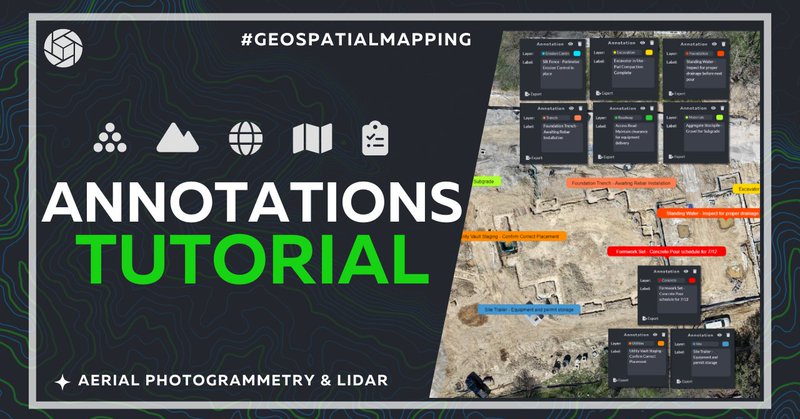
New in PixElement: Add annotations directly to your 2D/3D scenes. Label features, set elevations, and export to various formats. Clarity + collaboration built in. 🔗 #GISWorkflows #3DMapping #GeospatialTools #Photogrammetry.
pixelement.com
In this article, we will walk you through how to use the new Add Annotation tool. Please see the corresponding video tutorial below.
0
0
1
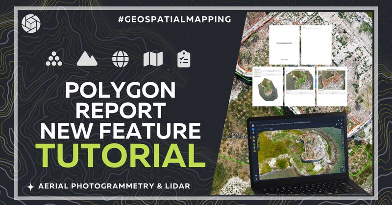
New at PixElement: export your polygon measurements as clean, shareable PDFs. Area, perimeter, coordinates, map previews — all in one report. #DroneMapping #Surveying #Photogrammetry #PixElement.
pixelement.com
Our latest update to PixElement makes it easier than ever to document and share your polygon data with a simple, exportable PDF report…
0
1
2
PixElement 2.4.1 - Now Deployed. This update focuses on stability, performance, and expanded reporting options, built to support high-demand mapping workflows from field to finish. #Photogrammetry #Geospatial #SurveyTech #PixElement #3DMapping #AerialSurvey #Update

0
0
1
Happy 4th of July from the PixElement team 🇺🇸.Today we honor the courage behind our independence, and those who continue to defend it. We build geospatial tools for the mission. We build for you. #4thOfJuly #MissionReady #DefenseMapping #BlueUAS #MadeInUSA

0
1
2
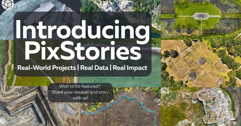
Photogrammetry isn’t just data, it’s documentation, storytelling, and insight. #PixStories is a new series on how users apply PixElement in the field. 📖 Read more: 📤 Got a project? Submit it via the blog. #PixElement #PixStories #DroneMapping.
pixelement.com
At PixElement, we’re continuously inspired by the diverse ways our users apply aerial photogrammetry to solve real-world challenges, whether it’s mapping a remote construction site, documenting...
0
1
2
New in PixElement: denser point clouds, bare earth extraction from LiDAR, better processing feedback, and more. Built for real-world mapping workflows, on both cloud and desktop. Read the full breakdown:. #Photogrammetry #Geospatial #LiDAR #Software.
pixelement.com
PixElement’s latest update introduces a set of practical tools and performance improvements aimed at making your mapping workflows more efficient, accurate, and user-friendly…
0
1
1
🆕 Now live in PixElement Cloud: the Translator Tool 🌍.Edit translations right inside the app—no more file swapping. Ideal for quick fixes or full language updates. #PixElement #Localization #Photogrammetry #Translation #Tool #GeospatialTech.
pixelement.com
In this article, we will walk you through how to use the new Edit Translations Tool, designed to expedite translation updates directly inside the app, without having to send files back and forth....
0
0
1
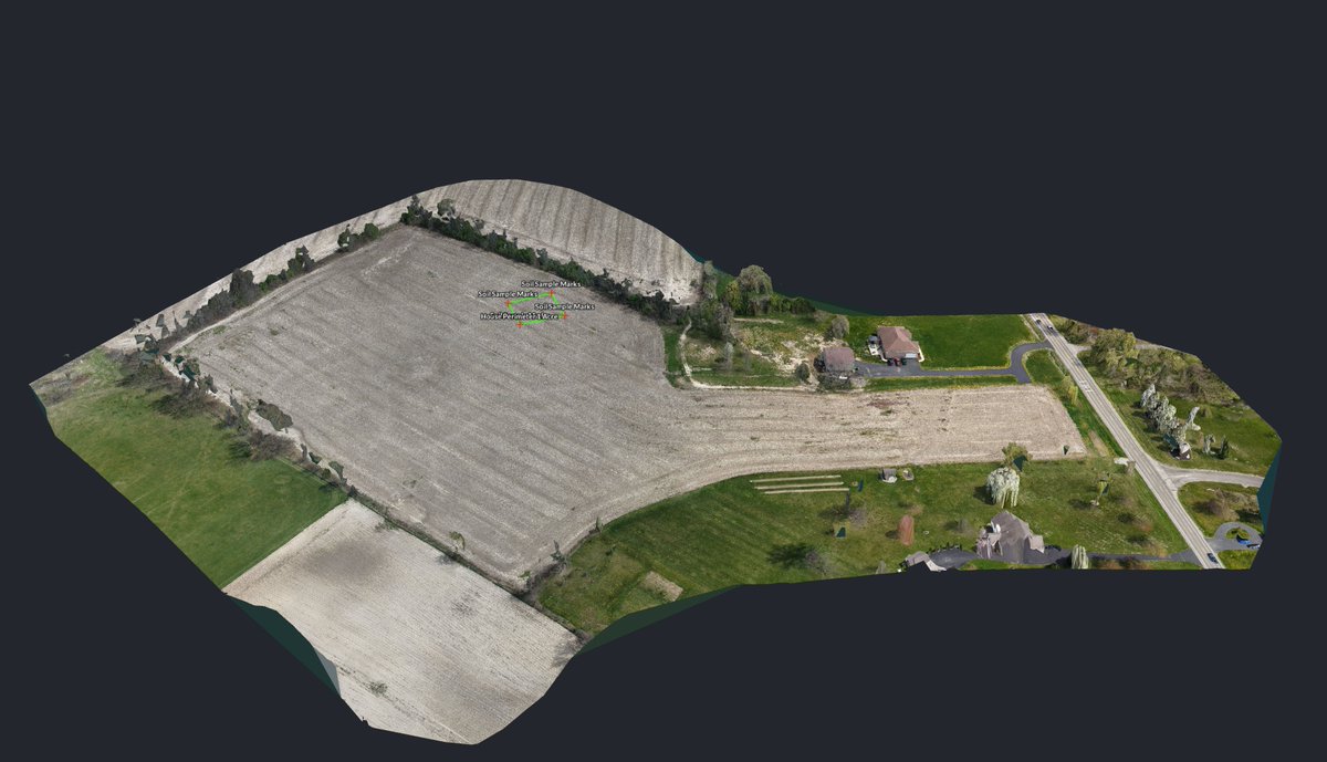
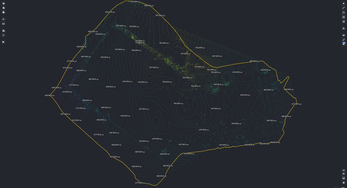
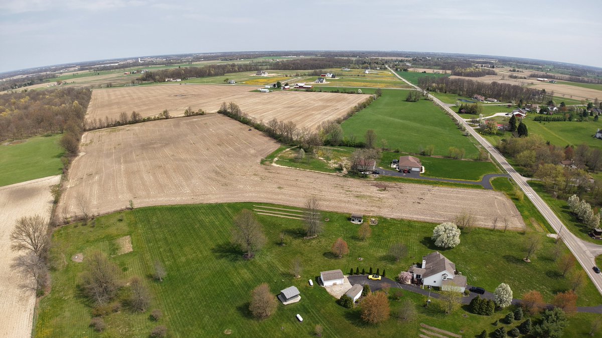
From field to foundation 🏡📍.We used PixElement to map this future homesite in Marysville, OH:.✅ Orthomosaic.✅ Elevation contours.✅ Soil sample & house layout overlay.Smarter planning starts with better data. #DroneMapping #SitePlanning #PixElement
0
0
2
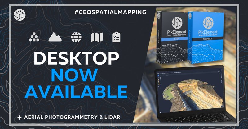
The PixElement desktop version is here—giving you full local processing power for both imagery & LiDAR. Explore our Basic & Advanced packages and see which workflow fits you best. #Photogrammetry #LiDARProcessing #DroneMapping #Surveying #GeospatialTools.
pixelement.com
Today, we are excited to walk you through the PixElement desktop packages available to you, designed to bring advanced aerial photogrammetry tools directly to your desktop.
0
0
0
Our new #VolumeReport tool makes it easy to export a PDF summary of your measured volumes, including cut & fill calculations, surface areas, and project metadata. #AerialPhotogrammetry #PixElement #StockpileManagement #Surveying.
pixelement.com
In this article, we introduce a new feature in PixElement, the Volume Report tool, which allows you to export a concise PDF report of all of the volumes created in the canvas tab. This report...
0
0
1
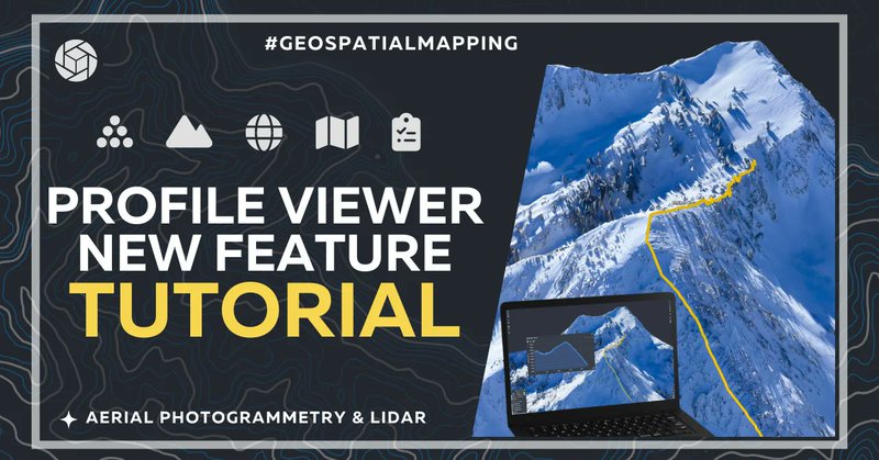
Analyze elevation & grading changes with precision—perfect for water flow management, construction planning, & terrain assessment with Profile Viewer. #PixElement #Surveying #DroneMapping #ElevationAnalysis #3DMapping #CivilEngineering #LandSurveying.
pixelement.com
We’re excited to announce the release of Profile Viewer, a powerful new tool in PixElement’s Survey Canvas designed to help users with elevation analysis and grading workflows.
0
0
1
Oblique & orbit imagery are key to accurate #3D reconstructions—especially for vertical structures. Refine your #photogrammetry workflow with best practices in our latest article. #3DModeling #DroneMapping #ObliqueImagery #BestPractices #Drones.
pixelement.com
In this article, we will be looking at 3D modeling with aerial photogrammetry using oblique and orbit imagery.
0
1
1
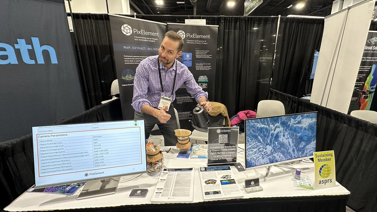
☕️ We are grinding at GeoWeek! ☕️. Stop by the PixElement booth (#1043) for a free cup of coffee and a chat about aerial photogrammetry. A special thanks to Pablo Fuentes at Makepath for modeling. #GeoWeek #PixElement #Aerialphotogrammetry #Denver
0
0
1
PixElement CEO Ben Vander Jagt spoke at the #ASPRS Eastern Great Lakes Region Meeting, sharing insights on integrating LiDAR and photogrammetry for small UAS. Learn how PixElement tackles alignment, calibration, and sensor fusion for accurate 3D models.

pixelement.com
On October 15, 2024, Ben Vander Jagt, founder and CEO of PixElement, delivered an insightful presentation at the ASPRS Eastern Great Lakes Region Annual Meeting, hosted by the University of Toledo….
0
1
2
Refine your #photogrammetry with PixElement's new Edit Clipping Bounds tool! Crop datasets to focus on what matters—faster processing, cleaner models, sharper deliverables. Perfect for construction, surveying & more.#pixelement #aerialmapping #uas #drones.
pixelement.com
We’re excited to introduce a powerful new tool in PixElement - the Edit Clipping Bounds feature…
0
1
2
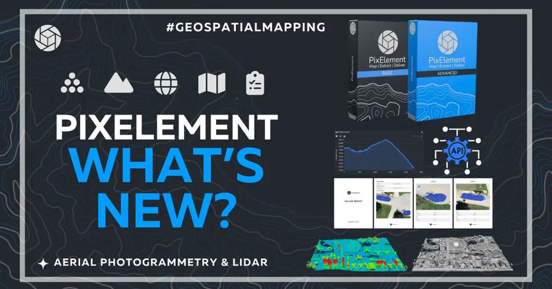
🚀 What's New with PixElement?. New This Year:.- Desktop Version Is Here!.- LiDAR+Imagery Integration.- Enterprise API .- Expanded tools. 👉 Read the full update here: [. #AerialPhotogrammetry #PixElement #Drones #Mapping #Innovation #uas #drones #startups.
pixelement.com
We’re thrilled to share what’s new and what’s coming your way in the world of aerial photogrammetry….
0
1
2
Our latest update brings Profile Viewer, Volume Reports, and Canvas Snapping Tools—enhancing workflows with greater efficiency, accuracy, and adaptability for aerial photogrammetry. #NewFeatures #AerialPhotogrammetry #Geospatial #Mapping #drones #UAS.
pixelement.com
Introducing Profile Viewer, Volume Reports, and Snapping Polylines to Mesh: Streamlining Precision with PixElement…
0
2
2
Learn how to optimize overlap, adjust for terrain, and plan flights for industries like construction, mining, and surveying. #ImageryOverlap #AerialPhotogrammetry #3DModeling #Surveying #Drones #UAS #PrecisionMapping #Geospatial #TechInnovation.

pixelement.com
In aerial photogrammetry, imagery overlap is an essential principle to master to obtain the best results from your dataset.
0
2
1
Dive into the core of your mapping projects! Learn how to use the Analyzer tab in PixElement to view sparse point clouds, edit reference points, and refine your deliverables. #PixElement #annotations #analysis #tutorial #GCPs #sparsepointcloud.
pixelement.com
The Analyzer tab is used for viewing the sparse point cloud, editing your reference points and viewing the photos taken by the aerial system…
0
1
2