

Orion Terrametrics
@OrionGeospatial
Followers
297
Following
138
Media
34
Statuses
119
Welcome to Orion Terrametrics Solutions We offer Precision geospatial services: Engineering Surveying | Cadastral/Boundary Drone LiDAR & Aerial Mapping | GIS
Nairobi, Kenya
Joined February 2025
Topographic Mapping with Aerial LiDAR This week we delivered a high-accuracy topo survey combining 30% fieldwork + 70% desktop LiDAR/photogrammetry processing. Contours, DTM, DSM & full feature extraction — all done with precision.
0
2
8

🗺️ Python Mapping Library Spotlight — AnyMap Working across Mapbox, MapLibre, OpenLayers, KeplerGL, DeckGL, Cesium or Leaflet normally means juggling different APIs. AnyMap removes that friction. A Python package for building interactive web maps in Jupyter — with
3
31
142
Across Africa, critical geospatial data is still locked in silos—hard to find, fragmented, and difficult to use for meaningful analysis. The Orion Spatial Data Hub removes these barriers.
1
7
9
Our platform provides a unified, open-standard infrastructure where spatial intelligence becomes accessible, actionable, and collaborative for governments, researchers, and organizations across the continent. 👉 Explore the Hub: https://t.co/8gZtMrd0SG
0
2
5
Our platform provides a unified, open-standard infrastructure where spatial intelligence becomes accessible, actionable, and collaborative for governments, researchers, and organizations across the continent. 👉 Explore the Hub: https://t.co/8gZtMrd0SG
0
2
5
Across Africa, critical geospatial data is still locked in silos—hard to find, fragmented, and difficult to use for meaningful analysis. The Orion Spatial Data Hub removes these barriers.
1
7
9

@silvesterw55524 Good job from @OrionGeospatial . The dream team from TUK led by @mutethia_karuma senior
1
1
2
Yesterday, @OrionGeospatial pitched a tent at our alma mater, the Technical University of Kenya (@TU_Kenya), to celebrate GIS Day in a special way. Our CEO, @GodieMurithi, delivered an electrifying talk on the power of open-source GIS, while our survey division exhibited and ran
2
8
34
@Elbito_Guzzman @OrionGeospatial It was a fruitful engagement with learners and fellow professionals at TUK.
0
3
5
0
1
3

@mutethia_karuma @OrionGeospatial @TU_Kenya @GodieMurithi Glad to have passed by your booth. Excellent work by @OrionGeospatial showcasing practical open source GIS and survey workflows. Always great seeing teams advancing geospatial capacity in our institutions. Looking forward to future collaborations.
0
1
1
@silvesterw55524 @OrionGeospatial @mutethia_karuma @MugohBrian5427 Thank you for visiting our booth and interacting with our team. We were happy to see and enagage with you as well.
0
1
2

Appreciation to @OrionGeospatial for an impactful GIS Day at TUK. The hands-on sessions with the Total Station, RTK, levels, and the insights on digital photogrammetry were truly valuable. Thanks for the great learning experience.@mutethia_karuma,@GodieMurithi,@MugohBrian5427

Yesterday, @OrionGeospatial pitched a tent at our alma mater, the Technical University of Kenya (@TU_Kenya), to celebrate GIS Day in a special way. Our CEO, @GodieMurithi, delivered an electrifying talk on the power of open-source GIS, while our survey division exhibited and ran
1
7
19
QGIS Model Designer: Build Automated Geospatial Workflows Without Coding The QGIS Model Designer is a powerful tool that lets you build complex geoprocessing workflows using a simple visual interface. Instead of running tools one by one, you can chain multiple GIS processes into
3
36
162
Elevate Your GIS Skills with PostgreSQL + #PostGIS: The Professional’s Vector Data Backbone If you’re still managing your vector GIS data through scattered shapefiles, ad-hoc folders, or aging file geodatabases… it’s time for a serious upgrade. Modern GIS work demands
2
32
127
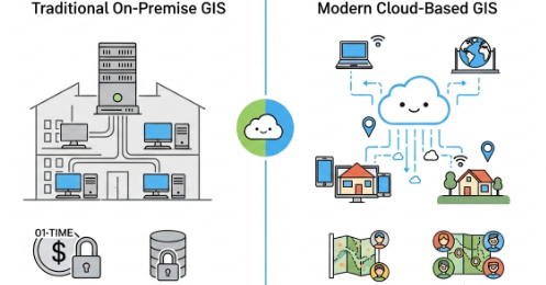
Cloud based GIS provides infrastructure for handling massive datasets, real-time collaboration across teams, and cost-effective OpEx models—eliminating hardware constraints and enabling global accessibility. https://t.co/9NIJeYRXp1
orionterrametrics.co.ke
Cloud-based GIS solutions, moves the core components of traditional GIS software, data storage, and processing power from local servers to a distributed network of remote servers hosted on the...
0
1
1
🌍 Every smart map starts with a strong GIS database. At Orion Terrametrics, we help organizations build scalable systems — from simple GeoPackages to enterprise-grade PostGIS solutions. Turn your spatial data into actionable insight. 🌐 #OrionTerrametrics #GIS #Geospatial
0
0
5

Surveyors and Engineers on my TL; is it possible to change the background of an image on Autocad. Case in point, changing the sky in the image to a teal background?
5
1
9
The rains are here. We thank God for the rains. Fieldwork is going to be nightmarish. Most siteworks are going to pause momentarily. Limited earthworks, Developers scared of the rain, Christmas around the corner, increasingly punitive investment climate in our country right now,
2
6
30