
NatGeoMaps
@NatGeoMaps
Followers
36K
Following
317
Media
2K
Statuses
4K
Since 1915, National Geographic Maps has been responsible for illustrating the world around us through the art and science of mapmaking.
Washington, DC | Evergreen, CO
Joined April 2009
Designed for travelers and printed on waterproof and tear-resistant paper, our new series of folded reference maps for the continents is based on the classic political and physical maps from our atlases, with country flags and facts on the back side. https://t.co/3UGdWV7Qyz
12
11
54
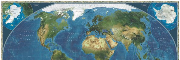
The September 2013 issue of @NatGeoMag published these maps showing the world as it is now, but with all the ice on land melted and drained into the sea, raising it 216 feet and creating new shorelines for our continents and inland seas. https://t.co/c1778F7Zj4
#sealevelrise #map
5
27
120
Cyclones usually form over warm ocean water in the tropics and subtropics. Lightning flashes are more likely to occur over land than water, and most often in the tropics. From the @NatGeoBooks Family Reference Atlas https://t.co/MouYklFl0H
#maps #hurricanes #cyclones #lightning
4
9
31
Published in January 1993, this illustrated map shows North America as it was 74 million years ago when Tyrannosaurs, Ceratopsians, and Sauropods roamed the region. #dinosaurs #dinos #paleontology #illustration #map #cartography #natgeo Get the poster: https://t.co/Vi37R3KeOK
2
49
256
Igneous and metamorphic rocks make up 95 percent of the crust’s volume. Sedimentary rocks, although only a small percentage of the total, are the type most commonly found exposed on the surface. From the @NatGeoBooks Family Reference Atlas https://t.co/MouYklFl0H
#rocks #geology
0
8
26
After almost four centuries of peace and prosperity under Rome, Britain faced an onslaught from pagan aggressors. Only Ireland was spared. Historians dispute their intent but agree on their identity—the Angles, the Saxons, and the Jutes—and that they came to stay. @NatGeoBooks
4
6
52
The first human settlers of the islands of New Zealand were the Maori from Polynesia. The names on our New Zealand map reflect this history with both English and Maori variants. #NewZealand #Maori #Map #Cartography #MiddleEarth #NatGeo Get the map: https://t.co/8y5yzdJAl9
0
9
55

Summer is the perfect time to go stargazing! 🌌💫 Illustrated with luminous photographs and informative graphics, this expansive book is the ultimate guide for everyone discovering the wonders of the night sky. Prepare to be dazzled: https://t.co/3U67TD7Vte
1
4
14
Almost a third of all US lands and waters are now protected areas, sheltering many of the nation's remaining wild spaces. Over a century and a half, these natural landscapes have been set aside to prevent their conversion into other uses, such as urban development or agriculture.
1
6
30
Hidden canyons and high meadows distinguish the Gila Wilderness, land once inhabited by the Apache. In 1924, the US Forest Service designated it as the world’s first “wilderness area,” where people could visit but must leave no permanent mark. From the June issue of @NatGeoMag
0
4
23

This beautiful map, created by Riley Champine, outlines the physical features of Serengeti, the boundaries of many protected areas, and the migration of over a million wildebeests! https://t.co/AEtU8tpeFL
1
11
44
By the end of the 3rd millennium BCE, Semitic tribes had settled on the coast of present-day Lebanon and Syria, making the cities of Tyre, Sidon, and Byblos. The Greeks named them Phoenicians, from the word “phoinix,” or purple, due to their purple cloaks. https://t.co/wxh74xbXan
0
22
85
Published in September 2007 as a @NatGeoMag page map in the article "Struggle for the Soul of Pakistan," this map illustrated the geographic divide that contributes to the country's sociocultural and political divisions. https://t.co/FHaTKIsbro
#pakistan #geography #history
0
14
67
Rounding out the weekend with the Continental Divide Trail to finish the "Triple Crown of Hiking" series, available as a poster bundle for the long distance hikers in your life. Triple Crown boxed set: https://t.co/IS5Dlu4C3m
#NationalTrailsDay #AT #PCT #CDT #TripleCrownofHiking
0
5
35
Today is National Trails Day in the US. Long distance trails like the Pacific Crest Trail represent the ultimate manifestation of trail collaboration across local, state and national scales. PCT poster: https://t.co/HFjWeNhCDI
#NationalTrailsDay #PacificCrestTrail @americanhiking
3
32
129
The first Saturday in June is National Trails Day. Long distance trails like the Appalachian Trail represent the ultimate manifestation of trail collaboration across local, state, and national scales. AT poster: https://t.co/cyCqVvtRXf
#NationalTrailsDay #AppalachianTrail
2
11
66
The Ukraine conflict has origins in the Cold War and the imperial contests before it, and is drawing new global divisions after decades of relative stability. Get the map in the June @NatGeoMag. https://t.co/cAWbzMnWxE
#ukraine #war #russia #map #cartography #natgeo #ukrainemap
0
38
108
For centuries, competing empires have fought over the fertile plains and strategic waterways that make up modern #Ukraine. Independent since the 1991 breakup of the Soviet Union, it has been trying to reclaim territory seized by Russia in 2014. Get the map in the June @NatGeoMag.
0
22
67
Kris Tompkins leads the visionary effort that she and her late husband began in the 90's to buy millions of acres in Chile and Argentina, then donate them to create new parks. @NatGeoTV documentary Wild Life chronicles their effort. https://t.co/Uj5TPR6HXQ
https://t.co/4zvmnUMw5R
2
4
24
In the Congo Basin tens of millions of animals are hunted each year, some illegally in protected areas. Wild meat is a food and income source for communities that trade along routes connecting forests with villages and cities. Read the story (subscribers) https://t.co/SnczSQtEVi
0
4
8