
NWS Omaha
@NWSOmaha
Followers
73,424
Following
308
Media
25,175
Statuses
44,902
Official Twitter account for the National Weather Service in Omaha/Valley Nebraska. Details:
Valley, NE
Joined June 2012
Don't wanna be here?
Send us removal request.
Explore trending content on Musk Viewer
Amethi
• 151768 Tweets
Knicks
• 141113 Tweets
राहुल गांधी
• 125929 Tweets
Sixers
• 71881 Tweets
Brunson
• 69048 Tweets
Pacers
• 62764 Tweets
憲法記念日
• 62541 Tweets
Embiid
• 57203 Tweets
Philly
• 55693 Tweets
#Raebareli
• 54220 Tweets
Dua Lipa
• 36098 Tweets
Maxey
• 31451 Tweets
Bruins
• 27486 Tweets
FREENBECKY IS OUR HOME
• 27304 Tweets
76ers
• 25525 Tweets
Rony
• 25409 Tweets
連休初日
• 23768 Tweets
#FattuPappu
• 22705 Tweets
Tobias Harris
• 21326 Tweets
Pachuca
• 21125 Tweets
स्मृति ईरानी
• 20137 Tweets
Josh Hart
• 20084 Tweets
ゴジラ-1.0
• 19699 Tweets
पूर्व मुख्यमंत्री
• 19271 Tweets
Smriti Irani
• 18964 Tweets
Hield
• 16949 Tweets
Hayırlı Cumalar
• 16903 Tweets
Pumas
• 15360 Tweets
チャレンジクルー
• 15174 Tweets
किशोरी लाल शर्मा
• 14981 Tweets
KerenTIMNASKU STYdanERICK
• 12445 Tweets
TetapSMANGAT GarudaMUDAKU
• 12067 Tweets
Wayanad
• 11775 Tweets
Last Seen Profiles


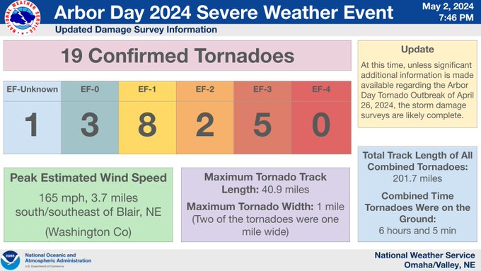
Update Regarding the Arbor Day Tornado Outbreak
At this time, unless significant additional information is made available regarding the Arbor Day Tornado Outbreak of April 26, 2024, the storm damage surveys are likely complete.
For more information:
6
87
285
For those in eastern Nebraska & western Iowa... sunshine is on the way! ☀️
4
8
97
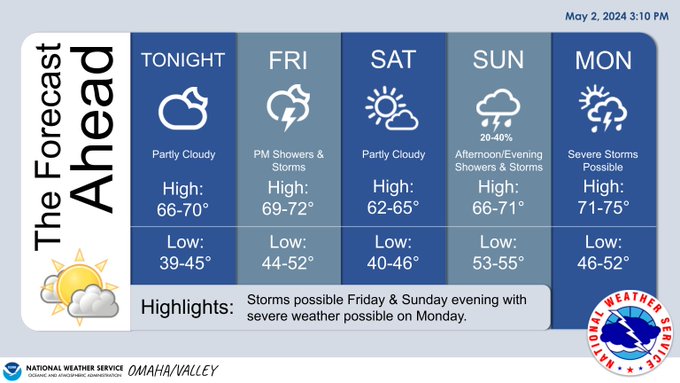
5-Day Forecast ☀️🌧️
A few breaks in the clouds may give us a peek at some sunshine this evening. High temperatures will remain in the upper 60s and low 70s through the weekend.
Showers and thunderstorms return Friday and Sunday night. Severe storms are possible on Monday.
1
2
24
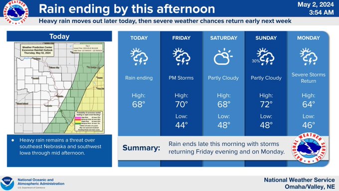
Showers and storms will continue this morning primarily affecting southeast Nebraska and western Iowa. Heavy rainfall and gusty winds are the primary threats with these storms. Severe weather chances return by Monday of next week.
3
3
28
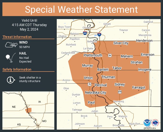
A special weather statement has been issued for Nebraska City NE, Plattsmouth NE and Glenwood IA until 4:15 AM CDT
1
3
25
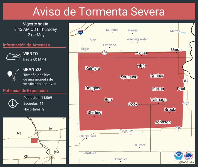
Aviso de Tormenta Severa incluye Syracuse NE, Palmyra NE, Sterling NE hasta las 3:45 AM CDT
0
0
1
Severe Thunderstorm Warning including Syracuse NE, Palmyra NE and Sterling NE until 3:45 AM CDT

0
0
4
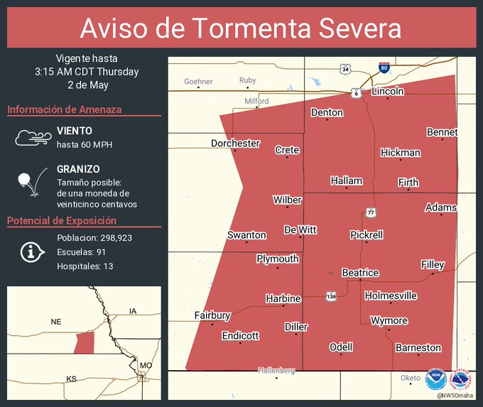
Aviso de Tormenta Severa incluye Lincoln NE, Beatrice NE, Crete NE hasta las 3:15 AM CDT
0
0
4
Severe Thunderstorm Warning including Lincoln NE, Beatrice NE and Crete NE until 3:15 AM CDT

1
4
33
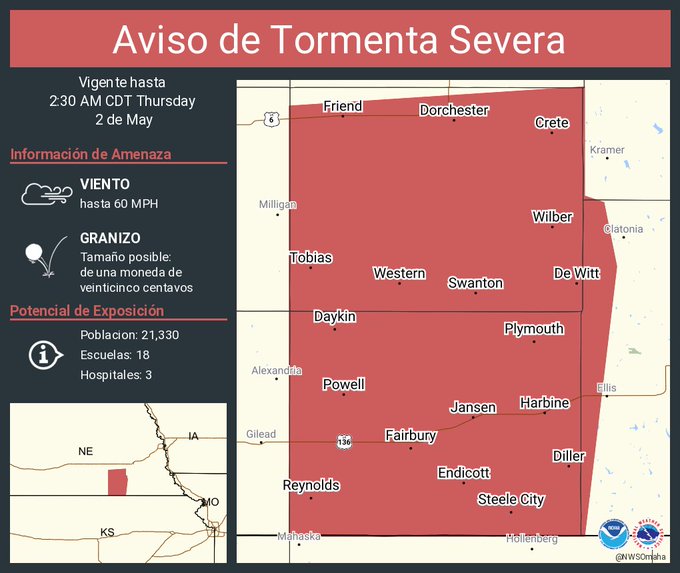
Aviso de Tormenta Severa incluye Crete NE, Fairbury NE, Wilber NE hasta las 2:30 AM CDT
0
0
3
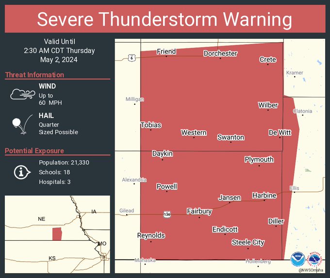
Severe Thunderstorm Warning including Crete NE, Fairbury NE and Wilber NE until 2:30 AM CDT
0
0
9
Vigilancia de Tormenta Severa ha sido emitida para partes de Kansas y Nebraska hasta las 6 AM CDT

2
0
3
A severe thunderstorm watch has been issued for parts of Kansas and Nebraska until 6 AM CDT

5
3
20
Scattered showers and thunderstorms will bring the risk of heavy rain and flooding to much of eastern Nebraska and southwestern Iowa tonight. There is a low end severe risk closer to the Kansas border later this evening, so be weather aware!
2
16
71

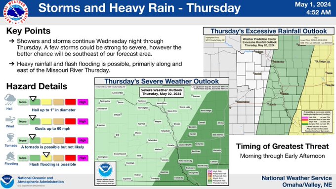
Heavy rain will continue from Wednesday night into Thursday with a chance for flooding and perhaps a few strong to severe storms.
0
6
34
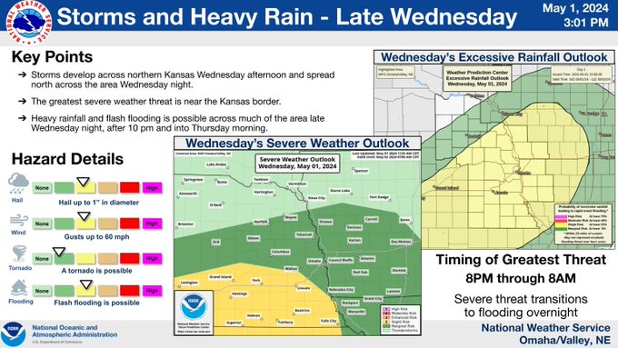
A late round of thunderstorms is expected after 8 pm Wednesday and will continue into early Thursday. Severe storms look to be confined near the Kansas and Nebraska border. Heavy rain will be possible across the entire area.

4
18
58
A late round of thunderstorms is expected after 10 pm Wednesday and will continue into early Thursday. Severe storms look to be confined near the Kansas and Nebraska border. Heavy rain will be possible across the entire area.

4
11
61
A late round of thunderstorms is expected after 10 pm Wednesday and will continue into early Thursday. Severe storms look to be confined near the Kansas and Nebraska border. Heavy rain will be possible across the entire area.
3
13
38
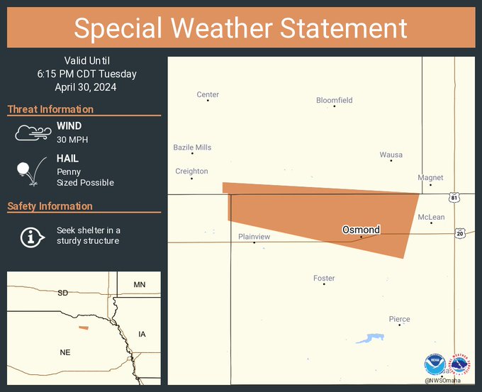
A special weather statement has been issued for Osmond NE until 6:15 PM CDT
0
0
7