
NWS Boise
@NWSBoise
Followers
28K
Following
6K
Media
9K
Statuses
14K
Official X account for the National Weather Service Boise. Details: https://t.co/kwtncnlnle
Boise, Idaho
Joined October 2012

Smoke from fires around the region will drift into our area today into Thursday. The main contributor will be the Cram Fire in north-central Oregon. In our area, most of the smoke should stay aloft, but some will make it to the surface, especially in SE Oregon.
0
3
17
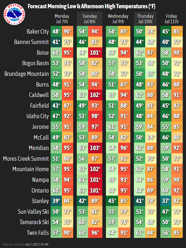
Good morning! Today won't be quite as hot with highs near normal. Winds will be breezy behind a cold front that moved through last night. Most areas will see gusts 20-30 mph this afternoon, but a few spots east of Boise and Ontario to Baker City will see gusts 30-40 mph.


1
2
29
The Cram Fire in Central Oregon took off today, with smoky skies potentially moving into the region tomorrow morning. Luckily, a frontal passage will bring breezy northwest winds and cooler temperatures for much of the area tomorrow, preventing smoke from settling.
1
0
16
Here is your friendly reminder that it is going to be hot these next couple of days. A Heat Advisory remains in effect from 12pm MDT today through 9PM MDT Monday for the Lower Treasure Valley. A dry cold frontal passage Monday night will cool our temps to near normal on Tuesday.


0
3
15
🥵Did somebody say it was July? If so, the temperatures seem to agree warming to 5-10 degrees above normal come Sunday/Monday. A Heat Advisory is in effect from 12pm MDT Sunday until 9pm MDT Monday for the lower Treasure Valley.


0
1
24
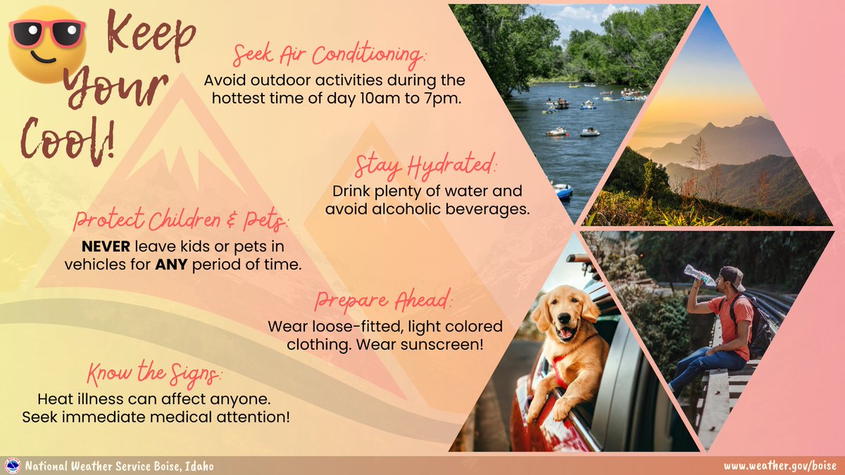
Don't let the heat ruin your weekend! Know how to keep yourself and others safe from heat-related illnesses.
1
1
9
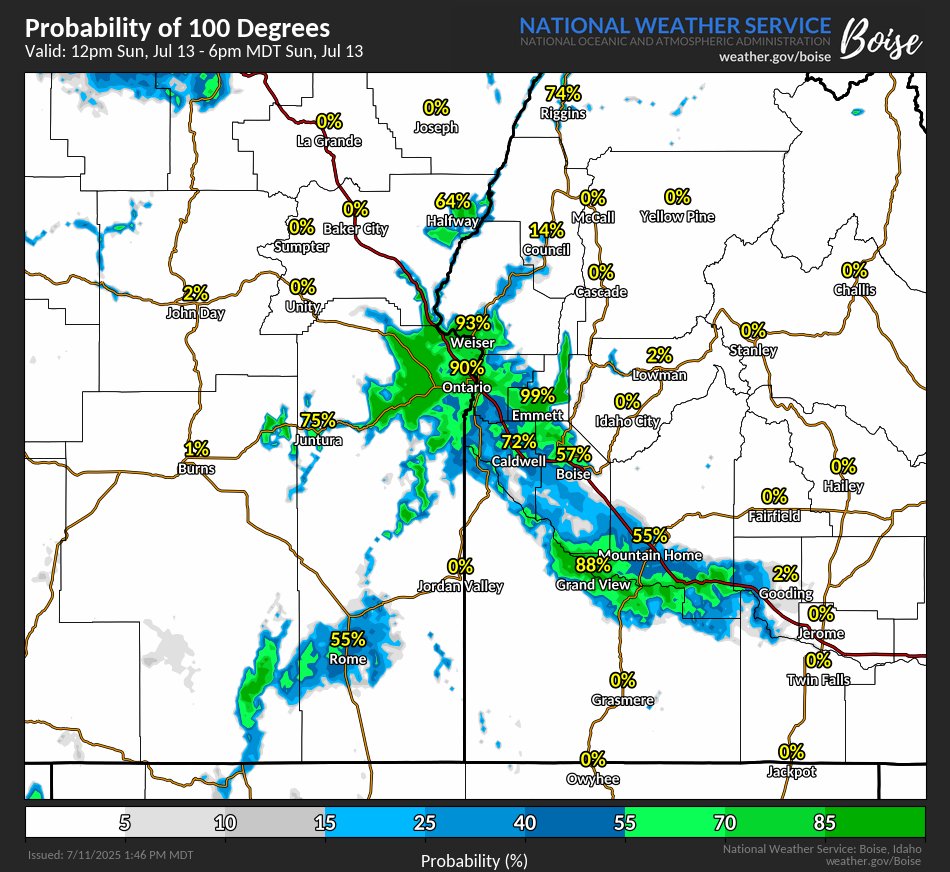
Hotter weather the next few days. This chart shows the percent probability of reaching 100 degrees on Sunday:
1
1
12
Mid-July says hi. Temperatures will start to heat back up after today, rising to around 5-8 degrees above normal for Sunday and Monday.
1
2
14
Surface haze and smoke layers aloft will be drifting around east Oregon and southwest Idaho due to a few wildfires across the region. Here's the latest smoke forecast through Saturday morning.
0
3
17
A powerful downburst near Stage Stop earlier tonight sent winds surging to 68 mph — while Boise, just miles away, was 10 to 20 mph at the same time. 💨. Dry air below the shower/storm = evaporating rain = rapid cooling = sudden blast of wind. Classic microburst setup!
3
8
102
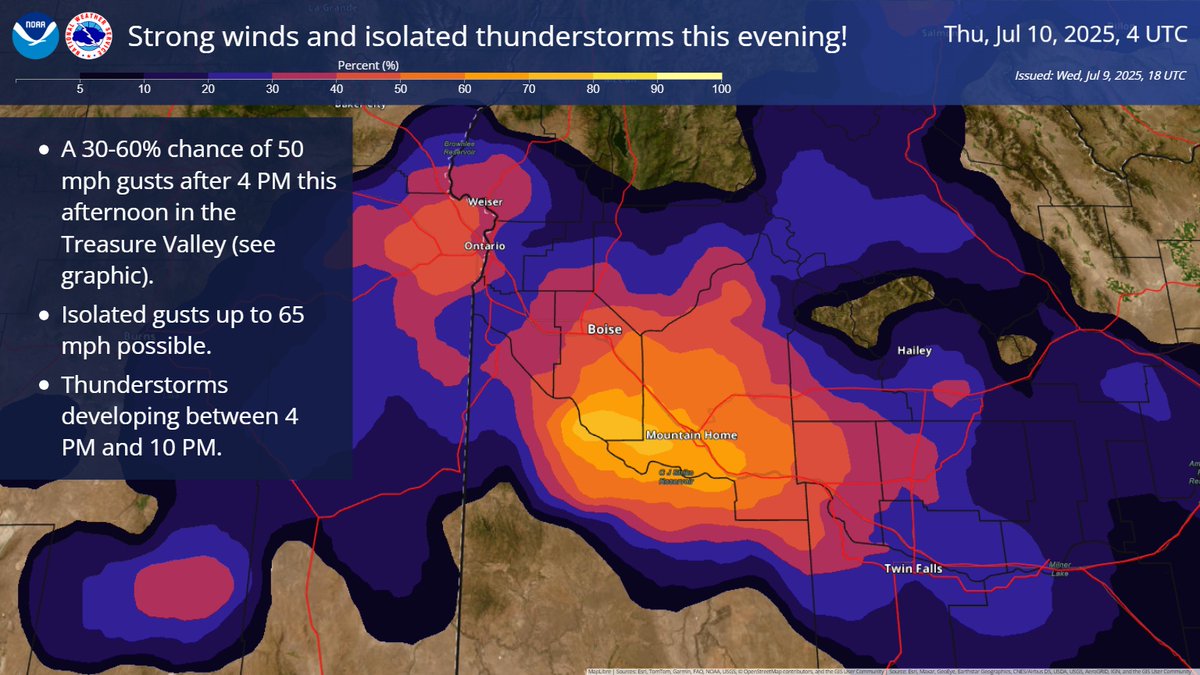
Heads up, Treasure & Western Magic Valleys! 🌬️⛈️. Strong winds are expected this afternoon/evening (4 PM - 10 PM), with gusts of 50-65 mph and areas of blowing dust. See graphic below for the probability of 50 mph gusts. Isolated t-storms are also possible with brief heavy rain
3
9
43
🚨 𝗥𝗘𝗖𝗢𝗥𝗗 𝗔𝗟𝗘𝗥𝗧: Boise hit 104°F today — hottest day of Summer 2025 so far! Ties the daily record set back in 2017. 🔥🌡️.
1
6
42
⛈️Thunderstorms will develop this evening mainly across southeast Oregon and the west-central Idaho mountains. Additional storms will develop Wednesday across much of our area. Lightning, gusty winds 50-60 mph, brief heavy rain, and blowing dust will be possible.
0
3
17
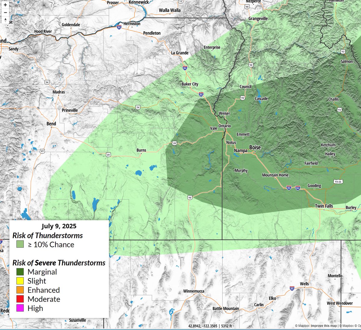
⚡️💨There is a chance (less than 30 percent) of strong to severe thunderstorms producing wind gusts in excess of 50 mph late Wednesday afternoon and evening, especially in the dark green area highlighted in the image below. Patchy blowing dust is also a concern.
0
1
18
☀️Heat Advisory in effect Tuesday for the Treasure Valley as highs climb above 100 degrees. Hot temperatures may cause heat illnesses, especially for the young, elderly, and animals. ⚡️A system will bring a slight (10-20%) chance of thunderstorms late Tuesday into Wednesday.


0
3
12
🌡Very hot temperatures are expected across the region through Tuesday. ⚡️There is also a low chance of showers and thunderstorms Tuesday and Wednesday, accompanied by gusty winds💨. Cooler temperatures return by Thursday!

0
1
8