
Logan Giles
@LoganGilesWx
Followers
4K
Following
56K
Media
16K
Statuses
48K
Climatologist I Fairfield and Salisbury grad I Currently living with CIDP I| Contributor to @thenatsreport
Chevy Chase, MD
Joined September 2013
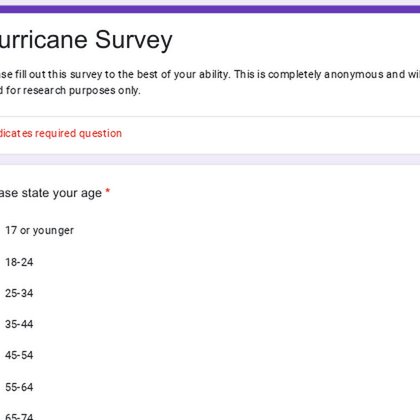
I am accepting answers for a survey that is anonymous and for research purposes only. Please feel free to share this with anyone. https://t.co/zCD3nHFQFz
docs.google.com
Please fill out this survey to the best of your ability. This is completely anonymous and will be used for research purposes only.
0
4
8

Comet C/2025 A6 (Lemmon) ☄️ over Connecticut tonight Single exposure 10 seconds 180mm 2.8 (cropped) Class 5 Bortle skies
5
11
66

Here is a map of Landslide Prone Areas and Historical Landslides in Jamaica. Let us know if you are prepared for Tropical Storm/Hurricane Melissa. If you have any question, see you in the comment section. Contact us: info@monainformatixltd.com #TrackingMelissa #LandSlides
0
150
223
I have released my 2026 Calendar. Presale is available until next week with Black Friday sale, perfect for the holidays. I am excited to create this, the first calendar. Every photo has come within the past year that I have taken https://t.co/dmw3qdqle3
2
3
6
Coldest start of the season for many. Notice the microclimate on the eastern shore of the Chesapeake.
0
0
1
Very concerned about Jamaica, Haiti, and Cuba with #Melissa. Significant hurricane with catastrophic rain, surge, and wind forecasted. These areas are mountainous which raises mudslide potential
1
0
3

Skip the Scroll — Read the Brief. Subscribe to the Nats Report's Morning Briefing. All the latest Washington Nationals headlines, news and more delivered to your inbox!
1
1
0
Bottom line is be more focused on the storm that is likely to hit Wednesday/Thursday next week. Rain will be the primary factor. Of course any system like this will have wind. But late October timing, maybe snow for elevations above 3000'?
0
0
1
Setup is rather simple 1) Eastern US trough 2) #Melissa 3) North Atlantic trough 4) Atlantic ridge Timing of these are critical. As expected, guidance is all over the place at this range. While a landfall is very unlikely, it is too soon to say where this will go
1
0
2
We turn our attention to #Melissa, which has a better chance to head away from the United States, but I am not comfortable with it being too far east. Weird interactions are possible when you have a trough being in close proximity to the hurricane.
1
0
2
Backside of the low is where I could see wintry precipitation. Temperatures are marginal and there is some support. But this would be possible if it is away from the coast most likely. Low level winds would be NNW which would support it. But for now keeping it as a possibility.
1
0
2
Regardless there is potential for several inches of rainfall, due to copious amount of moisture streaming off the Atlantic. This would help the ongoing drought.
1
0
1
Large uncertainty lies where the low will be. Guidance is inconsistent on location, inland runner or coastal. This is very key as not only will it drive the storm, but also what precipitation those in higher elevations see. The uncertainty can be traced to a subtle Alberta ridge
1
0
1
Good agreement low pressure will be somewhere off the Southeast and Mid-Atlantic coast Wednesday/Thursday. This will be driven by the left exit region in a jet streak which promotes cyclogenesis. That will be how our low forms in addition to baroclinicity. Can see cold front here
1
0
1