

Sarah Spivey
@KSATSarahSpivey
Followers
7K
Following
2K
Media
3K
Statuses
5K
Just forecastin’ in my hometown ☀️ | @ksatnews Meteorologist | AMS Certified Broadcast Meteorologist #924 | Momma to Norah 😻
San Antonio, TX
Joined July 2018

Sunday, 7 AM Heavy rain for Uvalde, Edwards, and Real Counties, leading to the risk for flash flooding in these areas until 9:45 a.m. In San Antonio, the flood risk today is lower. We still expect *some* rain, so you should stay alert! DETAILS: https://t.co/t8zYxKubq5


2
6
20
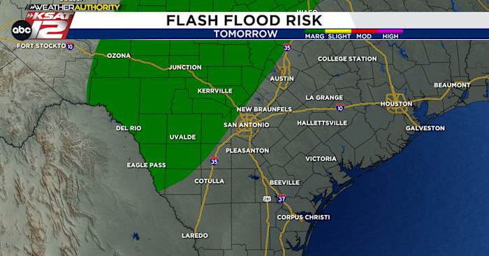
Stay alert for the risk of flash flooding (9/6 & 9/7) • SATURDAY (40%): Some Storms • SUNDAY (70%): Many random showers/storms 4am-7pm • AMOUNT: Random bullseye of 5″ possible *less for most areas* • IMPACT: Flash flooding possible #KSATnews #KSATweather #SATX #SanAntonio
2
6
27
SUNDAY, AUGUST 31 Areas of flash flooding are ongoing around the city of San Antonio. A flash flood warning is in place until 10:15 PM. Use caution and remember TURN AROUND DON’T DROWN. Post pics and vids of what you’re seeing in KSAT Connect #KSATnews #KSATweather #SanAntonio
3
18
98
⚠️ FLOOD WATCH: Flooding is *possible* Sunday & early Labor Day ☔️ HIGHEST RAIN CHANCE: Sunday afternoon through evening (60%) 🇺🇸 LABOR DAY: Lingering morning storms possible (40%) 💧 AMOUNTS: Pockets 1″ to 3″, Bullseye 4″+ ‼️ CONCERNS: Street flooding, rivers/streams rise
1
6
31
🇺🇸 • SATURDAY: HOT! Only spotty rain after 4 pm • SUNDAY EVENING THROUGH LABOR DAY: Highest rain chances • AMOUNTS: Pockets of 1″ to 3″ with any storms • IMPACT: Outdoor activities briefly interrupted • ANY RISKS? Minor street flooding & brief, gusty winds
0
1
16
Summer status quo this weekend with a look ahead to the tropics! 👀🌀 • SATURDAY: Sunny & hot. Near 100° • SUNDAY: Also near 100°, a coastal shower possible • SMALL RAIN CHANCE NEXT WEEK: 20% mainly Monday and Tuesday • TROPICS: Watching the Atlantic next week
1
6
18

😳How severe is our area’s current #drought? Yesterday’s Edwards Aquifer reading of 631.3 was only 5 feet higher compared to the same date from the drought of record in 1955! Please follow Stage 3 watering rules: https://t.co/298Nqsa6r7.
@BillTaylorKENS5

0
5
4
7/26 & 7/27 WEEKEND FORECAST: Spotty downpours, flooding unlikely • RAIN CHANCES: 40% Saturday, 30% Sunday • NOT RAINING ALL DAY: Spotty, and mainly in the afternoons • NO HAIL • FLOODING UNLIKELY: Pockets of 1″ to 2″ possible
3
7
20
‼️ FRIO RIVER WARNING ‼️ (7/14/2025) The Frio expected to reach major flood stage at Concan and near Uvalde. This is forecast to occur at Concan close to 11 AM, and near Uvalde close to 5 PM. If near the Frio, you should seek higher ground and be aware of your surroundings.

2
15
36
SUNDAY, JULY 13 UPDATE 7 AM 👀 FLOOD WATCH: Through Sunday night, Flooding *POSSIBLE* ☔️ AMOUNT: Pockets of 1″ to 3″, Bullseye 8+” ‼️MAIN CONCERN: Streets, creeks, low-water crossings ⚠️ KERR CO.: Volunteers, first responders should stay very alert near Guadalupe
5
10
41

The Guadalupe River is receding and flowing into the Canyon Lake on Saturday morning. Here's a breakdown of the river's levels over July 4 and 5. FORECAST ARTICLE: https://t.co/7518ehbhiT @ksatweather @KSATSarahSpivey
1
52
151
The same low-pressure system that brought deadly flooding July 4th along the Guadalupe River is still spinning above Central Texas and the Texas Hill Country. FORECAST ARTICLE: https://t.co/7518ehbhiT @ksatweather @KSATSarahSpivey
0
7
16
It’s been a devastating day along the Guadalupe, and flooding will continue downstream https://t.co/tGE1eJ0pQk
ksat.com
Less coverage, but flash flooding from pockets of 2″-4″, random bullseye of 5+″ possible
2
9
34

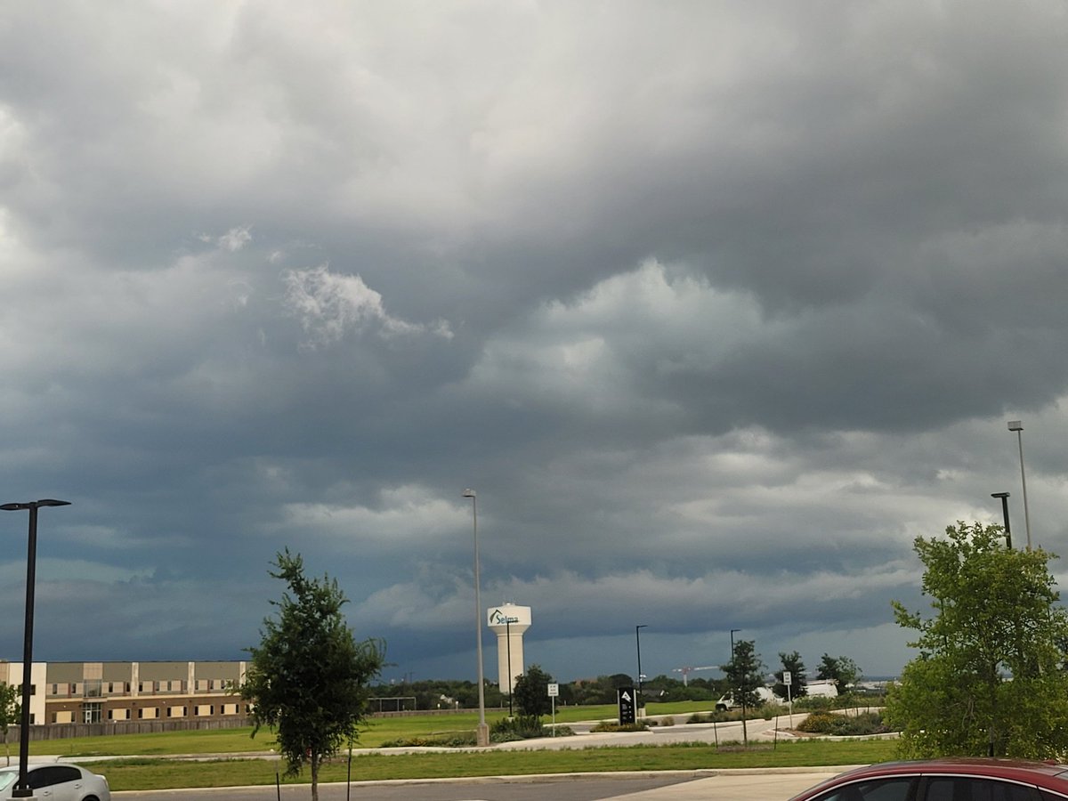
@ksatweather @KSATSarahSpivey Currently looking NW to Selma from Live Oak! FYI for your viewers.
0
1
3
Dangerous flooding continues around the city and water will take a long time to drain. Creek and rivers will continue to rise, so please use caution. TURN AROUND DON’T DROWN! #KSATnews #KSATweather #SanAntonio #SATX
0
1
2
A staggering 6.12 inches of rain has been measured at SA INTL. This San Antonio’s most 1-day rainfall in 12 years — since May 25, 2013. That’s over 4,000 days ago! Remarkably, it’s also the Alamo City’s 10th highest daily rain total of ALL TIME (records began in 1880s).
8
38
260
12:33 AM Rotation has weakened. TORNADO WARNING EXPIRED. Now a flooding threat…
0
0
11
WATCH LIVE: https://t.co/pLxSF3US3S
@adamcaskey is LIVE covering tornado warning in Bexar County. If in warning area, SEEK SHELTER!

2
3
25
Tues 9 am Storms are clipping the Hill Country and N Bexar Co this morning. These will hang around for the next couple hours, but this is just the first *opportunity* for rain More widespread activity is possible overnight through Friday. DETAILS HERE: https://t.co/wIOi1zZpCW
0
1
10
Earlier, I posted that this was the most 5 day rainfall since may of 2021, but it turns out we received 5.56” in January 2024. My apologies!
0
0
8