

Journal of Remote Sensing
@JournalofRS
Followers
452
Following
199
Media
138
Statuses
221
Science (AAAS) partner journal for leading-edge research in remote sensing. We publish original research and review articles, editorials, and perspectives.
Beijing, China
Joined January 2022
Researchers in a recent Journal of Remote Sensing study constructed a new extensible building damage dataset (EBD) of 12 disasters by leveraging deep learning and semi-supervised learning to automatically label new disaster sceness. (By Prof. Feng Zhang). #BuildingDamage,

0
0
0
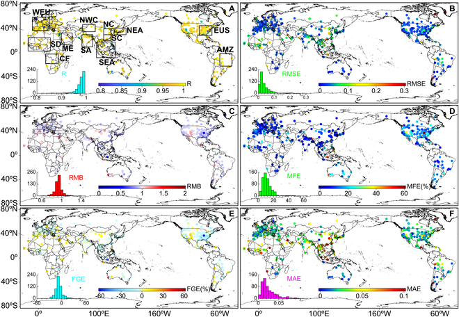
No Extra Data Needed: A Smarter CYGNSS Method for High-Accuracy Soil Moisture Mapping. Soil moisture plays a critical role in agriculture, climate forecasting, and disaster management—but satellite retrieval has long struggled in vegetated regions and relied heavily on external

0
0
0

Blazing-fast image creation – using just your voice. Try Grok Imagine.
284
566
3K
Last week, the Associate Editor of Journal of Remote Sensing (JRS), Professor Tiejun Wang was invited to the University of Helsinki in Finland to preside over the review of a doctoral student’s thesis defense. During the exchange, he enthusiastically recommended and introduced

0
0
1
🌎 From Kilometers to Meters: NISAR’s Soil Moisture Algorithm Hits Field-Scale Resolution!. Soil moisture is the lifeblood of agriculture, flood risk management, and climate resilience. Traditional satellite products only offer 30–50 km resolution—far too coarse for field-level.
0
1
4
🌎 How do we measure the water locked in snowpacks from space?. Accurate snow water equivalent (SWE) data is vital for water supply, flood forecasting, and climate research – but satellites have long struggled to deliver precise measurements, especially in complex mountain.
0
0
0
🌼Highlights: Prediction of Chla concentration changes and water quality management in lakes on the Qinghai Tibet Plateau based on Landsat images and future human activity scenarios (By Prof. Chong Fang).🔥Keywords: #Landsat images; #ClimateChange; future change; #eutrophication;
0
0
2
✨Highlight: A new urban 3D reconstruction method enhances Tomographic Synthetic Aperture Radar (TomoSAR) imaging using geometric semantics. By incorporating building structures into a Bayesian framework, the method—Geometric Semantic Enhanced TomoSAR Reconstruction Algorithm
0
0
2
☀️Producing roughly one-third of global food while hosting the majority of food insecure, smallholder farmers and marginalized communities paradoxically constitute a large proportion of the world’s 735 million chronically hungry people due to systemic vulnerabilities. Hunger
0
1
3
Quantitative Assessment of the Uncertainty in Aerosol Optical Property Inversion due to Different Surface Reflection Models.🛰️Highlights: A new study improves satellite-based aerosol measurements by assessing how different surface reflection models impact inversion accuracy.The
0
0
1
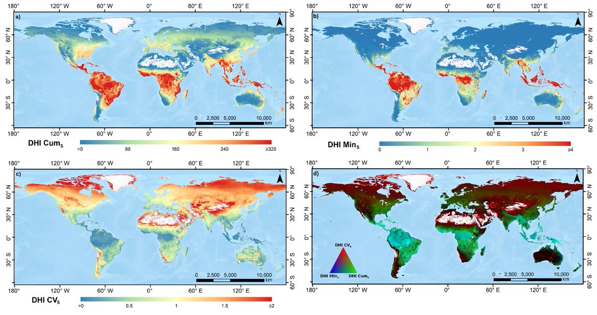
Bridging Satellite Productivity and Global Biodiversity: Unveiling Insights through Dynamic Habitat Indices.🌼Highlights: Dynamic Habitat Indices (DHIs) calculated using satellite productivity measures are powerful and scalable tool for linking Earth observations to global
0
2
6
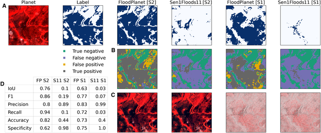
Assessing Inundation Semantic Segmentation Models Trained on High- versus Low-Resolution Labels using FloodPlanet, a Manually Labeled Multi-Sourced High-Resolution Flood Dataset.💡Highlights: This study curates and publicly releases FloodPlanet, a manually labeled inundation
0
0
3
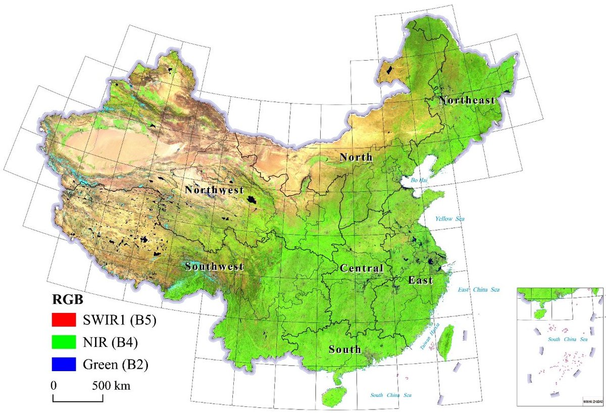
Title: Seamless Annual Leaf-On Landsat Composites for China from 1985 to 2023.💡Highlights: This research developed a long-term, seamless Landsat image compositing method to generate annual cloud-free, Leaf-On imagery for China (1985–2023), enabling nationwide, analysis-ready
0
0
2
BPUM: A Bayesian Probabilistic Updating Model Applied to Early Crop Identification. Highlights: .1⃣This study proposes a Bayesian Probability Update Model (BPUM) for early crop identification. This model combines historical crop planting information and current remote sensing

0
0
1
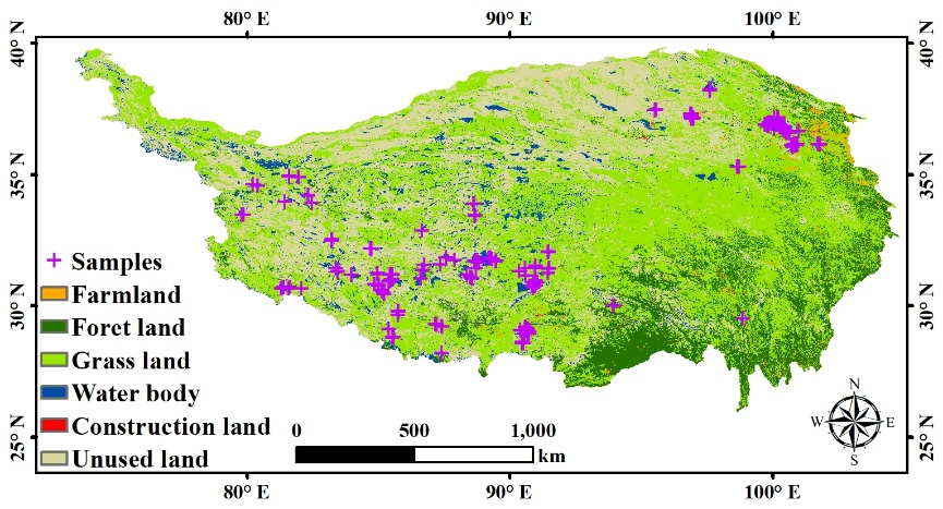
A Global Review of Monitoring Cropland Abandonment Using Remote Sensing: Temporal–Spatial Patterns, Causes, Ecological Effects, and Future Prospects.🌼Highlights: This work systematically reviews remote sensing-based methods for monitoring abandoned cropland, including its causes

0
1
6
RT @JournalofRS: 💡Highlights:This study developed a simple and efficient multispectral remote sensing index, the Spartina alterniflora Inde….
0
2
0
💡Highlights:This study developed a simple and efficient multispectral remote sensing index, the Spartina alterniflora Index (SAI), which enhances the spectral contrast between red and near-infrared bands to enable accurate identification of small patches of Spartina

0
2
3
RT @JournalofRS: 🍃Title: Improved soybean mapping with spectral Gaussian mixture modeling.🌱Highlights: Integration of canopy greenness, wat….
0
1
0
🍃Title: Improved soybean mapping with spectral Gaussian mixture modeling.🌱Highlights: Integration of canopy greenness, water content, and chlorophyll characteristics, and use of improved Bhattacharyya Coefficient weights for robust global soybean mapping. 🔑Keywords:

0
1
2
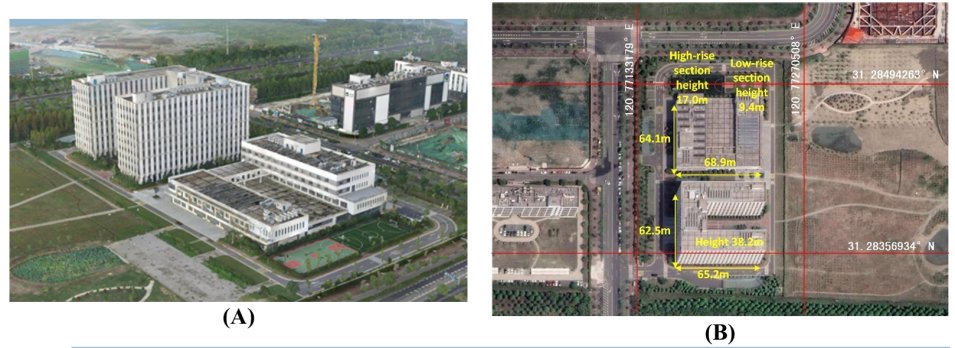
⚡️Highlights: In this study, we pioneered the Seasonal Tree Height Neural Network (STHNN) integrating multi-source remote sensing data and SHAP optimization, and realized the dynamic seasonal monitoring of tree height in Shenzhen (R²=0.80, MAE=1.58 m), revealing the seasonal

0
0
3