
Jake Parrish
@JParrishWX
Followers
2K
Following
2K
Media
874
Statuses
7K
AP Award winning Meteorologist, @redcross Disaster Action Team, volunteer fire, @spectrumnews1tx freelance met, @imfletchcast co-host. Runner, CF. Based in ATX.
Austin, TX
Joined December 2011
Looking iffy for the eclipse…#txwx
Here is the eclipse cloud cover forecast as of April 4th. There has been little change in the forecast, with mostly cloudy skies anticipated across south-central Texas. Continue to check back for updates as the forecast evolves. #Eclipse2024 #txwx
0
0
4
We are officially one month away from a total solar eclipse happening on April 8th, 2024. Now is the time to find eclipse glasses to make sure you're ready! Remember, ordinary sunglasses are not enough to protect your eyes when viewing before totality is reached. #txwx
4
11
38
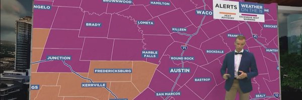
Update 1/15/24 @ 4 A.M.
Here is the latest on our winter weather headlines and AM ice accumulations, including the recently issued Winter Storm Warning from I-35 east across the Coastal Prairies. The winter weather products expire at noon today, but the Hard Freeze Warning will extend into Wednesday.
0
1
3
Ugh, just ran in this cold. @3mhalfmarathon next weekend looks warmer, thank goodness. Stay safe! #txwx
The previously issued Wind Chill Advisory has been extended through Wednesday morning, and a Hard Freeze Warning has been issued to complement it. We've also attached the forecast minimum temperature and wind chill graphics for Monday morning (MLK Day). #txwx
0
0
3
1/14/24 update: Icing possible late Sunday into Monday morning. Wind Chill Advisory active during that time as well. Stay alert! #txwx
Winter Weather Advisory now in effect from 6 pm Sun to Noon Mon. Ice Accumulations from 0.01-0.10" possible, mainly on bridges, overpasses, and elevated surfaces. Plan accordingly.
0
0
2
Update 1/13/24 on upcoming cold/ice potential. Stay safe! #txwx
At least the daytime temperatures will be nice today. Tonight an arctic air surge is set to arrive. Wind chills late tonight could fall into the teens. Freezing rain is possible Sunday night into Monday. Prepare the four "P"s for hard freezes for 3-4 days in a row.
0
0
1
Strong front late Sunday, 1/14/24 #txwx
Confidence continues to increase that the strongest front of the season will arrive Sunday night. There is a 20-30% chance that highs Monday could stay below freezing and high probabilities that lows Tuesday morning will be below 25 degrees for much of the area.
0
0
0
Goal of running 1,000+ miles in 2023 accomplished! 🤞for more in 2024!
1
0
2
Cold Monday morning 12/11/23, for central Texas! #txwx
A Freeze Warning has been issued for portions of South Central Texas tonight into Monday morning. Some locations, especially city centers, may not reach the 32 degree mark, but plan accordingly it will still be colder than we have seen in a while! #txwx
0
0
2
FYI for Thursday, November 30th, 2023. #txwx
Midday update: The tornado risk has shifted slightly east, with a maximum level 2 of 5 threat now in south-central Texas. People in the dark green and yellow shaded areas should be prepared in case warnings are issued, with the highest risk along US-77 between 8a-2p.
0
0
3
You won’t find a better human than @hwinkler4real. Just finished his new book, highly recommended!
1
0
8
Big drop in temperature coming soon! #txwx
A dramatic drop in temperatures arrives Sunday with well below normal temps forecast for a good part of the upcoming work week. Blustery winds developing behind the front will lead to widespread cold wind chill index values in the 20s and 30s by early Monday morning.
0
0
4
Moderate excessive rainfall threat for much of central Texas through Thursday morning, 10/26/23. #txwx

A MODERATE risk is in effect in our Day 1 Excessive Rainfall Outlook. More details: https://t.co/FQU5sbmsxo
0
0
2

At the end of our episode with Dana Wheeler-Nicholson, we toyed with the idea of Fletch Con… the very talented @MarkBeer4 illustrated what that might look like! Amazing! #fletch #fletchcast #fletchcon #chevychase
1
4
9