

India Meteorological Department
@Indiametdept
Followers
351,243
Following
62
Media
21,418
Statuses
47,820
This is the Official Twitter handle of India Meteorological Department, Ministry of Earth Sciences, Government of India.
New Delhi
Joined April 2016
Don't wanna be here?
Send us removal request.
Explore trending content on Musk Viewer
#WeAreSeriesEP7
• 81967 Tweets
#บางกอกคณิกาep3
• 78549 Tweets
PondPhuwin WeAre EP7
• 40989 Tweets
SKZ ON GOOD MORNING AMERICA
• 24216 Tweets
#Aぇヤンタン
• 21713 Tweets
バッカーノ
• 21325 Tweets
$MISTY
• 14738 Tweets
松本健吾
• 13979 Tweets
PIERROT
• 13556 Tweets
Bコース
• 12323 Tweets
村上200号
• 12278 Tweets
#şüküriçinadalet
• 12058 Tweets
トネリコ
• 10574 Tweets
Aコース
• 10011 Tweets


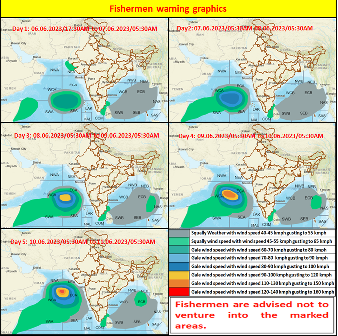
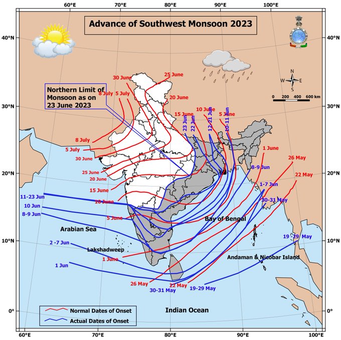
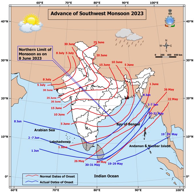
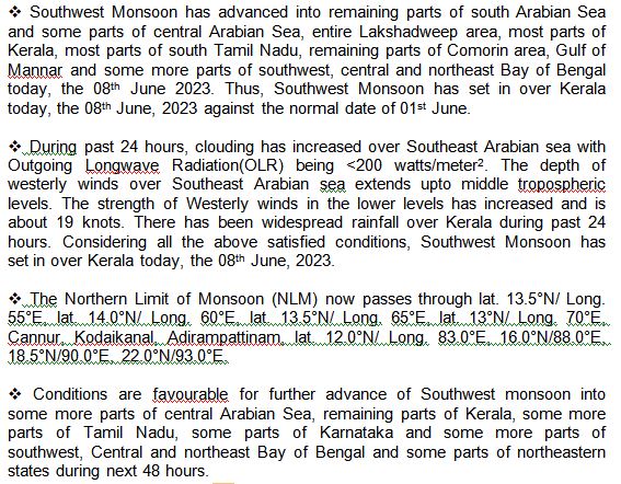
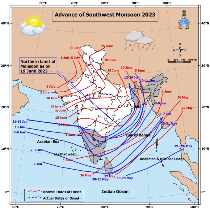
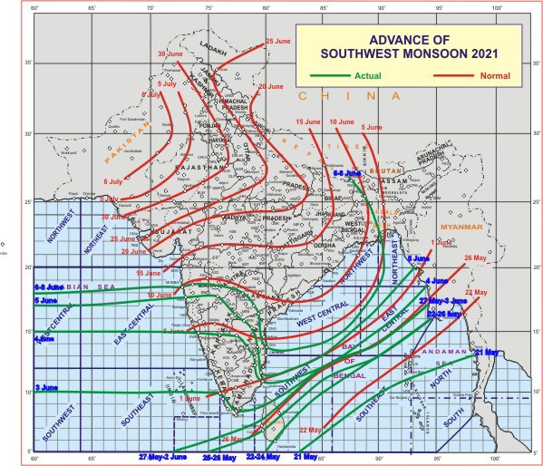
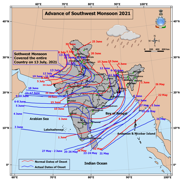
Southwest Monsoon has set in over Kerala today, the 08th June, 2023 against the normal date of 01st June.

45
1K
9K
Congratulations India !!! Dr. Mrutyunjay Mohapatra has won the election for the position of Third Vice President of WMO. A resounding victory. Received 113 votes (out of 148).
93
323
2K
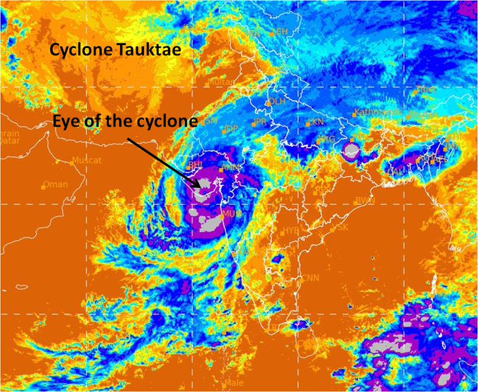
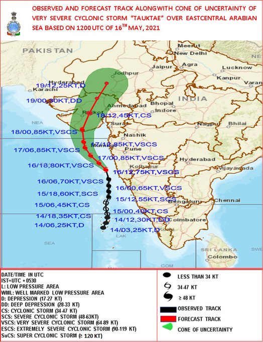
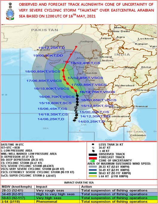
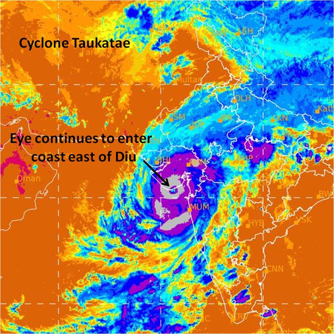
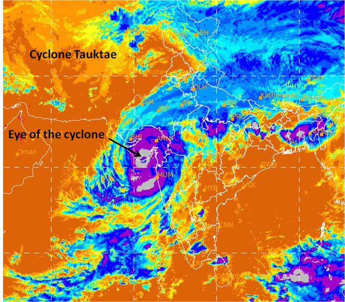
Cyclone Tauktae
Diu reported 133kmph wind speed at 9.30 pm.
14
327
2K
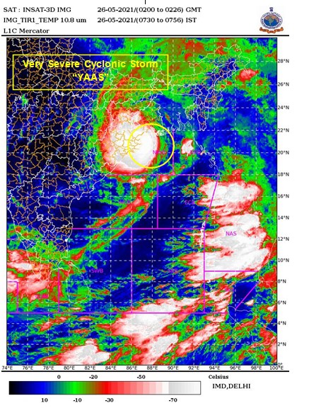
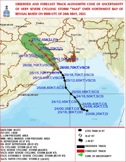
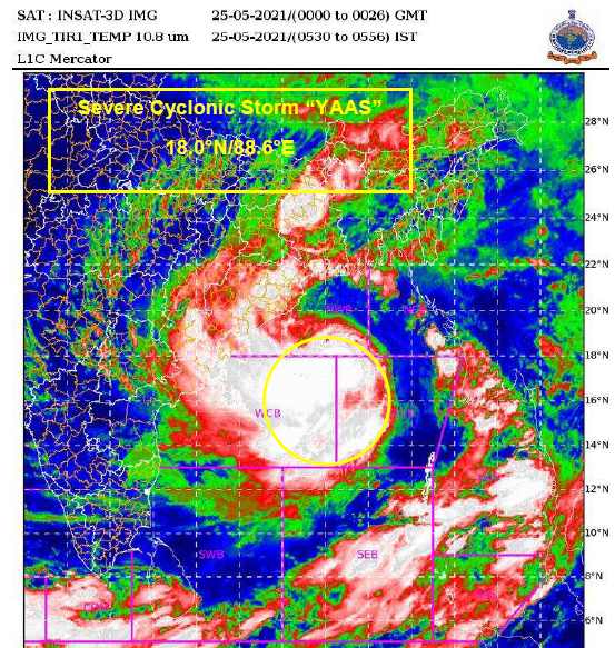
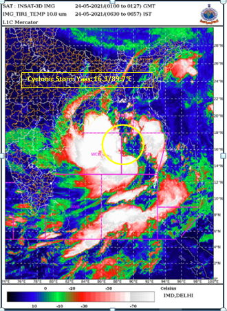
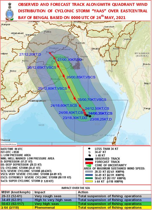
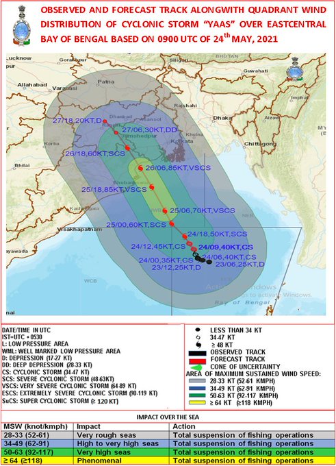
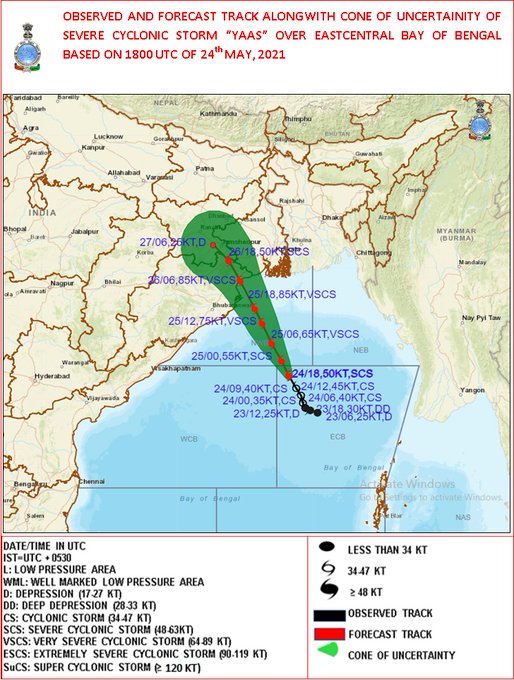
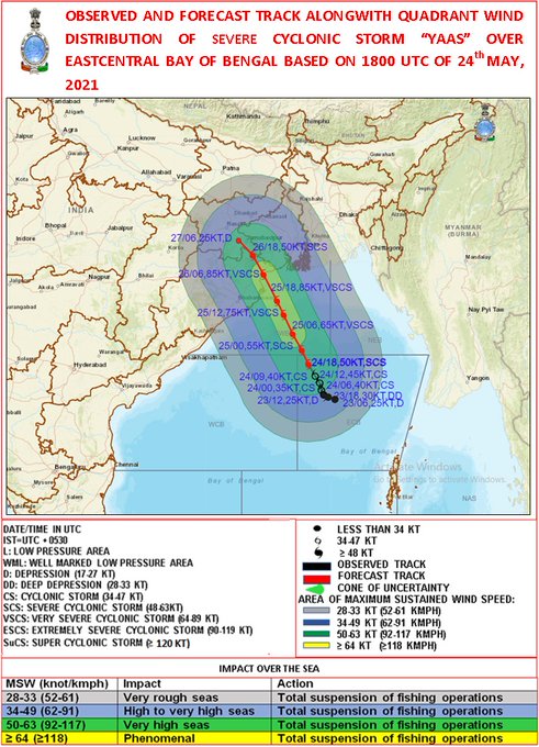
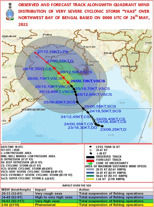
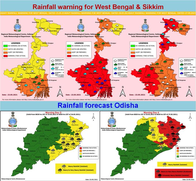
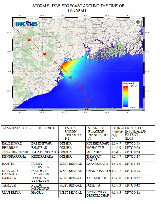
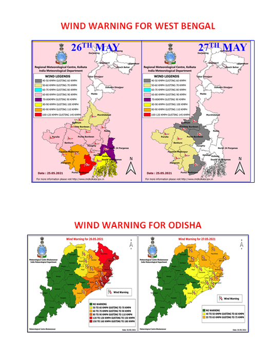
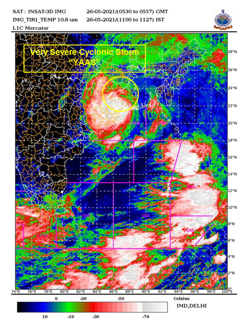
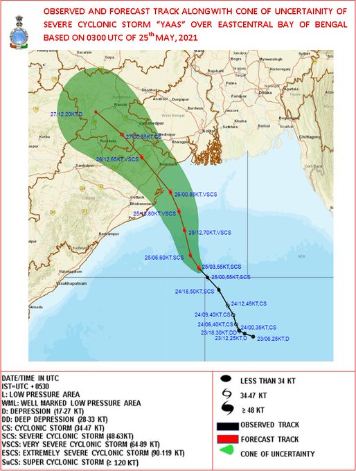
Very Severe Cyclonic Storm YAAS to cross Odisha coast between Dhamra and Balasore around noon of 26th May with wind speed of 130-140KMPH.
15
240
2K
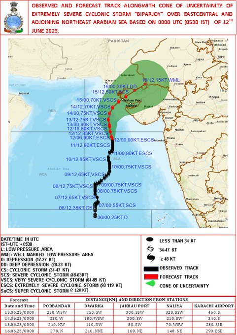
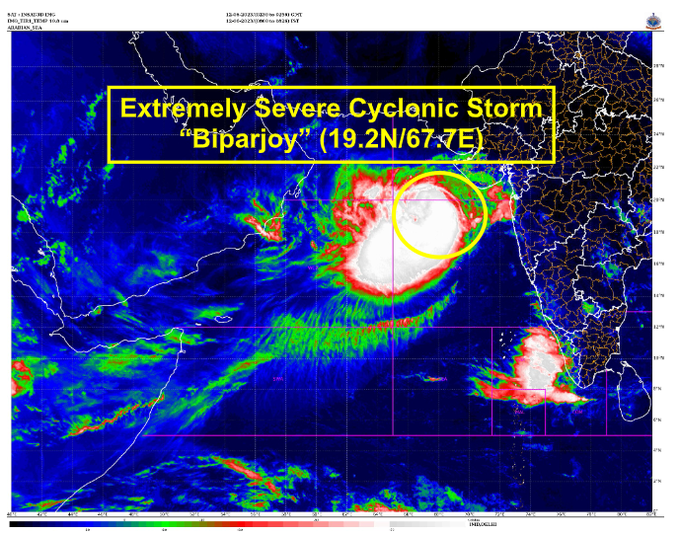
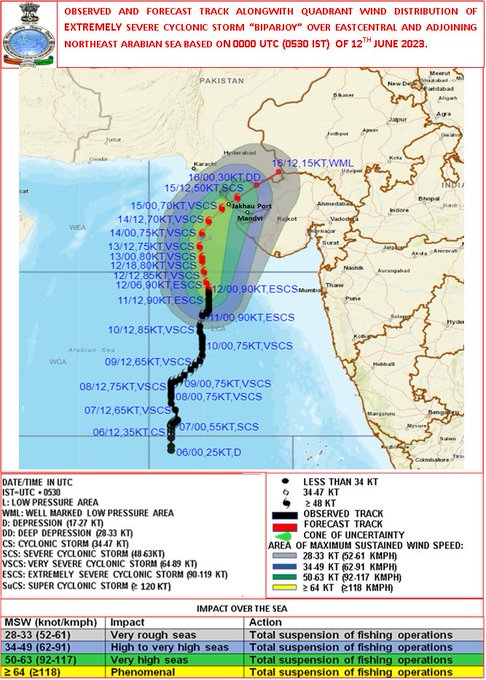
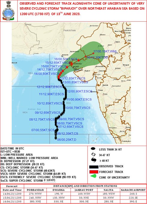
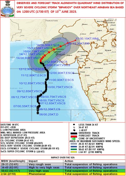
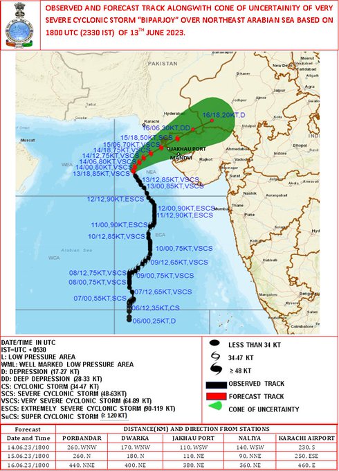
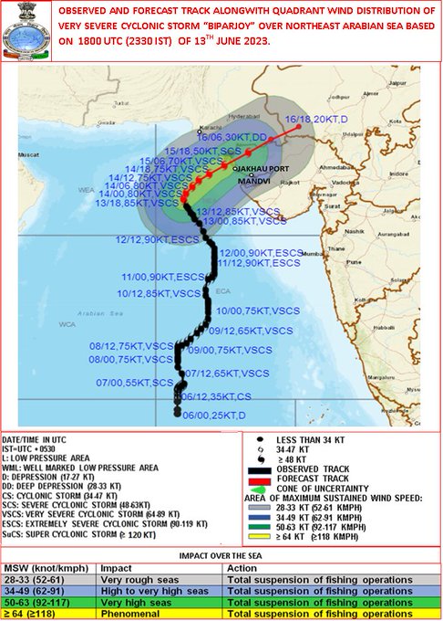
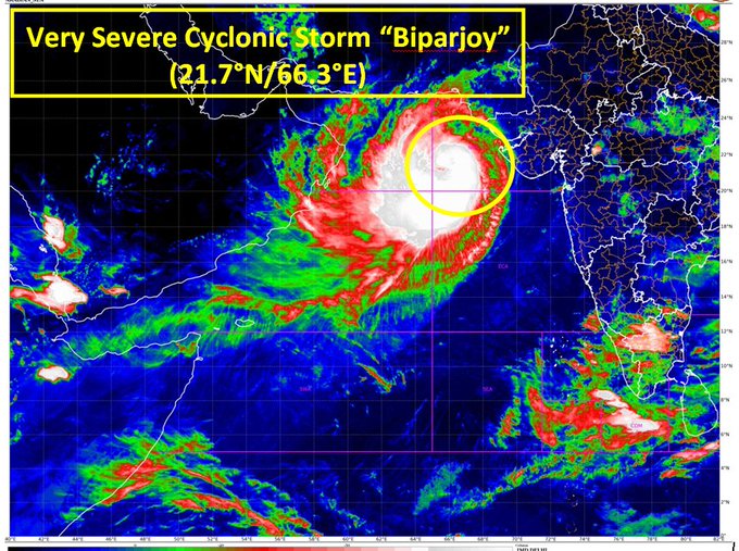
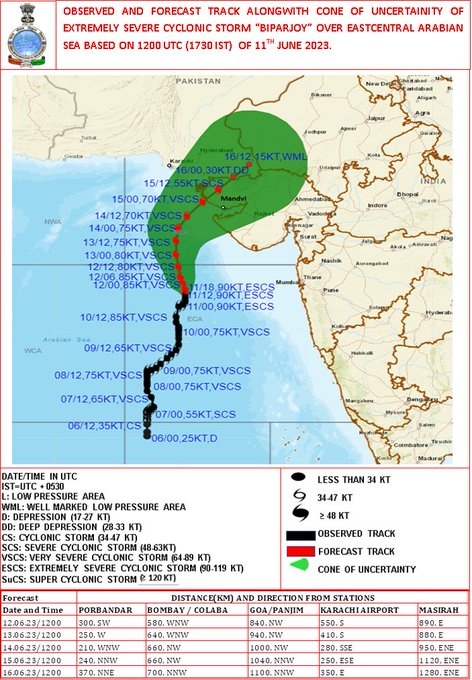
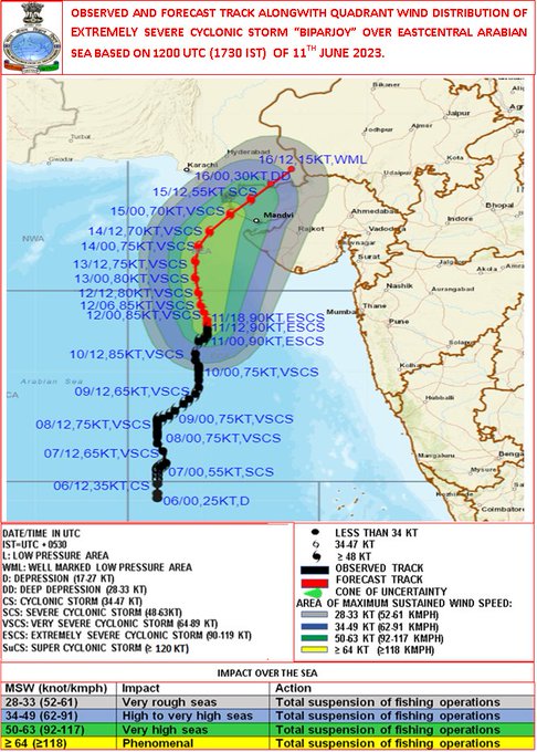
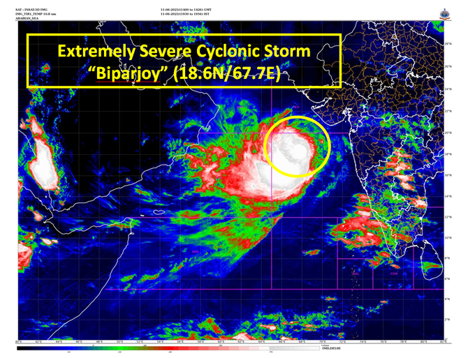
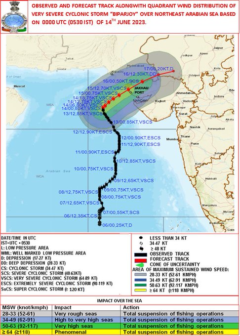
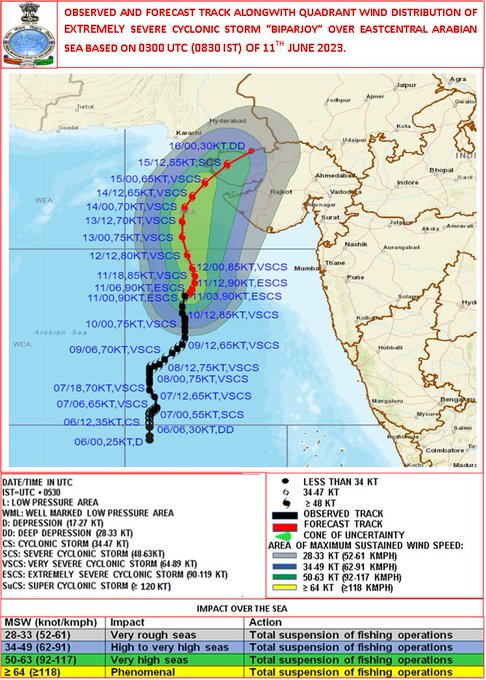
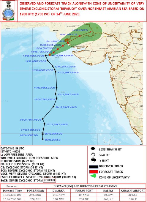
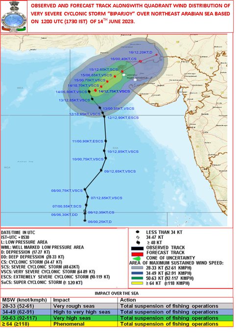
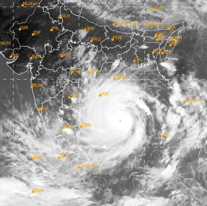
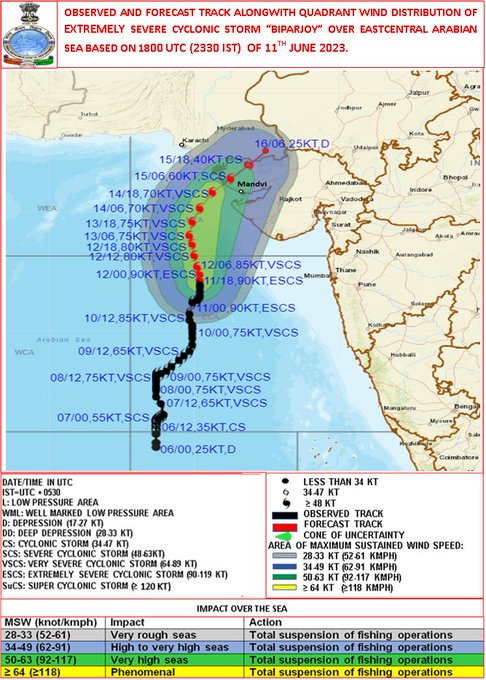
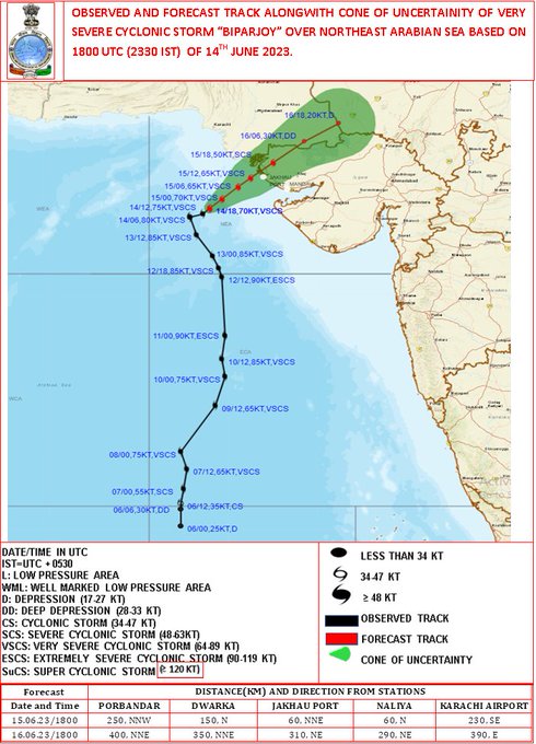
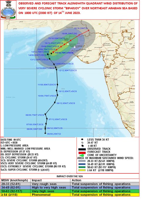
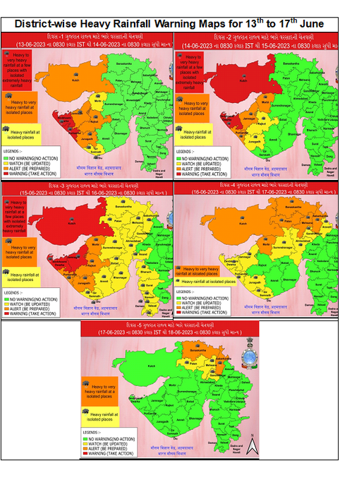
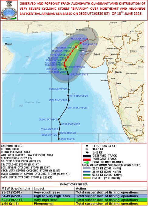
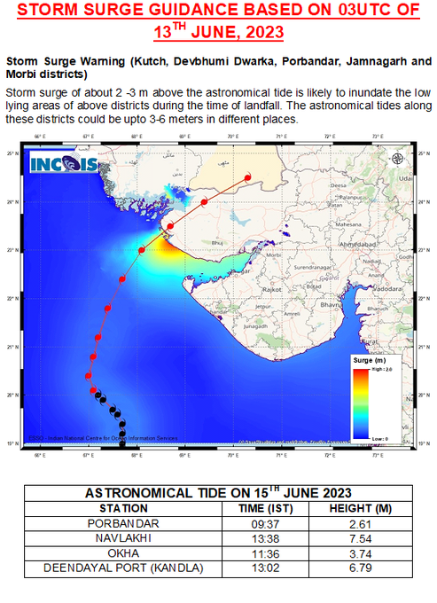
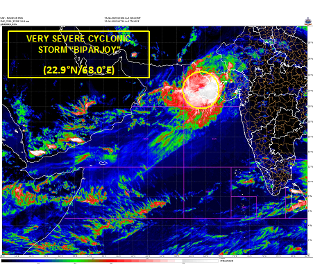
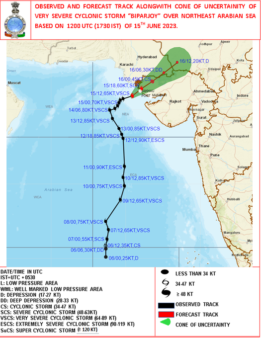
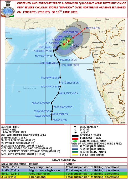
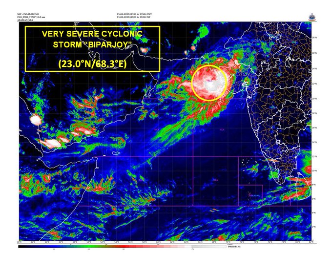
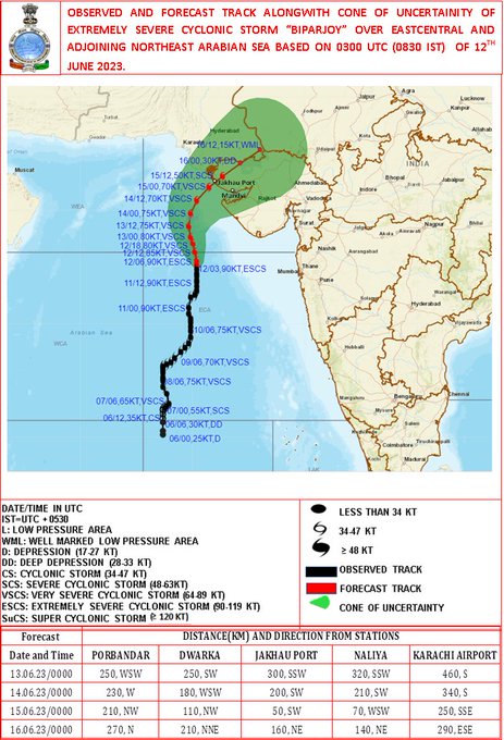
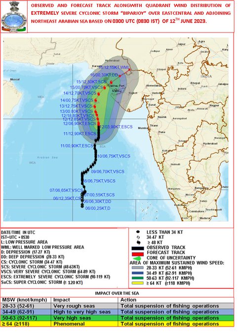
Cyclone Alert for Saurashtra & Kutch Coast: Orange Message. ESCS BIPARJPY at 0530IST of today over eastcentral & adjoining NE Arabian Sea near lat 19.2N & long 67.7E, about 380km SSW of Devbhumi Dwarka. To cross near Jakhau Port,Gujarat by noon of 15June.
10
230
2K
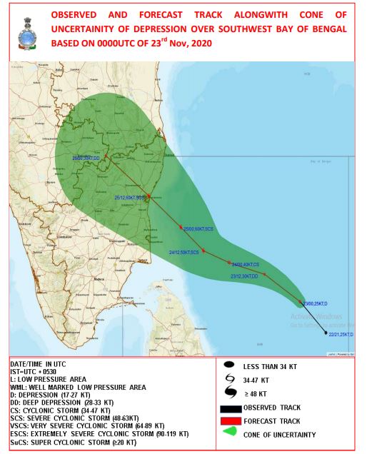
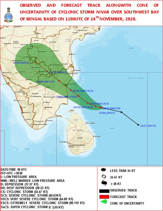
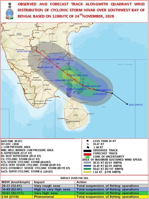
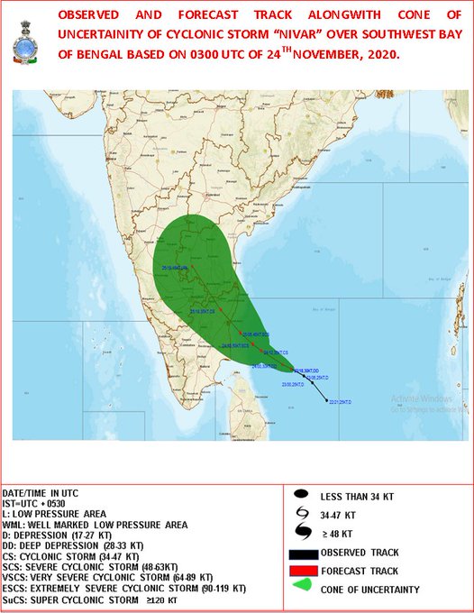
IMD has predicted landfall point of Cyclone "NIVAR" b/w Karaikal and Mamallapuram close to Puducherry in its 1st track forecast at 0530 IST of 23th Nov, i.e. 3 days in advance.
Forecasted landfall point (3 days in advance) and actual landfall point r attached:
59
173
1K
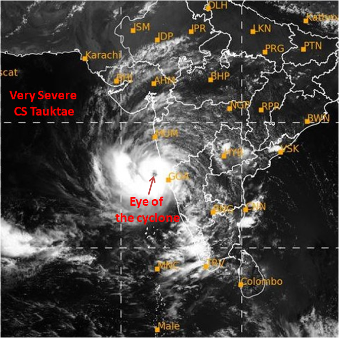
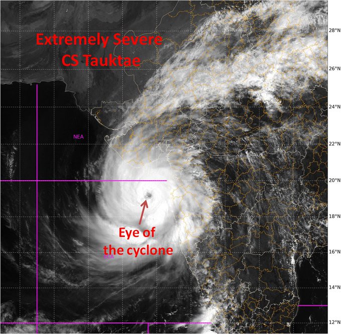
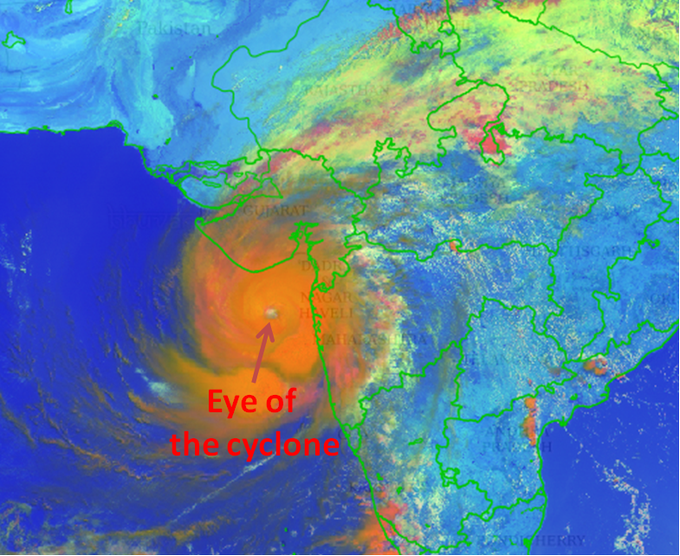
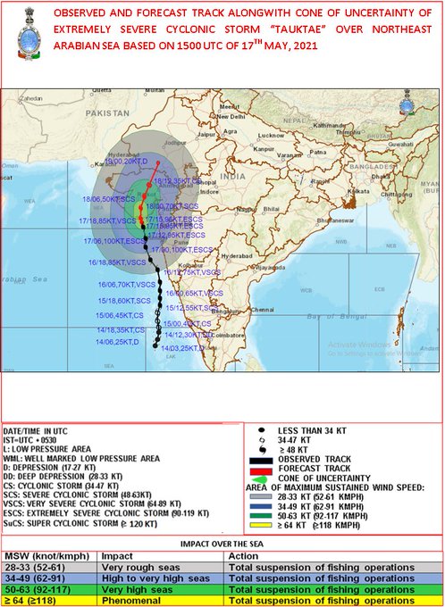
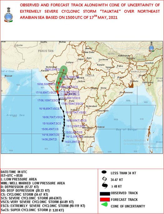
Very severe cyclonic storm 'Tauktae' has intensified further in last 3 hours. The eye of the cyclone is now cleraly observed in the INSAT-3D satellite imagery at 1130 IST. The diameter of eye is roughly 4 km with eye temperature -5.2°C. The wall cloud top temperature is -93°C.
19
404
1K
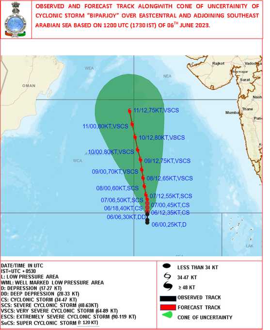
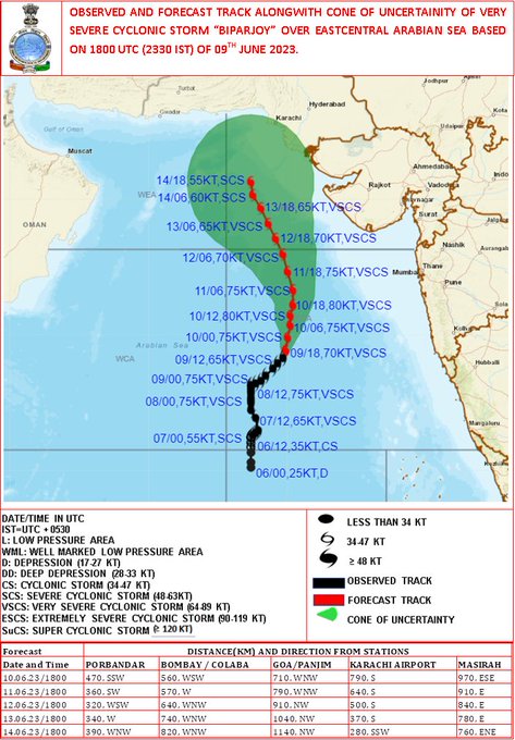
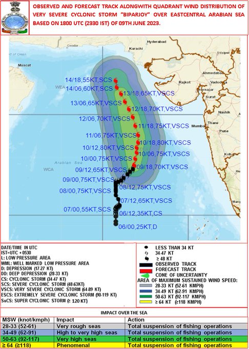
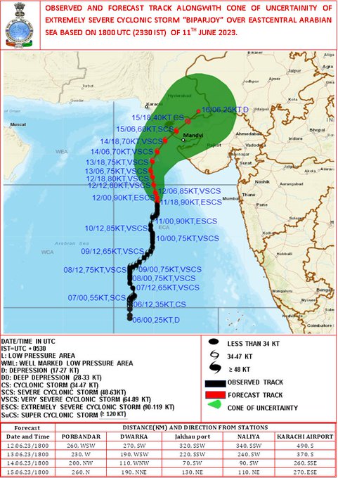
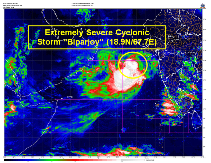
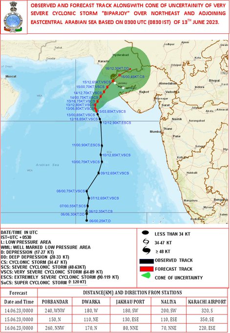
Deep Depression intensified into Cyclonic Storm BIPARJOY over Eastcentral Arabian Sea at 1730hrs IST. To move nearly northwards and intesify into a severe cyclonic storm during next 24 hours. For details kindly visit .
13
159
1K
The Southwest Monsoon has further advanced into some more parts of Karnataka, Telangana, remaining parts of Andhra Pradesh, some parts of Vidarbha, Chhattisgarh, remaining parts of Northwest Bay of Bengal, remaining parts of Odisha & Gangetic West Bengal, 1/2
11
155
1K
VERY SEVERE CYCLONIC STORM YAAS CENTRED ABOUT 50 KM SOUTH-SOUTHEAST OF BALASORE.LANDFALL PROCESS HAS COMMENCED AROUND 0900 HRS IST.

19
250
1K
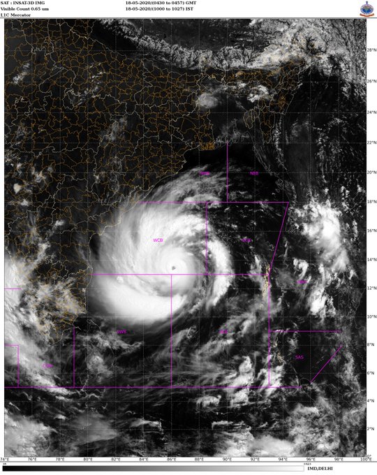
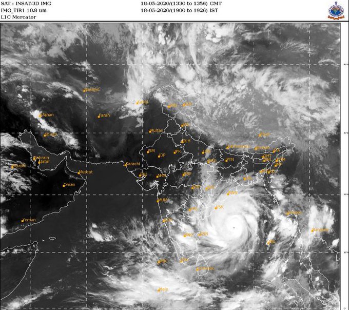
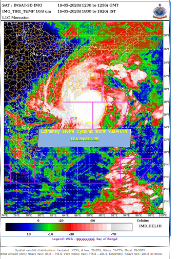
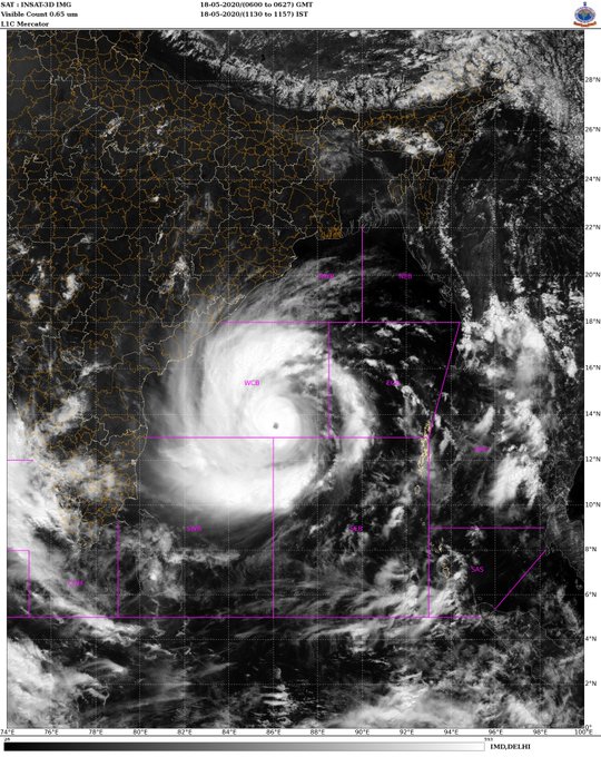
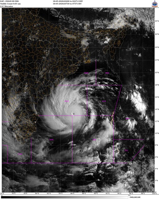
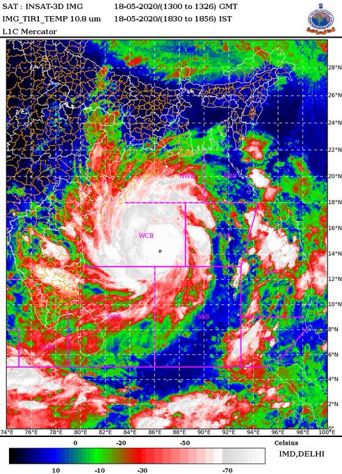
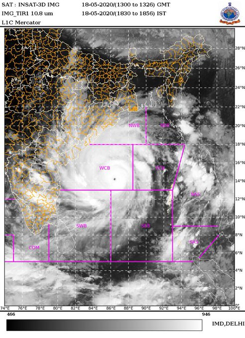
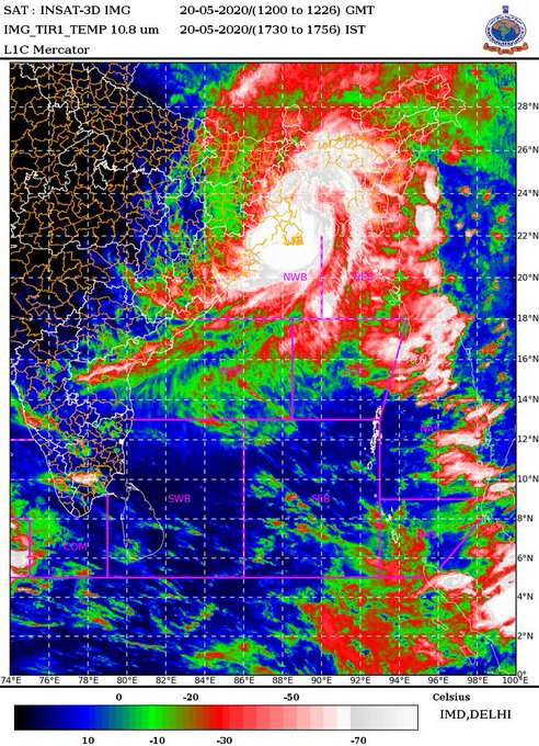
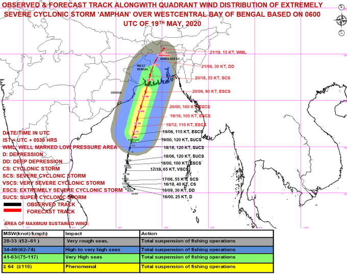
Extremely Severe Cyclonic Storm ‘AMPHAN’: 18th May 2020 (1000 to 1027 IST). Likely to intensify further as Super Cyclone.
44
452
1K
Southwest Monsoon has set in over Kerala today, the 08th June, 2023.
for more information:
#India
#IMD
#heatwave
#weather
#WeatherUpdate
,
@DDNewslive
, ,
@ndmaindia
,
@airnewsalerts
,
@moesgoi
10
177
1K
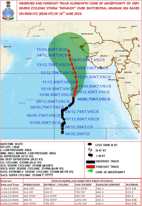
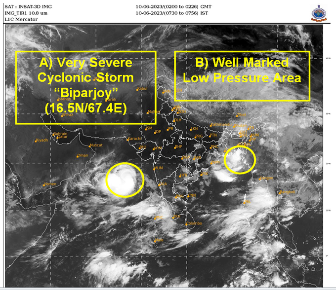
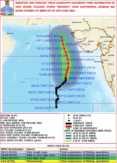
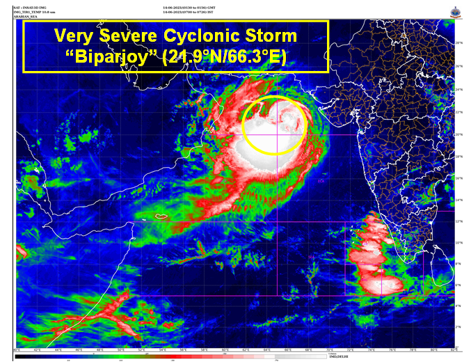
VSCS “Biparjoy” over eastcentral Arabian Sea, lay centered at 0530hrs IST of 10th June, near lat 16.5N & long 67.4E, likely to intensify further & move north-northeastwards during next 24 hours. More details:
10
147
1K
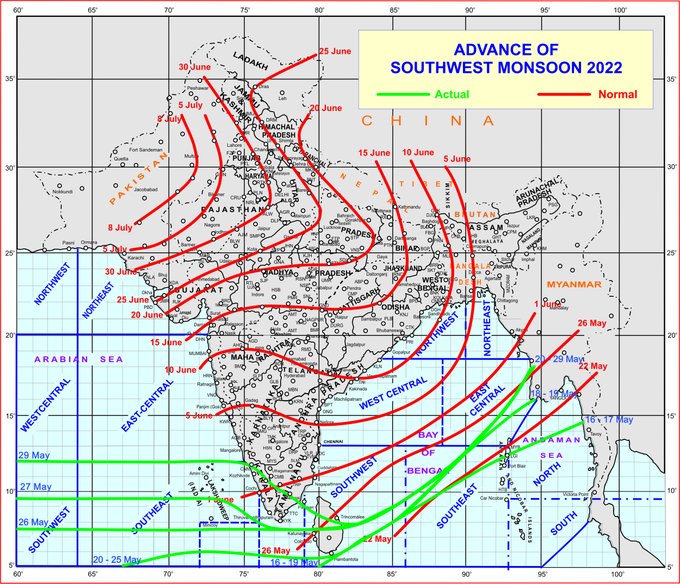
Southwest Monsoon has set in over Kerala today, the 29th May , 2022
25
203
1K
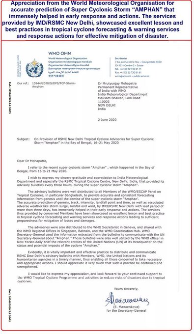
An Appreciation letter from WMO for accurate forecast and information dissemination during cyclon Amphan👏👏👏👏
37
156
998
LANDFALL PROCESS IS CONTINUING, IT WILL TAKE ANOTHER 03 HOURS TO COMPLETE THE LANDFALL PROCESS.
7
142
916
VSCS BIPARJOY at 2330 hrs IST of 09th June over eastcentral Arabian Sea near lat 16.0N & long 67.4E. Likely to intensify further & move north-northeastwards during next 24hrs. for details visit:
6
87
918
THE CENTER OF THE SEVERE CYCLONE "NISARGA" IS VERY CLOSE TO MAHARASHTRA COAST. LANDFALL PROCESS STARTED AND IT WILL BE COMPLETED DURING NEXT 3 HOURS. THE NORTHEAST SECTOR OF THE EYE OF SEVERE CYCLONIC STORM “NISARGA” IS ENTERING INTO LAND.
11
250
864
Cyclone Warning for Saurashtra & Kutch Coasts: Orange Message. VSCS BIPARJOY at 1730IST of today over NE Arabian Sea near lat 21.3N & long 66.5E, about 290km WSW of Devbhumi Dwarka. To cross near Jakhau Port (Gujarat) by evening of 15th June as VSCS. More:
4
151
879
In association with an east-west trough from Northwest Rajasthan to Northwest Bay of Bengal and huge moisture feeding to the trough from Arabian Sea and the Bay of Bengal; Intense monsoon clouds visible over East Rajasthan, north MP and East UP. 1/2
5
78
881
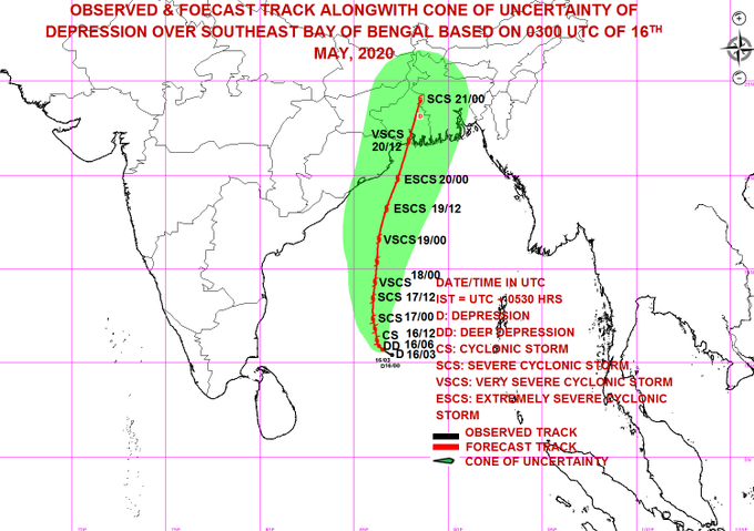
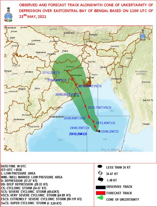
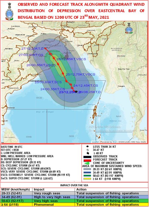
DEPRESSION OVER SE BoB AND NEIGHBOURHOOD NEAR LATITUDE 10.7°N AND LONGITUDE 86.5°E, ABOUT 1060 KM SOUTH OF PARADIP (42976) (ODISHA).TO INTENSIFY RAPIDLY INTO A CYCLONIC STORM DURING NEXT 12 HOURS AND FURTHER INTO A SEVERE CYCLONIC STORM DURING SUBSEQUENT 24 HOURS.
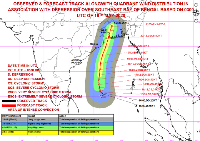
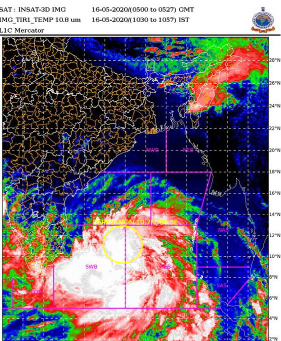
11
182
861
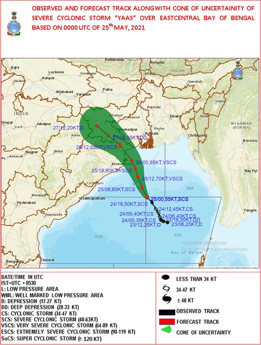
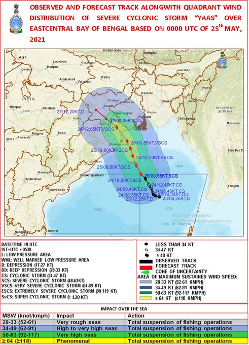
SCS ‘Yaas’ lay centred at 0530 hrs IST of today, about 320km SSE of Paradip, 430km SSE of Balasore, likely to move north-northwestwards, to cross north Odisha coast during noon of 26th May as a VSCS.
23
189
853
The ESCS TAUKTAE lies close to Gujarat coast. The landfall process started and will continue during next 02 hours.
17
235
826
Very Severe Cyclonic Storm “Tauktae” over Eastcentral Arabian Sea intensified into an Extremely Severe Cyclonic Storm: Cyclone Warning & post landfall outlook for Gujarat & Diu coasts (Red message).
10
263
791
Landfall process is continuing. It will take around 3 hours to complete. 30 km south-southeast of Balasore at 0930 hours IST.
7
102
802
SEVERE CYCLONIC STORM "NISARGA" CROSSED THE COAST BETWEEN 12:30 IST & 14:30 IST OF 03.06.2020 WITH A WIND SPEED OF 100-110 KMPH GUSTING TO 120 KMPH.
22
172
748
Weather is a chaotic dynamical system and very sensitive to any changes in its hundreds of parameters. Overcoming random states of disorder and irregularities and forecasting to serve the society and Human Welfare is the prime goal of IMD. We are always improving and updating us.
24
54
733
Cyclone Warning for Saurashtra & Kutch Coasts: Orange Message. VSCS BIPARJOY at 2330 IST of 13th June over NE Arabian Sea near lat 21.7N & long 66.3E, about 300km WSW of Devbhumi Dwarka. To cross near Jakhau Port (Gujarat) by evening of 15th June as VSCS.
3
76
715
Cyclone Alert for Saurashtra & Kutch Coast: Yellow Message. ESCS BIPARJOY over eastcentral Arabian Sea, at 1730 IST of 11th June near lat 18.6N & long 67.7E, Likely to cross between Mandvi (Gujarat) & Karachi (Pakistan) by noon of 15thJune. More details:
3
90
718
Deep Depression over Eastcentral Bay of Bengal intensified into Cyclonic Storm ‘Yaas’ and about 600 km of Port Blair. To intensify into a Severe Cyclonic Storm during next 24 hours and into a Very Severe Cyclonic Storm during subsequent 24 hours.
19
182
708
Southwest monsoon has further advanced into some more parts of Karnataka, Andhra Pradesh, Westcentral & Northwest Bay of Bengal; some parts of Gangetic West Bengal & Jharkhand; some more parts of Bihar & remaining parts of Sub-Himalayan West Bengal & Sikkim today, the 19th June.
6
101
705
VERY SEVERE CYCLONIC STORM ‘TAUKTAE’ MOVED NORTH WARDS WITH A SPEED OF 15 KMPH DURING PAST 06 HOURS.
1
64
657
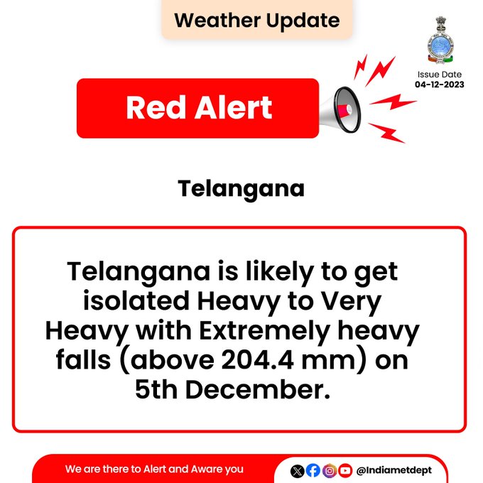
🚨
#Telangana
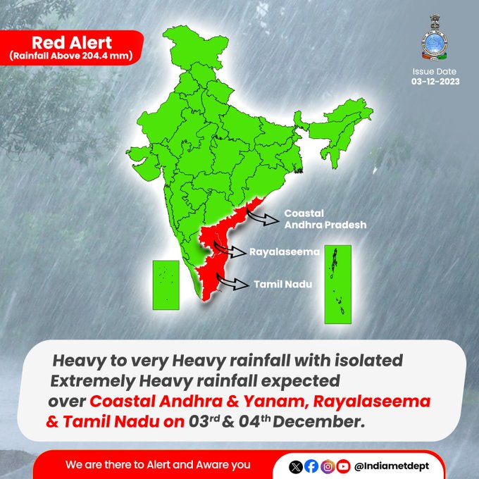
is about to experience heavy to very heavy rainfall with extremely heavy falls (above 204.4 mm) on 5th December. Stay alert, stay safe!
9
127
663
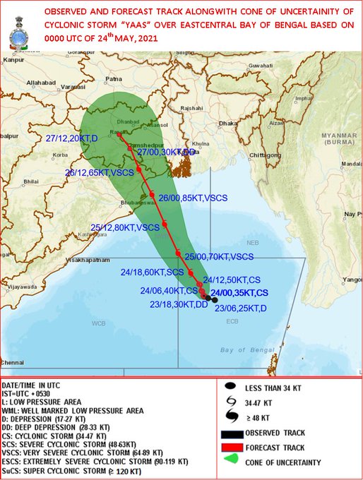
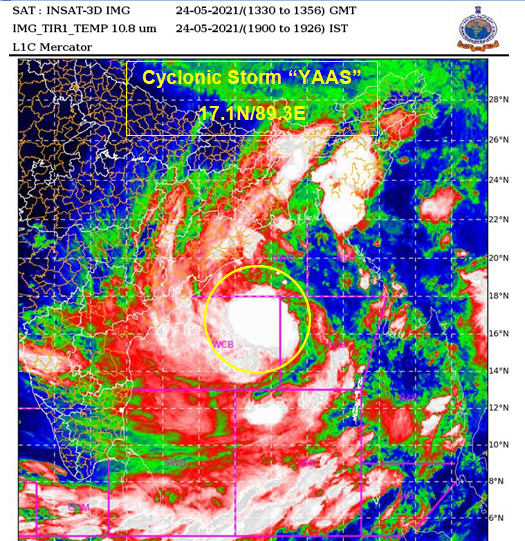
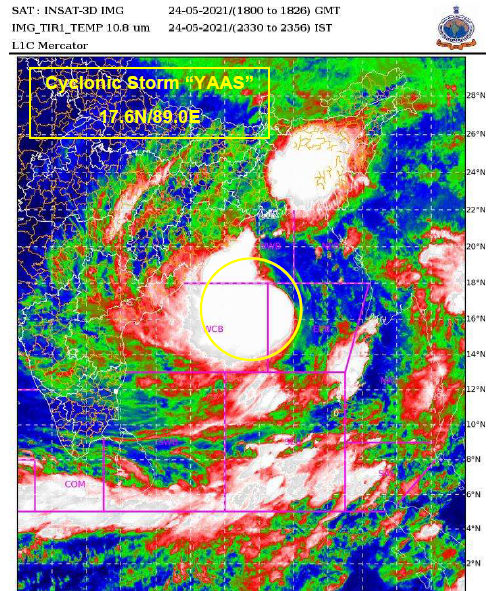
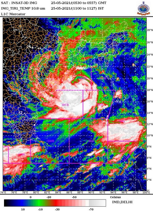
YAAS over Eastcentral BoB, lay centred at 1730 hrs IST of 24th May about 450 km south-southeast of Paradip (Odisha) and 540 km south-southeast of Digha (WB), move north-northwestward, to cross between Paradip and Sagar Island around Balasore, during noon of 26th May as a VSCS.
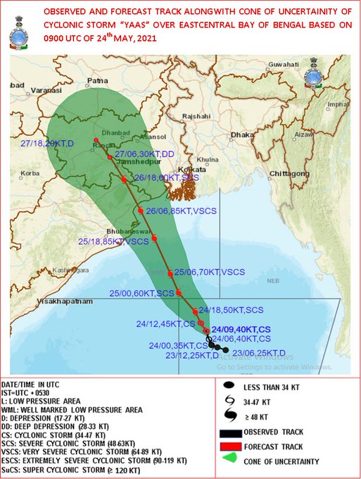
9
155
626
Very Severe Cyclonic Storm ‘Yaas’ , located about 160 km east-southeast of Paradip (Odisha), 250 km south-southeast of Balasore ( intensify further and to cross north Odisha-West Bengal coasts between Paradip and Sagar Islands during 26th May as a VSCS.
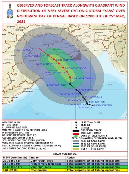

11
165
628
SOUTHWEST MONSOON HAS SET IN OVER SOUTHERN PARTS OF KERALA TODAY, THE 03RD JUNE, 2021. DETAILS IN THE PRESS RELEASE TO BE ISSUED SOON
@rajeevan61
13
123
629
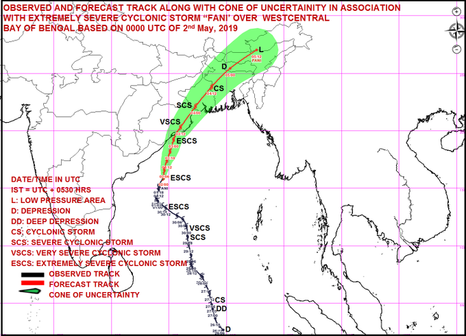
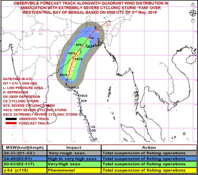
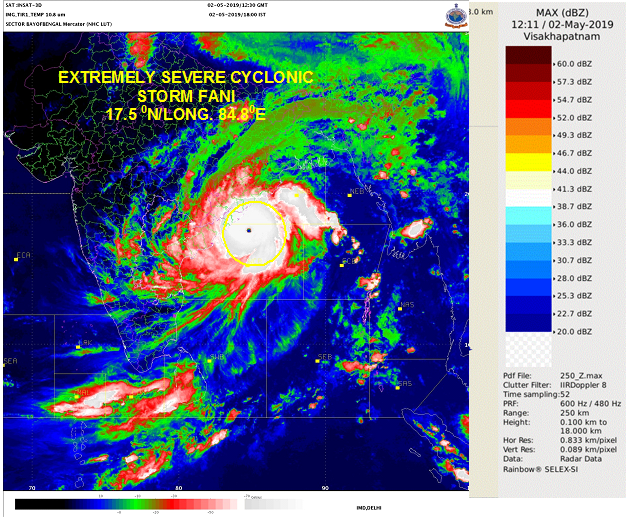
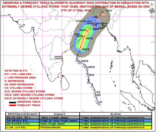
Extremely Severe Cyclonic Storm FANI about 450 km south-southwest of Puri at 0530 hrs IST of 02nd May, 2019. To cross Odisha coast around Puri by afternoon of 3rd May.
29
398
586
Cyclone Warning for Saurashtra & Kutch Coasts: RED MESSAGE. VSCS BIPARJOY at 0530IST of today over NE Arabian Sea near lat 21.9N & long 66.3E, about 280km WSW of Jakhau Port (Gujarat), 290km WSW of Devbhumi Dwarka. To cross near Jakhau Port (Gujarat) by evening of 15June as VSCS.
4
152
623
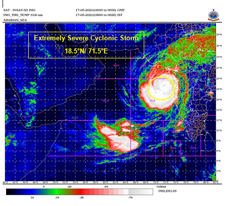
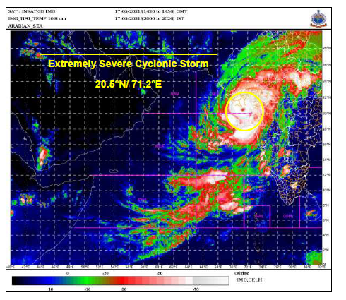
Extremely Severe Cyclonic Storm Tauktae
INSAT 3D satellite-based centre position
at 1030 IST - 19.1N & 71.5E
which is 193 km south-southeast of Diu
12
149
610
The CS YAAS intensified into a Severe Cyclonic Storm, lay centred at 1800 UTC of 24th May about 390km SSE of Paradip, likely to move north-northwestwards, to cross between Paradip and Sagar Island around Balasore, during noon of 26th May as a Very Severe Cyclonic Storm.
8
142
621
Depression has formed over eastcentral BOB at 1130 IST.Itwould intensify further and cross north Odisha-West Bengal coast betweenParadeep and Sagar Island by 26th evening as a Very Severe Cyclonic Storm. For more detail :
14
170
611
Southwest Monsoon is likely to advance into more parts of Maharashtra (including Mumbai) today the 09th June and likely to advanced into more parts of Telangana and Andhra Pradesh; some parts of Odisha and more parts of West Bengal during the next 2 days.
8
110
609
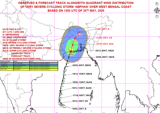
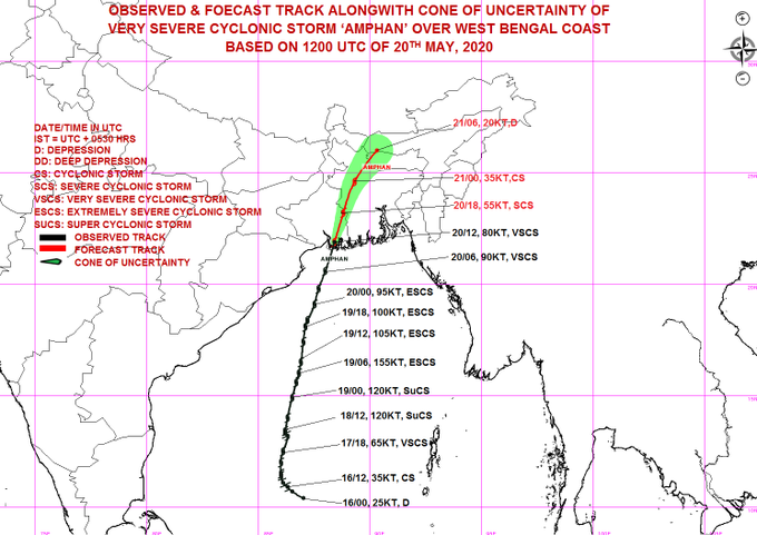
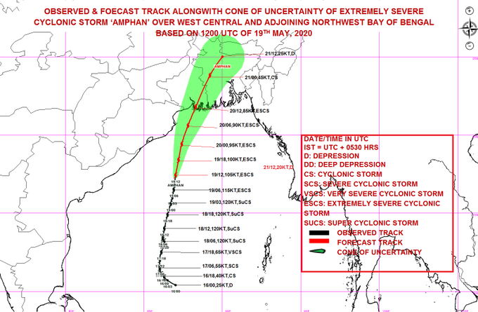
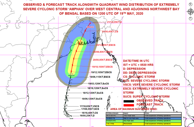
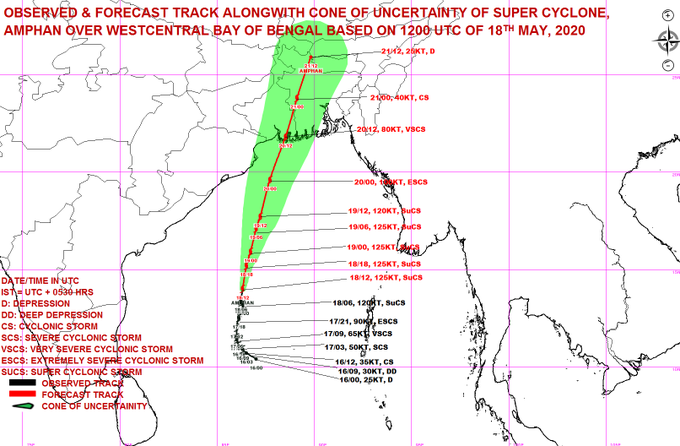
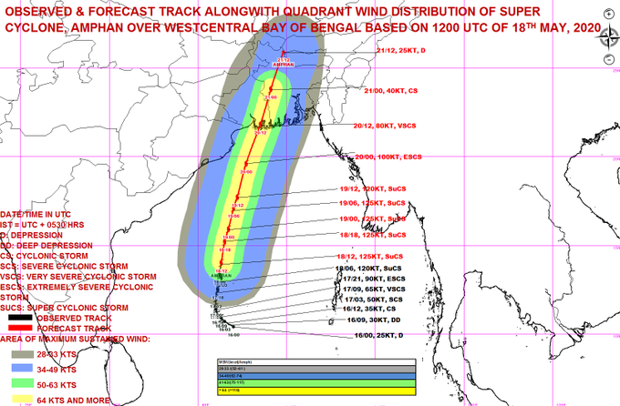
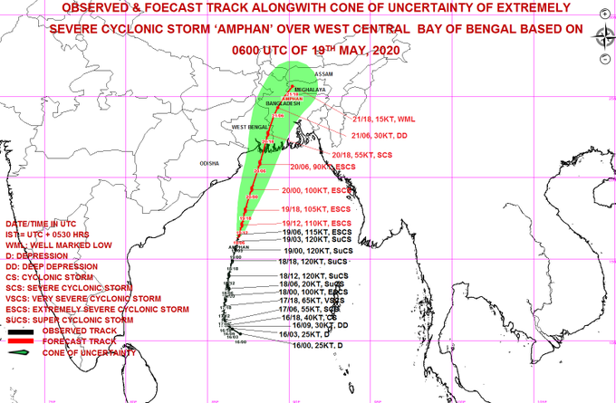
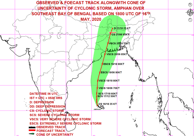
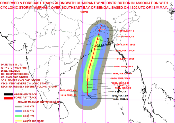
Super Cyclone AMPHAN is likely to make landfall between Digha (West Bengal) and Hatiya Islands (Bangladesh) close to Sundarbans as an Extremely Severe Cyclonic Storm with maximum sustained wind 165-175 kmph gusting to 195 kmph in the afternoon/evening of 20th May.
11
267
600
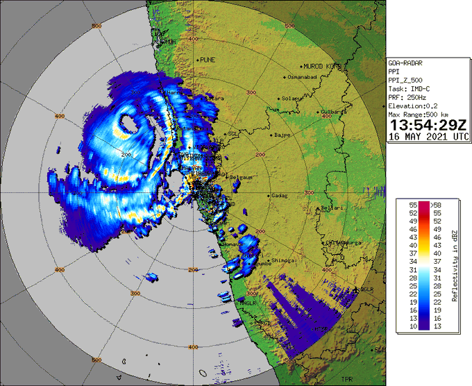
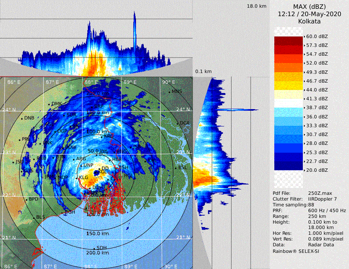
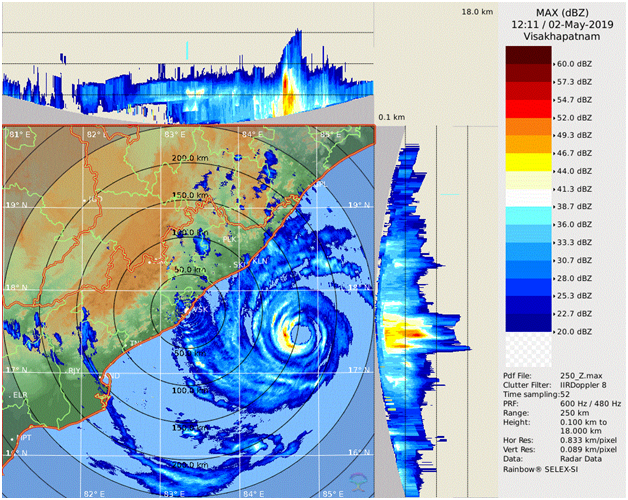
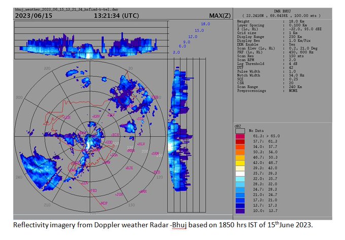
Eye of the cyclone is visible in Radar.
14
85
608
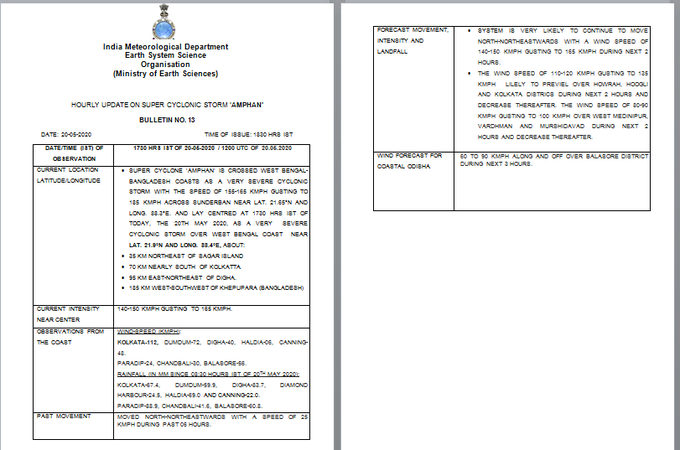
SUPER CYCLONE ‘AMPHAN’ CROSSED WEST BENGAL-BANGLADESH COASTS AS A VERY SEVERE CYCLONIC STORM WITH THE SPEED OF 155-165 KMPH GUSTING TO 185 KMPH ACROSS SUNDERBAN NEAR LAT. 21.65°N AND LONG. 88.3°E. AND LAY CENTRED AT 1930 HRS IST OF TODAY, THE 20TH MAY 2020.
15
151
581
Cyclone Tauktae update 00 IST 18th May 2021
The entire eye of cyclone has now crossed the coast and lies overland. The rear sector of the eyewall is now entering the land.
9
109
585
Cyclone Alert for Saurashtra and Kutch Coast: Yellow Message. ESCS BIPARJOY lay over eastcentral Arabian Sea at 0830 IST today,460 km SSW of Porbandar,510 km SSW of Dwarka,600 km SSW of Naliya. To cross Saurashtra and Kutch and adj Pakistan coasts around noon of 15 June as VSCS.

7
144
587
Congratulations Team India !!! Dr. Mrutyunjay Mohapatra, DG IMD has won the election to the post of Third Vice President of WMO. A resounding Victory (113 out of 148 votes).
@IndraManiPR
@BarkhaTamrakar
@moesgoi

18
77
591
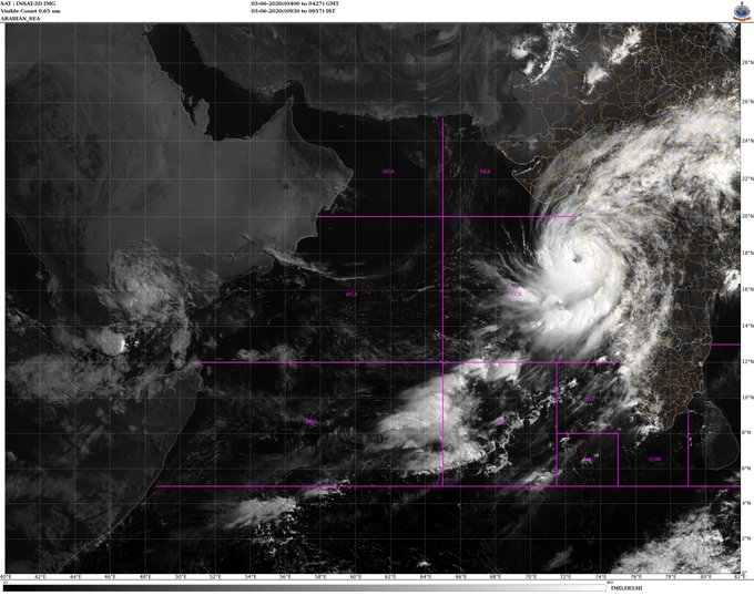
Visible Image INSAT 3D (09:30-09:57 IST) 03-06-2020
Severe Cyclone "NISARGA"
5
155
573
VERY SEVERE CYCLONIC STORM ‘YAAS’ CENTRED ABOUT 40 KM EAST OF DHAMRA AND 90 KM SOUTH-SOUTHEAST OF CROSS NORTH ODISHA-WEST BENGAL COASTS TO THE NORTH OF DHAMRA AND SOUTH OF BALASORE NOON OF 26TH MAY AS A VSCS WITH WIND SPEED OF 130-140 KMPH.

12
151
582
Super Cyclone AMPHAN to cross West Bengal – Bangladesh coasts between Digha (West Bengal) and Hatiya Islands (Bangladesh) close to Sundarbans during afternoon to evening of 20th May 2020 with wind speed of 155-165 kmph gusting to 185 kmph.
17
181
568
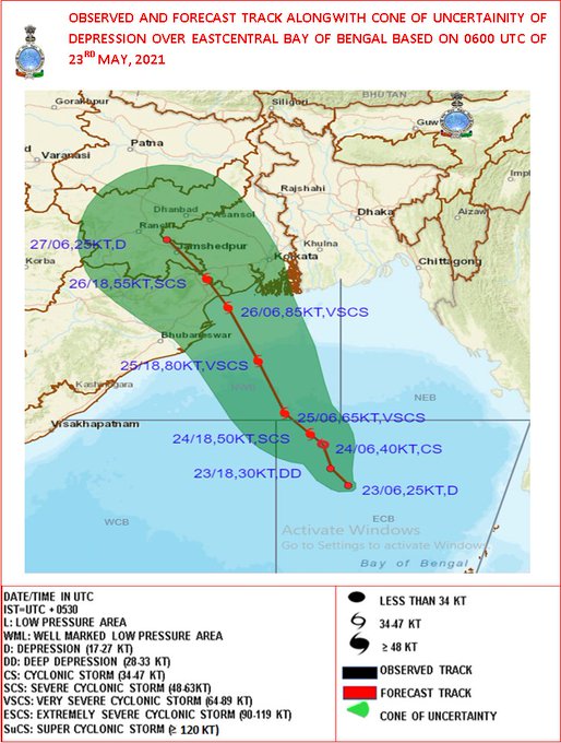
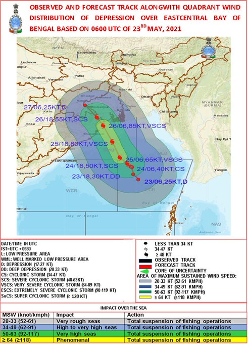
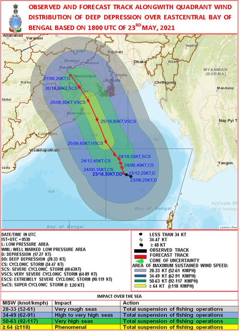
A LOW PRESSURE AREA IS VERY LIKELY TO FORM OVER EASTCENTRAL BOB AND ADJOINING NORTH ANDAMAN SEA AROUND 22ND MAY, 2021. IT IS VERY LIKELY TO INTENSIFY INTO A CYCLONIC STORM BY 24TH. IT IS VERY LIKELY TO MOVE NORTHWESTWARDS AND REACH NEAR ODISHA-WEST BENGAL COASTS BY 26 MAY MORNING
8
118
558
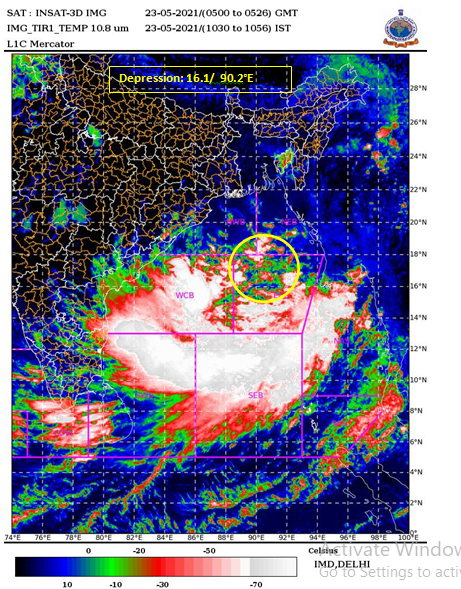
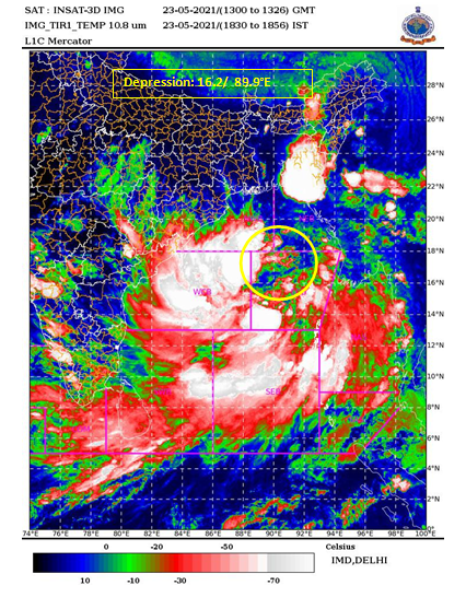
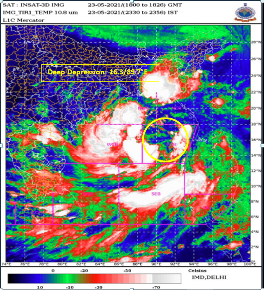
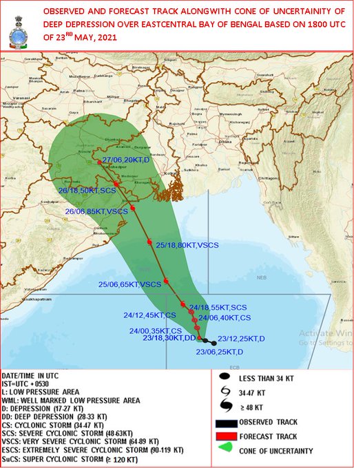
Depression over eastcentral Bay of Bengallay lay centred at 1730 hrs IST of today, the 23rd May, 2021 about 590 km north-northwest of Port Blair. To intensify into a Cyclonic Storm by 24th May morning and further into a Very Severe Cyclonic Storm during the subsequent 24 hrs.
8
138
562
Super Cyclonic Storm ‘AMPHAN’ (pronounced as UM-PUN) : 18th May 2020 (1130 to 1157 IST).
8
101
561
Press Release: Southwest Monsoon has covered entire country including Delhi
16
95
555
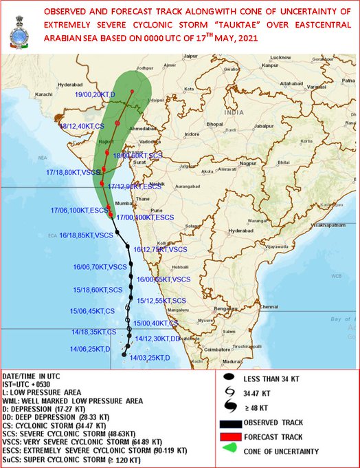
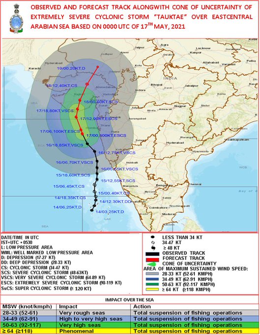
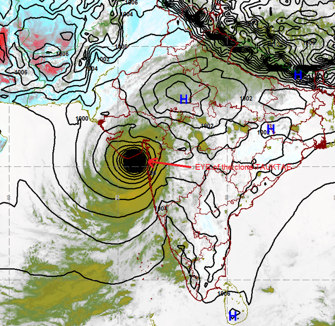
The Very Severe Cyclonic Storm “Tauktae” over eastcentral
Arabian Sea about 190 km northwest of Panjim-Goa, 270 km
south-southwest of Mumbai, 510 km south-southeast of Veraval (Gujarat). It likely to intensify further during next 24 hours.
9
168
554
Cyclone Tauktae
INSAT 3D satellite-based centre position at 2130IST
20.65N & 71.15E about 30kms east of Diu.
The landfall process will continue for next 2hrs.
8
116
547
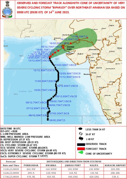
Cyclone Warning for Saurashtra & Kutch Coasts (Red Message) VSCS Biparjoy over Northeast Arabian Sea at 1730 hours IST of today, the 14th June, 2023 about 240 km southwest of Jakhau Port (Gujarat), 260 km west-southwest of Devbhumi Dwarka, 260 km west-southwest of Naliya.
4
89
560
3
71
542
Cyclone Alert for Saurashtra & Kutch Coast: Yellow Message. ESCS BIPARJOY over eastcentral Arabian Sea, at 2330 IST of 11th Jun near lat 18.9N & long 67.7E, Likely to cross between Mandvi (Gujarat) and Karachi (Pakistan) by noon of 15thJune. More details:
2
94
547
Extremely Severe Cyclonic Storm ‘AMPHAN’ with Eye Pattern: 18th May 2020 (0730 to 0750 IST)
13
183
533
VSCS ‘YAAS’ CROSSED NORTH ODISHA COAST ABOUT 20 KM SOUTH OF BALASORE DURING 1030 TO 1130 HOURS IST OF TODAY WITH ESTIMATED WIND SPEED OF 130-140 KMPH GUSTING TO 155 KMPH.THEN MOVED NW-WARDS AND AT 1130 HRS IST,CENTRED NEAR 21.4°N/86.9°E ,ABOUT 15 KM SSW OF BALASORE.
13
118
529
Warm wishes to the 42nd ISEA Wintering Team at
#Maitri
and
#Bharati
in
#Antarctica
! Your resilience and dedication in overcoming polar night challenges embody the true spirit of Antarctic exploration. Your contributions to climate research are invaluable.


3
70
543
VSCS Biparjoy over Northeast Arabian Sea at 0230 hours IST of 15th June, 2023 about 200 km west-southwest of Jakhau Port (Gujarat). To cross Saurashtra & Kutch and adjoining Pakistan coasts between Mandvi and Karachi near Jakhau Port by evening of 15th June as a VSVS.

5
105
530
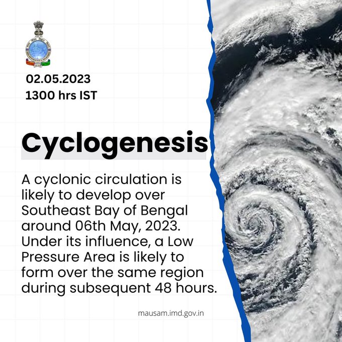
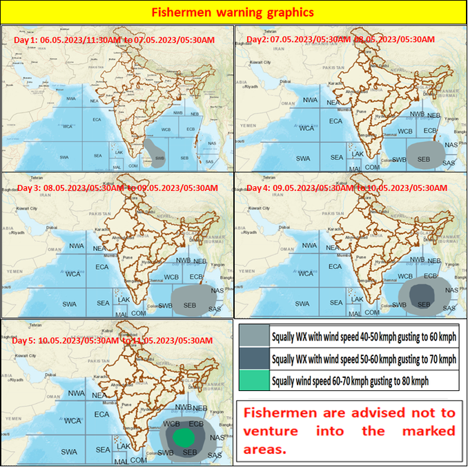
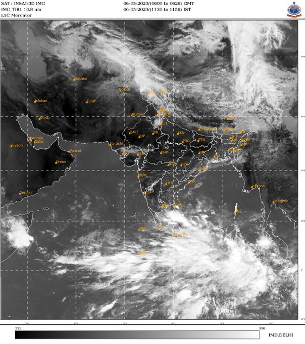
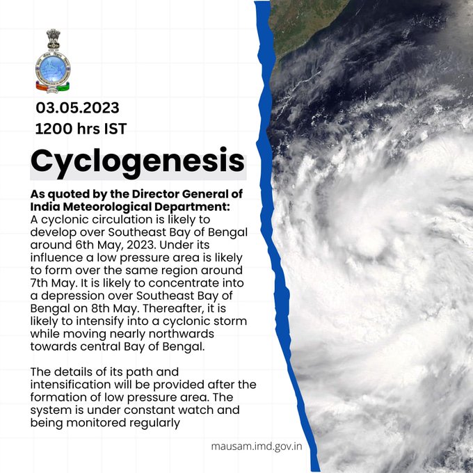
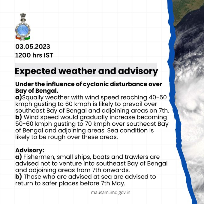
A cyclonic circulation has formed and lay over the southeast Bay of Bengal and neighborhood at 0830 IST of today. LPA is likely to form by 8th May, morning and Depression around 9th May.
Visit for more details.
2
81
538
IMD model with the satellite image has generated by METCAP for the Extremely Severe Cyclonic system TAUKTAE at 1430 hrs IST
12
105
513
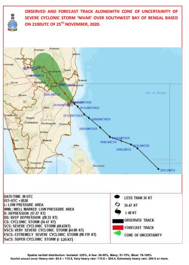
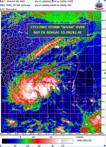
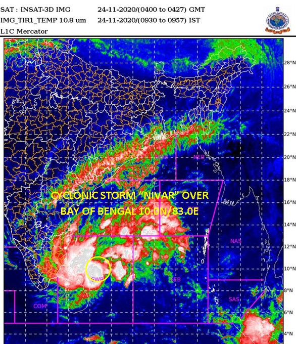
दक्षिण-पश्चिम बंगाल की खाड़ी के ऊपर स्थित चक्रवाती तूफान "निवार" बीते छह घंटे में 05 किमी प्रति घंटे की गति के साथ पश्चिम की ओर बढ़ा और भारतीय समयानुसार आज शाम , 24 नवंबर, 2020, 1730 बजे दक्षिण-पश्चिम बंगाल की खाड़ी में अक्षांश 10.0°N एवं देशान्तर 82.4°E पर केंद्रित है |
717
56
505
To get information about lightning occurrence and its forecast by IMD/MoES in your area, please download:
1. DAMINI app
2. RAIN ALARM app
3. UMANG app
4. MEGHDOOT app
5. MAUSAM app
All the above APPS are available on Android and IOS.
17
121
510
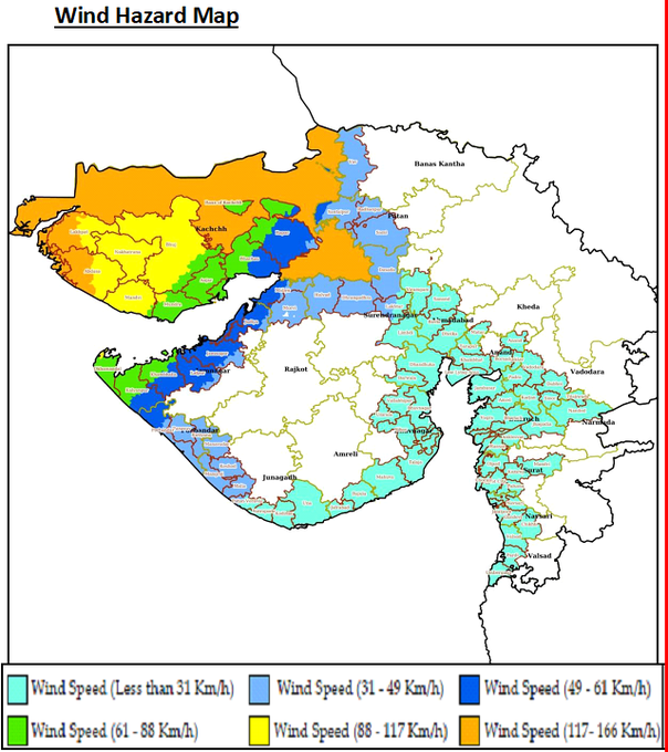
LANDFALL: VSCS BIPARJOY moved northeastwards and CROSSED Saurashtra-Kutch coast near Jakhau Port (Gujarat) between 2230 & 2330 IST of 15th June as a VSCS with windspeed of 115-125 kmph.
4
103
530
Depression over Eastcentral Bay of Bengal intensified into a Deep Depression and about 600 km north-northwest of Port Blair. To intensify into a Cyclonic Storm by 24th May morning and further into a Very Severe Cyclonic Storm during the subsequent 24 hours.
7
94
521
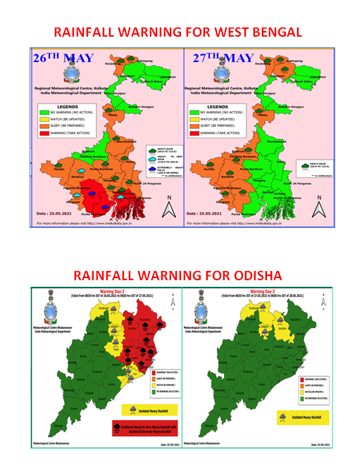
Isolated heavy rainfall likely over Jammu & Kashmir, Ladakh, Gilgit, Baltistan & Muzaffarabad on 05th; Himachal Pradesh on 05th, 07th-09th & Uttarakhand during 07th-19th July.
Isolated heavy to very heavy rainfall over Himachal Pradesh on 06th and Uttarakhand on 05th & 06th July.
14
116
511
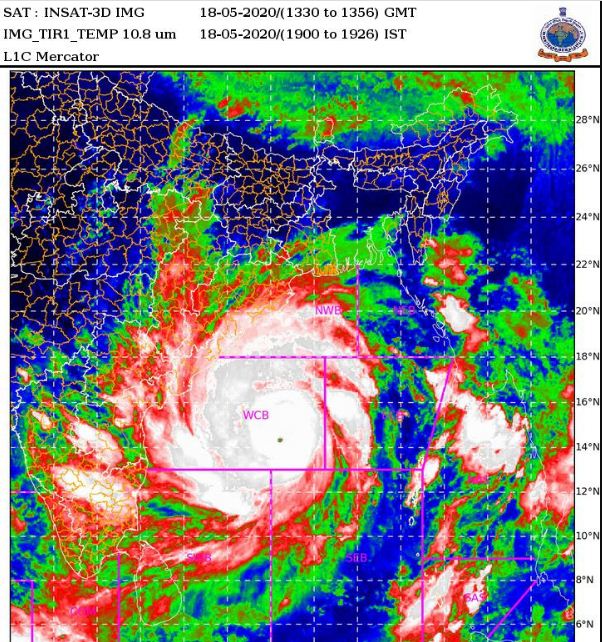
The SUPER CYCLONE ‘AMPHAN’ over west-central Bay of Bengal, lay centered at 1730 hrs IST of today, the 18 th May, 2020 over west-central Bay of Bengal near latitude 14.0°N and longitude 86.3 °E, about 700 km nearly south of Paradip (Odisha).
8
175
503
Extremely Severe Cyclonic Storm Tauktae
INSAT 3D satellite-based centre position
at 1130 IST - 19.2N & 71.5E
Distance from Diu is 182km (South-southeast)
Distance from Mumbai is 142km (west-northwest)
4
121
508
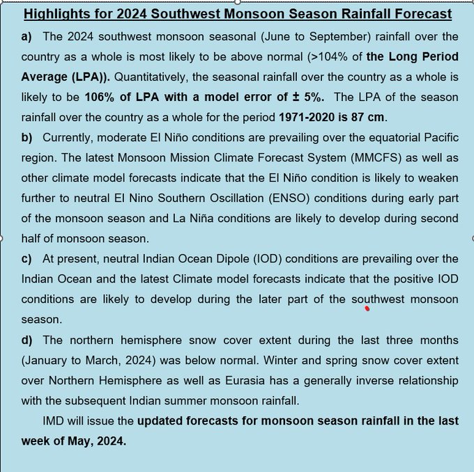
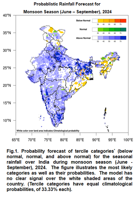
IMD predicts 2024 southwest monsoon season (June to September) rainfall over the country as a whole to be above normal (>104% of the Long Period Average (LPA)). Seasonal rainfall is likely to be 106% of LPA with a model error of ± 5%. LPA of monsoon rainfall (1971-2020) is 87 cm.
15
130
527
THE VERY SEVERE CYCLONIC STORM ‘TAUKTAE’ MOVED NORTH-NORTHEAST WARDS WITH A SPEED OF 11 KMPH DURING PAST 06 HOURS.
10
56
505
AMPHAN crossed West Bengal-Bangladesh coast between Digha (West Bengal) and Hatiya Islands (Bangladesh) across Sunderbans near lat 21.65N & long 88.3E between 1530 & 1730 hrs IST of 20th May with wind speed of 155-165 gusting to 185 kmph.
16
170
506
Heavy to very Heavy rainfall with isolated Extremely Heavy rainfall expected over Coastal Andhra & Yanam, Rayalaseema & Tamil Nadu on 03rd & 04th December.
2
103
514
Cyclone Tauktae update
At 2230 IST - centre of the cyclone now lies overland about 20kms East-northeast of Diu.
The landfall process will continue for next 2hrs.
16
132
501
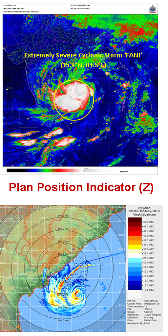
ESCS FANI centered near 17.4 N/84.8E over westcentral Bay of Bengal at 1730 hrs IST about 275 km SSW of Puri & 160 km ESE of Visakhapatnam. To cross Odisha coast between Gopalpur & Chandbali around Puri during forenoon of tomorrow, the 3rd May.

12
340
484
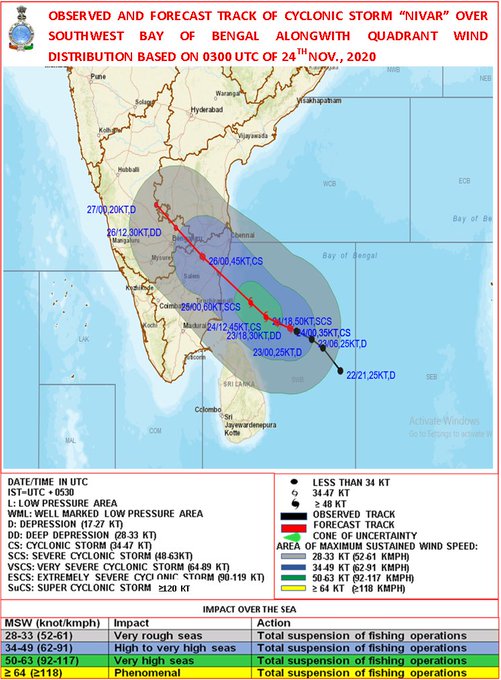
Cyclonic storm 'NIVAR' over Bay of Bengal lay centred at 0830 hrs IST of 24th Nov, about 410 km east-se of Puducherry. To intensify further into a SCS during next 24 hrs. To cross Tamil Nadu and Puducherry coasts during 25th Nov evening as SCS with a wind speed of 100-110 kmph.
9
132
494
Cyclone Warning for Saurashtra and Kutch Coasts: Orange Message. VSCS BIPARJOY at 0830IST of today about 280km SW of Devbhumi Dwarka, 300km WSW of Porbandar, 310km SW of Jakhau Port, 330km SW of Naliya. To cross near Jakhau Port (Gujarat) AROUND evening of 15th June as VSCS.
3
122
507
At 0830 IST, SCS ‘Yaas’ about 280 km south-southeast of Paradip. To intensify further and cross north Odisha-West Bengal coasts between Paradip and Sagar Island close to north of Dhamra and south of Balasore, during noon of Wednesday, the 26th May as a Very Severe Cyclonic Storm.
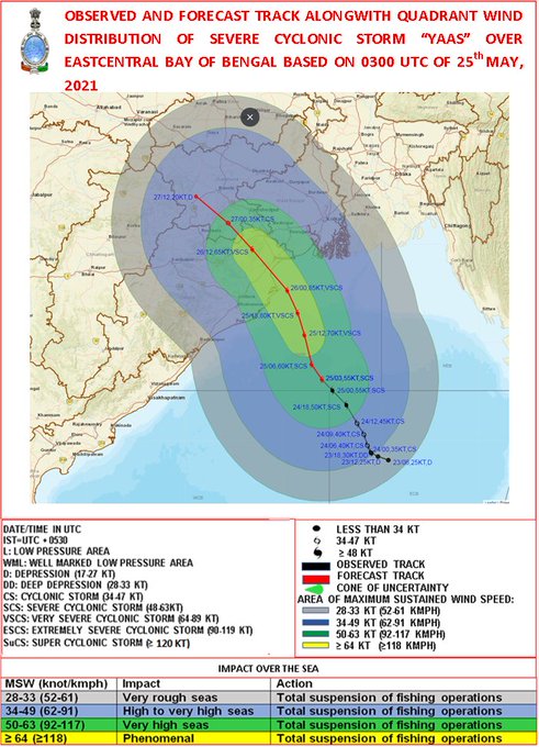
17
115
496
Southwest Monsoon has covered entire country today, the 02nd July 2022.
10
72
499
Super Cyclone AMPHAN to cross West Bengal – Bangladesh coasts between Digha (West Bengal) and Hatiya Islands (Bangladesh) close to Sundarbans during afternoon to evening of 20th May 2020 with wind speed of 155-165 kmph gusting to 185 kmph.
11
175
495
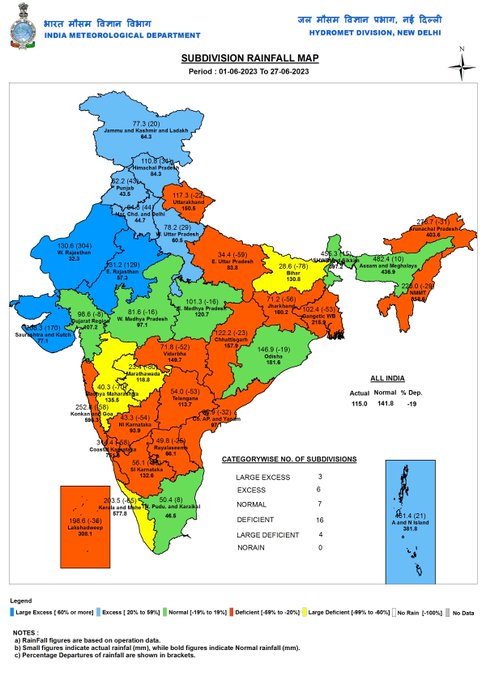
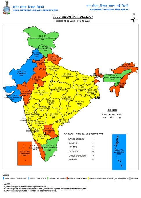
Improvement in the current monsoon Season’s rainfall over India: Monthly cumulative all India rainfall for 1-27 June 2023 over India reached -19%, in terms of % departure from long period average for the same period. It was -51% for the period from 1 June till 15 June 2023.
4
71
507
A low pressure area formed over Southeast & adjoining Eastcentral Arabian Sea and Lakshadweep area. To concentrate into a Depression over Eastcentral and adjoining Southeast Arabian Sea during next 24 hours and into a Cyclonic Storm during the subsequent 24 hours
15
139
495
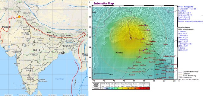
Earthquake of Magnitude:6.3, Occurred on:24-09-2019, 16:31:58 IST, Lat:32.9 N & Long: 73.7 E, Depth: 40 Km, Region: Pakistan - India (J & K ) Border region
23
316
468
Cyclonic Storm likely over Bay of Bengal.
2
77
502
LATEST OBSERVATIONS AT 1030 HRS IST INDICATE THAT THE SYSTEM IS NOW CROSSING COAST TO THE SOUTH OF BALASORE. THE LANDFALL PROCESS WILL TAKE ABOUT 2 HOURS TO COMPLETE.
10
74
492
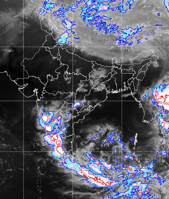
Recent satellite imagery depicts presence of
1. Moderate to intense convection over South Bay of Bengal & Nicobar Islands and south Maharashtra, Karnataka, Tamil Nadu, Andhra Pradesh, Telangana.
2
48
491
Landfall Process of ESCS TAUKTAE CONTINUES.
9
114
485
Cyclonic Storm ‘AMPHAN’ lay over South-East BOB today, the 16th may evening. To intensify into very severe cyclonic storm by 18th morning.
8
164
488
Cyclone Warning for Saurashtra & Kutch Coasts: RED MESSAGE.VSCS BIPARJOY at 1730IST today near lat 22.8N and lon 67.9E about 70km WSW of Jakhau Port (Gujarat),130km WNW of Devbhumi Dwarka. LANDFALL PROCESS HAS COMMENCED.
4
109
494
Cyclone Warning for Saurashtra & Kutch Coasts: RED MESSAGE.VSCS BIPARJOY at 1930IST today near lat 23.0N and lon 68.3E about 40km SW of Jakhau Port (Gujarat),110km NW of Devbhumi Dwarka. LANDFALL PROCESS HAS COMMENCED.
2
89
490
Cyclone Alert for Saurashtra and Kutch Coast: Orange Message. ESCS BIPARJOY lay at 0830IST today, about 320km SW of Porbandar, 360km SSW of Devbhumi Dwarka, 440km South of Jakhau Port, 440km SSW of Naliya. To cross near Jakhau Port (Gujarat) by noon of 15th June as VSCS.
6
111
495
Low pressure area has formed over eastcentral BoB today morning. To intensify into a CS by 24th May. To intensify further into Very Severe Cyclonic Storm, move north-northwestwards and cross West Bengal and adjoining north Odisha & Bangladesh coasts around 26th evening.
14
103
468