

GeoPackage
@GeoPackage1
Followers
2K
Following
734
Media
12
Statuses
539
Talking about all things GeoPackage /Spatialite Not official OGC GeoPackage account.
Joined October 2017
RT @recursecenter: Join us on August 13 for Localhost!. 🦠 @computerender will present Mote, an interactive ecosystem simulation with hundre….
0
175
0
RT @PythonMaps: Few people realise the scale of the Himalayas because static maps are a bad way to convey topography. Fortunately, we can u….
0
1K
0
RT @giswqs: 🚀 Sneak Peek: Interactive Visualization of the Planet Tanager Hyperspectral Data ( Using the HyperCoast….
0
82
0
RT @crunchydata: PostGIS tip: Get faster spatial queries and maps with st_simplfy. ⚡ . When you don't need exact topology and want to make….
0
1
0
RT @RemoteSens_MDPI: 🌳🏙️🌳 Testing the Impact of #Pansharpening Using #PRISMA #Hyperspectral Data: A Case Study Classifying #Urban #Trees in….
0
18
0
RT @garrettkjohnson: I've gotten contour and latitude / longitude lines working with ellipsoidal tile sets in 3D Tiles Renderer - demo link….
0
43
0
RT @crunchydata: Replication from Postgres --> Iceberg demo here. What you're seeing:.- Running a big query is slow, so we'll put our dat….
0
4
0
RT @berttemme: How to migrate from the traditional GDAL command line utilities to the unified "gdal" command line interface added in GDAL 3….
0
5
0
RT @crunchydata: Working on performance tuning for large reports and analytics? This blog is packed with helpful tuning options like using….
0
5
0
RT @grid3global: New #data! V5.0 of our #DRC settlement names, health facilities, #health areas + health zones was produced with @ciesin. I….
0
5
0
RT @geoawesome_dgtl: 🛰️ Looking for high-res satellite imagery?.Here are 10 FREE sources of remote sensing data – NASA, Sentinel, USGS & mo….
0
10
0
RT @CesiumJS: Godot users can now add real-world 3D geospatial data to @godotengine projects—and it's simple. Check out @BattleRoadDigi's….
0
2
0
RT @CesiumJS: We're excited to announce the release of 3D Tiles for Godot, an open source plugin for @godotengine, built by @BattleRoadDigi….
0
8
0
RT @mapserving: sharing a great event for your #foss4g calendars (and notice the new logo!) . .
0
1
0
RT @RemoteSens_MDPI: 🌾🌾 Estimation of #Rice Plant Coverage Using #Sentinel2 Based on #UAV-Observed #Data. ✍️ Yuki Sato et al. 🔗 https://t.c….
0
10
0
RT @PythonMaps: I had the privilege of working with @SynMaxInt to generate this map of global fishing. They’re doing cool things over there….
0
4
0
RT @Hydrology_mdpi: #EditorChoice.Spatial Evaluation of a Hydrological Model on Dominant Runoff Generation Processes Using Soil Hydrologic….
0
13
0

RT @planetpostgres: Lukas Fittl (@LukasFittl): Postgres vs. SQL Server: B-Tree Index Differences & the Benefit of Deduplication https://t.c….
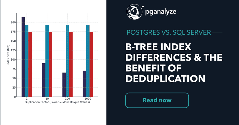
pganalyze.com
Discover how PostgreSQL and SQL Server—including Azure SQL—differ in their B-Tree index implementations, storage behavior, and performance impact. Includes benchmarks, deduplication analysis, and a...
0
14
0