
Esri Public Safety
@GISPublicSafety
Followers
11K
Following
4K
Media
3K
Statuses
6K
Discover the power of ArcGIS to manage emergencies and the flow of public information.
Joined July 2009
Improve safety and decision-making with a full suite of wildfire layers. Track active fires, view MODIS and VIIRS satellite heat detections, and overlay critical smoke forecasts and weather outlooks. #GIS #WildlandFire. Read the article:

0
0
1
Discover how GIS technology enables data-driven decision-making by mapping community risks, optimizing resource deployment, and assisting with the accreditation process. #EsriPublicSafety #webinar. Register Today:

0
0
0
NIFC’s ArcGIS Online org keeps teams on the same schema, symbology, and data, whether you’re initial attack or Type 1. Learn how this single source of truth streamlines ops and boosts awareness. Read the article: #WildlandFire #GISinAction @NIFC_Fire

0
0
0
Learn how the US Fire Administration is using the geographic approach in their Home Fire Fatalities Explorer application – available to help users understand the vulnerabilities related to home fire fatalities. #EsriPublicSafety #webinar. Register Today:

0
1
3
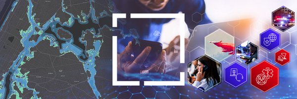
Global events are complex. GIS delivers real-time situational awareness, multiagency coordination, and predictive insights for critical venues—helping teams plan, monitor, and respond with clarity. #PublicSafety #GIS #EventSecurity #ArcGIS

0
0
0
Wildfire season demands fast answers. This article highlights key tools to help firefighters, managers, and emergency teams stay informed and act with confidence. #Wildfire #PublicSafety #GIS #SituationalAwareness

0
0
0
The Port of Corpus Christi, a top energy port in the Americas, now features a digital twin using multi-source geospatial data and high-res imagery to model and analyze its complex infrastructure. Learn more about this advanced system here:

0
0
0
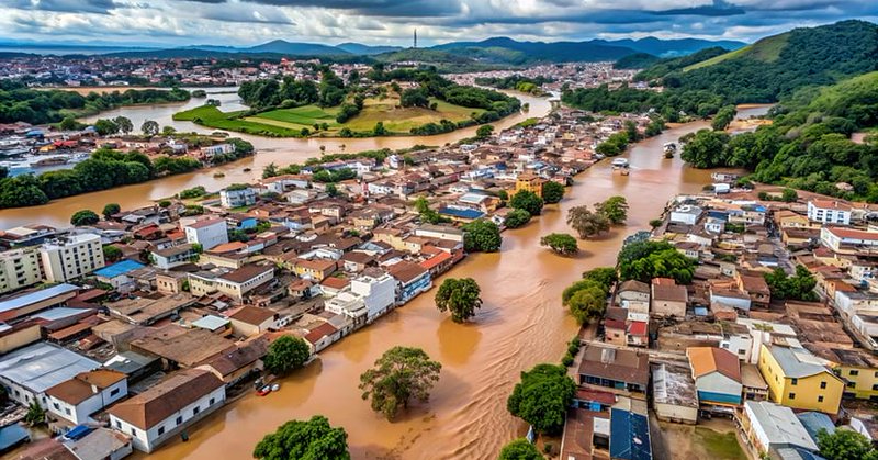
In May 2024, a historic flood hit Porto Alegre. Codex built 17 GIS apps in 30 days to support response efforts. Despite personal losses, their team turned hardship into purpose with real-time mapping.
esri.com
When historic floods hit Brazil, GIS company Codex turned personal tragedy into purpose, creating 17 apps in 30 days to guide rescuers.
0
0
0
Understand your wildland-urban interface! Join us as we discuss the evolution of wildland-urban interface awareness applications, showcase their use and latest features, and share the vision for their future. #EsriPublicSafety #webinar. Register Today:

0
0
0
Learn how the US Fire Administration is using the geographic approach in their Home Fire Fatalities Explorer application – available to help users understand the vulnerabilities related to home fire fatalities. #EsriPublicSafety #webinar. Register Today:

0
0
0
Collaborate with colleagues, technical experts, solution providers, & peers from the safety & security sector. Share innovative ideas & experiences & learn from best practices to identify threats & build resilience within your community. Register: #E2NS2

0
0
0
Tired of wildfire policy reports that sit on a shelf? The new Alliance tracker maps real legislation to Fire Mitigation Commission recommendations. See what’s working—and what needs help. #WildfirePolicy #GIS #FireResilience #LegislationTracker

0
0
0
Fraud, waste, and abuse all happen in places—and GIS shows where. This paper explains how spatial analytics, imagery, and dashboards give agencies the edge to prevent loss and build accountability. #GIS #FraudPrevention #PublicAccountability

0
0
0
A historic May 2024 flood struck Porto Alegre. Codex responded by creating 17 GIS apps in 30 days. Amid personal losses, the team used real-time mapping to aid rescue efforts and find purpose in the crisis. Read more:
esri.com
When historic floods hit Brazil, GIS company Codex turned personal tragedy into purpose, creating 17 apps in 30 days to guide rescuers.
0
0
0
To ensure a coordinated effort during the aftermath of Hurricane Helene, the @NCNationalGuard relied on GIS technology to streamline recovery and enhance collaboration among all responding agencies. Read more on their approach:

0
1
3
Discover how GIS technology enables data-driven decision-making by mapping community risks, optimizing resource deployment, and assisting with the accreditation process. #EsriPublicSafety #webinar. Register Today:

0
0
0
Understand your wildland-urban interface! Join us as we discuss the evolution of wildland-urban interface awareness applications, showcase their use and latest features, and share the vision for their future. #EsriPublicSafety #webinar. Register Today:

0
0
0
With live feeds from IRWIN and NIFC, the USA Current Wildfires layer gives you up-to-date fire information without extra setup. Bring reliable situational awareness into the field with tools that work where you work. #GIS #WildlandFire. Read the article:

0
0
0
In May 2024, a historic flood hit Porto Alegre. Codex built 17 GIS apps in 30 days to support response efforts. Despite personal losses, their team turned hardship into purpose with real-time mapping.
esri.com
When historic floods hit Brazil, GIS company Codex turned personal tragedy into purpose, creating 17 apps in 30 days to guide rescuers.
0
0
0
Stop wrestling with field names. The National Incident Feature Service, structure-triage layer, and turnkey map templates in NIFC’s ArcGIS Online org let you focus on analysis, not data wrangling. Read the article: #WildlandFire #GISinAction @NIFC_Fire

0
0
1