
EarthScope Consortium
@EarthScope_sci
Followers
57K
Following
21K
Media
9K
Statuses
30K
EarthScope Consortium is a new organization formed by the merger of UNAVCO and IRIS. Operator of the NSF GAGE and NSF SAGE Facilities. #NSFfunded
Joined June 2009
Want to stay up to date on the latest posts from EarthScope? Stay connected by finding us in the blue skies—search for EarthScope Consortium on your favorite platforms.
3
0
7
Make sure you don't miss out on new posts from EarthScope! Please follow us on any of our other social platforms to stay connected in the future. ➡️ https://t.co/zGMgWLIKmr
0
1
8
This #FieldworkFriday is brought to you from the picturesque views of station P183 on Bodega Head in CA. This Network of the Americas station sits on the Pacific Plate just west of the San Andreas Fault and records motion 40 mm/yr to the northwest. 📷 Doerte Mann/EarthScope
0
5
17
We're hiring a Systems Administrator III (remote, US) to help take the lead in shaping our IT infrastructure. If you're experienced in cloud environments, cybersecurity, and network engineering, this is your chance to make an impact! Learn more & apply: https://t.co/aeRFepKavm
0
1
9
Explore more with our Interactive Earthquake Browser https://t.co/OM7bvJKw7W
0
1
8
🔎 Where do the world's largest earthquakes occur? This map shows 5,000 earthquakes magnitude 6 and greater, colored by depth. Notice anything interesting? Most of the strongest quakes cluster along tectonic plate boundaries. What patterns stand out to you?
4
30
80
WEBINAR RECORDING Seafloor Geodesy and the Hunt for Shallow Slip in Cascadia Presented by Dr. Noel Bartlow, University of Kansas https://t.co/HraDT7dsnc
0
4
12
Discover the details of our planet's interior with "What's Inside the Earth?" This interactive poster links to videos and apps where you can view real seismic data, making it a practical tool for connecting classroom concepts with real-world examples. https://t.co/4LZX9kIIez
1
44
106
GPS station AC03 in Anchor Point, part of the Network of the Americas, helps capture this motion. It reveals decades of vertical uplift, reflecting the ongoing reshaping of Alaska’s landscape.
0
0
6
The 1964 Great Alaska Earthquake caused the Kenai Peninsula to subside, and the land today is still bounding back after the earthquake. Meanwhile, centuries of ice loss have lightened the load on the crust, allowing it to spring back.
1
2
5
Alaska is on the rise—literally. 🛰️📈 GPS data reveal that parts of the Kenai Peninsula are steadily rising, a lingering response to both tectonic and glacial forces.
1
11
19
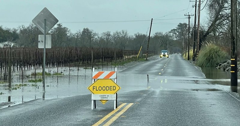
In 2023, atmospheric rivers dumped tons of precipitation on California. While the green vegetation and flooding was obvious, it’s not quite so easy to track how this affected groundwater. A recent paper shows how seismometers can help measure that! ⬇️ https://t.co/0K9OS566NY
earthscope.org
In early 2023, an incredible amount of precipitation fell on drought-stricken California. The surface effects were quite visible but it’s not quite so easy to track how this affected groundwater.
0
2
5
Check out how discoveries from the EarthScope program (2003-2018) have transformed our knowledge of Alaskan tectonics!

New seismic data are reshaping what we know about #tectonics in #Alaska and #NorthwesternCanada. Dr. Natalia Ruppert, Dr. Margarete Jadamec, and Dr. Jeffrey Freymueller discuss key discoveries from their new book. 📚 🎥 Watch now: https://t.co/PnlSzooWCb
@wileyearthspace
0
1
1
By making high-quality geophysical data openly available, NSF SAGE Data Services empowers researchers, educators, and decision-makers to advance our understanding of Earth's dynamic systems, improve hazard preparedness, and drive innovation in geoscience.
1
0
3
NSF SAGE Data Services is the world’s largest facility for the archiving, curation, and distribution of seismological and other geophysical research data and data products.
1
1
11
How much bigger is a magnitude 8 earthquake compared to a magnitude 6? A LOT bigger. For each whole magnitude number, the energy released increases by a factor of 32. Check out this cool visualization that puts earthquake magnitudes in perspectives. https://t.co/vqsuSiIYuw
1
5
14
From the core to the crust, we’re feeling the geophysical love this Valentine’s Day ❤️🌎
0
4
8
UPCOMING WEBINAR Seafloor geodesy and the hunt for shallow slip in Cascadia Presenter: Dr. Noel Jackson, University of Kansas Thursday, February 20 at 2 pm ET, Virtual Register: https://t.co/Hpxc67KLmO
0
1
6
⏳ Don’t Miss Out! RESESS, Geo-Launchpad, & Student Career Internship Applications Close This Weekend! Our internship applications close February 15 at 11:59 PM (Eastern)—don't miss your chance to gain hands-on experience in geoscience and beyond! Apply:
earthscope.org
EarthScope offers a variety of paid summer internships in geoscience, ranging from research skill development to professional work experience.
There's two weeks left to submit an application to one of our summer internship programs! Apply by February 15 for: 🔬Geo-Launchpad 🧑🔬 RESESS 📊 Student Career Internship Program ➡️ https://t.co/Bwmbbcj2T2
1
0
1
NEW 📚 EDUCATOR RESOURCE ShakeAlert: GPS and Slow Extension Across the Basin and Range Province This interactive activity helps learners explore GPS data, rock elasticity, and seismic hazards in regions like the Basin and Range Province. ➡️ https://t.co/Q2VrDqsXs1
0
12
32