

Donovan Johnson
@Donovan_J19
Followers
3,476
Following
68
Media
1,536
Statuses
3,996
21 🍻 Updraft enjoyer 🌪, fire photographer 🔥, reporter at WatchDuty 👨💻. Reporting on fires in the central Sierras. Capturing the beauty and fury of NorCal
Auburn, CA
Joined November 2020
Don't wanna be here?
Send us removal request.
Explore trending content on Musk Viewer
#父の日
• 146897 Tweets
#عيد_الاضحي
• 141427 Tweets
Tank
• 118880 Tweets
Dudu
• 108389 Tweets
صالح الاعمال
• 90339 Tweets
Benavidez
• 85023 Tweets
Bucaramanga
• 80276 Tweets
Eid Mubarak
• 70696 Tweets
#FathersDay
• 62483 Tweets
Puello
• 53156 Tweets
Santa Fe
• 41048 Tweets
Oilers
• 38576 Tweets
عيد سعيد
• 30083 Tweets
BINI SPOTIFY TOP ARTIST
• 28692 Tweets
Panthers
• 25230 Tweets
O Fluminense
• 24948 Tweets
Edmonton
• 23654 Tweets
Carti
• 19835 Tweets
Diniz
• 18082 Tweets
Maracanã
• 15723 Tweets
Felipe Melo
• 13210 Tweets
Bryson
• 12793 Tweets
Dudamel
• 12440 Tweets
Bucaros
• 12386 Tweets
#Shinri3D
• 10324 Tweets


Pinned Tweet

I'll still hang around for any weather updates, but expect posts from me to stop or significantly decrease. You can find me over on Threads where I'll be posting regularly. Take care everyone!

0
0
4
Models are now in agreement on a Pacific jet aimed at California bringing a fire hose of rain. These will be mild atmospheric river systems with high snow levels and drenching rain. Flooding concerns are very high, especially with the size of mid-elevation snowpack, the milder


40
159
936
20
162
815

The fire is going nuclear right now. Extreme fire behavior driving impressive plume growth. Looks like a huge thunderstorm or volcano eruption. Unreal. I have no words
#Mosquitofire
#cawx
#firewx

19
192
727
You might want to save this picture folks. Because I doubt we will ever see a model run like this again. The Euro model plasters the sierra foothills with a staggering 20" of snow down to 1,500 feet and has up to an inch in the central valley. Highly unlikely but spectacular eye

24
56
483
WOW! Had a brief tornado touchdown 10 miles east of Farmington. What a day. Video is on my camera but I got a picture of the funnel afterward on my phone
@NWSSacramento
#cawx
#winterwx
#wxtwitter
#tornado


13
122
468
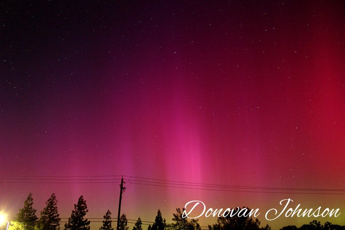
Some edited shots from my camera. What a night. I would've never thought my first aurora sighting would be in California
#cawx
#northernlights
#aurora
#springwx


15
45
372
Good morning, some final edited pictures from the fire. Thinking about going back today
#mosquitofire
#cawx
#firewx


6
45
343
Good morning, Plumas hotshots using fire grenades to conduct a backburn. They create a shower of sparks that lights the vegetation around them
#mosquitofire
#cawx
#firewx
10
35
279
A tornado occurred about an hour ago over populated areas near Montebello, CA. Radar shows a mini supercell with a couplet near Montebello at that time. Wowza
#cawx
#springwx
#tornado
#wxtwitter
#montebello


9
87
252
19
72
245
Big news, I'm now a reporter at
@watchdutyapp
! This means I'll be able to create and update incidents in the app. Excited to continue to serve the Sierra foothills with fire info. If you haven't downloaded the app already, please do! You'll see my reports around
#cawx
#firewx
15
17
219
Aurora watch: A strong (M9.8) solar flare occurred on the sun a few hours ago, releasing a CME (Coronal Mass Ejection) squarely toward earth. It is modeled to hit on the 30th and could cause auroras in mid latitudes, including California. Stay tuned 👀
#solarflare
#northernlights
6
52
212
Satellite imagery shows the strong AR knocking on our doorstep. This will bring warmer temperatures, flooding rains, and thunderstorms over the next few days. The plume of moisture is over 2,000 miles long. Tonight looks very stormy on the latest HRRR runs. Prepare for lightning


10
19
198
6
23
173
A heatwave is brewing to impact us this weekend. Temps will be 10-15° above average and widespread highs in the low to mid 90s are likely. Models hinting at a possible early season monsoon surge early next week that could bring muggy conditions and thunderstorms. Too far out for


5
43
169
Made it home. Give me about an hour to download footage then edit it. Meanwhile here's some edited shots I got
#cawx
#winterwx
#wxtwitter
#storm


4
15
166
Just left the
#ricesfire
with
@MichaelWX18
. Intense scenes with torching and intermittent crowning. This is the head as it went by us earlier
#firewx
#cawx
7
29
142
DC10 dropping on the
#ricesfire
just before we left. Still recovering from it. My first fire and it's a big one
#firewx
#cawx
6
20
138


9
28
139

Intense lightning just occurred right over my house. The brightest flashes and loudest thunder I've ever seen and heard by far from strikes mapped as close as 0.7 miles from me. Insane
#cawx
#wxtwitter
#BombCyclone
#lightning


6
22
135
Back home and I'll show pictures and video in the morning. Protection of Foresthill seems to be going good so far and an inversion sat over the fire all day reducing fire activity
#mosquitofire
#cawx
#firewx

3
10
133
Well it was fun while it lasted but an eastern shift was almost guaranteed. ICON was amazing for storms this past winter and shows a more eastern track. Northern California looks to miss out on any rain. Same can't be said about southern California though
#cawx
#wxtwitter
#hilary

16
20
132
2
12
134
Two large fires blowing up in Southern California currently. They both are producing pyrocumulus clouds and are spreading rapidly. Hopefully not a sign of what's to come for Nor-Cal once the heatwave makes it up here
#routefire
#border32fire
#cawx
#firewx


7
39
133
We are waiting in the Tram building for the PIO to show up and give us an update. S&R seems to be wrapping up operations
#cawx
#winterwx
#avalanche
4
15
135
Taking a breather. What a rush. I have so much footage to go through today. Just an amazing chase day. I got slammed by the RFD after the tornado lifted and it became rain wrapped. Plus the chase terrain wasn't favorable so I decided to ditch the storm. It is now tornado warned

5
12
122
Models have backed off of a significant warm-up and now show us only getting to around average for a few days but it's warmer than the below average temps we've been getting for so long. Temperatures in the upper-60s are expected next weekend under a brief ridge. Euro still wants


5
6
123

3
14
121


It was so cool to see the Chinooks so up close. The beat of the propeller just rocks you to the core. I'll make a full video montage and have it up tomorrow afternoon
#ElectraFire
#firewx
#cawx
2
11
112
Just got off the fire. Man it's intense. Thread with my best photos and video to follow. I'm worn out from being on the fire all day
#mosquitofire
#cawx
#firewx
5
5
110
Came back here to post this. The most amazing thing I've ever seen. Naked eye pillars with reds and greens. Amazing
#cawx
#Auroraborealis
#NorthernLights
5
8
109
NWS Sacramento has just upgraded the Winter Storm Watch to a Winter Storm Warning for motherlode communities from Wednesday morning to Saturday morning. 2-8" at 1,000-1,500 feet, 1'-2' at 1,500 to 3,000 feet is expected. This will cause significant travel delays and widespread


3
21
107
My view from Auburn 20 miles away. Fire activity has picked up significantly. Large plume has developed. 50 acres now and fire intensity is picking up fast. You do not want to be in the path of this thing
#mosquitofire
#cawx
#firewx

9
23
106


2
9
108
2
9
109
3
15
105
Models have been downtrending on the monsoon-like moisture surge early next week. Looks like scattered t-storms are possible along the sierra crest at times with a couple tenths of an inch of precip and no new snow expected. Temps look to remain 10-15° above average for the


3
9
103

Being at this fire has been one of the greatest experiences of my life. I've never been so scared, worried, shocked, and in awe at the same time. I'm so grateful to be able to get this close to the flames and I'm glad to share my experiences with everyone
#mosquitofire
#firewx

3
3
102
After a cool but mostly dry system coming through at the beginning of the week we look to dry out and warm up under high pressure ridging. Temps look to get into the mid-60s to lower-70s later this week and it'll finally start to feel like spring around here. The snowpack will


4
9
101
Good morning! Today is Chase Day with a tornado driven slight risk of severe weather in the central valley. All hazards including tornadoes, severe hail, and severe wind are possible. Will be targeting north of Sacramento for the treat of supercells and tornadoes
#cawx
#wxtwitter


9
13
100
After a short break our next system is on its way for this weekend. Another cool system but not as potent as previous systems. It's effects will be drawn out over several days with multiple waves moving through and showers in between them. Snow levels currently look to be around


3
7
100
Been an active day fire wise in Norcal today. 19 new incidents covered by
@watchdutyapp
amounting to around 160 acres, including 3 10+ acre fires. A sign that fire season is near and it doesn't take much dryness to make conditions favorable for fire spread
#cawx
#firewx
#springwx


6
27
93
I'll be livestreaming the press conference on the Palisades avalanche at 1:30pm
#cawx
#winterwx
#avalanche

3
9
95
A rare hurricane force wind warning has been issued for the Big Sur coast for 40-50 knot (46-57 mph) winds with gusts up to 75 knots (86 mph) and 19-24 foot seas
#cawx
#winterwx
#AtmosphericRiver


2
29
94

Our next system is on the way as another potent bomb cyclone but unlike the last one it will be weakening as it approaches California. Wind gusts up to 40 mph and .5-1.5" of rain is expected. Snow levels will be around 3,000 feet and 1-3 feet of snow is expected in the Sierra.


2
11
89
4
12
92

1
9
88
The calm before the storm.
@MichaelWX18
and I decided to head up early and stay the night so we don't have to worry about the highway shutting down before we get here
#cawx
#winterwx

5
3
91
Plumas hotshots doing backburning on Chicken Hawk road. Now back in Foresthill
#mosquitofire
#cawx
#firewx


3
7
88
7
7
90
Before I return to my hiatus, here's a timelapse of the night. Dancing naked eye pillars galore!
#cawx
#aurora
#NorthernLights
3
11
89
1
8
88
Another strong storm is inbound and will start impacting the state Sunday. This will be a very wet system with a deep subtropical tap. An additional 2-5" of rain will fall. The big worry is So-Cal, which could receive an additional 4-6+" on top of today
#cawx
#winterwx
#wxtwitter

7
12
86

3
7
85
5
8
84
Impromptu snowchase activated! Heavy wet snow starting to accumulate at the Meadow Vista exit (1,600 feet). Wowza!
#cawx
#snow
#bombcyclone
9
9
82
Very tired after this crazy day. Did not expect what happened today at all. Just a few dudes going up to chase the snow suddenly trying our hand at live reporting on a rapidly developing situation. At any rate, I think
@MichaelWX18
and I did pretty good!
5
1
82
Goodnight, I leave you with a edited photo of the massive flames from the group torching that occurred the first day. Thinking about going back tomorrow but not 100% sure
#mosquitofire
#cawx
#firewx

2
4
78
1
11
80
I-80 is now shutdown due to whiteout conditions and wind. We made it to Boreal and will hangout here for a bit
#cawx
#winterwx
#snowstorm
5
14
79
Made it home. The storm was racing north and we couldn't keep up with it. Here's some photos of it going over us and the whales mouth
#cawx
#springwx
#wxtwitter
#storm


1
6
79
Today was just a teaser for tonight. The low pressure system will drop along the California coast and bring significant foothill snow above 500-1,000 feet and some snow in the northern Sacramento Valley north of about Yuba City. Other central valley areas will be too warm due to

4
6
74
Testing out black and white on some of my photos and... I think I kinda like this
#photography
#cawx
#firewx


3
8
74
FEET of snow is going to fall in the mountains with our next system Sunday morning - Monday. Up to 6 feet of snow could fall in the southern Sierra and 3-4 feet expected in the north.
@MichaelWX18
and I will be covering this major winter storm
#cawx
#winterwx
#snowstorm

4
15
75
There is very bad damage in Greenfield, Iowa. My heart goes out to people who have lost homes today. This is the first time I've ever seen tornado damage, and it isn't pretty. We helped people clean debris for a couple hours
#iawx
#wxtwitter


8
17
75
Change of plans today. Gonna be chasing supercells again in the Merced-Fresno area with
@MichaelWX18
and
@US_Stormwatch
. Dynamics look even better than yesterday. Should be interesting! Second chase of this already crazy spring
#cawx
#springwx
#wxtwitter


5
9
72
Some Chinooks dipping in lake Tabeaud. Heading home now and more footage on the way
#electrafire
#cawx
#firewx


1
8
70
I still have footage to go through from yesterday and I won't have time to go through it today but in the meantime here's some more edited shots
#cawx
#wxtwitter


2
12
72
Right now the western flank isn't too active so I feel semi fine logging off for the night. Anything can change as those winds pick up. Hopefully it won't make a run overnight. Night everyone ill be back at it again tomorrow
#caldorfire
7
3
73
Based on some supportive comments I'll be taking a much needed break for the rest of this afternoon. My reports would continue to dwindle and so would my health. Be sure to follow
@jerichoisland
and
@SaltyProg
for the time being as they are superb. I'll be back
#caldorfire
10
1
74
I'd like to announce I've started an internship with
@watchdutyapp
! I'm really excited about this and I think this app has a lot of potential. Be sure to download the Watch Duty app for fire coverage across the state!
#cawx
#firewx
9
8
72
Heading out now. Bringing a gallon of water with me. It's gonna be a long hot day
#mosquitofire
#cawx
#fire
3
4
71
5
17
73
With the tornado threat tomorrow, we need to discuss safety measures. Most people in California do not have a tornado shelter because of how rare they are. If you're under a tornado warning, go to your basement or the most interior room in your home
#cawx
#wxtwitter
#tornado

5
26
71
Hurricane
#hilary
is now a major hurricane at Category 3 strength. With winds estimated at 120 mph, the rapid intensification process is well underway. She's expected to peak at a 140 mph Cat 4 storm by this time tomorrow before weakening afterward
#cawx
#wxtwitter


3
9
72
Currently, over 900,000 customers are without power in California, with over half of Santa Clara County without power. Wicked winds have been snapping power lines and many trees
#cawx
#winterwx
#AtmosphericRiver

1
24
72

The cause? A NCFR suddenly developed inside the frontal rain band. These are narrow areas of heavy rain and are convective so they are able to produce lightning. This amount was a surprise by me. 500+ lightning strikes have been mapped so far
#cawx
#bombcyclone
#lightning
3
16
66

2
5
71
Northern California fire season decided to wake up today. Tens of lightning fires started overnight and are straining air and ground resources. Download the Watch Duty app to keep up to date as we try to unpack all of the information
#cawx
#firewx
#wxtwitter


2
29
70
Hurricane
#Hilary
is now a 125 mph Category 3 storm. She's starting to unravel as she runs into cooler waters and higher shear. The track has been slowly creeping east so she'll probably make landfall in far northern Baja where she'll continue to weaken rapidly
#cawx
#wxtwitter


3
17
67


Finally made it home. I'm going to go straight to bed and spend all day tomorrow going through footage and editing and tweeting it out. I have so many lightning shots I can't wait to share. Literally felt like we were in the plains all day
#cawx
#wxtwitter
#winterwx


2
1
68