DicksonSevereWx
@DicksonSevereWx
Followers
4,212
Following
103
Media
3,517
Statuses
11,733
Severe weather nowcasting for Dickson Co TN. @NWSNashville VERIFIED #tspotter coordinator. NOAA WRN Ambassador. NWS Distinguished Service Award Recipient 2017.
Bon Aqua, TN
Joined February 2012
Don't wanna be here?
Send us removal request.
Explore trending content on Musk Viewer
#Comebacktome
• 667790 Tweets
#RightPlaceWrongPerson
• 421714 Tweets
namjoon
• 301146 Tweets
#LoseMyBreath
• 257548 Tweets
メイドの日
• 127920 Tweets
भगवान परशुराम
• 93109 Tweets
Luka
• 83415 Tweets
#ดวงใจเทวพรหมSportsDay
• 74852 Tweets
メイドさん
• 56242 Tweets
भगवान विष्णु
• 46495 Tweets
Megan
• 46444 Tweets
メイド服
• 43572 Tweets
Mavs
• 30496 Tweets
Rayados
• 23778 Tweets
Tigres
• 19617 Tweets
RTTT
• 19540 Tweets
Sosa
• 18744 Tweets
太陽フレア
• 18093 Tweets
Hayırlı Cumalar
• 17975 Tweets
オレカバトル
• 16777 Tweets
GUCCI BEAUTY X FB
• 16400 Tweets
IS:SUE
• 15896 Tweets
#AkshayaTritiya
• 15466 Tweets
Samir
• 12674 Tweets
月間MVP
• 11057 Tweets
Aguirre
• 10623 Tweets


Pinned Tweet

Thank you all for following along with me tonight during this late Saturday night storm event! Y’all are amazing!
Want to help support
@DicksonSevereWx
? Join as a Patron to help us grow and be a free weather resource for the county.

3
1
18
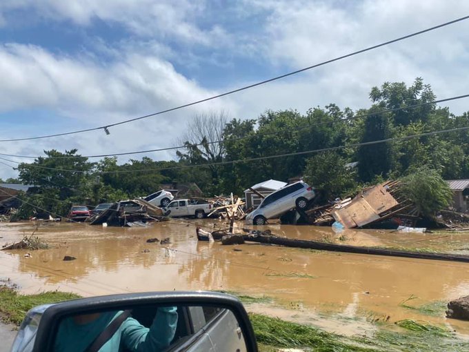
Thank you all for following along today. Today was a historical event for all the wrong reasons.
Normally I’d share my Patreon link at this point, but I’d rather you donate to help recovery efforts, as our friends need help.
4
2
45
I likely missed a lot of your tweets tonight. Things got…. hairy… when you run two accounts while having to shelter yourself with multiple rotation couplets trying to tweet from your phone.
8
2
39
Dickson County EMA sending text alerts stating "All roads are nearly impassable due to ice and snow. Most have vehicles left on sides of roads. Do not get out unless emergency."
2
11
39

My mentions were the craziest they’ve ever been on this account, but it makes me proud of y’all to hear you all got the warnings, got to shelter, and was telling me so.
1
0
36
Just crossed over 3,500 followers here.
🤯
Incredibly thankful you all are here.
4
0
34
Tornado warning has been cancelled for Dickson County
3
2
32
Yes, y’all. Tornado warning for southern Dickson County. PLEASE TAKE SHELTER.
3
7
33
.
@NWSNashville
has determined an EF1 tornado touched down in Burns.
EF1 Tornado.
Max winds 110mph.
175 yards wide.
5.3 miles long.
0
16
30
I should have posted this on Saturday, but I will post it now.
Damage paths/tornado damage areas are not tourism spots. Please do not go driving through just to sight see.
You’re getting in the way of those helping to clean up and rebuild.
0
3
32
.
@NWSNashville
has determined the tornado that went through the Pomona area, between Downtown Dickson and I-40, as an EF2 tornado, with max winds of 130mph and 500 yards wide. The length is still being determined.
1
9
32
Y’all.
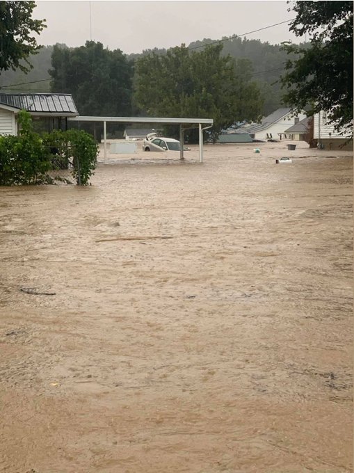
The flooding is bad. Real bad.
Please stay home and do not get out on the roads. Do not go sight seeing. Do not go out unless *absolutely necessary.*
Flooding is life threatening and we want you safe. You’re not safe on the roads today.
2
4
30
So if it ends up with less snow on the ground than the map has indicated, you can respond with “Oh yeah,
@DicksonSevereWx
and
@NWSNashville
said this was a possibility” instead of “those weather people don’t know what they’re talking about, they hyped it for nothing, yada yada.”
2
0
32
I will take winter weather event after winter weather event any day of the week over that tornado nonsense.
#bringiton

Last 7 days:
✅NYE bad storm dodge,
✅NYD tornado warning,
✅NYD record high temp,
✅Winter Weather Advisory,
✅22 returns 👑,
✅Winter Storm Warning
#HalfAFoot
who invited 2022
16
156
753
2
0
31
I’m also very aware of Twitter’s new (hopefully temporary) limits on how many tweets can be read per hour.
I hope this doesn’t impact my ability to tweet here during storms, or your ability to see those tweets.
But to be sure, have multiple ways to get weather info today.
1
0
30
Disorganized storms (previously tornado warned but not now) moving through now. It's a good sign that it weakened before getting here, and we hope that trend continues tonight. But be prepared in case it doesn't.
1
0
29
This was one of those events that had all the ingredients and parameters of severe weather, but one tiny thing was off (today, it was mid level lapse rates for the nerds out there).
Thankful it did not live up to the potential today.
2
1
30
I cannot answer road condition questions.
However, let me answer your road condition question:
Road is bad. Stay home.
1
6
28
Storms moving through currently are non severe. They don’t appear to be strengthening but that doesn’t mean they can’t. There’s plenty of instability around to work with, but the storms currently appear too lazy to want to do anything.
(I’m also often too lazy to do anything)
2
1
29
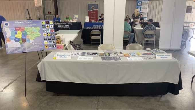
Thank you everyone who came to see me today at the Dickson Co Fairgrounds! Met so many of you, some I even recognize here!! Y’all are the best followers, hands down, and no one can tell me otherwise!
Thank you for the sweets y’all gave me too! Totally surprised and thankful!
1
0
28
Storm to our west that we are watching closely because of the tornado warning is rapidly weakening. I doubt a tornado warning will be continued for it. Regardless, I'm watching it.

3
2
27
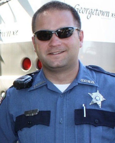
Thank you Seargent Daniel Baker for watching over our community and keeping it safe since your first day as a police officer and now watching all of us from above. Thank you for your dedication and service.
0
5
27
Tornado Warning for Dickson County has been cancelled. Storm has weakened and is about to be in Cheatham County.
4
4
28
Now let’s talk about forecasts and human behavior (aka my rant).
We as humans like concrete answers. We like certainty, absolutes, black and white. Rarely in life is anything any of those adjectives.
2
7
27
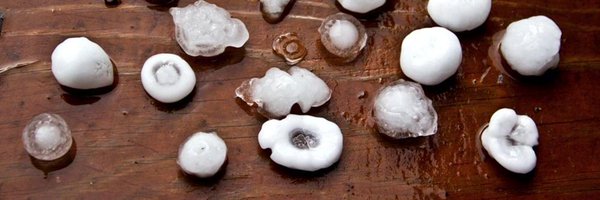
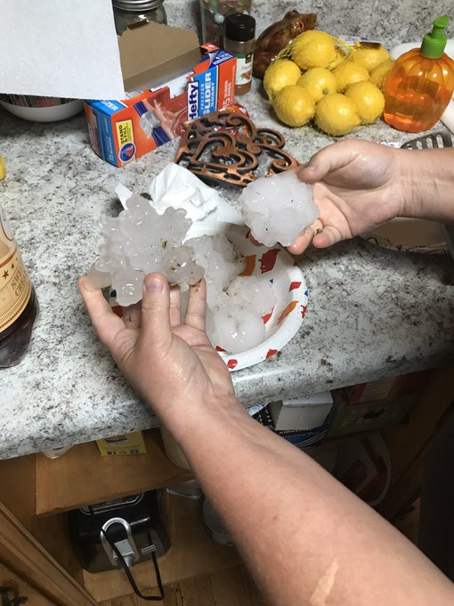
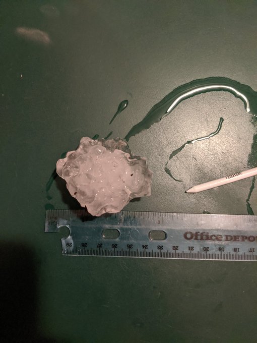
Near 3 inch hail in downtown Charlotte near Hwy 48N.
#tspotter

2
3
26
Our tornado watch has been officially cancelled. Our severe weather threat is over.
Enjoy the rest of y’alls night. Thanks for hanging with me today.
4
0
27
Dickson County Schools are closed Tuesday, January 16, 2018 due to conditions in the northern part of the county and due to current forecasted snow.
0
15
26
I want to thank each and every single one of you for following me over the last seven years providing hyper-local weather information for Hickman County.
Your support, your comments, your reports, and your trust keeps me going and are all so very much appreciated.
2
0
27
Me, a few hours ago: Snow is pretty, won’t accumulate.
Me, now: Oh, my deck is covered.
1
1
27
Sliding in here to say... y'all need to peep this weekend's forecast.
3
3
27
Folks, it appears we’ve reached the point of no return where the roads are concerned.
They are iced over, everywhere.
Unless you absolutely have to be out, don’t risk it. You don’t want to hurt yourself or others, or damage your ride.
It’s not worth it.
1
10
26
Y’all.
Y’all!!
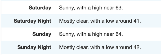
Look at this drop in humidity that will come and grace us with its presence tomorrow afternoon.
Just look at how beautiful it is.
3
1
27
The benefit of following me here on Twitter is that I’m taking info from all these different sources, filtering through it, and telling you what you need to know for Dickson County. I’m hyper-focused on Dickson County.
Other sources are giving more broad info for Mid TN.
2
1
27
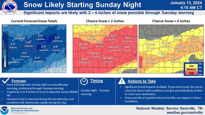
Alrighty, time to break the silence on this winter weather I’ve been avoiding trying to discuss.
It’s bitter cold currently and will be until at least Thursday.
A system will move in giving us a chance of snow starting Sunday night through Tuesday.
1
1
26
Yesterday I learned that there are quite a few of you who didn’t know there was a RadioShack in Dickson.
1
1
26
It’s been a minute since we have had severe weather, but today ends that quiet streak.
We are expecting to see some strong to severe storms today ahead of a cold front during the afternoon hours.
Damaging winds are the main threat, with hail and weak tornadoes being secondary
1
2
26
We also blew through a huge milestone here. 3,000 followers, with over 200 joining us today.
Thank you all for following me as one of your trusted weather sources.
2
1
26
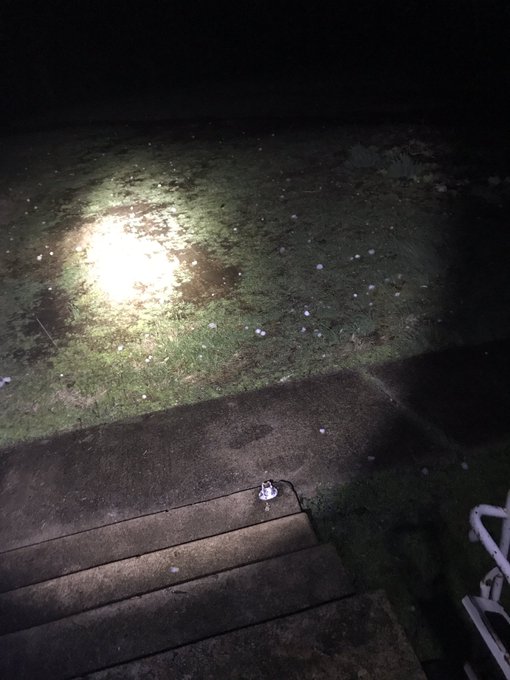
Y’all, I had to take shelter myself. Tweeting what I can from my phone.
4
0
25
Dickson County, you are safe to head to bed for the night. Extreme southeastern part of the county still have a tiny bit of storm left, but it will be out of the county in the next 10 minutes.
2
2
25
Dickson County has been cleared of all tornado warnings.
You may come out of your safe spots.
7
2
24
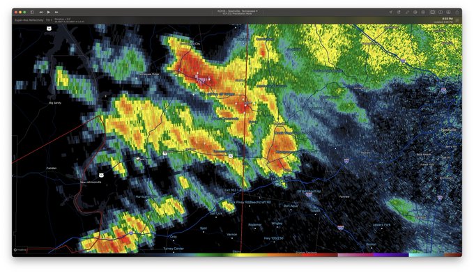
Latest models show a line of storms forming, with a tiny line forming after it. Where that main line sets up and forms is the current question for us. It could set up just west of us, on top of us, or miss us all together.
Currently watching to see where that line sets up.
3
1
24
I have not been able to keep up with mentions, nor can I reply to every single one. Please read back through my tweets.
When in doubt, take shelter.
1
0
24
Tornado Watch has been cancelled for Dickson County.
Severe weather threat has ended.
Thank y’all for following and I hope you and your families are safe.
Sleep in this morning.
2
2
24
Well folks, just like we thought, the warm front didn’t make it as northward as needed for severe weather today. I’m good with that though.
However, let’s not forget we have another (possibly better) chance on New Years Day (Saturday).
Will have more deets tomorrow on that.
1
1
24
Thank you all for the new milestone tonight!
2,500 followers.
Y’all have no idea how this feels. I have no words.
❤️
3
0
24
NEW: Tornado Watch for Dickson County until 5am.

A tornado watch has been issued for parts of Arkansas, Louisiana, Mississippi, Missouri and Tennessee until 5 AM CST
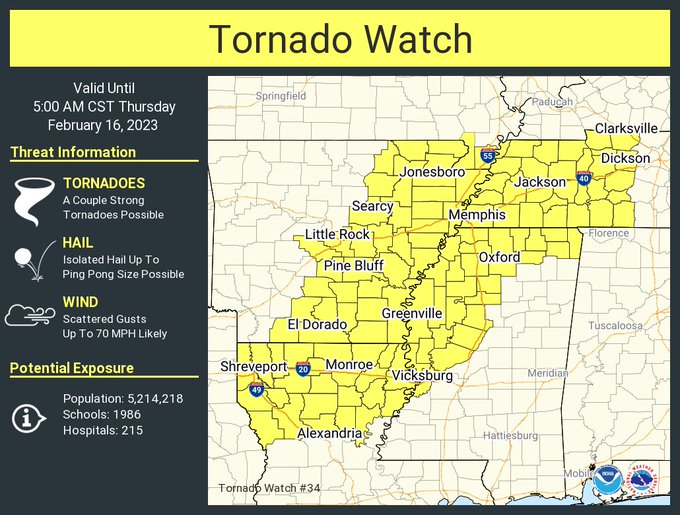
6
166
313
3
5
19
I just want to say thank you for all the kind words and outpouring of support from this morning’s storms. Although we had serious hail, we dodged a bigger bullet, both fortunately and unfortunately. The kind words keeps fuel in my tank to keep going and keep doing this for you.
2
0
22
Y’all are smart.
I know y’all ain’t believing the random snow maps being posted by randos on the internet.
Y’all know snow forecasting is hard in TN and to trust your reputable weather sources.
Y’all know how this works. And I’m proud of you.
2
0
22
Little nugget before y’all head to bed:
NWS has expanded the Winter Storm Warning earlier today, but doesn’t include us.
They’ve hinted at possibly expanding again (our way) overnight. This means they may anticipate more snow than currently forecasted.
2
1
23
TVA has ended the call for blackouts for now. They are still asking customers to conserve as much as possible.
1
4
23
Sun is increasing west of us causing instability to build ahead of the main event. This will help give storm fuel to those storms.
Stay weather aware for the rest of the daylight hours as another round of storms is expected.
2
1
23
I’ve been watching and paying attention… but quiet for a reason.
I’ll break my silence tomorrow ☺️

2
0
23
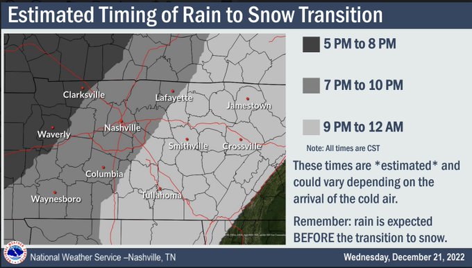
The changeover from rain to snow will start between 7-10pm.
Plan to be home before this time as anything that transitions WILL STICK to the roads.
2
4
21

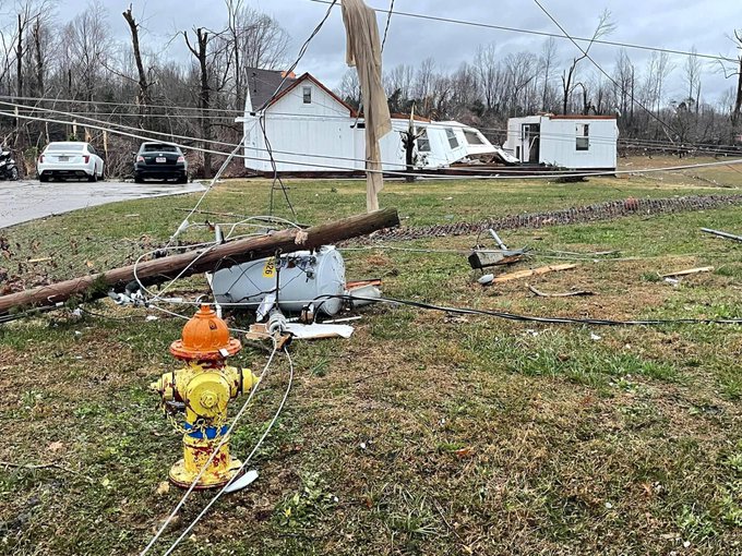
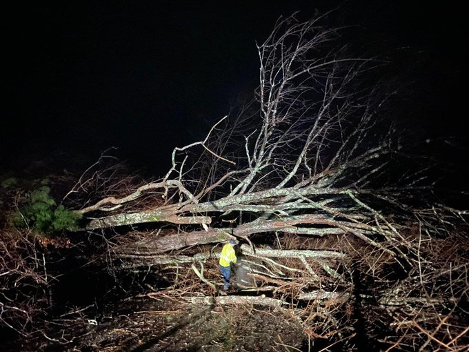
NWS Nashville will be doing storm surveys in White Bluff today to determine more about the damage that happened Saturday afternoon. Will post more info when I receive it.
1
3
22
If you're out and about, you really only have about 1-2 hours to get back home safely before things start becoming very dicey on the roads.
If you're out and about, get home asap. You don't want to chance it.
0
4
21
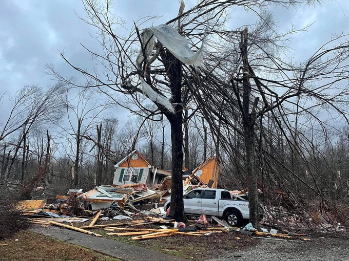
Preliminary (subject to change):
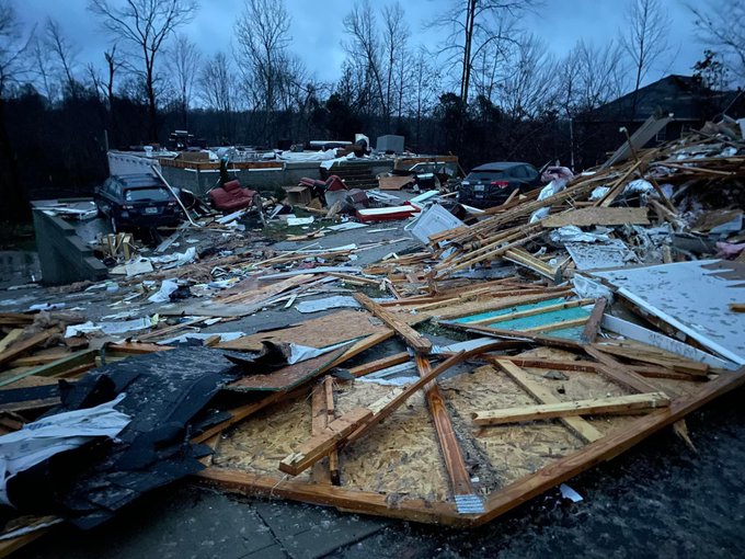
Cumberland Furnace Tornado: EF2, max winds 125mph. Path 5.13 miles long, 300 yards wide.
Will get the tornado path map when NWSNashville releases.
Also awaiting to hear about damage in White Bluff.
1
3
22
We’ve been upgraded from a winter weather advisory to a Winter Storm Warning from 5 am to 8 pm.
3-5 inches of snow forecasted for us.
3
3
22
@NWSNashville
Cars are floating in Waverly, some reports of people in those cars. Posted 1 hr ago on Facebook (multiple reports of people trapped, cars floating, etc.) .
#tspotter
2
16
22
We're looking at another chance of severe weather tomorrow afternoon to evening and overnight. SPC has us outlooked in the "Enhanced" (3/5) chance for severe weather, as a line of storms expected to move through and potentially stall.
2
2
21
This was not the main event. More storms are expected later today.
2
1
21
Tornado Watch has been cancelled for Dickson County. Our severe weather threat is over.
2
1
20
Dickson County, we are almost in the clear. We have no warnings, but until the rain stops, I don't want y'all going to bed/taking your eyes of the weather right now.
3
3
21
If you must get out, clean the *entirety* of your car off before moving it.
Seriously, the ice and stuff on the hood and top of your car is an ice missile that will damage the car behind you.
2
4
21
Yes, and will be posting updates here shortly.

2
0
21
Thank you for the kind words!

2
1
20
This tornado warned storm is on the path to come straight through the center of Dickson City
EVERYONE in the city limits and surrounding Dickson Need to be in your safe spot.
1
3
19
All I have to say right now is:
The dew point is dropping, the dew point is dropping!
2
0
20
Storms have officially cleared our county. We have some rain still but the severe weather threat has pretty much started to diminish for us.
Winds will continue to be an issue for the rest of the day.
2
1
20
For those asking, if the 17.02” of rain that fell since midnight in McEwen is verified, it will absolutely crush the current state record of 13.60” that fell within a 24-hour period in Milan on September 13, 1982 (all records have to be quality control before made final).
0
6
18
Tornado warning has been replaced with a severe thunderstorm warning with possible tornado. That means it's weakened a bit but could strengthen again.
1
2
20
Living/working/playing/etc in another county today? Be sure to follow that county’s
#tspotter
coordinator to get hyper-localized wx info!
0
12
17
Ok, I’m ready to talk about snow.
Confidence is increasing for Middle Tennessee to see some snow as early as 7am Tuesday morning.
Rain will change over to snow in the early to mid morning hours, ending late tomorrow night.
0
2
19
Congrats
@NashSevereWx
for reaching 200,000 followers tonight!!! HOLY MOLY y’all are awesome and this is well deserved!!
0
0
19
Heads up Dickson County.
Tornado Warned storm will be coming into the county over the next hour to two hours.
NOW is the time to be weather aware and watch the radar. Tornados today have already been reported, including in Clarksville.
0
3
20
Currently being vague intentionally so first responders can work.

0
0
20
The risk is kind of meh. Rumbles of thunder and lightning, but enough severe ingredients don't seem like they are going to be in place enough for us to worry.
Stay tuned though, but otherwise, meh.

@DicksonSevereWx
hearing potential severe weather but nothing on any apps I’ve seen. Any thoughts? Thanks for all you do!!
0
0
0
0
0
20
Preliminary (subject to change)
White Bluff Tornado:
EF2, max winds 125mph
13.7 miles long
500 yards wide.
Will share map when released by NWSNashville.
1
2
19
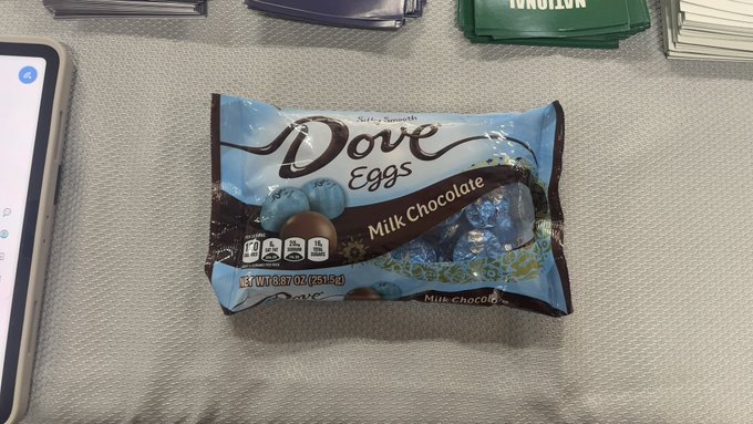
My better half just brought me an entire bag of Hershey milk chocolate eggs, knowing I need them today.
He’s a keeper, and knows he has slim to no chance of any of these being left over by the end of the day.
3
0
18
Our Winter Storm Warning is now in effect from now until 6am Tuesday morning.
0
3
19
I’m doing my best. Current forecast still holding with that at least.

@DicksonSevereWx
Look
@DicksonSevereWx
, as long as you keep that number at 0.20" or below, we're FINE, still friends, all good... but let it get to a quarter inch or higher and things could get a LITTTLEEEE tricky.😕
0
1
7
0
0
19
I’m very trigger happy on the retweet button, so pretty pictures and videos might just get shared. 👀
4
0
19
Snow is likely to start falling in the next hour - slightly ahead of schedule. Once it starts, anything falling will stick and could start causing traffic issues sooner than anticipated.
0
4
18
Center of circulation has now left Dickson County into Cheatham County.
You can now leave your safe space.
3
1
19