Convective Chronicles
@ConvChronicles
Followers
11K
Following
12K
Media
2K
Statuses
6K
One-stop shop for in-depth forecast discussions and case studies for upcoming and past severe weather events across the United States.
Joined April 2022
Staring up the mesocyclone of a strong, rain-wrapped tornado near Tomah, WI, on June 15, 2022.
1
10
77
My full footage from the beautiful tornadoes near Briggs, TX on May 1, 2025 is up on my Patreon page. Become a member today to gain access to exclusive chase videos like this one, full ad-free previews of my YouTube videos ahead of their release, and more. LINK:
2
11
106
Alongside an active year for tornadoes, it's been an above-average year for damaging wind reports, as well. 2025 trails only 2011 and 2023 (for years since 2010) in damaging wind reports to this point. On the other hand, it's been a slightly below-average year for large hail
1
10
68
Strong winds and storm surge batter Surfside Beach, TX, as Category 1 Hurricane Beryl makes landfall on July 8, 2024.
0
7
67
Work has begun on my next video, a breakdown of the April 28, 2025, Moderate Risk event across Minnesota, Iowa, and Wisconsin. Despite forecasts calling for several long-tracked, strong/intense tornadic supercells, only a handful of shorter-tracked, weaker tornadoes occurred
14
15
196
Incredible haboob rolls up Interstate 10 near Casa Grande, AZ, on August 25, 2025.
2
7
63
LINK: https://t.co/vm6ecAf3rx Part 2 of my meteorological breakdown of the June 20, 2025, Northern Plains severe weather outbreak is up! In it, Storm Prediction Center meteorologist Chris Broyles discusses the thought process behind the forecast for that day using several
3
27
146
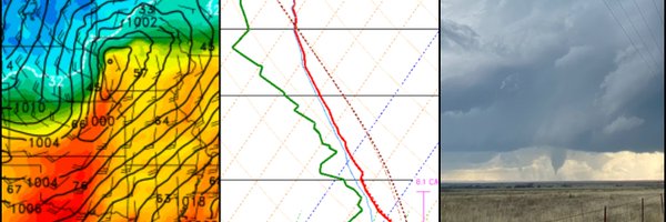
Classic sleet/freezing rain sounding from Norman, OK, this morning, which has led to an impactful winter weather episode across central Oklahoma that began several hours ago. The warm layer around 800 mb caused precipitation to melt some as it descended, but sub-freezing
1
11
84
My second video on the June 20, 2025 severe weather outbreak and the Enderlin, ND EF5 will be released Monday at 1pm CST with a very special guest, SPC meteorologist Chris Broyles! Chris helped author the 06z Day 1 outlook on June 20, and in this video, he talks about some of the
15
56
411
A Marginal Risk (level 1/5) remains in place across east Texas and far western Louisiana. Ample convection is expected ahead of a southward-surging cold front this afternoon. The majority of updrafts will be undercut by the quick-moving front, but the more robust storms will have
0
4
16
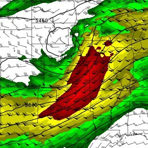
A high-impact winter storm is expected to take place this weekend across the Midwest. WPC data shows a 90-95% chance of accumulating snowfall greater than 8" from central Iowa into northern Illinois through Monday morning, with ample snowfall extending into places like southern
2
9
105
🌪️ A messy morning convection field. A fading MCS. And one storm that got it just right. Watch the full forecast-to-field breakdown of @ConvChronicles's September Plains chase for FREE. 🎬 Link in replies!
2
7
22