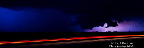

Justin Rudicel
@ChasingtheMeso
Followers
7K
Following
1K
Media
9K
Statuses
23K
TV Meteorologist for KWTV News 9 (CBS) Oklahoma city. I love my family, weather, football, photography, IndyCar, & chasing storms. https://t.co/WEsn3mlUYD
Oklahoma city, Oklahoma
Joined February 2010
MORE WIND & FIRE DANGER FRIDAY: It will be cold tonight as lows drop into the 20s. Fortunately, winds will die off this evening. Thursday will warm some. Expect highs in the 50s central and 60s west. Wildfire danger will kick back in Friday. Winds could gust 30 to 50 mph!
0
0
0
TURNING COOLER, WINDS & FIRE THREAT GO UP: A cold front will push thru tonight and drop afternoon highs to more seasonable 40s & 50s. Winds will gust to near 40 mph, so fire danger will moderate. With more gusty winds & fire danger on Friday.
0
0
0

HILARIOUS: ELI MANNING SURPRISED HIS BROTHER PEYTON WITH A MASSIVE BOARD COMMEMORATING HIS HISTORIC 28 INTERCEPTIONS IN ONE SEASON… Eli found the cards of each player who intercepted Peyton that season and had them custom-made. All-time gift 🤣🤣🤣 https://t.co/AIF4X1p4rQ
223
3K
45K
MILD AIR ENDS TUESDAY, FIRE THREAT ELEVATED WITH GUSTY WINDS AHEAD: Highs will warm back up Tuesday with 60s and 70s returning. A cold front will begin a cooler pattern starting Wednesday. Fire danger will be elevated on the days with high wind gusts.
0
0
2
We are warming things up early this week! 60s return both Monday and Tuesday afternoon. We'll be sitting about 10-15 degrees warmer than normal for this point in January. The first cold front of the week brings a blustery north wind and cooler temperatures in on Wednesday. #okwx
0
4
9
CHILLY FOR SUNDAY, WARMER HIGHS RETURN BRIEFLY: Bright and sunny today but will stay cool. 60s return Monday and Tuesday, then colder air will sink back into the state thru Saturday. A slight chance for precip is possible on Friday.
0
0
1
Scattered snow showers come to an end tonight in northwestern Oklahoma. Temperatures take a turn for the colder across more of the state. Many of us wake up in the low 30s or colder Saturday morning. Saturday and Sunday afternoon look sunny and cool for the Sooner State. #okwx
0
5
7
Clouds increase with a couple of showers possible overnight. Tomorrow morning, a wave of storms will race across the area with the threat of a little wind & hail. By the afternoon, we'll be sunny & warm. A wintry mix for some on Friday. More details on https://t.co/WenCxcSEU9
0
0
2
MILD WEDNESDAY, RAIN/STORMS MOVE IN WEDNESDAY NIGHT - THURSDAY: Another very warm day expected for Wednesday with highs in the 60s & 70s. Rain & storms form late Wednesday night & continue into Thursday. Some could be severe with wind and hail. Some totals near 1/2" for OKC.
0
0
0
Record high today!! Warm S winds will switch to a N wind overnight with lows in the 40s. Highs tomorrow under lots of sunshine will remain well above average in the 60s. Tracking rain & storms for Wed Night into Thursday. Some areas could see over half an inch of rain. #okwx
0
0
0
WARMER, FIRE DANGER THEN RAIN CHANCES! Warming highs are on the way... Even record setting highs look possible on Monday. Fire danger will elevate especially in west OK. Rain chances increase Thursday!
0
0
0
Some clouds increase overnight under a light north wind. Tomorrow highs will be closer to seasonal averages with plenty of sunshine. South winds return on Sunday for a beautiful afternoon with highs in the 60s. 70s expected on Monday before maybe some mid week showers. #okwx
0
0
0
Tracking the chances of showers later this evening into the overnight. Nothing heavy or widespread but at least there is a chance of RAIN. Lows in the 30s & 40s with clearing skies by sunrise. Skies go sunny for Friday with highs above average in the 60s. #okwx
0
0
1
We're almost to 2026, but our weather pattern doesn't want to change. A cool & quiet overnight with lows in the 30s. Tomorrow, clouds increase as a fast but weak weather system could bring a couple of showers to the state. Mild weather looks to continue next week. #okwx
0
0
1
Not as cold tonight with lows in the 20s under clear skies. The last day of 2025 will once again be on the warm side. Temps will cool down quickly as we ring in 2026 in the 30s. Mild weather continues into the New Year as we continue to search for precipitation. #okwx
0
0
1
A nice, mild start this morning, but it won't last long. A strong cold front will bring falling temps & winds gusting over 40 mph this afternoon. North winds will produce wind chills in the single digits by Monday AM. The cold air won't last long with 60s by 2026. #okwx
0
0
0
Here comes the cold! Temperatures will fall into the 40s and 30s through the afternoon tomorrow as a powerful cold front brings in a gusty north wind. Wind chills early on Monday will have a bite. A shock to our system after a week of record high temperatures! #okwx
0
7
18