
Craig Ceecee, Ph.D.
@CC_StormWatch
Followers
24K
Following
108K
Media
10K
Statuses
83K
Meteorologist (from @msstate x2) focused on tornado protection, founder of Find Your Tornado Shelter LLC. @nwas and @ametsoc member. #STEM advocate. Mark 9:23.
Mississippi
Joined April 2017
Watching the stories from #Katrina are really emotional. I remember being horrified by both the news that it strengthened to cat 5 as it approached the LA/MS coast, as well as the images in the aftermath of the human suffering and the devastation. I esp. think of @MargaretOrr.
4
0
26

20 years ago today, we were five days away from #Katrina making its horrific Gulf coast landfall. One thing I wonder is what would happen if the models were like they are today - would the forecast be more accurate this far out? This was the 5-day forecast AT THE TIME.

6
23
133
RT @CC_StormWatch: With back-to-school season in full swing, it's also a good time to get back to preparing for the upcoming #severe weathe….
0
7
0

If you want to help a teacher get research posters done, here's a link to gift the products!.
1
4
14
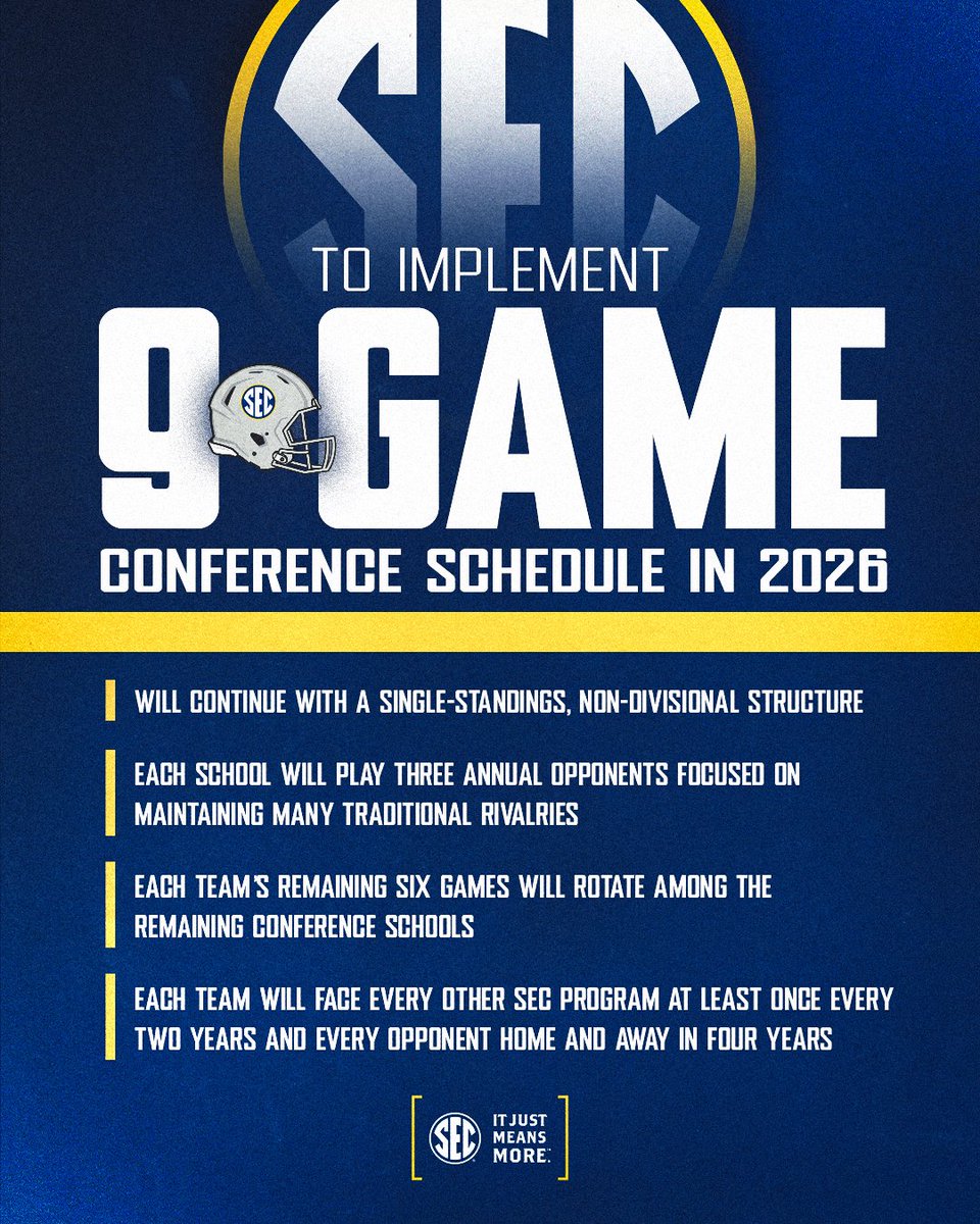
A good or bad move?.

🚨 @SEC to implement nine-game conference football schedule beginning in 2026, reinforcing the SEC’s position as the nation’s leader in competitive excellence and fan excitement. 🔗 #SECFB x #ItJustMeansMore
5
1
3
See the lines that move from NE to SW ahead of #Erin? That's the cold front. Also the blue area to the northeast is an opening out to sea.
0
1
5
If you're in the eastern US and saw rain today, you should be happy. It's that same front that's steering #Erin away. Without the front, OR if there was a ridge near Nova Scotia (there isn't one), Erin would be heading for a catastrophic landfall. We're being spared by the front.

2
11
40
RT @Bbabybear01: Tonight on dumb things people do in storms. #Buxton NC. WHY? Just Why. 🤦♂️ This is in the area of the Mandatory Evacuat….
0
3
0
RT @amarkowitzWX: If it wasn’t for that cold front in Canada, which is steering it out to sea, Erin would have been a catastrophic storm fo….
0
13
0
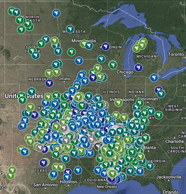
RT @CC_StormWatch: Just finished a poster that I can't wait to present at #NWAS2025. It shows that one region of the country has been VERY….
0
2
0
While there are some impacts from #Erin, it is literally taking the best possible path between the east coast and Bermuda. If it was 300 miles west, we'd be watching a large hurricane approach land. 300 miles to the east, it would be making a direct hit on Bermuda.
0
2
32

Having to remember old math formulas, and even look at calculus rules, for a poster I am presenting basically takes me back to school. That's why any meteorologist you see on air or at a desk is also a scientist.
0
0
12
It's really annoying when the Hurricane Hunters aircraft has to turn around and return to base (due to technical or safety issues), but necessary for their sake. They can't afford to risk anything when flying through a hurricane. #Erin.
1
4
43
I've been watching the stories and recollections of Katrina. In the days before social media. I remember those days watching the coverage and I was feeling so sick afterward and helpless even from thousands of miles away. I'll never get over the images.
5
2
58
RT @ZackFradellaWx: CATASTROPHIC ERIN - Erin has rapidly intensified into a Cat 5 with winds of 160 MPH, pressure down to 917 MB. https://t….
0
16
0
Now a Category 5. #Erin has undergone absolutely remarkable intensification this morning. How much stronger can it get?

5
14
97