Explore tweets tagged as #Remote_sensing

💡💡 Evaluation of #Urban Microscopic #Nighttime #Light Environment Based on the Coupling Observation of #RemoteSensing and #UAV Observation. ✍️ Baogang Zhang et al. 🔗

1
3
19

From conference rooms in Hawaii to soybean fields in Illinois. Back to scouting sites in Shelby County for our ground truth data collection. #BootsOnTheGround. #AgTech #RemoteSensing #FieldWork #SmartPlantPathology


0
0
3
🖼️🖼️ Few-Shot #Hyperspectral Remote Sensing #Image #Classification via an Ensemble of Meta-Optimizers with #Update Integration. ✍️ Tao Hao et al. 🔗

1
5
49

🌟 IEEE GRSS Professional Member Spotlight: Dr. Delwyn Moller. Dr. Delwyn Moller is a radar remote sensing expert and adjunct professor at the University of Auckland. A former NASA JPL researcher, she now leads her own consulting business and serves as the Chapter Chair for the

0
0
0
🎨🎨 A Texture-Considerate Convolutional #NeuralNetwork Approach for #Color Consistency in Remote Sensing #Imagery. ✍️ Xiaoyuan Qian et al. 🔗

0
0
2

BTTN Infographic| Pakistan’s space ambitions soar higher! The 2025 remote sensing satellite launch by SUPARCO boosts monitoring, agriculture & CPEC security. #PakistanSpace #SUPARCO #RemoteSensing #StrategicVision2040 #BTTN

0
21
27

GIS & Remote Sensing in Modern Cars.GIS: Maps roads, optimizes routes, tracks fleets. Remote Sensing: LiDAR, radar, cameras detect obstacles, weather. Together, they power navigation, autonomous driving, and safety!. #GIS #RemoteSensing #SmartCars #Ai #car #technologie #all

0
0
0
👉👉 The Right #Triangle #Model: Overcoming the Sparse Data Problem in #Thermal/#Optical Remote Sensing of #SoilMoisture. ✍️ Toby N. Carlson et al. 🔗

1
0
10

China successfully sent Pakistan's remote sensing satellite-01 into preset orbit via the Kuaizhou-1A carrier rocket on Thursday morning from Xichang Satellite Launch Center in SW China’s Sichuan Province. The satellite is tasked to provide services including national land survey
38
181
860
💧💧 Framework for Regional to Global Extension of #Optical #Water Types for #RemoteSensing of Optically Complex Transitional #Water #Bodies. ✍️ Elizabeth C. Atwood et al. 🔗

0
0
3

I developed a wildfire intelligence geospatial analytics system using NASA open-source satellite remote sensing data 🔥. 🛰️ NASA remote sensing data integration.🌲 Burn severity mapping (NBR, dNBR & RdNBR).📊 Temporal fire progression analytics.🗺️ Automated GIS visualizations

6
21
101

Pakistan successfully launched a remote sensing satellite from China’s Xichang centre, aimed at strengthening agricultural monitoring, disa_ster response, urban planning, and climate tracking. Disclaimer: Image is just for reference. #PakistanSatellite #SUPARCO #ChinaPakistan

5
61
429


Pakistani 🇵🇰- China 🇨🇳 Friendship. Pakistan Successfully Launches Remote Sensing Satellite . In a major milestone for space exploration and technological progress, #Pakistan today successfully launched its Remote Sensing Satellite from the Xichang Satellite Launch Centre (XSLC)
96
158
568

東京や横浜とその周辺の夜景をISS(国際宇宙ステーション)から撮影した画像。2025年6月28日0時38分ごろ(日本時間)に撮影されました。. Image courtesy of the Earth Science and Remote Sensing Unit, NASA Johnson Space Center. (1/2)

4
239
1K
🌏🛰️ Seasonal Dynamics of the #LandSurface Characteristics in #Arid Regions Retrieved by #Optical and #Microwave Satellite Data. ✍️ Ying Tian et al. 🔗

0
3
10

Meet Esri Senior Solution Engineer Canserina Kurnia, as she shares her journey into the world of imagery and remote sensing — and how she now collaborates with educators and researchers to apply these powerful tools in shaping the future workforce 👇

0
0
9

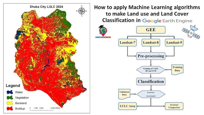
Tutorial about Land Use Land Cover Classification using Machine Learning || Google Earth Engine for LULC mapping.Tutorial Link: #LandUseLandCover #LULCMapping #MachineLearning #GoogleEarthEngine #RemoteSensing #GISMapping #EarthObservation #Geospatial
1
18
124

China has successfully sent Pakistan's remote sensing satellite-01 into preset orbit via the Kuaizhou-1A carrier rocket on Thursday morning from Xichang Satellite Launch Center in SW China’s Sichuan Province.
9
25
309