Explore tweets tagged as #MapViewer

Glyphosate/Chemical Herbicide Sprayed Cutblocks in BC

1
6
16
@StatisticsBC Link to new map: BC Glyphosate/Chemical Herbicide Spray 1970 to 2023 .@Jordan_Keal I have made my own arcgis map by importing the url for each layer in the BCimpas (links cut) So far I do not know what is being sprayed where but this iist immense.

0
2
2

Irelands Capital by % Irish: Red is less Ireland, Green is more. See the interactive map linked:.


It breaks my heart to say it, but this is Ireland. We are in serious trouble.
6
46
126

The amount of land that the federal government owns is obscene. It is also not all scenic park land. The proposal to sell a minuscule percentage of this obscenity is justified.


53
54
201

What if we focus on Manhattanizing the non-red parts of this map? (The red parts being California’s historical fire perimeters.).


42
26
307
@MarcNixon24 Glyphosate/Chemical Herbicide Sprayed Cutblocks in BC Pink indicates sprayed 7 times This is intense.

0
4
2

Racial Dot Mapがいつの間にか復活しててありがたい。家買うときけっこう参考にしてる。シアトルとシカゴのSegregationの違いよ


1
3
15

こいつらか.


クリミア半島エフパトリア隣のザオゼルノエ付近でS-300SAMが見つかったらしい。.ただ発射コンテナが地面に直接立っていて、陣地らしいものも見当たらず人もいないので、ダミーかもしれない。.

1
6
16
I have made my own arcgis map by importing the url for each layer in the BCimap (links cut) So far I do not know what is being sprayed where but this list immense.
@StatisticsBC I have made my own arcgis map by importing the url for each layer in the BCimpas (links cut) So far I do not know what is being sprayed where but this iis immense.

4
10
21
📊 Discover Kenya’s Weather Maps with KMD MapViewer!. Explore Kenya’s climate like never before — free access to weather & environmental data at your fingertips. 🔍 Explore features like:.•Daily & 10‑day maps for rainfall, temperature, wind, humidity, soil moisture, pollution,


0
1
7


What's new with Accessibility in Arcade? The June 2023 release of ArcGIS Online includes a new accessible color palette for syntax highlighting in the Arcade editor in MapViewer.

0
0
0
Seven Mill, pre construction, was fields & 73% ethnic Irish. Shown circled in red/X. Adamstown is an example of new, post emigration, developments. Adamstown is almost entirely minority Ethnic Irish. Link to webmap


Over 60 people are sleeping out overnight in the hope that they can buy new homes that go on sale at Seven Mills in Dublin tomorrow morning. The three beds are priced at €480k, €490k and €500k. Some people have been queuing since 3pm this afternoon.


4
14
39

The red areas are where the Irish are a minority in Dublin. Someone has mapped the entire country based on the last census. Almost all major towns look similar to this.

Irelands Capital Mapped by Ethnic Irish, last Census. Red is under 50% Ethnic Irish. See Interactive Webmap here:.

14
29
113

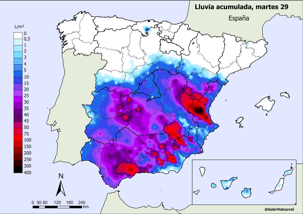
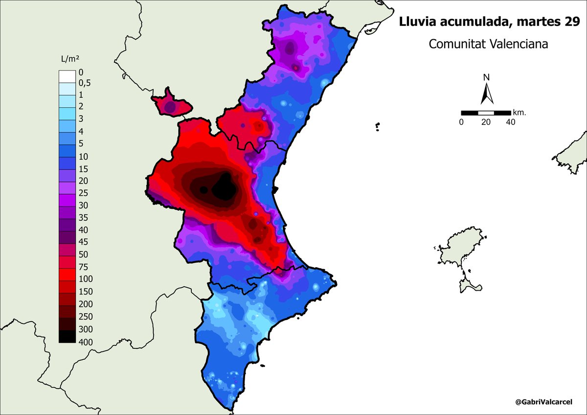
Lluvias torrenciales en España 🌧️ DANA catastrófica que se ceba especialmente con la Comunitat Valenciana ⚠️ Solo este martes han caído 490 l/m² en Chiva, 411 l/m² en Pedralba y más de 300 l/m² en Bunyol y Requena, provincia de Valencia.Mapa interactivo:
5
107
329


🗺️ Unlock the secrets of stream sediments and heavy mineral concentrates! Our new blog post reveals mapping techniques using Surfer and MapViewer. Check it out!
0
0
0

AEC federal election polling places - Results of 2022 Election (2 Party Preferred) overlaid with.ABS Statistical Area Level 1. % Australian Born Colour Mapped. Analysis by Irish Statistics @jimbobfrazzled .

17
26
168


