

EUSI
@EUSPACEIMAGING
Followers
6K
Following
948
Media
844
Statuses
2K
🛰 Satellite imagery for Europe and North Africa 📸 Native resolution up to 30 cm ⏳️ Near real-time delivery up to 15 min after collection
Munich, Germany
Joined May 2012

In collaboration with @EUSPACEIMAGING, @ESA has collected and released the WorldView-2 European Cities dataset 🌇 Covering Europe’s most populated areas at 40 cm resolution, it provides VHR data products acquired between July 2010 and July 2015. This March 2011 image 📸 shows
0
1
2
EUSI’s CEO Adrian Zevenbergen held a working session with EU Commissioner Andrius Kubilius to discuss the role of space-based IMINT in strengthening Europe’s wartime readiness. As Commissioner Kubilius highlighted: “Defence readiness is impossible without space readiness.”
0
0
1

Our member @EUSPACEIMAGING is among the 5 shortlisted companies for the #EARSC2025 Company Award! Meet them at #EXPANDEO2025 & discover the future of EO in Brussels 🌍 🔗 Register: https://t.co/OJvuQUGCyy
0
2
1
For example, in 2017 we collected imagery of a vessel involved in a transshipment of heroin. Information about its location was shared immediately with the Turkish authorities, who intercepted the vessel, arrested nine crew members and seized more than 1 ton of heroin.
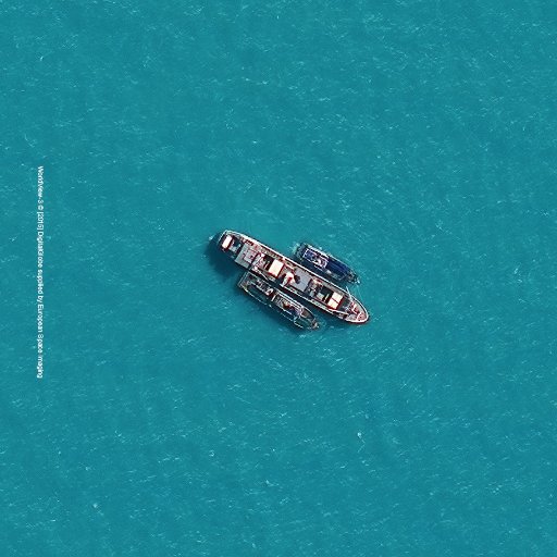
#DYK? If a vessel has stopped transmitting its position satellite🛰️ images can be used to confirm the vessel location.
0
0
2
It is our pleasure to announce a partnership with @Albedo, a builder of high-performance spacecraft and the first EO satellite designed to operate commercially in VLEO (Very Low Earth Orbit), to bring 10 cm satellite imagery to Europe and North Africa.
0
0
5
We collected new high-resolution satellite images yesterday (18 March) of the flooding across large regions of Tuscany, Italy. The images show flooded agriculture and rural infrastructure. Satellite Imagery © 2025 Maxar Technologies Provided by European Space Imaging
0
0
2
Impressive 50 cm 5x-Multilook SAR imagery from our partner @umbraspace. ⬇️

Greenwich, London, England, UK Featuring the O2 Arena, Bromley-by-Bow Gas Works, & ExCel London. Resolution: 50cm Number of Looks: 5 Collect Date: Monday, February 10th, 2025
1
0
2
Thank you to @DefenceGIS for bringing together international intelligence leaders and facilitating meaningful conversations about the defence and security of Europe.
0
0
1
Yesterday, we collected satellite images of the flash floods in #France. The 30 cm imagery, collected at 11 am using Maxar WorldView Legion satellites, shows the flooded streets, gardens, roads and fields. Satellite Imagery © 2025 Maxar Technologies Provided by European Space
0
0
2
Congratulations to @PixxelSpace who have just launched and deployed their hyperspectral satellites!

Deployment successful! 🚀 All three Fireflies are in orbit, ready to beam back a clearer, sharper view of our planet. 🌍✨
0
0
1
🛰️GEOEYE captured this stunning view of Kevitsa, one of Finland’s largest open-pit mines, located in Sodankylä, Lapland 🇫🇮. Kevitsa hosts some of Finland’s largest nickel and copper reserves. ✨ Key GEOEYE-1 features: 📌 Panchromatic imagery (up to 40 cm resolution) 📌 4-band
1
3
3
This satellite imagery shows the catastrophic damage after the Tropical Cyclone Chido that devastated the French territory of Mayotte in the Indian Ocean. Thousands of houses, buildings, and critical infrastructure have been destroyed while many other structures have been
0
1
3
The first images from the third and fourth WorldView Legion satellites were released by Maxar today. 🛰️ These two satellites are Maxar’s first in mid-inclination orbits, which is a game-changer. Here’s why: Within -45 and +45 degrees of latitude, they capture images at
0
0
1
We’re in Berlin, talking about the ultimate fusion of Maxar WorldView Legion and Umbra radar data for European Earth Observation. By synchronising the collections of 30 cm optical and 25 cm SAR, you can significantly enhance the monitoring and satellite data analysis
0
0
2
More images of the disastrous flooding in Valencia, Spain. Satellite Imagery © 2024 Maxar Technologies Provided by European Space Imaging
0
4
5
Just a few hours ago, we collected new satellite imagery of the floods around Valencia, Spain. These images are only a small sample of the extensive flooding damage that can be seen throughout hundreds of square kilometres collected today. In the 50 cm resolution images, you
2
23
52
Happy Halloween! 👻 Satellite imagery © 2024 Maxar Technologies Provided by European Space Imaging #halloween #happyhalloween #halloween2024
2
1
9
When needed, we can provide both SAR and Optical imagery in Near Real Time: ⏳ up to 15 minutes after collection for Optical imagery ⏳ up to one hour for SAR This is a huge benefit especially for emergency response and intelligence related operations, where the speed of
0
1
3
Oktoberfest in Munich, Germany #Oktoberfest #oktoberfest2024 #satelliteimage #satelliteimages #satelliteimagery Satellite image © 2024 Maxar Technologies Provided by European Space Imaging
0
0
1